.jpg.93eb8afe5d1df4d67bc0eeb78d645380.jpg)
.jpg.7cbeb4b469bd18d447fac5868c43a091.jpg)
Yardstickgozinya
-
Posts
1,650 -
Joined
Content Type
Profiles
Blogs
Forums
American Weather
Media Demo
Store
Gallery
Everything posted by Yardstickgozinya
-
.thumb.jpg.6a4895b2a43f87359e4e7d04a6fa0d14.jpg)
Central PA Summer 2026 Discussion/Obs Thread
Yardstickgozinya replied to Voyager's topic in Upstate New York/Pennsylvania
Yes sir. 11Lbs short of a personal best, but I'll still take it at 44lbs. The past two trips my son has hooked something absolutely monstrous and it's thrown the hook both times. My son and I are on some really big fish at the moment and I think it's only a matter of a trip or two until we land something on a whole other level. We've had some opportunities at something special the last few trips but we just can't land it. I've been a few pounds short of the state record twice in the past 20 years when it was still down in the 50lbs range. Now that it's at sixty six pounds, and i'm fifty years old, the Flathead record is starting to become a tall order -
Central PA Summer 2026 Discussion/Obs Thread
Yardstickgozinya replied to Voyager's topic in Upstate New York/Pennsylvania
For anybody who doesn't know the Colombia and Wrightsville area of the river is infamous for its mayflie hatch. The municipality has been turning off the lights on the bridge in response to several accidents, and even small pile ups that occurred due to mayfly hatches. The picture I included was found online, probably from a few years ago, before they turned off, the lights prior to may fly hatches.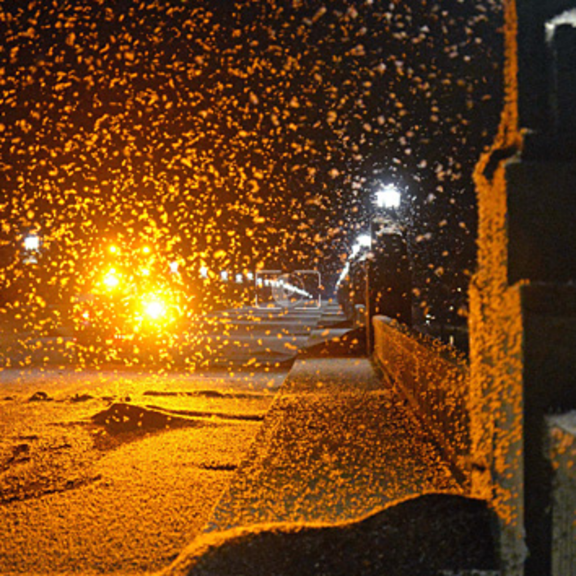
-
Central PA Summer 2026 Discussion/Obs Thread
Yardstickgozinya replied to Voyager's topic in Upstate New York/Pennsylvania
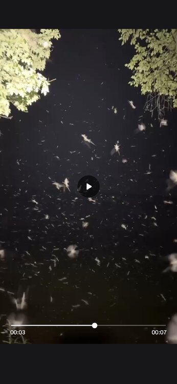
It took a couple stills from my videos from last night.I was adjacent to the Point rock tunnel in Colombia Pa. The route 30 bridge as only a few hundred yards in front of me, you can just make it out If you look closely. Between the mayflies and the smoke, you couldn't even see vehicle lights for more than a few hundred feet.
-
Central PA Summer 2026 Discussion/Obs Thread
Yardstickgozinya replied to Voyager's topic in Upstate New York/Pennsylvania
Tuesday Day 5 Days 4-6/Mon-Wed -- Great Lakes/Midwest to the Mid-Atlantic/Northeast... A shortwave upper trough initially over the Canadian Prairies and northern Plains will develop east/southeast across the Upper Midwest/Great Lakes on Monday, then the Ohio Valley and Mid-Atlantic vicinity on Tuesday. Meanwhile, another upper shortwave trough will develop across the Great Lakes to the Northeast/Mid-Atlantic on Wednesday. These features will support enhancement of mid/upper level flow as a surface low tracks across Ontario/Quebec and New England during this time. A trailing cold front will likewise progress east/southeast over this three day period, with a very moist and unstable airmass present ahead of the front. This overall pattern will likely bring multiple days of severe storm potential from the Upper Midwest/Great Lakes to portions of the Ohio Valley, Northeast and Mid-Atlantic vicinity Monday through Wednesday, necessitating severe probabilities. While these areas may shift some over the coming day as the timing of mesoscale features and influence of prior days convection becomes more clear, these general regions are most likely to see at least isolated to widely scattered damaging wind potential as the upper trough and surface cold front sweep across the area.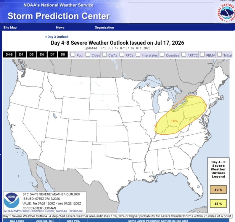
-
Central PA Summer 2026 Discussion/Obs Thread
Yardstickgozinya replied to Voyager's topic in Upstate New York/Pennsylvania
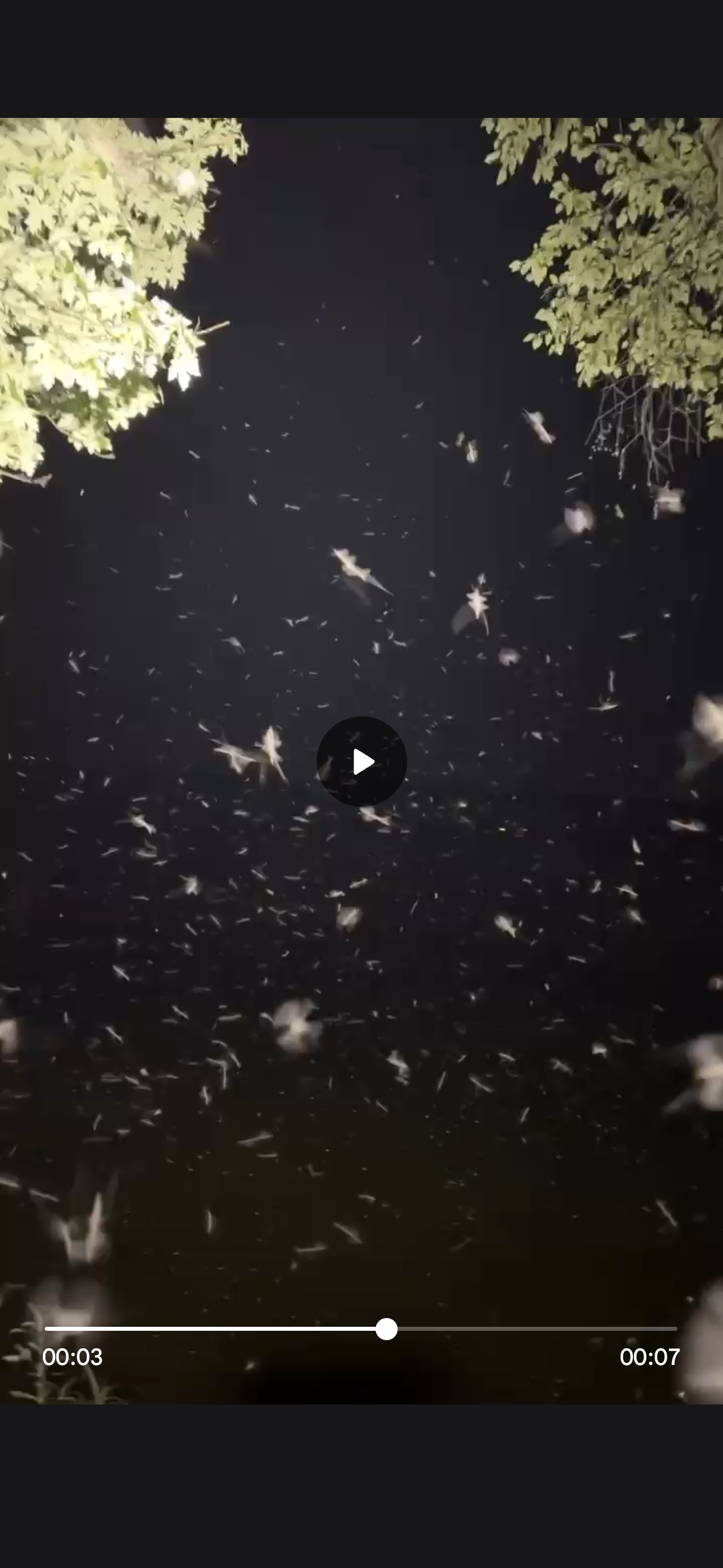
It got nasty out there last night while I was at my Colombia hole.. The Mayflies and the smoke were unbearable but my patients paid off. Sat out in this s*** all night last night, probably not the healthiest thing to do..thumb.jpg.8070da967ee470995b5d14b680187f04.jpg)
-
Central PA Summer 2026 Discussion/Obs Thread
Yardstickgozinya replied to Voyager's topic in Upstate New York/Pennsylvania
Given the increasing uncertainty as to the location of the surface boundary on Friday and the overall quality of the severe weather environment, unconditional 15% severe probabilities for Friday are removed with this forecast. It is possible that severe probabilities may be reintroduced in later outlooks should it become apparent that the surface boundary washes out earlier than expected and quality low-level moisture is able to return sooner. That said, the front should begin to dissipate by Saturday in response to a mid-level trough digging southeast across the Great Lakes. This will allow rich boundary-layer moisture to advect northeastward into the Mid-Atlantic and southern New England. This increase in boundary-layer moisture and strong diurnal heating will allow for afternoon MUCAPE values between 1000-2000 J/kg, perhaps locally higher on Saturday and into Sunday. This unstable and vertically sheared environment will be ripe for thunderstorm/severe thunderstorm development ahead of any digging mid-level trough. However, as alluded to previously, the timing, magnitude, and number of these troughs is highly variable within the ensemble guidance, leading to too little confidence to pinpoint where and when unconditional severe probabilities should be added. As confidence in the timing, track, and strength of these embedded troughs becomes clear, severe probabilities will likely be needed somewhere across the region stretching from the Upper Midwest southeast into the Mid-Atlantic for one or more days. -
Central PA Summer 2026 Discussion/Obs Thread
Yardstickgozinya replied to Voyager's topic in Upstate New York/Pennsylvania
Has anyone heard any annual cicadas yet his year ? Last year was a very weak year for them in my area, and this year doesn't seem like it'll fare any better. I thought the rain would help some emerge, but still nothing. -
Central PA Summer 2026 Discussion/Obs Thread
Yardstickgozinya replied to Voyager's topic in Upstate New York/Pennsylvania
According to last night's spc 4 AM update, some of the overlaps deterministic guidance was originally picking up on are in jeopardy. Timing issues. -
Central PA Summer 2026 Discussion/Obs Thread
Yardstickgozinya replied to Voyager's topic in Upstate New York/Pennsylvania
If I never post again, it was the mosquitoes that got me. -
Central PA Summer 2026 Discussion/Obs Thread
Yardstickgozinya replied to Voyager's topic in Upstate New York/Pennsylvania
There was so much grass and hydrilla uprooted from these last storms thet It's kind of a nightmare out there for a jet drive or fishing in certain areas. -
Central PA Summer 2026 Discussion/Obs Thread
Yardstickgozinya replied to Voyager's topic in Upstate New York/Pennsylvania
Hopefully, it's all still sitting exactly where you put it. -
Central PA Summer 2026 Discussion/Obs Thread
Yardstickgozinya replied to Voyager's topic in Upstate New York/Pennsylvania
Lightning's jumping around in the anville, far from any robust echoes. -
Central PA Summer 2026 Discussion/Obs Thread
Yardstickgozinya replied to Voyager's topic in Upstate New York/Pennsylvania
Anyways, I think it's squash and watermelon, something in th cucurbits family hard to tell when i'm driving. -
Central PA Summer 2026 Discussion/Obs Thread
Yardstickgozinya replied to Voyager's topic in Upstate New York/Pennsylvania
I was going to stop and snap some pictures out here in the Williams Grove area, because they grow several different types of produce, but the weather did not allow as I was driving through. Out here, the crops don't look too bad, but everything's irrigated. The corn on the edge of the fields that's not reached by the irrigation is stressed to the point where it will never produce a very viable crop. I'd imagine some of the unirrigated cornfields, look a lot like the edge of the cornfields out here in williams grove. Cabbage pumpkins, squash, watermelon all looks pretty decent out here. -
Central PA Summer 2026 Discussion/Obs Thread
Yardstickgozinya replied to Voyager's topic in Upstate New York/Pennsylvania
Heavy rain -
Central PA Summer 2026 Discussion/Obs Thread
Yardstickgozinya replied to Voyager's topic in Upstate New York/Pennsylvania
Srill just drizzle my nizzles.
-
Central PA Summer 2026 Discussion/Obs Thread
Yardstickgozinya replied to Voyager's topic in Upstate New York/Pennsylvania
I can smell the rain.dark clouds, east-west, north and south, but nothing here at my house. looks like I might get fringed again but that elongated cell just to my south might be able to get up here and help me out a little bit. -
Central PA Summer 2026 Discussion/Obs Thread
Yardstickgozinya replied to Voyager's topic in Upstate New York/Pennsylvania
The furthest northeast tip of York Co did not get hit we just got missed here earlier, but there's a few more small cells popping up around me now. -
Central PA Summer 2026 Discussion/Obs Thread
Yardstickgozinya replied to Voyager's topic in Upstate New York/Pennsylvania
I'd like to see that. It'd be cool if you could get it and put up a link. I tried to find a video of the radar loops from the 4th and 5th to post here, but I was unsuccessful.However, I did find over an hour of live, storm coverage from CBS 21 that includes some good aerial footage of the storm. -
Central PA Summer 2026 Discussion/Obs Thread
Yardstickgozinya replied to Voyager's topic in Upstate New York/Pennsylvania
Yep, pretty repulsive stuff out here yesterday and today. The gnats and mosquitoes that definitely upticked a little bit over the last few days. -
Central PA Summer 2026 Discussion/Obs Thread
Yardstickgozinya replied to Voyager's topic in Upstate New York/Pennsylvania
All roads open in lisburn, as of today and power seems to be on to most of Fairview township at this point. -
Central PA Summer 2026 Discussion/Obs Thread
Yardstickgozinya replied to Voyager's topic in Upstate New York/Pennsylvania
So my son wasn't crazy. I was waiting to hear about that. -
Central PA Summer 2026 Discussion/Obs Thread
Yardstickgozinya replied to Voyager's topic in Upstate New York/Pennsylvania
I think I mentioned about all the carnage out in the Lisburn and Heritage Golf course areas as I drove through fields and trails in the woods just to get home. . I just drove out there to check things out and they haven't even opened the roads yet.There's crews out there, still trying to get the roads open . -
Central PA Summer 2026 Discussion/Obs Thread
Yardstickgozinya replied to Voyager's topic in Upstate New York/Pennsylvania
Take it with the grain of salt because it is Google AI but I went ahead and asked the question, did evasive insects have any impact on power outages in central pennsylvania, from this last storm, and this what it found for me. Yes, invasive insects significantly contributed to the extent of the power outages across Central Pennsylvania. While severe winds and heavy rain from the storms were the direct cause of the downed lines, many of the trees and large branches that failed were already weakened or killed by invasive pests, making them highly susceptible to snapping Unitil. [1, 2, 3, 4, 5] Several key factors link invasive insects to the power outages: Emerald Ash Borer: This invasive beetle has killed millions of ash trees across Pennsylvania Commonwealth of Pennsylvania (.gov). These dead, brittle trees easily topple onto power lines during severe wind events. [1, 2, 3] Spotted Lanternfly: These insects feed on the sap of various hardwoods, excreting honeydew that leads to tree-killing black sooty mold Commonwealth of Pennsylvania (.gov). [1, 2, 3, 4] Gypsy Moth: Long a pest in the region, repeated defoliation by gypsy moths starves trees, leaving them vulnerable to both disease and high winds Commonwealth of Pennsylvania (.gov). [1, 2] Utility companies and foresters note that trees damaged by these insects decay from the inside out, creating major structural weaknesses Unitil. As a result, even winds that a healthy tree might withstand are enough to bring down these compromised trees onto the electrical grid. For continuous updates on power restoration efforts in your area, please consult your local provider like FirstEnergy. -
Central PA Summer 2026 Discussion/Obs Thread
Yardstickgozinya replied to Voyager's topic in Upstate New York/Pennsylvania
Not that there's not any, but with as much tree damage that has happened throughout the area.I would expect to see a lot more soffits , siding and shingles removed.


.jpg.736578fda8bbb24521170645f3af4776.jpg)

