.jpg.93eb8afe5d1df4d67bc0eeb78d645380.jpg)
.jpg.7cbeb4b469bd18d447fac5868c43a091.jpg)
Yardstickgozinya
-
Posts
1,534 -
Joined
Content Type
Profiles
Blogs
Forums
American Weather
Media Demo
Store
Gallery
Everything posted by Yardstickgozinya
-
.thumb.jpg.6a4895b2a43f87359e4e7d04a6fa0d14.jpg)
Central PA Spring 2026 Discussion/Obs Thread
Yardstickgozinya replied to Voyager's topic in Upstate New York/Pennsylvania
The skys are looking convective out here in mechanicsburg -
Central PA Spring 2026 Discussion/Obs Thread
Yardstickgozinya replied to Voyager's topic in Upstate New York/Pennsylvania
I have a feeling a few local growers won't be recovering. Put this loss on top of the hike in insect disease and pest management overhead over the last few years, it gives these guys a lot to think about. -
Central PA Spring 2026 Discussion/Obs Thread
Yardstickgozinya replied to Voyager's topic in Upstate New York/Pennsylvania
Yes, it is.And it's such a tough time already for everyone. I'm not sure about them specifically, but crop damage is still rolling in as of today. Just found out that strawberries took a huge hit.I thought that they'd be okay. -
Central PA Spring 2026 Discussion/Obs Thread
Yardstickgozinya replied to Voyager's topic in Upstate New York/Pennsylvania
Unfortunately, they are reporting a significant loss of fruit there. Viticulturist reports aren't looking very good either. It's gonna be a rough year for local wine production. -
Central PA Spring 2026 Discussion/Obs Thread
Yardstickgozinya replied to Voyager's topic in Upstate New York/Pennsylvania
The cellular damage from that freeze didn't show right away.It really sticks out like a sore thumb now when you look at plants and bushes the last 2 Three days ago, japanese maples looked fine.Today, pretty much everyone i've come across. looks just like this one.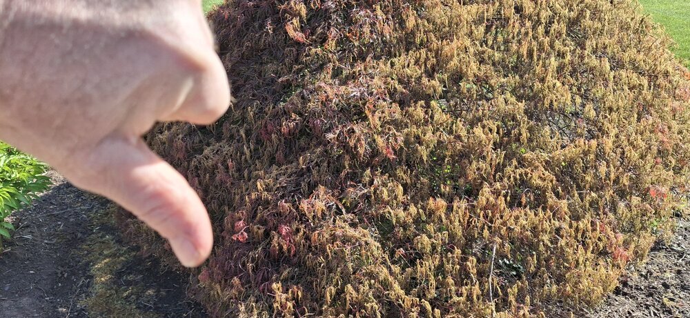
-
Central PA Spring 2026 Discussion/Obs Thread
Yardstickgozinya replied to Voyager's topic in Upstate New York/Pennsylvania
The above was written a few days ago. The main abortions of fruitlits has been occurring for the last three days. -
Central PA Spring 2026 Discussion/Obs Thread
Yardstickgozinya replied to Voyager's topic in Upstate New York/Pennsylvania
https://extension.psu.edu/pennsylvania-tree-fruit-phenology-report-april-21-2026/ Frost Ring Formation Throughout much of the state overnight between April 20-21, temperatures posed a serious risk to fruit crops. Apple, peach, and pear crops may have experienced varying levels of damage depending on developmental stage and site-specific conditions. Apples are at petal fall in Adams County and at full bloom in Center County. Although fertilized flowers and young fruitlets are less sensitive to freezing temperatures than blossoms at full bloom, exposure to critical temperatures may have resulted in tissue injury, leading to embryo damage, fruitlet abortion, or subsequent quality defects. There was also potential for frost ring formation under the forecasted conditions -
Central PA Spring 2026 Discussion/Obs Thread
Yardstickgozinya replied to Voyager's topic in Upstate New York/Pennsylvania
I knew it was going happen before it did. It wasn't just about the freeze.It was also about the stage of fruit development. -
Central PA Spring 2026 Discussion/Obs Thread
Yardstickgozinya replied to Voyager's topic in Upstate New York/Pennsylvania
I apologize if it's already been talked about. I'm haven't been stopping around the forum too much lately. Many fruit farms are reporting 100% loss of fruit as of today from the last freeze. I myself also lost everything. The last freeze did turn out to be locally, one of the most agricultural devastating freezes since i've been a member here. -
Central PA Spring 2026 Discussion/Obs Thread
Yardstickgozinya replied to Voyager's topic in Upstate New York/Pennsylvania
Absolutely, I saw that in the discussion today, pray for clouds and wind. -
Central PA Spring 2026 Discussion/Obs Thread
Yardstickgozinya replied to Voyager's topic in Upstate New York/Pennsylvania
This isn't the usual freeze hype . Tonight's the real deal and a very concerning situation for local fruit farmers. Any amount of time at or below 28°F will be catastrophic to local fruit farming. Cherry and apple fruitlets have already developed. Fruitlets go from alive and well at 29°F to complete cellular damage and abortion at 28°F. -
Central PA Spring 2026 Discussion/Obs Thread
Yardstickgozinya replied to Voyager's topic in Upstate New York/Pennsylvania
.51" -
Central PA Spring 2026 Discussion/Obs Thread
Yardstickgozinya replied to Voyager's topic in Upstate New York/Pennsylvania

-
Central PA Spring 2026 Discussion/Obs Thread
Yardstickgozinya replied to Voyager's topic in Upstate New York/Pennsylvania
Wednesday's convective outlook. Slight risk sneaking into north and west central pennsylvania. https://www.spc.noaa.gov/products/outlook/day2otlk.html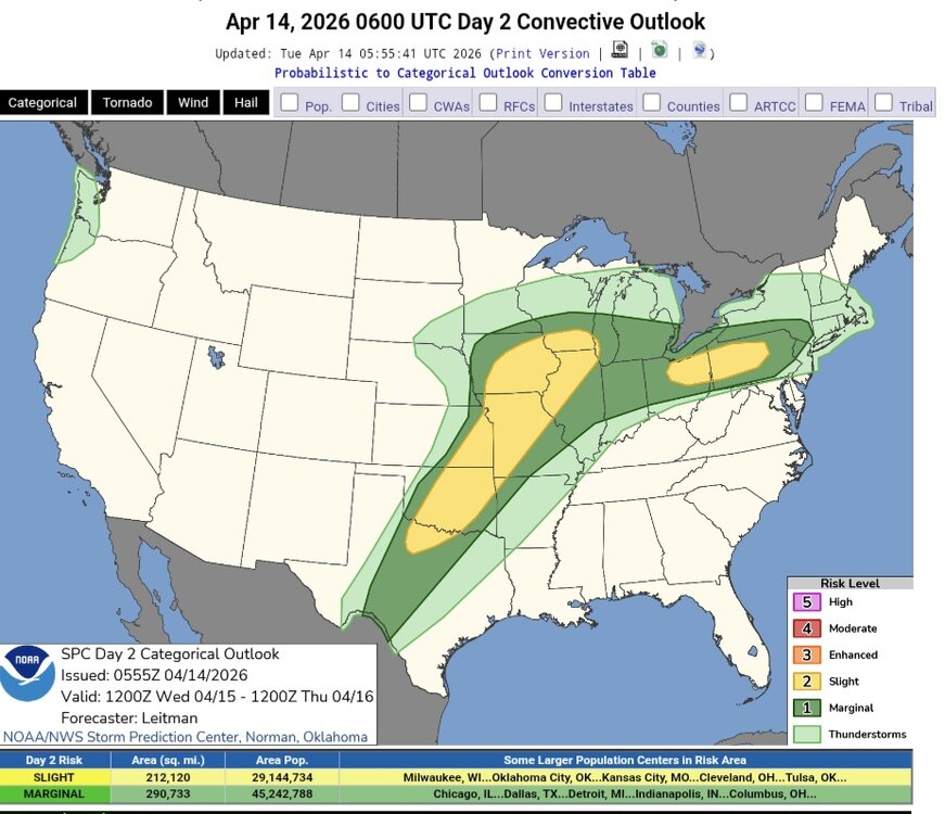
-
Central PA Spring 2026 Discussion/Obs Thread
Yardstickgozinya replied to Voyager's topic in Upstate New York/Pennsylvania
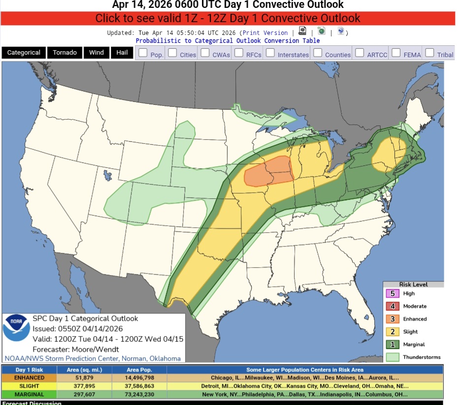
Today's convective outlook. https://www.spc.noaa.gov/products/outlook/day1otlk.html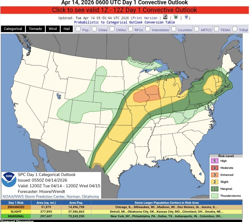
-
Central PA Banter (Banter Less?) Thread
Yardstickgozinya replied to Itstrainingtime's topic in Upstate New York/Pennsylvania
The animagraffs youtube channel is awesome. This is the Big Boy. -
Central PA Banter (Banter Less?) Thread
Yardstickgozinya replied to Itstrainingtime's topic in Upstate New York/Pennsylvania
For anyone who doesn't know, this articulated 4-8-8-4 is not just the god of all steam engine, but it's the god of all mechanical creations, and everyone, and everything should be bowing to it except for god himself. -
Central PA Banter (Banter Less?) Thread
Yardstickgozinya replied to Itstrainingtime's topic in Upstate New York/Pennsylvania
I don't think there's probably any better time for you to start that project than now. I had a very nice platform for years, but I took it down so that I could have room to start building custom fishing rods. I've been trying to devise a way that I can set my platform back up and also have room for building rods. If it's something then you decide to get started on (depending on gauge) I have no shortage of extra track, model coal and foliage that I could pack up and send to a p o box. The tracks have built up a little bit of surface corrosion over the years so they would need some cleaning before they can conduct properly. -
Central PA Spring 2026 Discussion/Obs Thread
Yardstickgozinya replied to Voyager's topic in Upstate New York/Pennsylvania
Entropy should probably be saved for another forum. Lol -
Central PA Spring 2026 Discussion/Obs Thread
Yardstickgozinya replied to Voyager's topic in Upstate New York/Pennsylvania
I know you already know this, but until 13.8 billion years ago absolute zero was the rule, and thermodynamics was the anomaly. Nothing is efficient at heating itself and there's no getting around it. -
Central PA Banter (Banter Less?) Thread
Yardstickgozinya replied to Itstrainingtime's topic in Upstate New York/Pennsylvania
It's funny that you mentioned this. For years I have wanted to paint and mechanically restore a custom passenger diesel and cars, specifically dedicated do everyone on our thread. I'm going to start that project this fall and you guys are going to love it when it's done. The cpa weather express is coming this winter.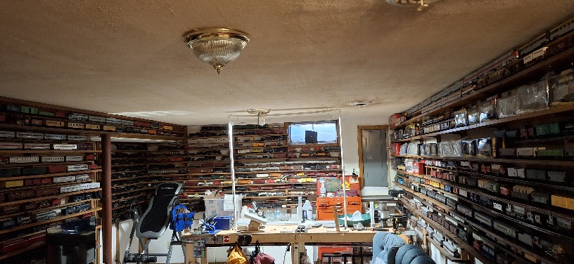
-
Central PA Banter (Banter Less?) Thread
Yardstickgozinya replied to Itstrainingtime's topic in Upstate New York/Pennsylvania
I'm not sure if you're familiar with Autism and trains. lol you have to forgive my messy basement but I might like trains just a little bit . I got just a few on my walls. Some of my nicer steam engines are back on the left corner, I also probably have over a hundred diesels and steam engines that still need restored packed away in my crawl space. I immensely appreciate both real and toy trains and think they are the most beautiful and interesting marvels of engineering humanity will ever create.
-
Central PA Spring 2026 Discussion/Obs Thread
Yardstickgozinya replied to Voyager's topic in Upstate New York/Pennsylvania
I've noticed, and i've been pulling for you. It's great you're seeing a doctor. I have no idea what's wrong with you, but I can tell you that depression and anxiety go hand in hand. Its the anxiety that can have profound and completely unexpected effects both mentally and physically. I only say this because I'm sure you have a lot of worry about what the f*** is going on which is only compounding what is going on . You know, man, if you ever feel helpless and trapped i'm only a pm away. -
Central PA Spring 2026 Discussion/Obs Thread
Yardstickgozinya replied to Voyager's topic in Upstate New York/Pennsylvania
I just got woken up to what sounded like my roof about to get yanked off my house. The wind almost never wakes me up.That had to be one hell of a gust. -
Central PA Spring 2026 Discussion/Obs Thread
Yardstickgozinya replied to Voyager's topic in Upstate New York/Pennsylvania
Not trying to be a jerk here.but he forgot a lot. That said, i'm sure as we get closer, Dt will be quite informative.