.jpg.93eb8afe5d1df4d67bc0eeb78d645380.jpg)
.jpg.7cbeb4b469bd18d447fac5868c43a091.jpg)
Yardstickgozinya
-
Posts
1,230 -
Joined
Content Type
Profiles
Blogs
Forums
American Weather
Media Demo
Store
Gallery
Everything posted by Yardstickgozinya
-
.thumb.jpg.6a4895b2a43f87359e4e7d04a6fa0d14.jpg)
Central PA Winter 25/26 Discussion and Obs
Yardstickgozinya replied to MAG5035's topic in Upstate New York/Pennsylvania
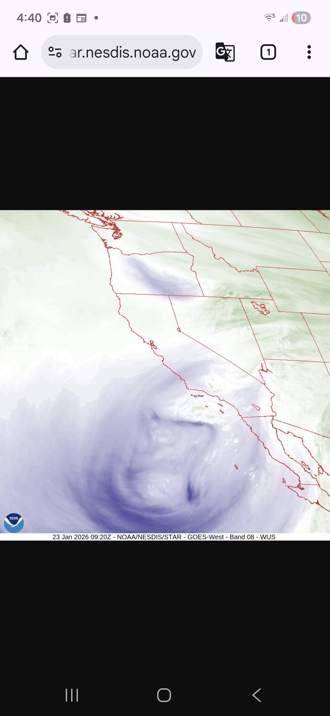
I posted a picture this morning of the air mass descending. It looked quite impressive -
Central PA Winter 25/26 Discussion and Obs
Yardstickgozinya replied to MAG5035's topic in Upstate New York/Pennsylvania
My best buddy in lLisburn is a a topo junkie too. Check out Topo ranger on youtube. He's just a geo weenie that goes around to different local sites of geographic importance. I enjoy his videos, especially on the lower Susquehanna. -
Central PA Winter 25/26 Discussion and Obs
Yardstickgozinya replied to MAG5035's topic in Upstate New York/Pennsylvania
@Mount Joy Snowman.Maybe you didn't realize the proximity fused thing was my light, harted way of me asking you a question. What's your plans with my elevation or were you just more or less just curious ? -
Central PA Winter 25/26 Discussion and Obs
Yardstickgozinya replied to MAG5035's topic in Upstate New York/Pennsylvania
Proximity fuse settings ? -
Central PA Winter 25/26 Discussion and Obs
Yardstickgozinya replied to MAG5035's topic in Upstate New York/Pennsylvania
I find it interesting that nws did not update their forecast discussion yet this morning, This is unusually late. Waiting on additional data is my guess. -
Central PA Winter 25/26 Discussion and Obs
Yardstickgozinya replied to MAG5035's topic in Upstate New York/Pennsylvania
This is where I start getting giddy, quantifiable images. The gods are bowling
-
Central PA Winter 25/26 Discussion and Obs
Yardstickgozinya replied to MAG5035's topic in Upstate New York/Pennsylvania
She's starting to come together. -
Central PA Winter 25/26 Discussion and Obs
Yardstickgozinya replied to MAG5035's topic in Upstate New York/Pennsylvania
Well, I'm not trying to be a dick, buddy. but a lot of these guys here aren't going to take kindly to the back and forth between me and you with a event of this nature coming into the short range. I don't know exactly what defines a blizzard but at this point the national weather service is either not seeing or are anticipating we meet the criteria. Furthermore if they are going to put out a blizzard warning, they have to be confident that they know where the criteria will be met. Once that's pinned down., maybe we'll see something like that somewhere. As far as duration no one can give you an accurate answer on that yet with this particular storm. -
Central PA Winter 25/26 Discussion and Obs
Yardstickgozinya replied to MAG5035's topic in Upstate New York/Pennsylvania
I decided to go ahead and post the rest of the the discussion I'm thinking some of you fellas might like it archived here. Now if you really enjoy meteorology and want to know *why* we are predicting the most significant accumulations in the past 5+ years, feel free to read on through the remainder of this KEY MESSAGE 2 discussion. We`ve had our fair share of cold snaps this winter season, and tomorrow (Friday) will be no exception after the next Arctic front pushes through. A large factor driving all this cold weather has been the Polar Vortex displaced from the North Pole, with a tendency for the vortex to find itself over Hudson Bay and northern Quebec. With displacement that far south, we`ve gotten plenty of cold air, but it`s also nudged the storm track south of our area for many of the recent events. If you`ve ever heard people say "it`s too cold to snow", it`s not that it`s physically too cold to snow, it usually just means that the storm track has shifted far enough to the south that we end up under dry high pressure while our temps are cold. One key difference this time is the influence of a Pacific storm, located off the coast of southern California this evening, and a strengthening subtropical jet to its south. Over the next 24 hours these features will cross the Baja Peninsula of Mexico and then into Texas. Southwesterly flow out ahead of this southern stream feature will pump warmer air into the Gulf Coast and Southeastern US Saturday night into Sunday. At the same time, a northern stream shortwave trough coming down from western Canada into the Great Plains will bring a reinforcing shot of cold air to the back side of the northern longwave trough. The increasing temperature gradients will result in an overall increase in wind speed aloft at jet stream altitude, and an amplification of the northern stream trough and ridge. By Sunday, the right entrance region of the northern jet and the left exit region of the southern jet will align to produce enhanced upward motion through the troposphere. Remaining uncertainty in the forecast largely depends on the degree of phasing of these two jets, the angle at which they align, and how much amplification there is of the ridge out ahead of the deepening trough. The very cold air in place ahead of this system also plays other crucial roles to increase impacts. At 00Z Sunday, model consensus depicts a 1040+ mb high over New York State, which only slowly moves northeastward across New England over the next 24 hours. The deep, cold blocking high to the northeast of a winter storm is a textbook feature that supplies a stream of cold air down the Alleghenies and provides a cold dome for warmer, less dense air parcels streaming in from the southwest to ascend over. That upward motion is key to production of hydrometeors - in this case snow. And then there is the key role that cold temperatures have on ice crystal habits. The so called "dendritic growth zone" exists where temperatures are between roughly 0F and 10F. Given low temperatures Saturday night in the single digits, some spots might start off with a DGZ that extends from the ground up 10,000 to 15,000 feet which is pretty remarkable for a large synoptic storm in this region. As long as the column saturates quickly enough, any snow that falls late Saturday night and into early Sunday morning could be very high ratio, fluffy, rapidly accumulating snow that consists of many pristine dendrites (SLRs 15-20:1, could be even higher if the column saturates faster but there is dry air at low levels to overcome at onset). So after a few hours of virga, accumulations have the potential to begin with a vengeance in the predawn hours Sunday, especially from I-80 south. KEY MESSAGE 3: Arctic blast persists with frigid temperatures and subzero wind chills expected next Monday all the way through next weekend. A prolonged stretch of frigid temperatures continues next week through the end of January (next weekend). After the cold snap Fri night - Sat, the next round of cold wx headlines (-10 to -20F wind chills) is likely Monday night through Tuesday morning. Given the prolonged nature of the bitter cold, we may begin to see more infrastructure impacts (frozen pipes) by next week. Occasional lake effect/upslope snow showers are likely next week under a very cold cyclonic flow aloft. -
Central PA Winter 25/26 Discussion and Obs
Yardstickgozinya replied to MAG5035's topic in Upstate New York/Pennsylvania
Another forecast discussion should be available in about an 1.5 hours, but I still feel this was a pretty interesting read, with a lot more explanation then generally seen. It's a very lengthy discussion, so I only posted part of it here, the rest will be in the link if anybody wants to read it before the next update. 436 FXUS61 KCTP 230420 AFDCTP Area Forecast Discussion National Weather Service State College PA 1120 PM EST Thu Jan 22 2026 .WHAT HAS CHANGED... * Increasing chances for heavy snow this weekend. More details provided in discussion section. && .KEY MESSAGES... 1) Frigid temperatures and dangerous wind chills expand from northwest to southeast Friday afternoon into Saturday morning 2) Increasing odds for double digit heavy snow accumulation and widespread moderate to major winter storm impacts Saturday night through Monday morning, heaviest on Sunday. 3) Arctic blast persists with frigid temperatures and subzero wind chills expected next Monday all the way through next weekend. && .DISCUSSION... KEY MESSAGE 1: Frigid temperatures and dangerous wind chills expand from northwest to southeast Friday afternoon into Saturday morning.Arctic air is poised to return to the forecast area - filtering in from northwest to southeast through Friday night. High confidence in -10 to -20F wind chills across all of central PA Friday afternoon into early Saturday morning approaching extreme cold criteria in the Laurel Highlands. Frigid Arctic air will remain in place prior to the onset of the significant winter storm this weekend. KEY MESSAGE 2: Increasing odds for double digit heavy snow accumulation and widespread moderate to major winter storm impacts Saturday night through Monday morning, heaviest on Sunday. Snow accumulations will likely begin with a vengeance from south to north in the predawn hours Sunday. Periods with snowfall rates greater than 1 inch per hour are becoming increasingly likely in the isentropic ascent early Sunday and as low and midlevel frontogenesis becomes stronger later in the day and evening. Given the dry, fluffy snow and wind gusts of 15-30 mph, there will likely be some blowing and drifting. There could be a period of sleet especially across the southern tier Sunday evening cutting into snow totals just a bit, but not before double digit accumulations are expected to fall.While warm advective, front-end snow is becoming increasingly likely, there is considerable model uncertainty with the placement of a comma head area of snowfall as a secondary low pressure system develops offshore (in a Miller B type evolution). If the comma head sits over central PA Sunday night, several additional inches of accumulation are possible. However, if it misses us to the north and we see more of a dry slot, that would result in snow ending sooner Sunday evening with less accumulation overnight. All in all, the probability of snowfall amounts exceeding 12inches has increased to 60-80 percent across much of central PA. The probability of more than 18 inches ranges from 15 to 40 percent. Amounts near 24 inches can`t be ruled out (10 percent chance) especially if the comma head sits over central PA Sunday night. Always prepare for the worst case scenario and continue to check the forecast as it evolves. Now is the time to prepare. Think snow blowers, re-arranging travel plans to avoid travel during the storm, what to do in case of a power outage, etc. Remember it will be very cold before, during and after the storm. Never run a generator indoors due to carbon monoxide. Now if you really enjoy meteorology and want to know *why* we are predicting the most significant accumulations. https://forecast.weather.gov/product.php?site=CTP&issuedby=CTP&product=AFD&format=CI&version=1&glossary=1&highlight=off -
Central PA Winter 25/26 Discussion and Obs
Yardstickgozinya replied to MAG5035's topic in Upstate New York/Pennsylvania
Diddy lube. -
Central PA Winter 25/26 Discussion and Obs
Yardstickgozinya replied to MAG5035's topic in Upstate New York/Pennsylvania
To say that, I'm expecting a lot less than my 19.3 is an overstatement In reality, I'm still expecting an extremely nice to maybe even historic event. -
Central PA Winter 25/26 Discussion and Obs
Yardstickgozinya replied to MAG5035's topic in Upstate New York/Pennsylvania
My total I went with is a lot higher than my actual expectation. It's more of a gamble and what I want. This may be another controversial statement, but I would be perfectly happy with nineteen inches less than what I went with. That's how much I really love the snow man. -
Central PA Winter 25/26 Discussion and Obs
Yardstickgozinya replied to MAG5035's topic in Upstate New York/Pennsylvania
I do wanna correct what I said. I should have said mitigate accountability. -
Central PA Winter 25/26 Discussion and Obs
Yardstickgozinya replied to MAG5035's topic in Upstate New York/Pennsylvania
If I wanted to get the public to do my dirty work and negate, any accountability that's exactly how I would do it. -
Central PA Winter 25/26 Discussion and Obs
Yardstickgozinya replied to MAG5035's topic in Upstate New York/Pennsylvania
The bomb always in the long range has gotten a little suspicious for the last decade. -
Central PA Winter 25/26 Discussion and Obs
Yardstickgozinya replied to MAG5035's topic in Upstate New York/Pennsylvania
I'm sure I'll get my share of hot dogs for saying this. Maximizing revenue, boosting the economy it's a new world.You either hype s*** up or lose your viewership two boredom in a scrolling world. Basically, in other words one for social media dumb dumbs another for the hard core w***** like us and Mets. Makes perfect business sense when you think about. -
Central PA Winter 25/26 Discussion and Obs
Yardstickgozinya replied to MAG5035's topic in Upstate New York/Pennsylvania
That's awesome. As soon as you're leaving his home and making a left on to Tall Oak Dr, I'm right in front of you up there on the hill with the two small pickup trucks in the driveway. -
Central PA Winter 25/26 Discussion and Obs
Yardstickgozinya replied to MAG5035's topic in Upstate New York/Pennsylvania
583' -
Central PA Winter 25/26 Discussion and Obs
Yardstickgozinya replied to MAG5035's topic in Upstate New York/Pennsylvania
I live in Timberridge about a half mile from Fairview elementary school. . Not sure If you're familiar with the fellow that owns Gran U lawn, but I live right next door to him . I routinely. walk down to the Giant but it's not really considered walking distance by most people. I'll definitely be heading down to Rutters, but the storm will dictate when I eat, sleep, walk, and s***. I'll keep you posted buddy. -
Central PA Winter 25/26 Discussion and Obs
Yardstickgozinya replied to MAG5035's topic in Upstate New York/Pennsylvania
19.3 Might as well put it in the front page already. Are you going be in the area overnight, Sat, Sun , Mon -
Central PA Winter 25/26 Discussion and Obs
Yardstickgozinya replied to MAG5035's topic in Upstate New York/Pennsylvania
Hey let's make sure we're coming at the new members correctly so this can be a fun storm for everybody. -
Central PA Winter 25/26 Discussion and Obs
Yardstickgozinya replied to MAG5035's topic in Upstate New York/Pennsylvania
The floridians and their warm bias have corroded his mind, there's no saving him now. -
Central PA Winter 25/26 Discussion and Obs
Yardstickgozinya replied to MAG5035's topic in Upstate New York/Pennsylvania
Yeah, but they also said dream on -
Central PA Winter 25/26 Discussion and Obs
Yardstickgozinya replied to MAG5035's topic in Upstate New York/Pennsylvania
Yeah, I mean, the guys are right that warm air can be a b**** but really anyone's guess at this point .But yeah, i'm kind of riding that same crazy train as you. Although on my train sleet and pingers are the same thing.