

MDScienceTeacher
-
Posts
164 -
Joined
-
Last visited
Content Type
Profiles
Blogs
Forums
American Weather
Media Demo
Store
Gallery
Posts posted by MDScienceTeacher
-
-
7 hours ago, Plow'n said:
I make a living off of snow, from bwi to dca so I have a hard time understanding some of these "hard times" over snow models. If it's a hobby, I get it. I'm here to learn and get a "non-hyped" 3rd party opinion from independent meteorologists who I mentioned above
Not true.. you are here because your sick like the rest of us.
-
 2
2
-
-
On 1/11/2024 at 9:52 AM, mattie g said:
Yes. If you park in long-term parking, you need to take the shuttle to the terminal. Depending on the time of day and which stop you get picked up at, it can take anywhere up about 15 minutes to get to the terminal once you get on the shittle.
Pretty sure they run 24/7, or at least as often as they need to get people to the terminals on time.
So I get stuck in Chicago overnight because i missed my connection due to the snowstorm. I thought… hey no problem I will a get a treat of a foot of snow before continuing on.
well sure as shit as soon as my plane touched down the snow turned to rain, it never flips back and Chicago busts HARD with only 2 inches of slush on the ground.
-
1
-
-
5 hours ago, stormtracker said:
What a dumb hobby. Why did we all get cursed with this? Get this...there are sickos out there who don't care if it snows or not. They have no concept of weather. They go about their day and check an app maybe once or twice a week. And if a storm doesn't come...they are un phased. What must that be like? Have yall thought about these people? They are amongst us and they are in way bigger numbers.
Every male in my direct family watches the models and follows storms… I got them in to it and now I feel guilt about
-
I guess my retirement vacation just got a lot more interesting and I lucked in to a snow storm today. My flight to Hawaii was delayed because the connecting flight was out of Chicago. The connecting flight to Honolulu left already so I needed to rebook the same flight tomorrow morning. Getting ready now to take off (finally). Long story short:
I will be spending the night at a Hilton in Chicago tonight. I am pretty sure it will be near Blizzard conditions with a fluffy 12 inches by morning:
-
 5
5
-
-
Need Advice from a DC Local.. whats the deal with flying out of Reagan and long term parking? If I have a 7:00 AM flight and need to park long term, like do I need to park and then take a shuttle? Will shuttles be running at 4:00 AM? My Hawaii Retirement Celebration starts tomorrow and because of the Boeing 737 Max 9 grounding I am now flying out of Reagan.
-
2 hours ago, Random Chaos said:
If we get this height (5.5 feet above MLLW), yes. The next highest was October 2021 at 4.88 feet above MLLW. Isabel was 7.20 feet above MLLW. There were two other storms in the past 100 years to breach 4 feet - 1950's and 1930's
Annapolis Isabel: https://tidesandcurrents.noaa.gov/waterlevels.html?id=8575512&units=standard&bdate=20030915&edate=20030923&timezone=GMT&datum=MLLW&interval=h&action=
Annapolis October 2021: https://tidesandcurrents.noaa.gov/waterlevels.html?id=8575512&units=standard&bdate=20211026&edate=20211104&timezone=GMT&datum=MLLW&interval=h&action=
Thank you for this! I had a boat in Bowley's Quarters during Isabell. The marina stayed up all night long retying lines to prevent the lines from sinking the boats. They did a really great job.
the next morning I had to walk out on the pier that was still 2 feet under water just to get to my sailboat. That was a crazy event. -
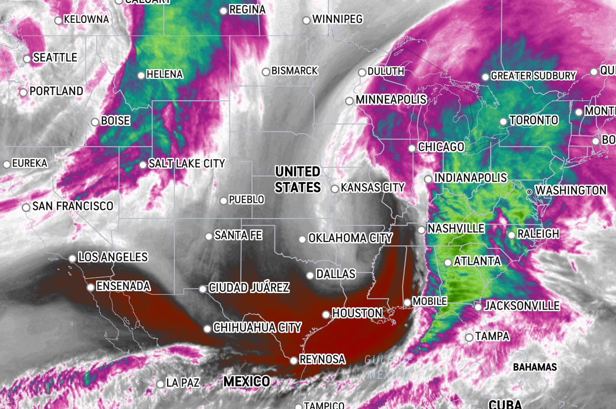
Completely different set up, but not nearly as impressive as the March 2019 event on the satellite view. Wondering how much hype this is compared to the past events.
Today:
March 2019: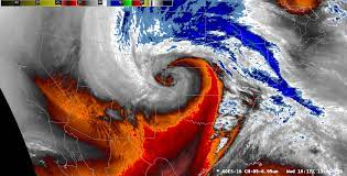
-
13 minutes ago, Random Chaos said:
New tide forecast out. It's higher than the previous one yet again, by about 2-3".

Will this be the largest surge event since Isabell?
-
1
-
-
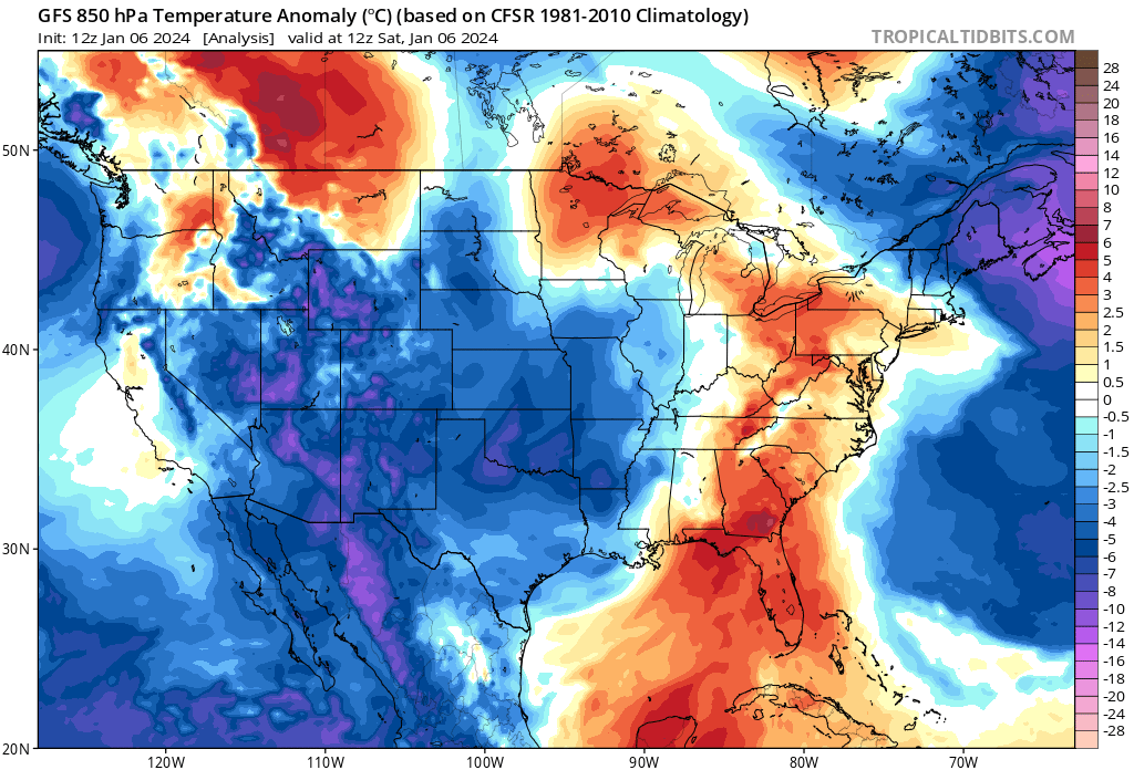
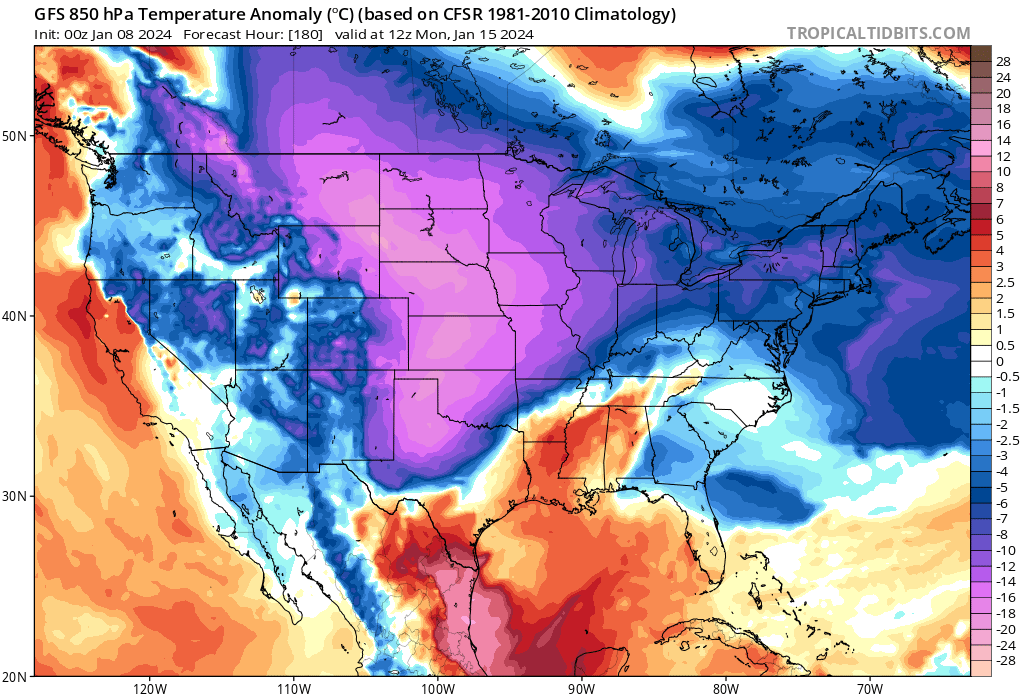
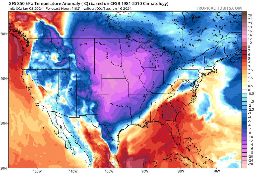
2 hours ago, Heisy said:
Ah yes, I had a good feeling we’d wake up with one weenie run after seeing the 18z EPS.
We need to keep the TPV here in SE Canada there, if it migrates W we lose the cold and heights will pump N in the Southeast
As is it’s almost perfect, snows in the 20s. Perfect overrunning event long way to go lol
.yeah the it should be much colder leading in to this period. Here was the 850 Temp Anomaly right before our weekend storm that was just a tad too warm:
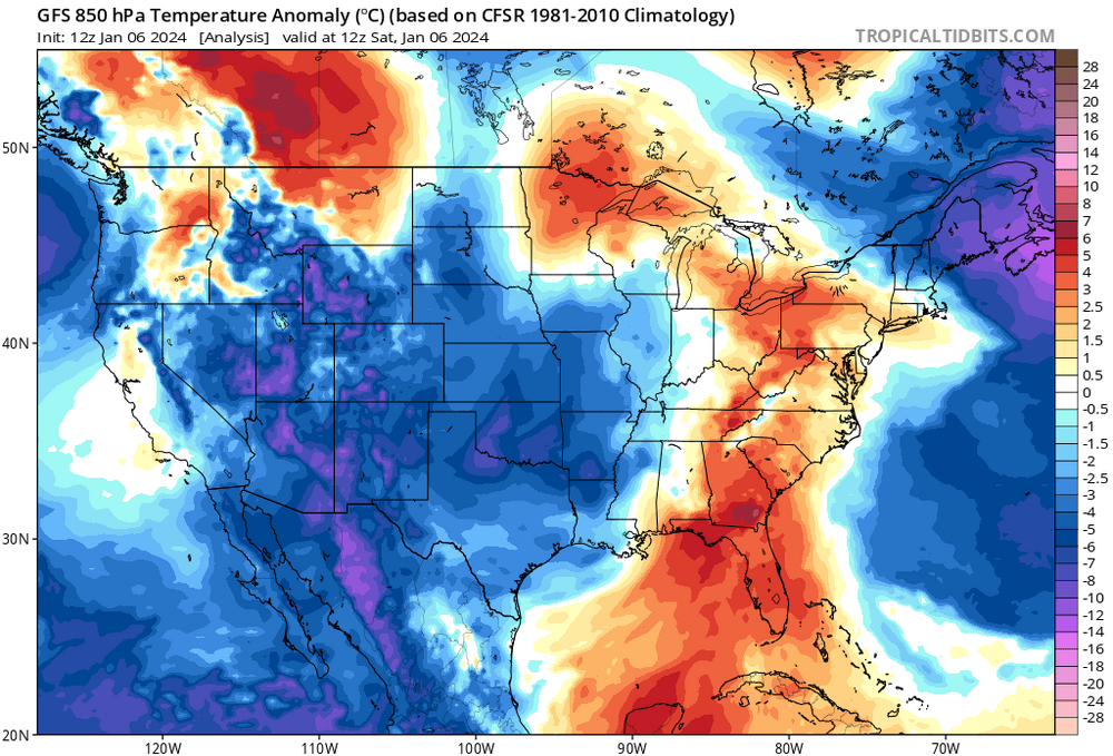
Now compare that to the upper level temps leading in to the Jan 16th period:


-
2
-
-
On 1/5/2024 at 9:52 AM, ers-wxman1 said:
The pattern is missing key features that would generate a solid winter storm not just for the MA but for the Northeast as well. How many arctic intrusions with wind chill headlines and sub zero air masses over the northern Plains and Great Lakes this season. None. Very abnormal to see this over an extended period like we have. Bass boats were being launched on the lakes in Minnesota on 12/27, on a lake where cars normally drive on with thick ice. Something is amiss and yes it would take a larger scale phenomenon to get it to shift.
No mechanisms in place to both drive arctic air in and keep it. Pattern is not amplified like needed. No blocking, no ridging out over the western U.S. we get cool passages with modified air. Not going to get it done. El Niño is only one factor. That just guarantees more southern stream energy, drought going away with ample moisture but it does NOT necessarily mean more snow. No cold air to produce. PSU is correct in his assessment. Going to take a more persistent change or else it’s more of the same.
I agree with everything you say here other than the "something is amiss" comment. It is plenty cold, just not here. While a significant portion of the US has been experiencing above average temperatures and the current snow drought has been historic, it has also been really cold in other parts of the world during this same time period. In fact areas in Asia experienced record breaking cold last winter and this has continued in to Russia and Siberia this year. Here is an article from our old friend @Ian
https://www.washingtonpost.com/weather/2023/12/06/siberia-russia-extreme-cold-asia/
We simply need to wait for our turn and I think, based on the recent guidance, our turn is right around the corner.
-
1
-
-
1 hour ago, NorthArlington101 said:
a good southeast shift on the RGEM and nobody bothered to post it? smh

I guess you are being Sarcastic but I stopped looking at the RGEM a couple of years ago when it called for 60 inches of snow in Lancaster and I chased only to see 7 inches.
-
2
-
2
-
-
56 minutes ago, psuhoffman said:
Depth of the airmass isn’t good enough. Yea we’re cold now because we’re directly under the axis of the northerly flow behind an amplifying wave. But at its zenith the cold barely gets south of us and isn’t expansive so as soon as the return southerly flow hits ahead of the next wave it’s easily scoured out. But hey we’re only 12 days after the long wave flow changed and the pac puke was cut off. . We need at least 3 weeks of a good long wave pattern to have any chance to be cold enough.
Logically what you are saying makes sense, but we have seen torch to a foot of snow many times before. The writing is on the wall for this and sure its gonna be too warm. But to say we need 3 weeks of pattern change just to get a chance of snow makes me think it is almost impossible for the MA to get a snow storm.
Maybe you are saying this just in the context of this set up. -
55 minutes ago, Ralph Wiggum said:
Went from a MA special to Congrats New England in under 18 hrs. That's gotta be some sort of record.
No. I have seen it so many times before. Usually in that exact time range too. This is why I commented on @psuhoffman 's post last night when he was telling @Deck Pic how much the models have improved and how within 6 days its usually just ironing out minor details. If this holds, the GFS was a major bust.
For like 8 runs in a row the GFS was showing a text book MECS. Then all the sudden its QPF was cut in half while the track and intensity decreased dramatically. I cant tell you how many times I have something like this in the exact same time range. I feel like there is no safe lead time around here.
-
1 minute ago, nj2va said:
Any snow is good snow, especially in the mid Atlantic.
@Ji do you concur?
-
2
-
-
2 minutes ago, Chris78 said:
It's going to be a close call for northern areas. 6z Euro control and 12z Gfs runs the rain/ snow line pretty darn close to the M/D line.
Doesn't mean it's correct but with the latest trends you may need to be in central PA to feel secure with this set up.
Yeah.. we will have to wait and see what happens tonight before we know for sure. One thing I dont buy is a weak/ moisture starved system. We have been in a pattern here over the last couple of months of vigorous subtropical jet energy resulting in higher end QPF totals and overall stronger/ more dynamic storms.
Temperatures are a valid concern, however I really think that what we get QPF wise will be greater than what was shown in the 12 GFS.
-
2
-
-
4 hours ago, psuhoffman said:
lol. We are not locking anything in. But I will say I’ve observed in the last few years since the major upgrades to the gfs and euro, there is a pattern where they start to narrow in on the general synoptic solution around 140-160 hours out. After that the changes are more subtle. We’re marginal so subtle could be big for our ground truth but once inside day 6 usually it’s not adjustments of 500 miles like it used to be. They even picked up on that crazy anafront wave from 5-6 days out! They still have limitations but since the last upgrade they seem to start identifying the basic idea a couple days earlier than before. I know we haven’t had many chances to test this locally but I’ve tracked storms for my various ski interests over the last few years.
Yeah and we have been burnt really bad on 96 hour leads where all the sudden the entire storm shifts 100 miles on all the guidance all at once. Heartbreak city. This is why I just refuse to go all in any more on anything even with a winter storm warning in effect.
-
1
-
-
2 minutes ago, Deck Pic said:
Climo says 3-6" east of the fall line. If it doesn't completely fall apart.
But it’s a nino in early January with some really nice blocking over the North Atlantic. I think there is a lot more upside.
-
1 hour ago, H2O said:
Two camps right now. Either a weak miller B with temp issues for 95 and NW wins, or Miller A that can shift to have temp issues for 95 and NW wins.
Basically NW wins.
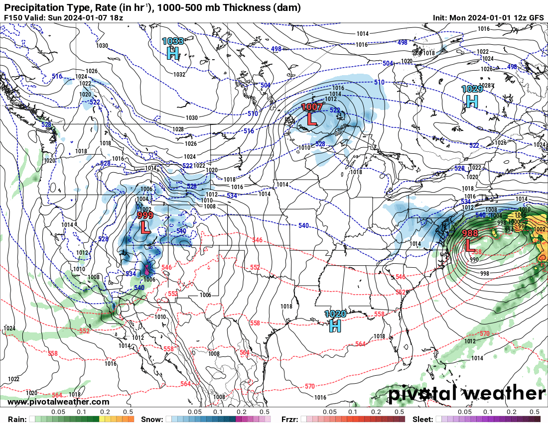
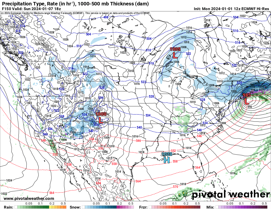
One thing of note is that the GFS doesnt allow the snow to get much north of NYC, with backend banding setting up over the mid atlantic:
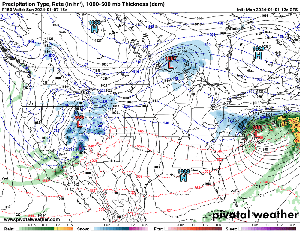
While the Euro is a quick thump to dryslot and it snows all the way up the coast:
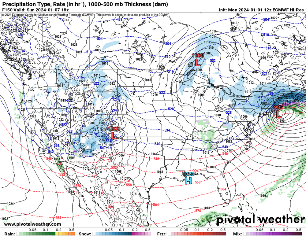 block
block
I am not expert but given our previous experience with these types of setups, I feel like the GFS would be more plausible.
I want to see this storm hit our latitude, stall, pivot and then get crushed by ULL rotating through, that would lead to >18 hours of snow.
-
4
-
-
5 minutes ago, nj2va said:
“Purple has entered the chat”
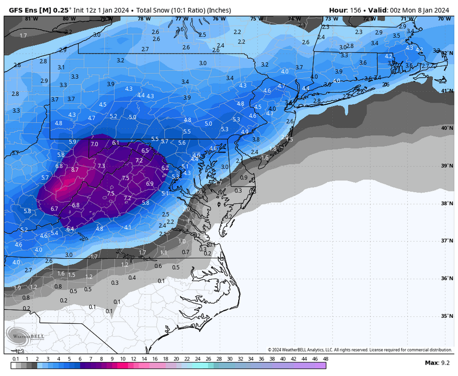
That’s the ensemble too. That is a huge signal if I ever seen one. Just wow.
-
6
-
-
5 minutes ago, nj2va said:
Splitting hairs here but it’s not a week out. Euro gets precip in Saturday evening. Yes, keep expectations in check and go with the ensembles at this range.
Right I was gonna say the same thing. We are in the 5 day range.
-
2
-
-
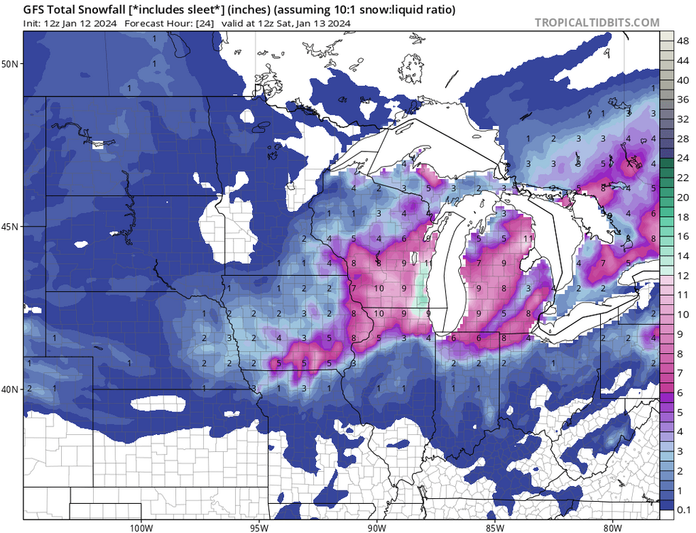
The differences in the 500 MB Height Anomaly North and East of us btw this mornings 6z run (where we get a nice snow storm) and yesterday's 12Z run (which shows a cutter) are significant. Notice how the low heights extend all the way in to the Hudson Bay on the 6z. My guess is this acts to strengthen the block, locking in HP to our north causing a tighter pressure gradient and keeping the upper level low from tracking too far north before spawning the surface coastal low. Quite different than the 12Z yesterday where you can see a upper level low pressure extending up in to Chicago (way too far north).
6Z today:
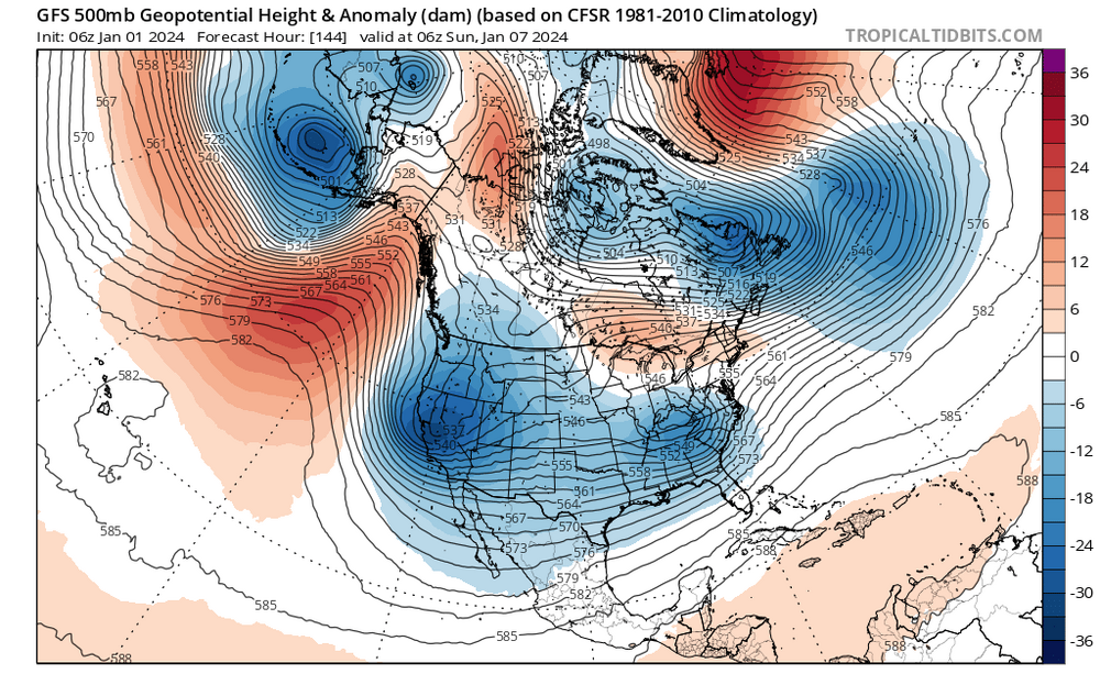
12Z yesterday: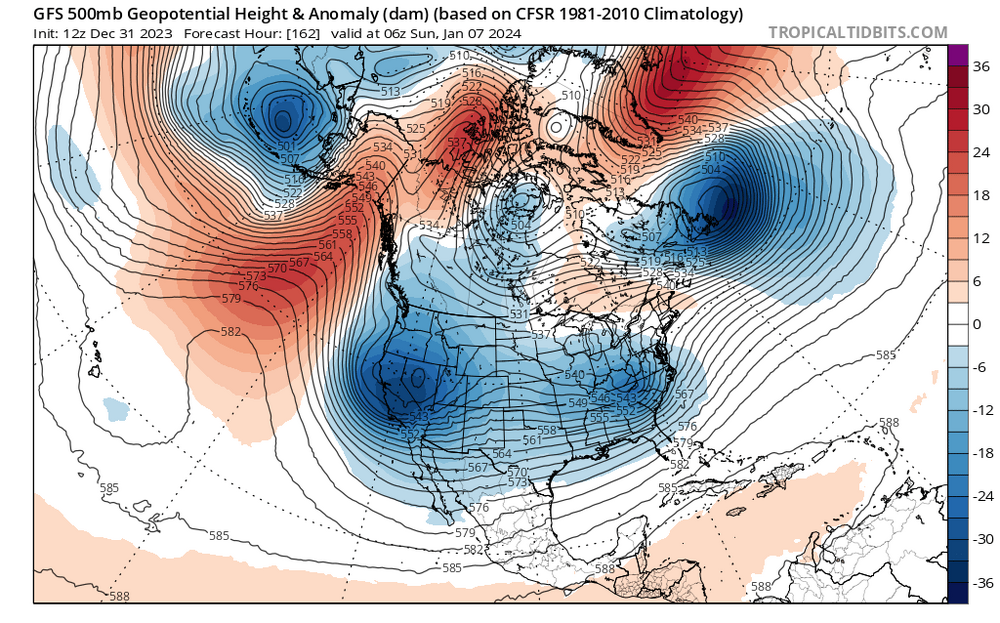
-
4
-
-
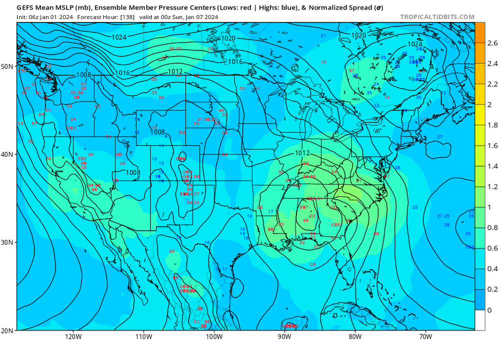
The EPS looks to have more certainty in the storm track for this storm (members are more clustered together):
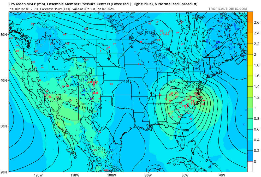
GEFS:
-
2
-
-
2 hours ago, Eskimo Joe said:
I don't care what others say, until the southern jet feature is inside the North American RAOB network, wild swings occur. During the Dec 2009 snowstorm, there was a RAOB site (New Orleans?) that was launched late and they didn't get in for the 00z GFS. The result was a dry looking 00z GFS/GEFS that freaked a lot of people out. Thankfully someone here caught it in the NCEP model diagnostic disco (I think it was either you or @WxUSAF). Color us shocked when the 12z GGS/GEFS snapped back to a big storm.
I just learned that "NWS takes observations at 92 stations; 69 in the conterminous United States, 13 in Alaska, 9 in the Pacific, and 1 in Puerto Rico. " What other sources of data does NOAA feed in to the GFS? Especially on the west coast where there are only 9 stations in the pacific.
-
59 minutes ago, Heisy said:
18z gefs def a lot better with confluence
.In addition, the cluster of lows on the individual members lot shifted south and west by about 75 miles:
12Z
18Z
-
3
-


Jan 15-16 Storm Threat Thread: The Return of Hope??
in Mid Atlantic
Posted
No