

MDScienceTeacher
-
Posts
164 -
Joined
-
Last visited
Content Type
Profiles
Blogs
Forums
American Weather
Media Demo
Store
Gallery
Posts posted by MDScienceTeacher
-
-
3 hours ago, yoda said:
Looks like 06z GEFS is going the offshore route at 168
Per the op, sub 990 low going over Central VA under an air mass that has been historically warm means temp issues. Not saying it couldnt happen, we have the 50-50 low so that should help to fight the warm air, I am just saying dont invest too much in to this storm until we get closer.
One silver lining is that the GEFS shows a much different track, with the low pressure bombing out after it exits the coast: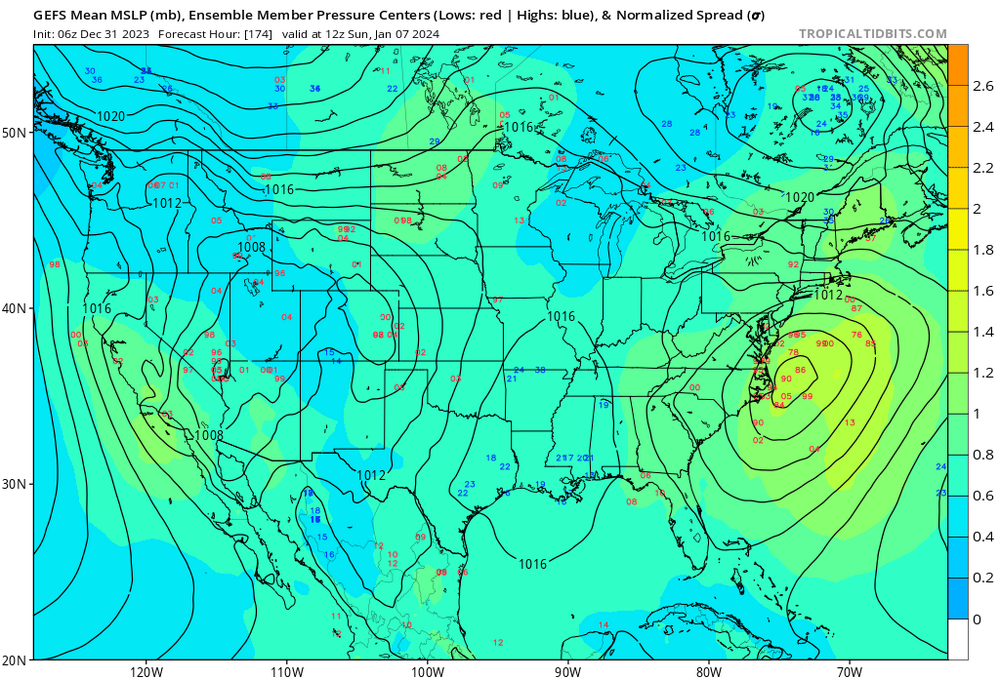
-
 2
2
-
-
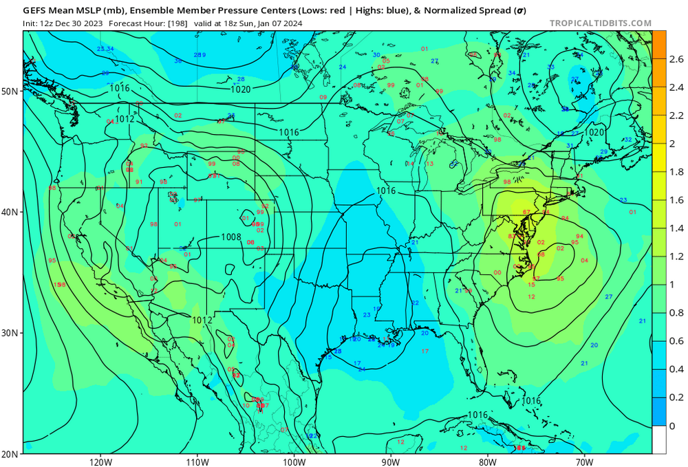
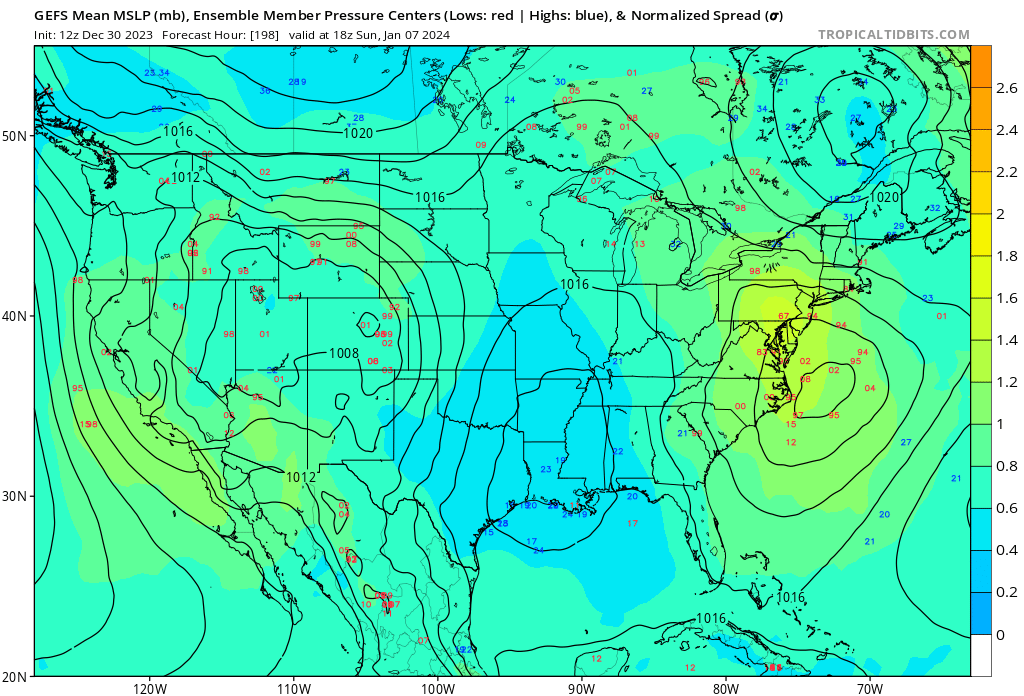
Here are the individual Ensemble Members for the 7th. This is noticeably north of the previous three runs. Good Cluster of lows. Not sure if it will be cold enough.
-
8
-
-
1 hour ago, fujiwara79 said:
you don't need to search too hard. the answer is staring you in the face. Underwater volcanos!
Yes. Volcanic activity (large and small scale) can lead to significant exothermic processes. Definitely enough to have an impact on world wide climate. I dont think people realize just how much energy it takes to skew the earths natural Glacial-Interglacial Cycles, things like volcanic activity, sun spots and astroid strikes are all capable of changing the earths weather patterns.
But honestly, we are probably just in a slump and we will wind up getting a 50 inch season sometime very soon.-
1
-
-
8 hours ago, psuhoffman said:
I agree with the CC point. Wrt this winter I want to get more snow from this next window also but I wouldn’t rule out still going epic even if it doesn’t start until late January. Week SPV, Nino, -qbo the ingredients are there to go on an absolute tear if we can just time things up. We can hit climo in one storm in a Nino. Then all we need are a couple other hits and we get into memorable season territory. 1958, 1966, 1987, 2010 all had epic runs post Jan 20. So long as we see the seeds being laid, nao going negative mainly…I think we are still ok
One reason is that NWP is better at picking out the major long wave flow at range than discreet surface features. Another is that we can look at an ensemble mean to get an even better idea of the long wave pattern but you can’t do that as effectively with surface features. Plus if you are skilled you’re often better off figuring out what should happen given the long wave pattern at range than relying on the surface details of nwp.
Right.. I dont know if anyone remembers this but the weather channel used to have a segment called "A look ahead" where they would show the jet stream pattern up to 7-10 days in the future. It was a great segment and they used it to warn people ahead of time for snow storm potential. That was probably my earliest memories of following weather models.
-
2
-
-
1 hour ago, psuhoffman said:
Two things can be true. I’m still very bullish on snow this season. But I am also still seeing the same signs of climo degradation. The latter doesn’t mean I’m saying it won’t snow. Maybe we get 40” instead of 50” though. And because I love snow so much it frustrates me when I see even a coating being “stolen” compared to the climo baseline I grew up associating as “normal”.
Take this example. I’ve been visiting a close friend in Vermont. We were discussing the similarity in the recent pattern to 1998 except adjusted for 25 years of warming. It made no difference for DC. They were rain in 1998 and rain now. But Vermont was crushed with snow in all those storms that season. But last week that perfect track storm was rain all the way into Canada. And again in a couple days the next coastal will be rain up here. And before someone says but pac puke, that didn’t used to matter at 2000 feet in Vermont! If you had a 988 low off the benchmark it didn’t matter what the airmass was it was gonna snow here.
Does that mean they aren’t going to get a ton of snow this winter. Of course not. It will still snow plenty. But that doesn’t change the clear indisputable warning signs flashing that it’s getting harder to snow. Both points can exist simultaneously. And I choose to acknowledge them both.
That storm would have been rain during peak climb.. even in to Vermont and New Hampshire. There wasn’t an antecedent cold air mass anywhere on the eastern seaboard. With the same set up you would get the same outcome. Maybe elevation would do a little better but I don’t think people realize how much warm air was pulled in from the that storm.
-
3 hours ago, Ralph Wiggum said:
Someone was talking last night here about how you can't just look at an h5 map blues and reds and assume what the relative weather is going to be. Case in point wrt 6z gfs....looked at h5 and 500v (almost always look here first) and assumed a relative quiet run post Jan 4. However, one of the better fantasy threat systems of the lr shows up on the surface maps after the 6th especially wrt this subforum.
Also I don’t understand why someone has any more confidence in a 264 hour h5 map then they do a surface map at the same tome period. I get it, models are more skilled with longer waves but fantasy is fantasy and anything over 192 hours is fantasyland
-
2
-
-
2 hours ago, Eskimo Joe said:
If you mean surface observations, yes. These are surface stations. We don't have profiles like New York.
When you say "We don't have profiles like New York" does this mean that New York Meso station obs have vertical sampling? And how do they achieve that? Balloons?
Just curious.
-
12 hours ago, Eskimo Joe said:
Merry Christmas, more mesonet sites are online! Our entire network runs on 5 min obs. Thank you @wxmeddler and everyone else on the team for all of their work. You can also view data on our website: https://mesonet.umd.edu/
PS, for any NOAA or Synoptic users, the IDs for each site are at the end of the URL below. If you want soil data, check out the link on the website above. More sites dropping in during 2024.
- Clarksville: https://www.weather.gov/wrh/timeseries?site=001MD
- Frostburg: https://www.weather.gov/wrh/timeseries?site=002MD
- Keedysville: https://www.weather.gov/wrh/timeseries?site=003MD
- Easton: https://www.weather.gov/wrh/timeseries?site=004MD
- Ridgely: https://www.weather.gov/wrh/timeseries?site=005MD
surface only?
-
9 minutes ago, Bob Chill said:
When all guidance starts showing compressed heights in the east oriented WSW-ENE.... I get stoked... I'm pretty stoked

These are the upper level height patterns that can produce snow with just about any wave. Not just a perfectly timed one or second in line or whatever. I know u know this up and down. Just adding to the disco
Is this what you are talking about?
-
1
-
-
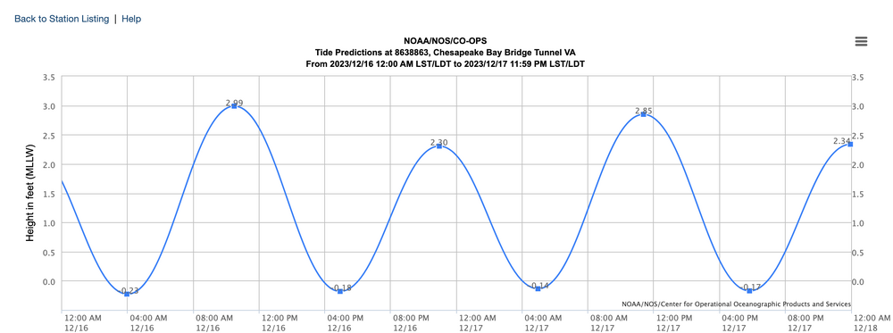
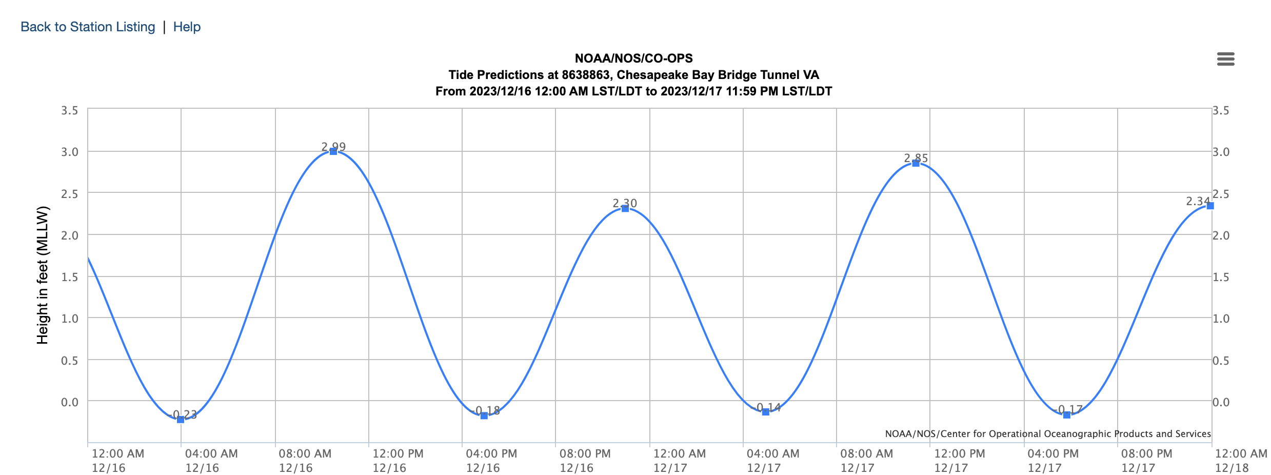
2 hours ago, Weather Will said:
WB 18Z NAM, winds are crazy Sunday night....

High tide is Midnight Sunday night in to Monday. This coincides with the highest winds. Could be a moderate storm surge event for the lower western shore.
-
1
-
-
46 minutes ago, stormy said:
Sunday night, strong LP is over S. Carolina dumping rain.
No 50/50................ Source of cold air way back over North Dakota............................
Are you actually tracking this? I mean its neat to look at and it is cool to get a real deal southern stream system to move through.. but this has been a rain storm ever since it showed up on the models like 7 days ago.
-
2
-
-
Just now, Maestrobjwa said:
To me this isn't worth tracking at all...thread the needle hasn't worked for years. But, to each their own!
Threading the needle implies that there is some level of cold air in place. This is just not that case with the current pattern.
-
 1
1
-
-
59 minutes ago, Wxdavis5784 said:
It won’t happen because Snowman19 is confused.
LOL.. 2 meter temp change run to run. They know who their users are.
-
1
-
 2
2
-
-
7 minutes ago, psuhoffman said:
If the banding being shown does materialize I think a compromise between the Kuchera and the depth maps are more likely.
What did January 2011 look like a a few days before? Didnt that one sneak up on us too?
-
6 minutes ago, Negnao said:
@Ji is this one exciting enough for you?
-
13 hours ago, ldub23 said:
JAN 1994 was chilly in NYC with 3 lows of zero or colder
Maybe this is the beginning of the pattern change. We are not at the beginning of the end but the end of the beginning
The 384 hour GFS is never correct. It can get lucky but never correct. I would recommend picking a time where you can legitimately start taking model out put seriously (like <168 hours ) and dont look at anything after that .
-
1
-
-
21 hours ago, psuhoffman said:
There’s an amped signal for a guaranteed vodka pac puke base state regime…….climate change
Yikes. I know you didn’t see hardly any measurable snow last year and this was far and away the lowest snowfall totals in since records were kept in northern md. The last 20 months have been tough. I think we will be fine though. I would be shocked if our area doesn’t bounce back to the historical average with a season or two producing above average snowfall.
-
2
-
-
1 minute ago, NorthArlington101 said:
Western zones shellacked at 294. Welcome to winter!let’s do this! Btw Isn’t this a legitimate look? Red over Greenland and blue in the Atlantic?
-
3 hours ago, CAPE said:
I suppose it's time for Ji to start a digital snow thread.
I just spent 45 minutes comparing the last 4 runs of the 264 hour + GFS.
it’s gonna be a long winter.
-
1
-
1
-
1
-
-
8 hours ago, BristowWx said:
If it was January with that low track of the GFS for Saturday...there would be some large Bob Chill emojis and the words DC crushed and anihilated would be needed
The next storm turns nw directly in to Delmarva
-
1
-
 1
1
-
2
-
-
Tropical is a high bar.. at least it used to be before NHC started naming ever cluster of thunderstorms producing a gust over 38 mph.. that being said the Mediterranean is not capable of producing tropical storms. This is why these storms are not tracked as such..
The reality of the situation is that the Infrastructure didnt hold in Libya... in order to understand why we would need to go in to the geopolitical realm and thats a no no here.
-
3
-
-
32 minutes ago, Eskimo Joe said:
Special event contingency planning is the bane for local emergency management. Concert organizers refuse to engage and go off into left field in the name of profit. That's not to say that we should bubble wrap everything and cancel at the drop of a shower, but I agree that this appears to be a complete cluster.
Sometimes you need to live a little and let it rip!
In 2013 I went to see Fun. at Merriweather. There was stalled out severe storm that dumped for an hour straight. Lightening everywhere. They kept playing. I was in the field the whole time.
That was the most memorable concert experience of my life...
-
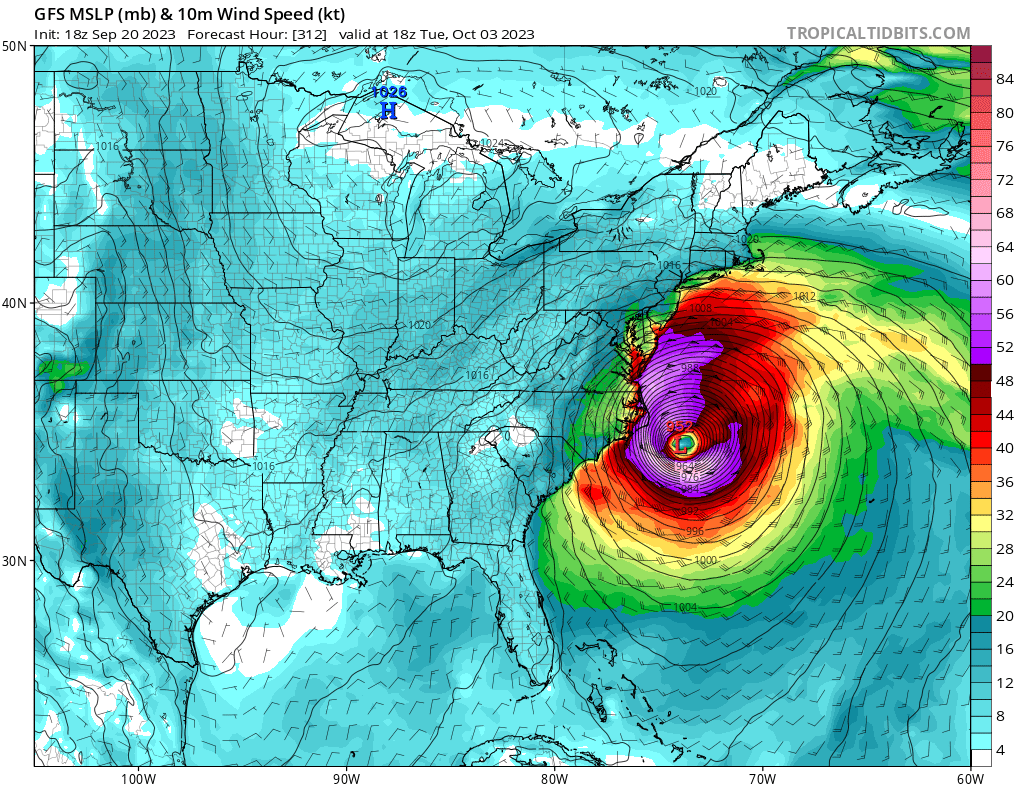
Not trying to downplay what is for sure to be a major disaster with catastrophic flooding in the Southwest.. but Watching WX Twitter go nuts over Hurricane Hillary is amusing.... post after post describing this is some sort of once in a life time event.. you only have to look back to last year to Hurricane Kay with a 100 mph wind gust in San Diego County.
-
On 6/11/2023 at 3:37 PM, bdgwx said:
The current data is interesting to say the least. I've been tracking both the record setting daily SST and daily 2mT. I'm not sure what to think of this. These are such extreme anomalies that they are statistically unlikely to persist even in a warming world so it makes me think they are transient and there will be a reversion to the trend soon.
I have my model updated to better predict near term GISTEMP values. My May GISTEMP expectation is still 1.05 C, but with a much reduced uncertainty of ±0.08 C. And even though the May update isn't even published yet I'm already starting to see a big jump up in the June expectation given the current data. I'm going to go with 1.10 ± 0.16 C for June. And that could be low if temperatures don't come down from the first 1/3 of the month. I'm not going to post the monthly breakdown until the May GISTEMP and June IRI ENSO forecast are published, but a sneak peak of the final 2023 expectation does get bumped up to 1.07 ± 0.09 which puts the odds of a new record at 78%.
What does 1.10 ± 0.16 C mean? Is this the Average Global Temp anomaly for the month of June?

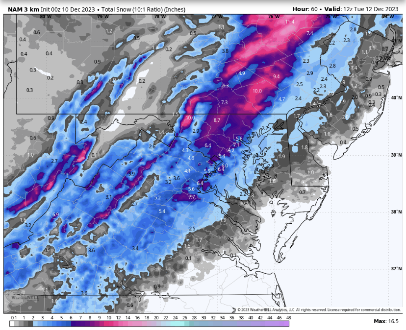
Jan Medium/Long Range Disco: Winter is coming
in Mid Atlantic
Posted
Right. And on the gefs as a result the low pressure tracks over Georgia and out over benchmark. Based on the overall run to run consistency of the blocking to our north and northeast I don’t expect much to change over the next several days. It’s gonna come down to how the minute details play out like how strong the hp is to our north and the timing of when and where the low bombs out to our south.