

MDScienceTeacher
-
Posts
164 -
Joined
-
Last visited
Content Type
Profiles
Blogs
Forums
American Weather
Media Demo
Store
Gallery
Posts posted by MDScienceTeacher
-
-
10 minutes ago, snowmagnet said:
DT yesterday said there was no way the MidAtlantic would get snow next week. So….
And we have this going for us.
-
 3
3
-
 1
1
-
-
5 minutes ago, nj2va said:
Agreed, I think that was a decent enough shift. There’s even been shifts within 100 hours that have been meaningful this winter with our last two events so I don’t think anyone can confidently say they know the final outcome.
If you go back to 12z yesterday it is a huge shift in the right direction so I am happy with this. What we can’t have is the 2 meeting in the middle.. so we basically have 0 wiggle room and are relying on the euro to continue its shift. Fun times for sure.
-
1 hour ago, EHoffman said:
36 on the surface for our heaviest rates lol
I would not worry about it too much. We have seen thunder snow with these types of setups in the past.. as long as we get the rates I am pretty sure the cold air aloft will mix down
-
1
-
 1
1
-
-
Um guys.. not sure if anyone is getting this faster.. but the GFS looks like it might go off again.. could be wrong. but that 1039 HP isnt really budging.

-
1 hour ago, Ji said:
EPS seems to like Post PD more than PD. Feb 21-22. The PSU storm
If memory serves, the first PSU storm was Dec 26 2011.
-
1 hour ago, stormy said:
It's a SLAM DUNK with all 3 on board at 240.
lol
-
1
-
-
53 minutes ago, CAPE said:
Clearly a signal for snow well to our north for that window. Possibility for a little something is there though. And subject to change- we have seen that there is a path to victory on recent op runs.
If the storm track and strength remains the same as what was shown on the 18z I will take my chances with the thermals. There is a lot of potential with this one.. I would not be surprised if we were looking at a warning level event heading in the to weekend.
-
2
-
-
48 minutes ago, Kevin Reilly said:
I liked that run better than 12z. Storm south falling as she goes 1004 to 994 to 989 to 978 offshore cold air crashes into those storms.
I think the GFS at 18z is a move towards the EPS and a move back towards our 8-12" storm shown on gfs a few runs back.
The thermals will be taken care of by a developing storm system as she goes.
I am interested again.
Me too. The last time we saw a progression like this I think it was Commutamageddon (Jan 2011). Ground temp were really warm leading up to the event too, but the developing upper level low pulled in so much cold air that the streets caved in about 10 minutes after start time. There is a lot of cold air aloft to work with.. I am hoping this one trends in the right direction.

-
5
-
-
1 hour ago, Kay said:
By pure coincidence I ran across this recently...I actually printed it what a weenie
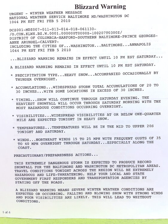
I think that was storm #1. A lot of people forget that every county in the state of md (except Worcester) was under a blizzard warning for the second storm… I don’t know if that will ever happen again
-
On 1/31/2024 at 11:00 PM, George BM said:
The surface low will most likely bottom out in the upper 960smb range around 03z-06z Sunday as it stalls or possibly does a small loop around Ocean City, Maryland
Pulitzer Prize worthy
-
17 minutes ago, Ji said:
i think the Feb 13-14 storm has disappeared
It is alive and well on the euro (albeit too warm)
-
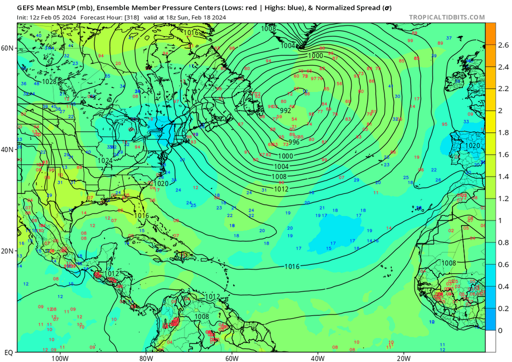
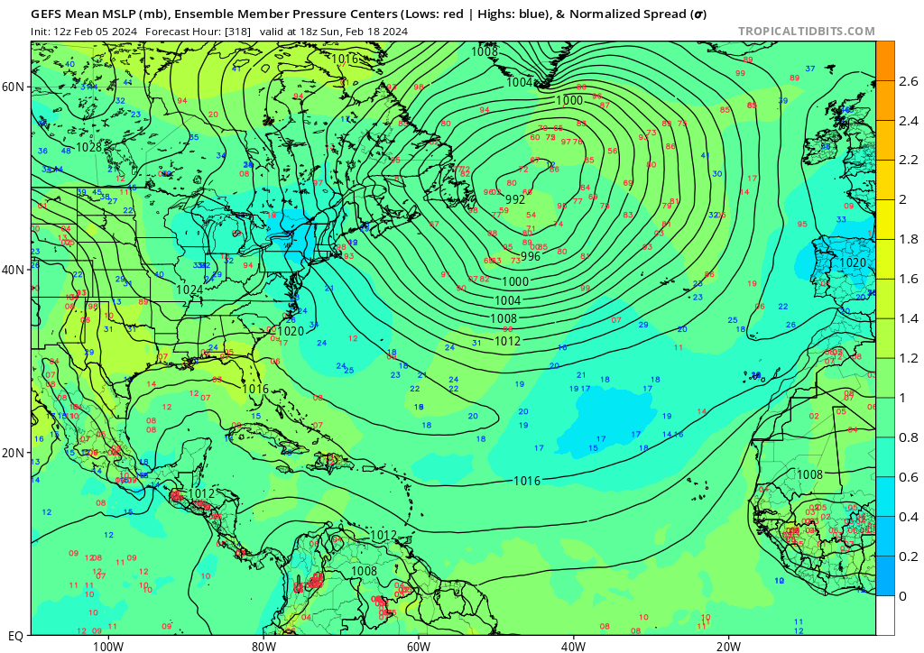
It is pretty interesting to look at the progression of the Individual members on the GEFS.. look at the confidence on the 50-50 at 318 hours..
-
3
-
2
-
-
52 minutes ago, stormy said:
Kudos to you
In am not criticizing. It was worth a posting and I am excited about the potential. I am just pointing out that we are in our climatological high point of our snowstorm chances and the only thing we get on the operational models is a 480 hour mega hecs
-
1 hour ago, Stormchaserchuck1 said:
Wish I had the 16day GFS ensemble maps from 10 days ago.. I think in the longer range that everyone is talking about (last week of Feb/early Mar), we might have to worry about the staying power of +pna: It hasn't sustained more than a short time for a very long time.
My nephew just called me and said.. you gotta see the extended euro. I said it’s a fake storm.. then he said.. “if stormchaserchuck is excited then I am excited”
-
10
-
-
I can’t believe we are looking at 480 hr snow maps. This has to be a new low.
-
2
-
 1
1
-
4
-
2
-
-
5 minutes ago, Terpeast said:
and that's geopotential height, not thicknesses!
Can you explain the difference with this?
-
1
-
2
-
-
12 hours ago, Weather Will said:
WB 18Z GEFS way to go but 2 big hits for the 15th.
I would venture to say that any run of the GEFS from December to February on a 15 day lead time would show at least one good snow storm for our region
Unless the majority of the members are saying the same thing, 15 days is too far out to take seriously.-
1
-
1
-
-
47 minutes ago, Bob Chill said:
Complicated... lol. If the low stays completely separate from the northern stream like most guidance shows, a flush hit carries a huge risk of flush rain. Thermals are awful without stream interaction. Can that still happen? Sure, it's in the envelope. But getting stream interaction downstream is backwards. We need to tap downstream and pull cold nearly backwards. Idk man. That's a tall order lol
I see.. so probably have to wait. this time of year is rough.. when you are getting closer and closer to the end of our window and nothing is on the horizon... its hard to watch.
-
1 hour ago, Bob Chill said:
That's been happening since I started tracking. Reasons are simple. Storms want to gain latitude. It's their job. Strength of storm is never resolved so as storms look "better" or stronger as lead times shorten, there's like an 88% chance it fights to push north. Without a transient big block or more classic blocked flow, storms will always butt against walls and usually bully them a little.
Happens both ways though. A good storm in the mid range that weakens will almost always end up south (or get squashed into dark matter lol). Blocked flow can easily push a storm south in the mid to short range. And that's certainly happened. Congrats short pump was born in that setup lolol
Eta: one more thing. Op models appear to have a bias with depth of cold in the mid range. Fronts rarely push as far south as initially modeled and cold moderates more than expected. This is often a result of cold taking longer than expected to bleed east.
Right.. I agree with all of this. So at what point does that Closed Upper level low track just far north enough to paste us with heavy snow?
-
8 hours ago, Ji said:
Canadian comes close
Sent from my SM-A515U using Tapatalk
Do you know why it is that every time we need a storm system to not trend north in the 120-180 time frame, it inevitably does. But if we do need it to trend north, it inevitably doesn't?
-
1
-
-
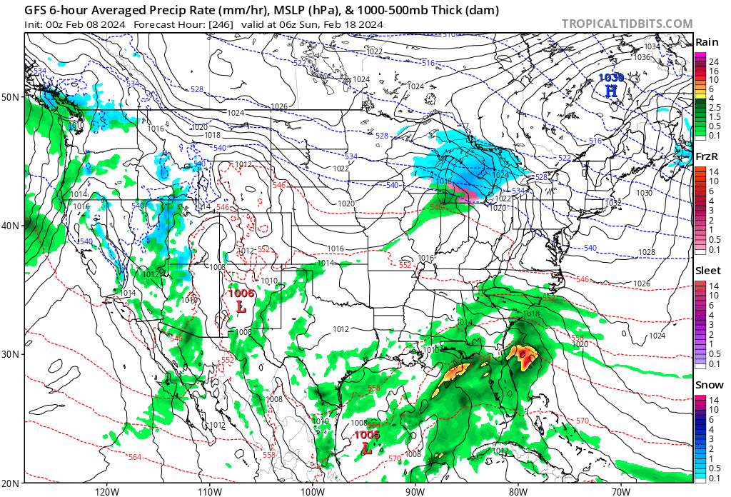
25 minutes ago, frd said:
DT update
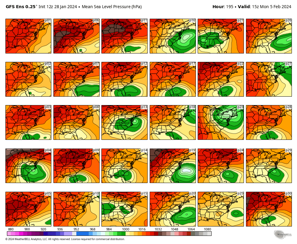
·9,047ViewsWORKING HYPOTHESIS so if we accept the idea that the northern Jet Stream is overdone then the southern LOW is not along the Gulf Coast on FEB 4-5 . It will be back in the Tennessee Valley and the big snowstorm threat is still alive. IMAGE 2 shows the individual 30 members of the 12z GFS Ensemble . Of the 30 members ….13 of them show a significant surface LOW that would bring significant snowfall to the Middle Atlantic region. some of these Solutions also include the northern Mid-Atlantic and New England. Some do not. Given the GFS propensity to overdo the northern branch and suppress southern systems 13 out of 30 is almost 50% which is not bad.


Why didnt you show the 18z? It was out when you posted this.
-
1
-
-
Congrats everyone!
-
I hope you all enjoy! I am in Waikiki right now and I have to admit I am a little jealous. I knew it was gonna snow the minute I left md.
-
9
-
1
-
-
4 hours ago, stormtracker said:
Like Deck Pic suggested, lets get a new thread with some fresh juju. If it fails juju gonna be so sad. Whatever, I laughed.
Smith-schuster?
-
1
-
1
-
2024 Valentines Day Rain/Snow/Who The Hell Knows Thread
in Mid Atlantic
Posted
Not a member above the mason dixon. It is less than 5 days and it hasn’t shown a run without any snow in the ma in like 10 runs. I have never in my life seen the euro trend toward the gfs when we need it to. Maybe just maybe this will be the miracle and the euro caves here in about 30 minutes