

MDScienceTeacher
-
Posts
285 -
Joined
-
Last visited
Content Type
Profiles
Blogs
Forums
American Weather
Media Demo
Store
Gallery
Posts posted by MDScienceTeacher
-
-
Just now, Bob Chill said:
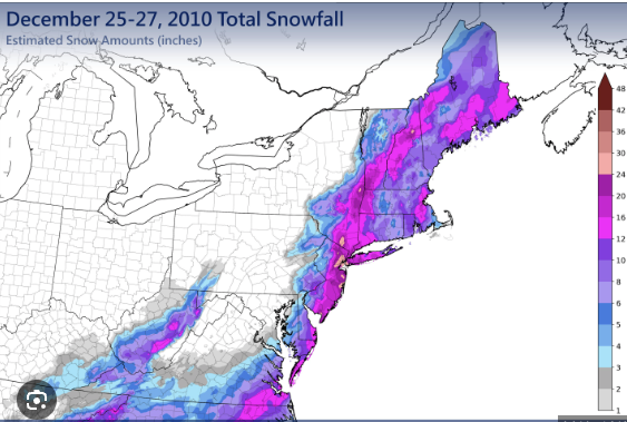
Boxing day hit at the perfect time for maximum hope and dream destruction. Recency bias of the 2009-10 had us all overconfident lol. I was nearly certain it would work even when the wheels got loose in the short range. Nope, boxing day performed exactly like many of its predecessors. It's a big club and we ain't in it lol
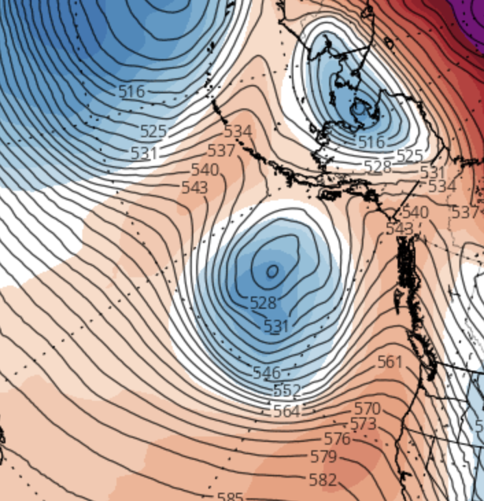
Thats the point I am trying to make.. there is a precedent for this fail mode.. my apologies for the graphic. I can take it down.
-
Just now, snowfan said:
This post = immediate ban. I don’t make the rules
It is important that people understand how things work here wrt to snow.
-
 2
2
-
-
31 minutes ago, mitchnick said:
I hate to say it, but as depicted, it sorta reminds me of Boxing Day, but without a total skunk to the central portion of the forum including Metros and suburbs. You'll see what I mean when you see it on TT or Pivotal.
Right.. and I dont know if many people remember but boxing day had a WSW for 6-12 inches along the Baltimore Washington Corridor. The models were showing warning level snow up until start time. We were on the fringe then and we are on the fringe now. the biggest issue with boxing day was Dry air. We had 8 hours of virgo followed by 8 hours of snow tv. Also, boxing day hit the tidewater epically hard, went our to sea and then turned the corner, retrograded and hit NYC metro. It literally went around us.
-
 1
1
-
3
-
 1
1
-
 1
1
-
-
5 minutes ago, Ji said:
I think the track is pretty much set. We just have to hope for a stronger storm.How does this happen. Five days ago, I said its a rug pull and I wouldnt let my self get pulled in again.. I am hopeless.
And I dont want to hear the crap about setting expectations or how 6 inches of snow is great or how we werent going to get a HECs to begin with.. I dont want to hear it. Because I have news for you.. the fringe is looking boxing day-ish. there I said it. And I dont think I can take another day of snow tv while sitting on an winter storm warning for 6-12 inches... waiting for it to accumulate as someone to our south is getting 20 inches of snow. The impossible happened. for the first time in model history (ever) the GFS was right and every other model was wrong.
-
2
-
3
-
-
1 minute ago, MN Transplant said:
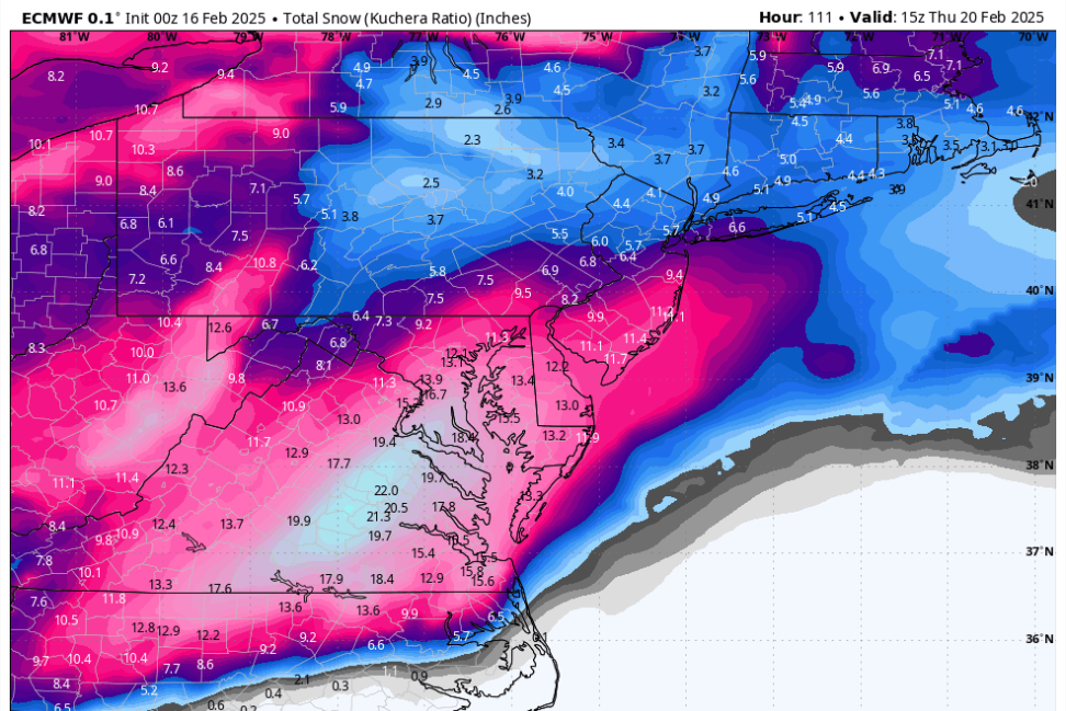
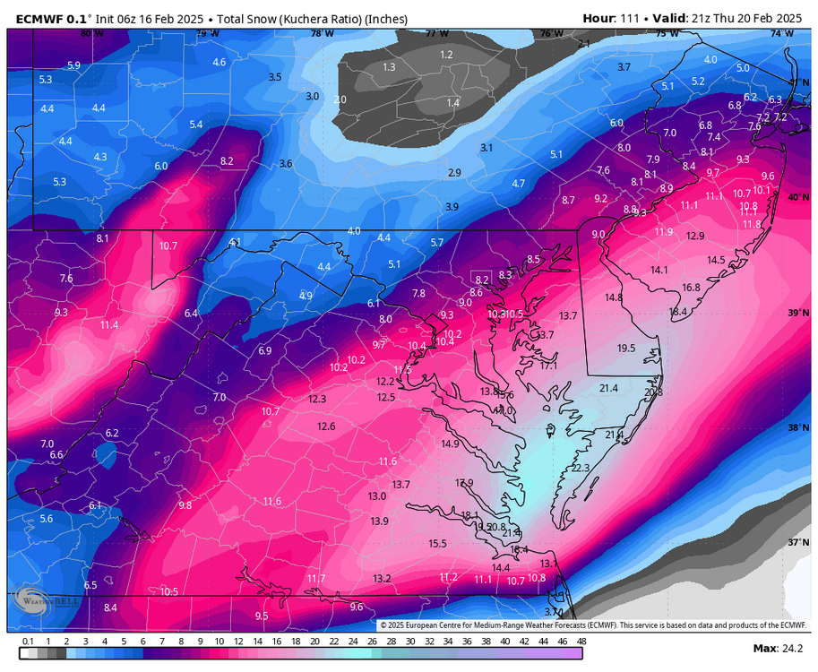
Ok, summary for those waking up. Still a jackpot to the south and east. Huge difference in how big/strong the storm gets, which affects the totals to the north and west. 10:1 snow amounts for DC:
- GFS: 5" (06z), 4" (00z)
- Euro: 6.5" (06z), 9" (00z)
- Canadian: 0.5" (00z)
- ICON: 10" (06z), 5" (00z)
- Ukie: 2" (00z)
Other than the ICON, if this verifies than it is a total and complete fail. Two days ago, we had every single model in our camp except for the GFS. and several people said said that there is no way in hell every model would cave to the GFS.. and here we fucking are. I cant believe what I am seeing.. how could this happen again?
-
2
-
2
-
1
-
 1
1
-
Does anyone know how to create the animated png? That is what I really wanted to post.. I didnt have the patience to figure it out.
-
1
-
-
-
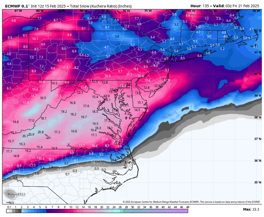
Last three Euros (not including 6 z)
-
2 minutes ago, Maestrobjwa said:
I have two bars. That one for an all out win. 6"-7" for a bare minimum
6-7 is a fail given what the models have been showing… let’s just leave it at 10
-
2
-
1
-
-
2 minutes ago, Ji said:
They should be more amplified they run at a higher resolutionReally ?? I thought the ensembles have the same number of grid points as the op? And each member just gets initialized with slightly screwed data to find out how reliable the run is?
-
Just now, mitchnick said:
It exits stage right at the VA Capes, which cuts off our totals.
I know we have said this many times in the past but we could easily see a slight Trend northward as we move closer to the event. Especially with a more amped storm. I am loving where we sit right now.
-
1
-
-
23 minutes ago, frd said:
I gladly take this and call it a winter.
I might be dead the next time a foot of snow falls here.
.
Come on man. It can easily snow a foot here. This winter has proven that winters are far from over for our region!
-
1
-
-
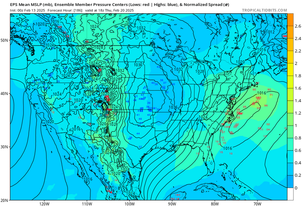
1 hour ago, WxUSAF said:
We'll pass the 100 hour mark with the 0z runs tonight. Storm starts forming in 60-ish hours. We're getting pretty close. There's going to be a storm nearby. Miss risk seems mostly associated with something that hits Norfolk area then slides OTS.
Have we made it past the dreaded Pacific Dropsonde data injection point yet? I dont know if you guys remember but the last storm was a 10-15 inch deal before @stormtracker jinxed it with the storm thread and Dropsonde data. At any rate, she looks healthy to me:
-
2
-
 1
1
-
-
9 minutes ago, Ralph Wiggum said:
I don't give a fuck who jackpots. Congrats. Just let me get in on a couple inches up this way. Not asking much, I'm not picky. Just about my beer.
The fact that one is showing up is telling imho. That’s a signature of every big storm in the mid range. You start seeing this high total bullseyes right at the pivot point for the storm. I am just glad we are seeing one.
btw did you see the surface temps are at around 20 for these ccb panels.
-
1
-
1
-
-
5 minutes ago, winter_warlock said:
Toii me the GFS looked a little disjointed compared to EURO,UKMET AND GEM
Yeah it looks like all systems go but I just want to give @Jisomething to think about.
-
1 hour ago, stormtracker said:
I hope you're joking, because you know what comes next, right?
I have been lurking since Boxing Day.. and I know that there is something to it.. like whenever it finally snows is inevitably when someone is leaving town. Anyway I don’t leave til night time. As long as I get to watch it fall I am good! And if I get a delay because of a foot or more of snow so be it!! It’s a win win for me.
-
1
-
-
3 minutes ago, psuhoffman said:
A Euro UK Ggem trifecta is a hill I’m willing to die on. If we have to be missing one of the 4 major global the GFS is the one I’m least upset about. I can’t remember the last time it was off on its own like this and won.
@Ji the one time ever in history that the gfs pulls off a coup would be now right?
-
 2
2
-
-
2 hours ago, stormtracker said:
Anybody have important plans Thursday?
Yeah I have a flight leaving for Puerto Rico… been planned for months now
-
27 minutes ago, stormtracker said:
.. Also, I hate we had these runs today, because some of you will become absolutely unhinged and unmanageable when things start see-sawing with the models.
Can't wait!
-
4 minutes ago, Snowman. said:
Jan 2016 the models were all generally locked in to a major snowstorm close to a week out. Right now every major model besides the dogshit GFS has the general area with us near or at least a foot so i’m pretty optimistic.
Our last two storms had a period in the mid - long range that featured all of the major models showing MECS like totals in the Baltimore-Washington Corridor only to correct south once we got below 96 hours. Until I see different, I am going to be stay cautiously optimistic but be open to the fact that the Euro could do the old rug pull at any time..
-
1
-
-
2 minutes ago, frd said:
Must be the Nina backdrop and lack of phasing storms and of course lack of a STJ. So much for climate change
day after tomorrow storms.Fixed it for you .. lol JK.. It definitely is a good sign though that we were able to get Wall to Wall cold this winter
-
Yup! My favorite ensemble plot is the individual members.. this type of agreement 180 hours out is a pretty big deal
-
2
-
-
15 minutes ago, Warm Nose said:
Temps are fine, just not enough QPF - the cutoff is real and it's sharp.
Silver lining - not gonna bother to shovel with the rain and torch that's on the way.
So I am way up in northern hoco md and it has been steady light snow all day and we managed to break 3.. there wasn’t so much of a cutoff around here it was more gradual. Where are you located?
-
6 minutes ago, Warm Nose said:
2.5" and struggling to get to 3" - doesn't look great for chances.
Hmmm.. I am in Elliott city and I am 3.5 already. I am really surprised you have gotten to 3 yet. Is it temp issues? Looks like plenty of returns down there

February Medium/Long Range Thread
in Mid Atlantic
Posted
I am sorry.. i see that there are some rules around this now.. I should have known. I am gonna get away from the computer for a while and get some exercise. Let’s see what happens later today