


Stormchaserchuck1
-
Posts
5,610 -
Joined
-
Last visited
Content Type
Profiles
Blogs
Forums
American Weather
Media Demo
Store
Gallery
Everything posted by Stormchaserchuck1
-
It's still a macro-pattern, that means more activity with fewer systems. Seem pretty fitting going into an El Nino winter. Watch the central-ENSO subsurface, this has been cooling, and if that region continues not to warm the El Nino will have less effect in the Winter, despite what happens at the surface.
-

2023 Mid-Atlantic Severe Wx Thread (General Discussion)
Stormchaserchuck1 replied to Kmlwx's topic in Mid Atlantic
Yeah, the air is too saturated. Im watching cumulus building to the north but it's nothing like the last few days (Harford Co) edit: nevermind, the storm is really going. Probably close to 1" of rain. -
low to mid 90s today across the area with -NAO. The pattern is N-S is elongating a trough or ridge, through Hadley Cells (15N-80N). I think in the Winter a -NAO will be hard to lock cold, but a stronger El Nino could overpower. This -NAO = warmth thing is really unbelievable because it is happening so often.
-
2023 Mid-Atlantic Severe Wx Thread (General Discussion)
Stormchaserchuck1 replied to Kmlwx's topic in Mid Atlantic
90F here, Sunny. You can tell the air is saturated though. -
El Nino 2023-2024
Stormchaserchuck1 replied to George001's topic in Weather Forecasting and Discussion
^That's a good post. I'm worried about the cold pool developing in the central-subsurface too. The mid-July -PNA may be with an enhancement of this. It's been a tough area to stay constantly warm since the Winter, with a few short term cooler pushes having happened since March, overall a weaker +. -
El Nino 2023-2024
Stormchaserchuck1 replied to George001's topic in Weather Forecasting and Discussion
Nice -PNA, 594dm block ~7/14. These correlate with a cooler central-subsurface. After a series of +pna's, I wonder if this is evening out, giving less credence to El Nino effecting the N. Hemisphere pattern. It may seem like I'm doing heavy play-by-play, but there are some strong constants right now in the global pattern that I would like to see break. -
2023 Mid-Atlantic Severe Wx Thread (General Discussion)
Stormchaserchuck1 replied to Kmlwx's topic in Mid Atlantic
Some rain with 2nd cluster of clouds. Areas that didn't see so much so far might do better tomorrow. I like this front moving across the Midwest ~7/8. -
2023 Mid-Atlantic Severe Wx Thread (General Discussion)
Stormchaserchuck1 replied to Kmlwx's topic in Mid Atlantic
Some booms to my SSE (Harford county), nice building cumulus, partly sunny. It just rained 3 hours ago. We are drought busting like crazy. For now on, take months of below average rainfall as instability in the Spring/Summer. Although, if it wasn't El Nino, I don't know that we would be getting this. -
2023 Mid-Atlantic Severe Wx Thread (General Discussion)
Stormchaserchuck1 replied to Kmlwx's topic in Mid Atlantic
7-7/8 looks interesting with a trough cutting into/through the midwest. -
El Nino 2023-2024
Stormchaserchuck1 replied to George001's topic in Weather Forecasting and Discussion
3 years prior to 57-58, we had the most negative monthly PDO on record until last year. It was a transition time/event break point. -
El Nino 2023-2024
Stormchaserchuck1 replied to George001's topic in Weather Forecasting and Discussion
Global SSTs, chicken and egg. I do know that when a warm/cold front move by, the SSTs warm/cool thereafter. ENSO Is SST, but I wouldn't put much weight on other areas unless it's extreme, or a deviation from upper level pattern. -
El Nino 2023-2024
Stormchaserchuck1 replied to George001's topic in Weather Forecasting and Discussion
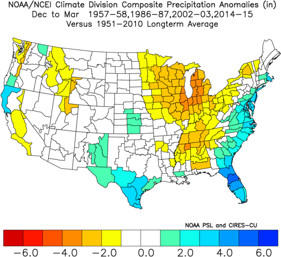
3 year -ENSO followed by 2-year +ENSO, 4th year being an El Nino, also includes 02-03 and 14-15. (4) years since 1950 forward and backward: 57-58, 86-87, 02-03, and 14-15, not a bad list of years if I'm right about our continuation probability next year. edit: 76-77 qualifies and minus 54-55. That's a lot of weak events though. You might want to phase out the Weak Nino's. 86-87 and 14-15 are El Nino, -QBO matches out of the list.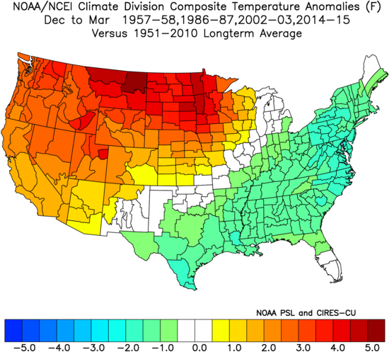
-
El Nino 2023-2024
Stormchaserchuck1 replied to George001's topic in Weather Forecasting and Discussion
I've found 1957-8 and 1986-7 could be good Winter analogs, Both were the start of 2 year El Nino's, which I see as a possibility if this one doesn't go too strong (it's about potential energy). They also both came off 3-year La Nina/-Neutral. -
Another beautiful night, still, peaceful. orange moon. Love it after it rains
-
If the precip drought continues, we could be looking at the potential for some boomers going into the Winter (as that would signal it's a macro pattern).
-
El Nino 2023-2024
Stormchaserchuck1 replied to George001's topic in Weather Forecasting and Discussion
The +AMO may be something that starts with 15 La Nina's/8 El Nino's, and have more El Nino's vs La Nina's at the end (if it's extended), I fail to see the strong correlation there. -
El Nino 2023-2024
Stormchaserchuck1 replied to George001's topic in Weather Forecasting and Discussion
The N. Pacific has responded moderately, by giving us less -pna's, and a few +pna's recently, but D15 models show an Aleutian ridge, which could correlate with some subsurface cooling. If this continues through late July, I can't see us getting past a Moderate peak. https://ibb.co/7kGNKpG https://ibb.co/0j72JfM -
El Nino 2023-2024
Stormchaserchuck1 replied to George001's topic in Weather Forecasting and Discussion
This isn't too impressive, The Western region in recent La Nina's match what we are seeing in Nino 3.4, heading into July We have had these Kelvin waves in recent Springs, anyway Having warm subsurface starting the previous Oct-Nov has been my par for "what could have been a strong event".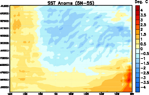
-
It's beautiful outside.
-
2023 Mid-Atlantic Severe Wx Thread (General Discussion)
Stormchaserchuck1 replied to Kmlwx's topic in Mid Atlantic
Round 3 incoming. It had cooled off to the 60s around 6pm, now humid again with distant thunder. -
El Nino 2023-2024
Stormchaserchuck1 replied to George001's topic in Weather Forecasting and Discussion
This is a good example of the relative minimum's we are still experiencing at a time of global warming. This event remains uneven with the string of La Nina's, and global warming as a whole (if everything were to catch up). -
2023 Mid-Atlantic Severe Wx Thread (General Discussion)
Stormchaserchuck1 replied to Kmlwx's topic in Mid Atlantic
Massive lightning bolt shots just to my east. Edit: sirens then the storm cooled down.- 2,785 replies
-
- 1
-

-
- severe
- thunderstorms
- (and 3 more)
-
2023 Mid-Atlantic Severe Wx Thread (General Discussion)
Stormchaserchuck1 replied to Kmlwx's topic in Mid Atlantic
Cell to my south is really lighting up. Many flashes (1/1-2 seconds)- 2,785 replies
-
- 2
-
-
- severe
- thunderstorms
- (and 3 more)
-
2023 Mid-Atlantic Severe Wx Thread (General Discussion)
Stormchaserchuck1 replied to Kmlwx's topic in Mid Atlantic
I have nice, smooth Mammatus clouds overhead in Bel Air, cell building to my south. Edit: some CC lightning next to a blue sky. Wish it were dark.- 2,785 replies
-
- 1
-
-
- severe
- thunderstorms
- (and 3 more)
-
The last 2 El Nino's / -QBO's were 14-15 and 09-10, that's the 2 on record in the last 25 years. Last Winter was La Nina/ +QBO (opposite). Extend it to 1979 and you have 86-87 and 91-92. I've contested that a surface +NAO could work better for us these days than -NAO's, but that's another story.