

78Blizzard
-
Posts
3,693 -
Joined
-
Last visited
Content Type
Profiles
Blogs
Forums
American Weather
Media Demo
Store
Gallery
Posts posted by 78Blizzard
-
-
Ukie was improved for coastal and SEMA areas from 12z.
-
25 minutes ago, 40/70 Benchmark said:
Its worked our more often than not for that area over the past several years.
No, I think you have to go back a bit further than that. The last couple of years have been crap here.
-
32 minutes ago, weathafella said:
Yeah but to me 6+ is a win after nearly 2 years of garbage.
Yes, it is a win, but just saying...
-
 1
1
-
-
I just hate to be in or near the bullseye in many of these models with 2.5 days to go. It usually doesn't work out.
-
1
-
-
-
6 minutes ago, powderfreak said:
It’s a pretty uniform SFC temp display across the south/east half of SNE… from CT to the South Shore.
That steady moderate to heavy precipitation wet-bulbs everyone to 32-33F. Theres some paste in there.

The earlier GFS runs had 925 temps collapsing after 9z, despite what the NAM was showing then.
-
-
2 hours ago, JoeSnowBOS said:
All Boston meteos saying mostly rain inside 95 with second half snow ranging from a Dusting to maybe 4 inches. Time will tell
.1 hour ago, rgwp96 said: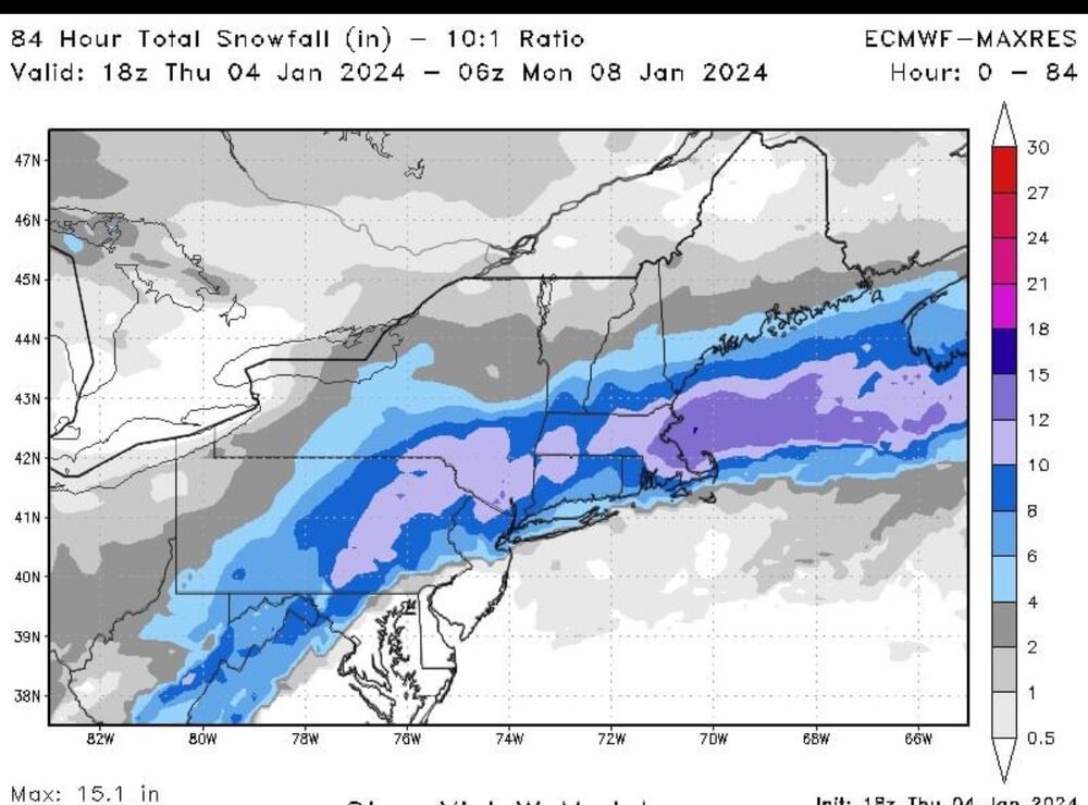
TV mets say rain and up to 4" inside 95, yet Euro (and GFS) says those areas get the heaviest snow, clown map or not. Other clowns say the same. The same clown maps have no problem showing rain for the CMC, NAM and even the Ukie.
-
8 minutes ago, JoeSnowBOS said:
All Boston meteos saying mostly rain inside 95 with second half snow ranging from a Dusting to maybe 4 inches. Time will tell
.I think they are letting those 45° SSTs get to them. Using the Euro and GFS, I don't see anything supporting rain beyond 3-4 miles of the coast.
-
1
-
-
925 temps crash lower after 09z when the good stuff gets going. -2C° at 9z here and heading lower from there.
-
The RGEM track was almost a carbon copy of 12z's run. Seems to have locked in on that, at least until we get to 0z, lol.
-
Looks like it may be a bit colder this run.
-
15 minutes ago, George001 said:
I’m thinking 10-15 here, it’s coming.
That's about what I was thinking, too. I have seen various model runs over the past couple of days enhancing the snow in this general area. We'll see.
-
6 minutes ago, Winter Wizard said:
Mixing issues near the coast otherwise Euro looked sweet for most people. Getting closer to locking in a nice hit.
925's get no higher than -3°C here, so taint should be very minimal, if at all.
-
Gfs bombing out late gives the outer cape the good stuff.
-
4 minutes ago, Sey-Mour Snow said:
Here's the precip totals through 12z the 1st batch of WCB , everyone in this forum is cold enough to snow, with more after this as mid levels fill in

That's a 50% cutback in qpf from the 12z run at that time frame.

-
 1
1
-
-
4 minutes ago, OceanStWx said:
https://www.nhc.noaa.gov/text/MIAREPRPD.shtml
Well there we go.
Looks like some of those Pac flights are recon for the 9-10th storm.
-
1
-
-
7 minutes ago, CoastalWx said:
I was just thinking.....when have they ever had this so far in advance?
Probably quick on the draw since they had few opportunities last year, lol.
-
1
-
 1
1
-
-
13 minutes ago, wxsniss said:
Growing confidence from EPS/Euro we see double digits somewhere in SNE, finally get this monkey off our back...
Pike vs. NE MA vs. NH-MA border vs. SE MA jack tbd, but outside 128 belt Foxboro to Fitchburg looks great atm
Opening bid from NWS... seems they are heavily factoring marine influence... the low-res Euro soundings are plenty cold 925 on up, so probably see that gradient closer to coast:

Is this depiction telling us that the models do not weigh marine influence very accurately?
-
4 minutes ago, weathafella said:
Like days of old....1960-61 vibe for that. Of course Euro severely cuts the 10th way way west which you would think wouldn't happen with the 7th wound up but GFS more or less ignored the 7th and is signaling a colder solution for the 10th.
Yeah, that 10th storm could cause some real flooding problems with that snowpack.
-
2nd half of storm is quite cold, too with 2m temps dropping into lower 20's.
-
Actually a bit further north than the Ukie.
-
Wow, similar track to Ukie and with the qpf, too.
-
I wouldn't want to pin my hopes on the Ukie. Although it was pretty consistent from 12z to 0z. Just strange that the further south track led to more qpf in much of SNE. It is definitely the wettest of the models.


Monitoring first regional significant winter impact event. Magnitude likely tempered. At this time NE PA/SE NY and SNE primarily. Jan 7/8.
in New England
Posted
Start taken' 'em up...