

78Blizzard
-
Posts
3,693 -
Joined
-
Last visited
Content Type
Profiles
Blogs
Forums
American Weather
Media Demo
Store
Gallery
Posts posted by 78Blizzard
-
-
16 minutes ago, ORH_wxman said:
Hrrr is def less IVT. Consolidating quicker. Nice to see that trend from 18z reverse at least on one model.
It's all over here at 18z according to that, while others have it just getting going then. Track looks similar to RGEM.
-
55 minutes ago, CoastalWx said:
EPS would argue op is on the eastern edge it seems.
GEFS did the same thing.
-
Just now, tim123 said:
18z euro rolling yet?
Later now due to DST.
-
1 minute ago, NorEastermass128 said:
Maybe. Hopefully it doesn’t end the same way, with hurt feelings, name calling, and bans galore!

Any further eastward movement by the next GFS could bring us that.
-
 1
1
-
-
4 minutes ago, Sey-Mour Snow said:
Ya usually we don’t let them get this long. I think tip should start a new one for some good juju?
That would only be fair since he warned of this threat 9 days ago.
-
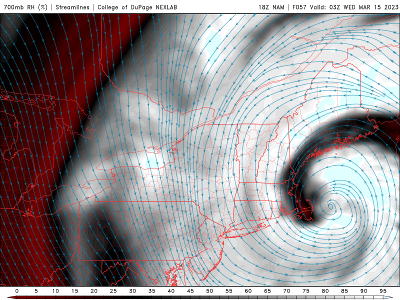
Here's another solution from the 21z RAP. Takes it into RI, then W through CT and out to LI at 0z Wed, lol.
-
24 minutes ago, mannynyc said:
The op GFS and GEFS are just a little different...


If the GFS is one of those members, it has to be the one furthest OTS.
-
48 minutes ago, Typhoon Tip said:
The overwhelmingly powerful moving synoptic parts will obliterate the BL warming ... much more likely in a uniform result. Too much tech dive is obfuscating common sense - not just in here but in the general Met community.
These subsuming N/stream fusion into diabatic inject S/streamers, become dynamic hammers ( in the maudlin turn of phrase). None of the interpolated snow products ...and ( I feel ) quite a bit of human interpretation, are not getting the big picture here of what this kind of event is capable of becoming. Hopefully the nit picking keeps it upper pedestrian/lower major like that... Heh.
Just like no one guessed a tropospheric fold would strafe SE zones with sustained 'cane winds in 2005, or how 128/95 becomes a stranded parking lot on the eve of 1978 Feb 6 ... the upper bounders like to impose "wild card" severity. This one fits that ilk.
I'm particularly concerned along a Willimantic CT to Bebford MA where for a time, thick caking/rhyme snow may then freeze while being struck with high winds into that snow loaded infrastructure.
Otherwise, I'm not too concerned about the risk for heavy snow as singular metric. I've seen this town cut through 22" snow storm twice and I was able to hit the gym later the same afternoon ... Snow, alone, is not the same beast to civility it was 40 years ago. But, if the visibility is very low and the wind manages to gust in the interior and the temperature is 30 F ... this turns into a different animal.
I don't buy the 18z NAM and other waffling as negation. It's roughly half way between the 12z and the oddly barren 00z run ...and is more a reflection of wobbling with the internal physics ( giga noise). It's too possible that a dangerous scenario unfolds to worry about that, as the players are not in question - unlike other events this year. They are pretty well accounted for.
The GFS is largely dismissed
Kudos to you for zeroing in on this impressive signal 9 days ago.
-
Just now, 78Blizzard said:
LOL, RGEM hooks and stalls in BOS bay.
-
1
-
-
Just now, 78Blizzard said:
Actually, the 925s are much better by 15z than the last run on the RGEM.
-
Actually, the 925s are much better by 15z than the last run.
-
Early hr 24 look at RGEM shows it probably wants to continue being stubborn.
-
1 minute ago, Sey-Mour Snow said:
Looks like an hour burst of snow then several hours of light white rain on nam down here..

That is slightly better than 10-1 here considering that there was rain at the beginning. Not surprised with the colder look aloft, as well as at the surface.
-
8 minutes ago, dendrite said:
May have to watch the dryslot in E MA at some point…cloud tops still near -10C though.
At hr 57 most of the precip is over.
-
Stalls over elbow of cape between 18z and 0z.
-
Colder NAM run at surface and aloft. 31°F at 18z here verbatim.
-
The 925s collapse S at 12z Tues.
-
 1
1
-
-
13 minutes ago, DJln491 said:
Box latest
Now we're getting more reasonable. WSW should be extended in some areas.
-
15 minutes ago, WxWatcher007 said:
Early HREF. Through 12z Tuesday.
Of interest to me: NW CT is getting smoked here, and except at the immediate shoreline we are seeing 2-4 in southern CT and some 4-6 in northern Fairfield and New Haven counties verbatim.
.thumb.png.a3ff0a54679572203651d6fa7143d53b.png)
That the map is showing even minor amounts of snow at 12z Tuesday in EMA is encouraging.
-
FWIW, which is probably not much, the mesos ARW, NSSL, and FV3 each respectively bring the low over the BM, just off the coast of NJ, and into NYC/CT, although if anyone can figure out where the nipple low is on the FV3, good luck.
-
1
-
-
1 minute ago, 40/70 Benchmark said:
Not for my area...just a more moderate impact.
I meant as far as a foot or more. Moderate impact here, too.
-
1
-
-
If the NAM and GFS go to that nipple into CT it's game over for EMA and many other areas.
-
UK was 5°F colder at the surface here at 18z Tuesday than its previous run, yet the Euro was 6°F warmer than 0z run. It was all about that nipple. The Euro had it and UK didn't. Same with the 925 thermals at 18z.
-
UK is 5 degrees colder here at 18z Tuesday vs the 0z run and the 925 temps are also colder. But then the low at 0z is west of last night's run, so the thermals then go higher. It will all come down to the position of that low between 18z and 0z. The UK and Canadian are the furthest west, pending the Euro.

.png.ed7a56648ef1d6f3b5c31bcb89d97b9b.png)
The last hurrah? Putting all the eggs in the Tuesday 3/14 basket
in New England
Posted
I was just kidding with Tip last night. Little did I realize this could actually happen. Let's hope the 18z Euro was a burp run.