

Lightning
-
Posts
1,182 -
Joined
Content Type
Profiles
Blogs
Forums
American Weather
Media Demo
Store
Gallery
Everything posted by Lightning
-
I believe it had more do to with us knowing the biases. We knew the NW trend would continue until the bitter end. We knew the QPF could be cut to 60%. We knew if the EURO and GFS were different than ignore the GFS. I mentioned in an earlier post that several model update have left us with a lot less trust in any one solution. There is a lot more weak and further south with some occasional stronger further north. The biases have become difficult to predict (though generally I think we are seeing more weaker and further south overall than we were ever used to).
-
Makes not sense for watch IMO. They must be banking on a solid NW shift from all the major model guidance and buying the NAM 12k.
-
Ha. Sheboygan WI for me for MCS. Milwaukee seems to always head down to AA then into DTW.
-
Yes that was very true especially in the 2000-2015ish era. I would like to note that some time after 2015 there were some significant model updates that seemed to kill off the significant NW trend we used to see. Now it seems there are some NW trends and some SE trends and some that pretty much stay the same. Not saying this one is set in stone at all rather the overwhelming NW trend we used to experience is not what it used to be.
-
It's funny I have the landmark places all picked out where I need to low to go with the various types of storms. Toledo wouldn't be bad for me either; it just puts me on the southern edge of the defo band (great reward comes with great risk ).
-
Cedar Point is the best case scenario for me that is for sure for this type of storm.
-

Winter 2024-25 Medium/Long Range Discussion
Lightning replied to michsnowfreak's topic in Lakes/Ohio Valley
ICON, ICON, ICON!!! -
I haven't looked at the SREF in a couple years now. They were more comical than useful for snow IMO.
-
Agreed; I would prefer not to get ice storm either!!! The Vort at 500mb is not closing off and remain progressive. The shifting in the models seems to more related to the Vort placement. I don't think there is much further NW it can go. Of course it is the weather
-
Got to love it. Today the GFS goes weaker/South and Euro goes north/stronger. . I'll take the RGEM . Wouldn't be fun without the model chaos.
-
Winter 2024-25 Medium/Long Range Discussion
Lightning replied to michsnowfreak's topic in Lakes/Ohio Valley
Being the Euro at least I have a chance it could happen. If it was the GFS it would be a flat 0% chance
-
Light stuff has begun here a bit ago . The models last night were basically giving me nothing. Hopefully 1" or so will fall!!
-
Winter 2024-25 Medium/Long Range Discussion
Lightning replied to michsnowfreak's topic in Lakes/Ohio Valley
Sadly the model just are not that good especially at the surface in the mid/extended for this area. The past few years I personally have treat anything they show at the surface beyond 60 hours is just pure . Like playing the lotto; you know your not going to win but just the daytime dreaming of winning it is why many play it! The main thing I get is that this is going to be more active than we seen all winter and there is definitely potential for some decent events!! Much better odds -
Winter 2024-25 Medium/Long Range Discussion
Lightning replied to michsnowfreak's topic in Lakes/Ohio Valley
Fixed -
Winter 2024-25 Medium/Long Range Discussion
Lightning replied to michsnowfreak's topic in Lakes/Ohio Valley
GFS today has joined the party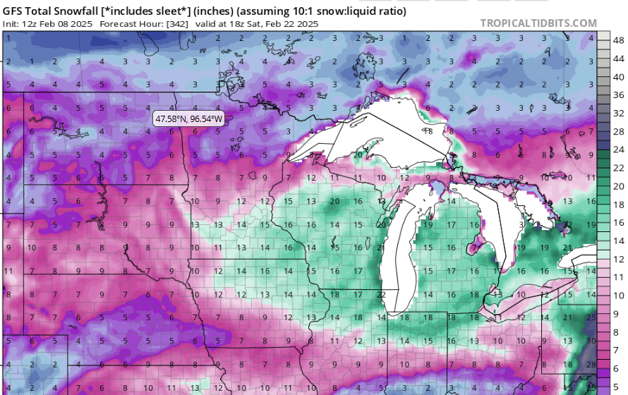
-
A storm the models haven't disintegrated into nothingness within a couple model runs!!
-
Winter 2024-25 Medium/Long Range Discussion
Lightning replied to michsnowfreak's topic in Lakes/Ohio Valley
This is just some thought and not directed toward you. Just something I think might be impacting this conversation. Part of the issue: "2013-14 and 2014-15 were the last good winters." This might be very true for some areas (I don't know as I don't live everywhere ). But where I live this is not true. Yes 2023-24 was HORRIBLE. 2017-18 was Flint's snowiest winter. There have been several awesome events in the past 10 years around this area. My point being that everyone perspective is different based on your location and the events your location is getting. I recall a few years ago I was getting 2.5" of rain in a thunderous crashing thunderstorm. Just 10 miles away it was sunny and not a drop. Depending on your location can make all the difference in the world to your perspective of the weather!! In the end right now for me this winter is not wonderful but it also has not been that bad. But I will absolutely agree it has been horrible in your area and I know it has been for a few years now. -
Winter 2024-25 Medium/Long Range Discussion
Lightning replied to michsnowfreak's topic in Lakes/Ohio Valley
As do most of those who do these social media posts. Considering that is basically the main thing most weather geeks want (i.e. historic events), they are just appealing to the majority of their audience. -
Or image these winds after a solid ice storm
-
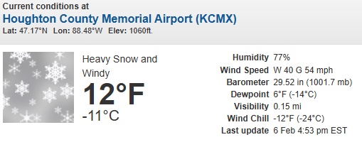
MTU / Houghton MI Blizzard Warning:
-
PL/ZR event. Nothing overly exciting. Models showing snow here were wrong.
-
Thankfully there is hope to at least get some covering with this next system. I still have a glacier IMBY but a nice fresh covering would be nice!!!
-
Very nasty icing here this evening. My driveway was covered by 1/8" of ice. We had heavy fog and drizzle all day. Now that temps are below freezing the past several hours with RH still around 100%, the driveways and back roads have become horrible.
-
Ditto here with snow cover length. We lost half today. Now havea solid 2-3" glacier.
-
And we underperformed here with expect highs in the mid-40s but only got to 38.


