Lightning
-
Posts
1,182 -
Joined
Content Type
Profiles
Blogs
Forums
American Weather
Media Demo
Store
Gallery
Everything posted by Lightning
-
I was in the Keweenaw during that storm and the winds being like tropic storm conditions. If I recall correctly the LP went right over Houghton. I also remember being very jealous of the Duluth area's snowfall!!!
-
The night of the 12th I tried but there were a few contrails all in that area. Don't know if I saw it or not After that it was cloudy until the past couple nights in which I keep being a bit to late (the moon was too bright). Gonna try again tonight.
-
We have a lot of pockets in MI that temps vary easily. I live in one of the cooler areas in SE MI. 10 miles/16 kms from my house typically is 3-5 degrees warmer.
-
Ignore feature works great
-
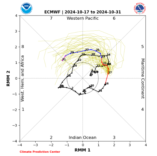
There might be some hope if this holds:
-
Hey Josh @michsnowfreak, Do you know what is the sunniest fall (% clear)? You are much better at stats than I around here! We have got to be close if not in the lead!! This September and August combo so far has been incredible.
-
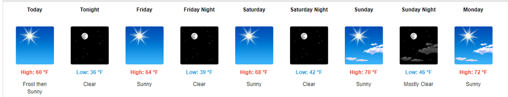
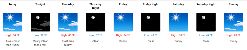
If it isn't going to storm then this is perfect for October for MBY:
-

Fall/Winter '24 Banter and Complaints Go Here
Lightning replied to IWXwx's topic in Lakes/Ohio Valley
I love all the model shows!!! Used to annoy me but now I look forward to the craziness. -
Enjoy! Getting a little over here too from Huron.
-
1.5" total for the weekend. Looks like we are going back to a bit of dry pattern after today (don't mind in October). Hopefully get a freeze one of the next couple mornings.
-
Today I surpassed 1" total for this event. This is the most rain I have seen fall from the sky since driving August 5 from North Dakota, Minnesota to La Cross WI.
-
While the Thunder has been south of here. We have had a steady rain now for a couple hours. I haven't seen something like this since early August while in La Crosse WI.
-
Looking pretty good for at least some rain around here tonight. Nice storms over LM right now. Hopefully they don't drop just to my south (something that happens commonly).
-
We have been viewing them here. Not as strong as the May event so far. Very glad I live out in the boonies so we can star gaze. EDIT: Just had a really nice wave of Aurora go through with some great colors. Especially lots of reds.
-
Aurora looking very probable tonight!!!
-
Absolutely wonderful Space Weather year.
-
How do you know the surface weather is boring? Most of our recent posts are about Space Weather
-
Looks like Sunday is going to bring in something other than endless sun and mild temps!!
-
Yeah it was brief but much better than nothing last night. My niece in Alaska sent some awesome pictures north of Anchorage last night!! Last couple days I have been using my eclipse glasses to see the Sunspots as a couple have visible to the naked eye with the right protection of course!!!!!
-
Fall/Winter '24 Banter and Complaints Go Here
Lightning replied to IWXwx's topic in Lakes/Ohio Valley
My wife HS friend lives in Sarasota. Maybe I could convince them for you to be a house sitter ... -
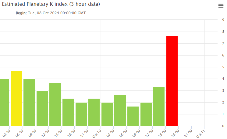
K-index has been increasing. Some areas should be seeing the Aurora. Unfortunately clouds have moved in here for a bit. Hopefully they will move out sooner than later!
-
Last night was very quite. Unfortunately it is not looking so good but there remains some hope for tonight:
-
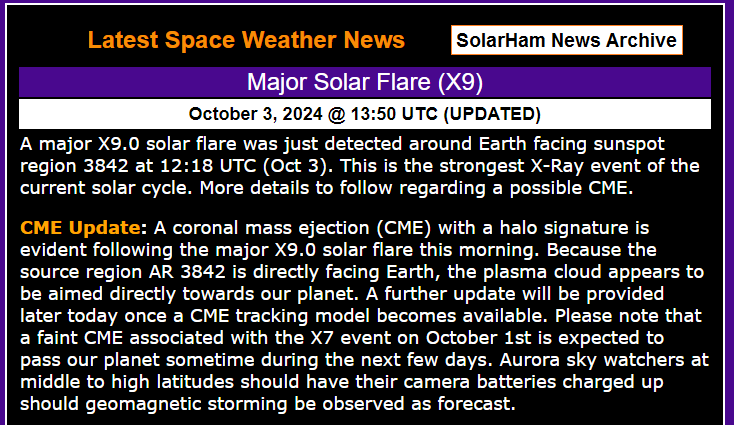
Aurora are always hard as the incoming data is very limited until they start but there are a lot of positives for this event. The sunspot position and CME timing was basically perfect as it was directly earth facing when it occurred. Plus there was a good CME with it that looks like it was directed at earth. The event from a few days ago seems slower as nothing yet from it but it still possible tonight. The coming event I would not predict it to beat the May one, but it definitely could as the May sunspot was not in very good position as it was about to rotate out of view the next day. This ranks as #15 in the top measure events using X-ray flux. 14 X-ray flux measured events greater than this one. Most of them the CME's were not earth directed or only glancing blows at best. The ones more directed/Earth facing had CMEs that were mainly not directed toward Earth with one of them the CME was pretty weak. Don't get me wrong some did produce good Aurora so I am not knock them. I love this stuff!! I am really look forward to it but know to keep tempered expectation with Aurora
-
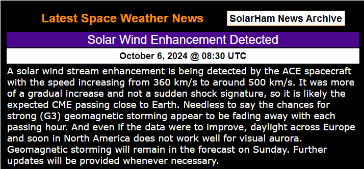
I was watching this unfold today and thought some would like to know. From Solarham.com:
-
Top notch stretch weather into the first weekend of October: