

Lightning
-
Posts
1,182 -
Joined
Content Type
Profiles
Blogs
Forums
American Weather
Media Demo
Store
Gallery
Everything posted by Lightning
-
I think he meant 11/24/31
-

November 2024 General Discussion
Lightning replied to SchaumburgStormer's topic in Lakes/Ohio Valley
I'll buy what the 12Z GFS is selling.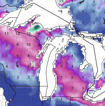
-
If you are looking for all three month DJF to be below normal temps and above normal snowfall. Yep it has been over 5 years as the last below normal December's was 2017. 2017-18 was a remarkable winter around here as Flint broke it all time record snowfall. I can say my last decent winter IMBY was 21-22 was well above normal snowfall with both Jan. 22 and Feb. 22 being cold and snowy. Keep in mind lots of cold doesn't always equate to lots of snow. 1995-96 with it cold DJFM (all 4 months were below normal). Yet snowfall was abysmal with most of it coming in March. Detroit ended '95-'96 with 27.6" which is just a few inches more snow that Super Nino winter of 1997-98 @23.5" and last year's 22.6". Like you, I much prefer it to be both cold and snowy However I will take mild and snowy/stormy over cold and dry!!
-
November 2024 General Discussion
Lightning replied to SchaumburgStormer's topic in Lakes/Ohio Valley
It was interesting to see a good westward & stronger trend with this system after seeing so many be faster and weaker in recent months/years. -
November 2024 General Discussion
Lightning replied to SchaumburgStormer's topic in Lakes/Ohio Valley
My total is now up to 1/2". Yeah, thankfully many areas in MI did well. Once the significant shift west with this system occurred in the models, the results are actually better then I expected. Many times, I have seen these MO/IA/WI flooding rain events produce nothing more than a clouds and drizzle IMBY. -
November 2024 General Discussion
Lightning replied to SchaumburgStormer's topic in Lakes/Ohio Valley
I have maybe 0.29" for the entire event so far. -
November 2024 General Discussion
Lightning replied to SchaumburgStormer's topic in Lakes/Ohio Valley
Here is an interesting Climo fact: Nov. 1975 (Edmond Fitzgerald sunk on the 10th) and Detroit had 1/2 the month 60F++. Then around the last week of the month we had a couple cold days and snow. Month was way above normal temps and way above normal snowfall No worries; it is coming. I would rather get a great pattern change and lock in for the most part, rather than a 1-2 week pattern change and then go right back to crap. -
November 2024 General Discussion
Lightning replied to SchaumburgStormer's topic in Lakes/Ohio Valley
November is not a 'winter' month. Yes winter weather happens and there are some great historic November events. If your expectations is for solid winter weather you are going to be greatly disappointed with November. -
November 2024 General Discussion
Lightning replied to SchaumburgStormer's topic in Lakes/Ohio Valley
I have a friend that pretty much, if there is grass showing, he is golfing. Yes he will golf in the 20s & 30s!!! Not me, honestly 60s are my lower limit. -
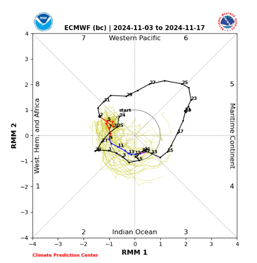
We definitely 'cooled' from where we were. Obviously there was not a cross polar flow but rather Canadian air that moved in the end of last week. The reality was that Canada was not 'cold' just cooler. Now the MJO is going down to COD. Our current pattern is reflecting that and the Pacific jet is ruling the roost!! Slam storms into west coast of Canada and we are not going to be cold!! MJO is my go to metrics when moderate/strong for the pattern (but you surely can't ignore other factors). The MJO near/in COD means look elsewhere for what driving the pattern.
-
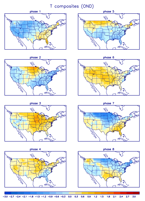
Phase 2-3 are not cold phases in November & December while phases 7-8-1 are best for cold in November & December for MW & GLs. I put the MJO temp correlation for OND below. Correct!
-
MJO:
-
November 2024 General Discussion
Lightning replied to SchaumburgStormer's topic in Lakes/Ohio Valley
Drove through there in September. It was truly Exceptional!! -
November 2024 General Discussion
Lightning replied to SchaumburgStormer's topic in Lakes/Ohio Valley
I have been very busy that past couples days and the models have shifted significantly west with the rain. My QPF for the next 3 days gone from a few inches to a few hundredths of an inch!!! Good part is today I can get more leaves mulched up with some nice mild temps -
Are you saying those 110F models runs were inaccurate for our area???
-
Wow, awesome!! Would have love to get something like that. Of course it helps that my backyard can't flood, well unless Noah type rains occur.
-
Okay but really, I don't see a conversation about an Arctic air intrusion into this region in the next 10 days. No one said it was no longer going to be mild or warm. Seems logical to understand the pattern change being discussed is in reference to the fact it has been extremely dry with endless wall to wall sunshine and at least for the next few days we have a pattern with more storms and precipitation falling from the sky then most have seen in 2-3 months.
-
This is the time of year the jetstream wavelength begins to change. This is why there are times a great pattern can fizzle to a crappy one and visa versa when not much else seems to change. I do like it getting wetter as wetter ground seems to help. Harry (occasional poster who will come around as winter gets going) is very big on wet grounds and storm tracks during winter. Based on his points I do tend to agree there are time storms tracks are influnced by wetter grounds. Obviously there is a lot more to it, many other factors can change that will definitely influence the teleconnections and patterns. I know you have recently moved to this area. Hope your expectation is not for November to be an amazing winter month, you will be disappointed. Most Novembers in my 50+ years in the the Great Lakes have about a week of winter like weather and 3 weeks of mild weather fall weather (yes some with occasional very warm days is nothing new).
-
I put my outdoor lights up last weekend (due to my schedule). I typically turn them on Thanksgiving week.
-
It really looks like we are finally seeing the breakdown of the pattern we have been stuck in since August. Pacific is now throwing a lot of big storms into Alaska area over the next 10 days or so. It is going to take awhile for it to lock into anything desirable here until some level blocking in that area can get established. Let's just hope any blocking is positioned well for us to get fun winter weather.
-
I like the sound of this for you: Really hoping to hear some great reports from you later today into tonight!!!
-
3 days in a row of 30-40MPH wind gusts expected. This will help remove many of the leaves from the trees. Oaks and Norway Maples, as usual, will be the trees with the last leaves standing!!
-
The wall to wall sunshine has been amazing and enjoyable for sure. Definitely looking forward to it becoming more active. It was very nice hearing rain this morning. Plus I am ready to be done with the bugs/beetles; while they have decreased, I want them gone!!
-
Couple boomers this morning
-
Didn't get anything exciting here but then again I was never expecting anything exciting Especially considering no model was shows much of anything anyways.


