Hurricane Agnes
-
Posts
8,581 -
Joined
Content Type
Profiles
Blogs
Forums
American Weather
Media Demo
Store
Gallery
Everything posted by Hurricane Agnes
-
Amazing. Generally had light rain yesterday until after ~9:30 pm last night when it unleashed. Ended up with 2.43" yesterday and an additional 1.00" since midnight at post time, for 3.44" so far for the event. That's a month's worth of rain in about 8 hours. Hearing about the flooding of the Schuylkill Expy from 476 --> Belmont this morning! Currently 56 with light rain.
-
Surprising high of 79 today after a low of 53. Just had a couple heavy showers (no severe and not much wind) that deposited 0.17". Currently looking at a rainbow to the east with the temp down to 61 with the sun popping out.
-
Ended up with 0.43" of rain yesterday and currently have 0.2" today as of post time. Temp stayed steady @ 52 overnight and currently 52 and overcast.
-
It'll definitely go over 1/4" where you are (I just hit 0.28"). The stuff is moving in from both the W and the SE (the 2 flows seem to be clashing right along the Lancaster/Chester County line). Also think it may just get close to that 49 mark. That high up in Canada means some business! Am flirting with 52 now.
-
Was out at a recital in Elkins Park this afternoon and it started raining there (and here) sometime after 5:30 pm. Am gobsmacked that it is currently 53, after a midnight high of 72. Have been getting old fashioned steady rain since. Up to 0.18" for the day so far (most of that from this evening).
-
Get a beer and some nachos to go along with that and you're all set.
-
That's so funny. Was just thinking of you because it feels like fall out there! Temp crept up to 64 here but that breeze is still gusty.
-
Picked up an additional 0.13" overnight just before midnight for a total of 0.41" yesterday. Got a brief shower this morning for 0.01" and getting some gusty SE winds. Had a high earlier today (just after midnight) of 72 but the temp continued to fall and it is now down to 61 with overcast.
-
My sister in Wyndmoor a few miles from me said (and I quote) "Where's the rain? I only got 10 drops". My other sister in Upper Darby was out at the King of Prussia Mall and said she saw it get dark with lightning, went to dinner at a restaurant there, and when she was ready to leave, she found it had rained. But then she said it was dry when she got home in UD. It's a tale of pop-up storm "dots" and I was under one for about 15 minutes.
-
Got 0.28" out of that and it dropped the temp down 10 degrees to 73. Currently overcast and steamy with dp in low 70s.
-
Almost at 4:30 pm on the dot, a couple thunders and the sky has gotten dark. Temp hit a high of 86 today and currently 83 with incoming something (although it looks like the cell is east of me moving out of the NE to the SW). Edit to add - now getting some huge droplets, almost like small hail that melted just before reaching the surface.
-
Judging by the plants and walks, some light rain came through here this morning but not enough to tip the bucket. Currently 78 and overcast, with breaks of sun here and there. There was a good amount of sun earlier (about an hour ago) but that sortof disappeared.
-
Made it up to 85 today after the clouds finally burned off. Currently 79 and mostly cloudy with sunset a few minutes away from this post time.
-
Had 0.32" overnight just after 12:30 am. Currently 75 and overcast with the sun making an attempt to break through. Humidity is awful with dp in the 70s.
-
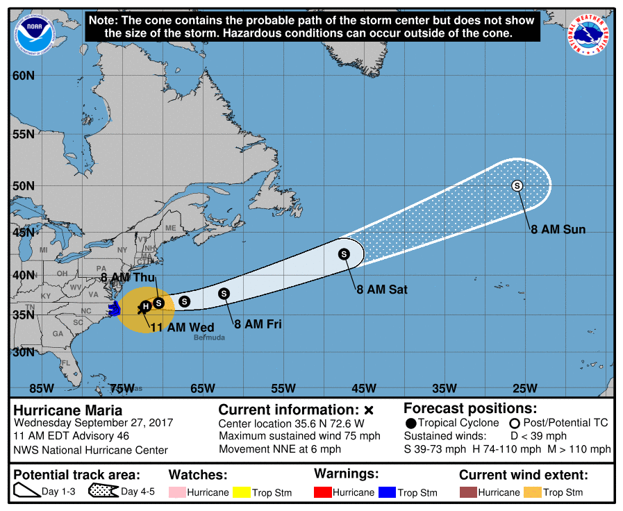
Maria back to a minimal CAT 1 again (and Lee now a CAT 3) - 000 WTNT35 KNHC 271448 TCPAT5 BULLETIN Hurricane Maria Advisory Number 46 NWS National Hurricane Center Miami FL AL152017 1100 AM EDT Wed Sep 27 2017 ...MARIA TURNS NORTH-NORTHEASTWARD... SUMMARY OF 1100 AM EDT...1500 UTC...INFORMATION ----------------------------------------------- LOCATION...35.6N 72.6W ABOUT 165 MI...265 KM E OF CAPE HATTERAS NORTH CAROLINA MAXIMUM SUSTAINED WINDS...75 MPH...120 KM/H PRESENT MOVEMENT...NNE OR 15 DEGREES AT 6 MPH...9 KM/H MINIMUM CENTRAL PRESSURE...978 MB...28.88 INCHES Updated cone -
-
Well Maria is now officially a Tropical Storm. 5pm update - ZCZC MIATCPAT5 ALL TTAA00 KNHC DDHHMM BULLETIN Tropical Storm Maria Advisory Number 43 NWS National Hurricane Center Miami FL AL152017 500 PM EDT Tue Sep 26 2017 ...MARIA CONTINUES TO MOVE SLOWLY NORTHWARD... SUMMARY OF 500 PM EDT...2100 UTC...INFORMATION ---------------------------------------------- LOCATION...34.1N 73.0W ABOUT 160 MI...260 KM ESE OF CAPE HATTERAS NORTH CAROLINA MAXIMUM SUSTAINED WINDS...70 MPH...110 KM/H PRESENT MOVEMENT...N OR 360 DEGREES AT 7 MPH...11 KM/H MINIMUM CENTRAL PRESSURE...974 MB...28.77 INCHES Meanwhile Lee has intensified as a CAT 2 and forecast to possibly be a CAT 3 - a storm that all but dissipated just a week ago!
-
One part of the 5 pm discussion noted this - Maria is a large hurricane. Hurricane-force winds extend outward up to 105 miles (165 km) from the center and tropical-storm-force winds extend outward up to 205 miles (335 km). NOAA buoy 41002, located about 100 miles west-northwest of Maria's center, recently reported sustained winds of 44 mph (70 km/h) and a gust to 56 mph (91 km/h). She's not as big as Sandy was but I think as she weakens, she will expand further. The issue at this point is whether that kicker cold front actually gets to the coast when progged. It has been sitting almost stationary for the past couple days over the MW -
-
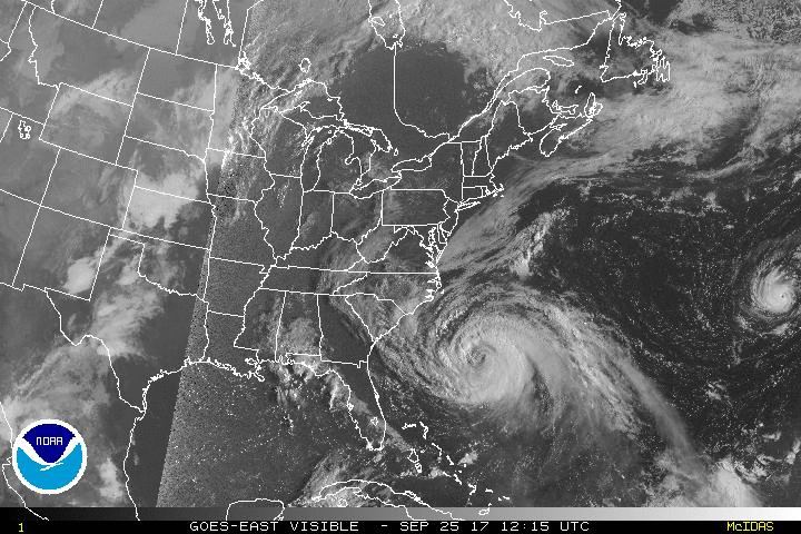
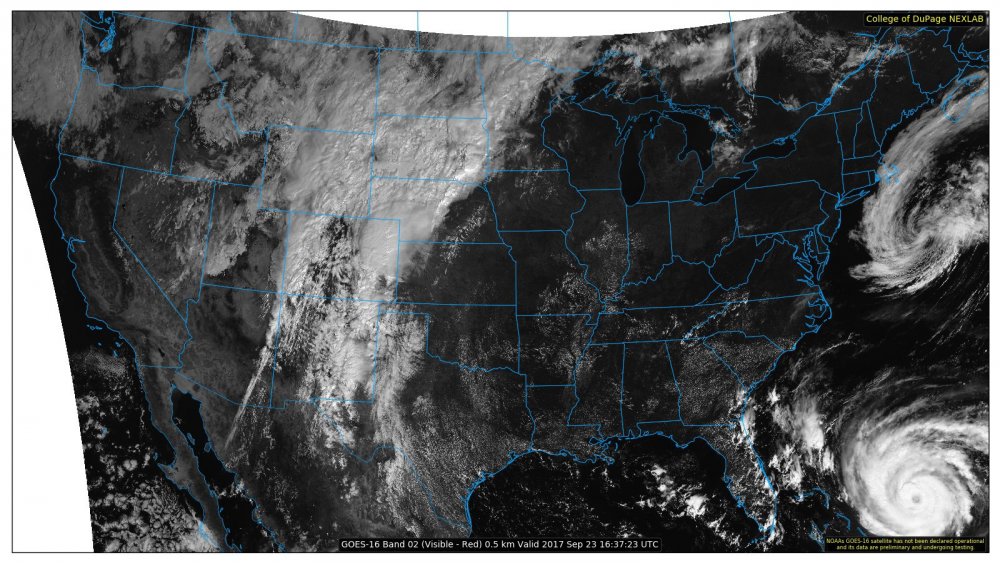
Looks like the coast is getting raked by the outer band and some of that band's clouds is reaching all the way up to NY & NE. Also a bit OT for the thread but I know the NHC has called Lee "tiny" and you can see why, despite the fact that his winds are currently a wee bit stronger than Maria's -
-
Wow. I wonder if TSJU can get repaired faster because I expect TJUA won't be fixed for a long time.
-
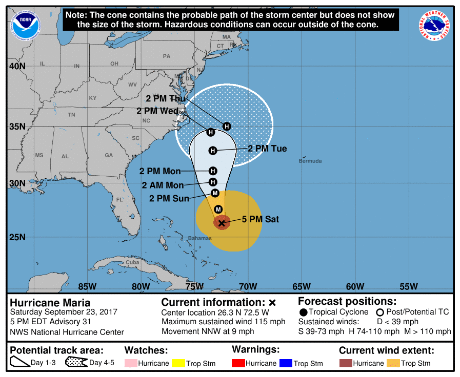
5 pm update (and the sharp right turn). She picked up a little speed but is still @ 115 mph sustained - ZCZC MIATCPAT5 ALL TTAA00 KNHC DDHHMM BULLETIN Hurricane Maria Advisory Number 31 NWS National Hurricane Center Miami FL AL152017 500 PM EDT Sat Sep 23 2017 ...MARIA CONTINUES NORTH-NORTHWESTWARD... ...INTERESTS ALONG THE CAROLINA AND MID-ATLANTIC COASTS SHOULD MONITOR THE PROGRESS OF MARIA... SUMMARY OF 500 PM EDT...2100 UTC...INFORMATION ---------------------------------------------- LOCATION...26.3N 72.5W ABOUT 285 MI...460 KM E OF GREAT ABACO ISLAND ABOUT 640 MI...1030 KM SSE OF CAPE HATTERAS NORTH CAROLINA MAXIMUM SUSTAINED WINDS...115 MPH...185 KM/H PRESENT MOVEMENT...NNW OR 345 DEGREES AT 9 MPH...15 KM/H MINIMUM CENTRAL PRESSURE...950 MB...28.06 INCHES
-
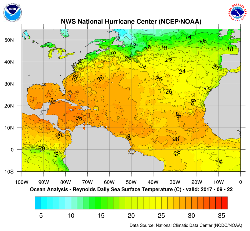
At this time of year (late summer/early fall) the ocean temps along the east coast are at their warmest (due to the lag of seasonal ocean warming). So during this time of year, the Gulf Stream isn't necessarily impacting the temps right along the coast north of NC. In fact, the current water temps all the way up to the NY area are in the low 70s, low-mid '70s off the Jersey coast, mid-70s off DE/MD coasts/bays, & mid/upper 70s off the VA/NC coasts - https://www.nodc.noaa.gov/dsdt/cwtg/all.html Winter/spring is a whole other ballgame however (same seasonal lag, so slow to warm in spring). Ugh.
-
That's a forecast/projected visualization of ssts (based on how CDAS works) vs actuals, no? If so, it seems it's giving Jose quite a bit of credit in upwelling the water off the central and upper midatlantic coast, which seems overdone. I.e., I can't see how the Jose remnants are going to have that kind of impact right along the coast all the way down into NC -
-
She still has some juicy water to run through (latest data as of yesterday) before hitting VA. Jose is further north and east of that area.
-
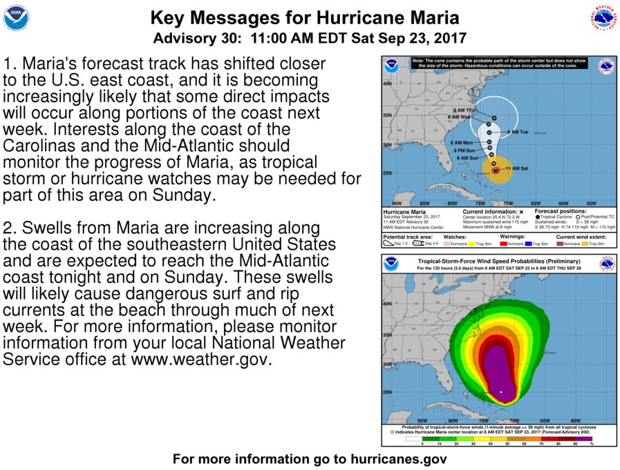
Key messages are of note here regarding the impacts on the coast due to the potential westward movement (and also due to her size and the outer bands) -
-
11 am position (winds have dropped) - ZCZC MIATCPAT5 ALL TTAA00 KNHC DDHHMM BULLETIN Hurricane Maria Advisory Number 30 NWS National Hurricane Center Miami FL AL152017 1100 AM EDT Sat Sep 23 2017 ...DANGEROUS SURF AND RIP CURRENTS EXPECTED AT SOUTHEASTERN UNITED STATES BEACHES FOR THE NEXT SEVERAL DAYS... SUMMARY OF 1100 AM EDT...1500 UTC...INFORMATION ----------------------------------------------- LOCATION...25.4N 72.3W ABOUT 245 MI...395 KM E OF ELEUTHERA ISLAND ABOUT 320 MI...515 KM E OF NASSAU MAXIMUM SUSTAINED WINDS...115 MPH...185 KM/H PRESENT MOVEMENT...NNW OR 340 DEGREES AT 8 MPH...13 KM/H MINIMUM CENTRAL PRESSURE...952 MB...28.12 INCHES