

Hurricane Agnes
-
Posts
8,578 -
Joined
Content Type
Profiles
Blogs
Forums
American Weather
Media Demo
Store
Gallery
Everything posted by Hurricane Agnes
-
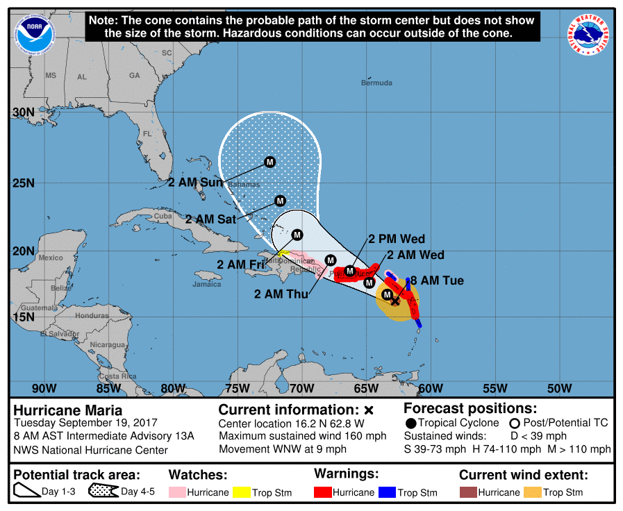
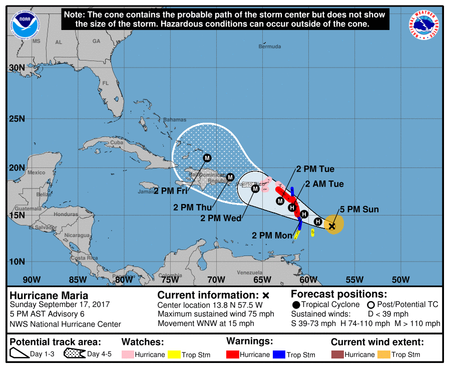
ZCZC MIATCPAT5 ALL TTAA00 KNHC DDHHMM BULLETIN Hurricane Maria Intermediate Advisory Number 13A NWS National Hurricane Center Miami FL AL152017 800 AM AST Tue Sep 19 2017 ...POTENTIALLY CATASTROPHIC HURRICANE MARIA HEADED FOR THE VIRGIN ISLANDS AND PUERTO RICO... SUMMARY OF 800 AM AST...1200 UTC...INFORMATION ---------------------------------------------- LOCATION...16.2N 62.8W ABOUT 85 MI...135 KM W OF GUADELOUPE ABOUT 170 MI...275 KM SE OF ST. CROIX MAXIMUM SUSTAINED WINDS...160 MPH...260 KM/H PRESENT MOVEMENT...WNW OR 300 DEGREES AT 9 MPH...15 KM/H MINIMUM CENTRAL PRESSURE...933 MB...27.55 INCHES
-
8 pm update -
-
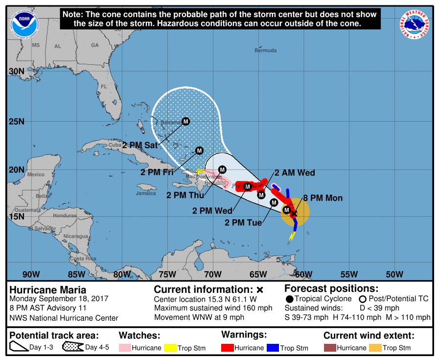
ZCZC MIATCPAT5 ALL TTAA00 KNHC DDHHMM BULLETIN Hurricane Maria Special Advisory Number 11 NWS National Hurricane Center Miami FL AL152017 800 PM AST Mon Sep 18 2017 ...MARIA BECOMES A POTENTIALLY CATASTROPHIC CATEGORY 5 HURRICANE... ...THE EYE AND THE INTENSE INNER CORE IS NEARING DOMINICA... SUMMARY OF 800 PM AST...0000 UTC...INFORMATION ---------------------------------------------- LOCATION...15.3N 61.1W ABOUT 15 MI...25 KM ESE OF DOMINICA ABOUT 40 MI...70 KM N OF MARTINIQUE MAXIMUM SUSTAINED WINDS...160 MPH...260 KM/H PRESENT MOVEMENT...WNW OR 300 DEGREES AT 9 MPH...15 KM/H MINIMUM CENTRAL PRESSURE...925 MB...27.32 INCHES They went with the 925 mb.
-
Latest interim positional update -
-
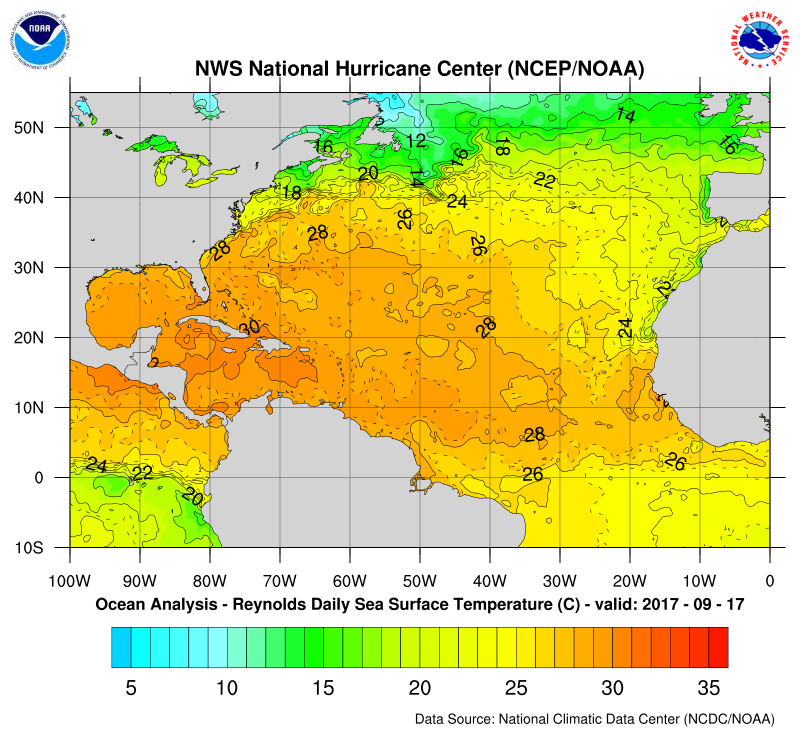
That area that it is headed for right around Hispaniola is really bathwater -
-
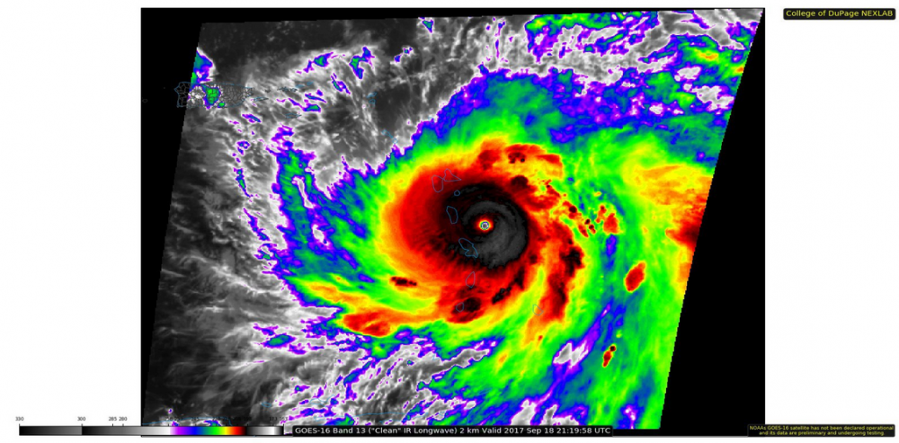
GOES-16 IR (from about 5 minutes ago) -
-
She's officially upgraded (as noted in an earlier post) -
-
I think because of incidents like this (1/26 - 1/27/15) - http://www.philly.com/philly/news/Meteorologists_apologize_for_busted_forecast.html Many were hugging the Euro and dissing the lowly GFS - http://www.philly.com/philly/blogs/weather/Snow-What-went-wrong.html I think that is why today, you are seeing folks bemoaning the rise and fall of the mighty Euro.... and as much as we laugh about being "NAM'd", I expect that sometimes the NAM does have the right idea but with the details obscured in the overdoneness of a burnt steak on the barbie. You can hunt around and find the pbp thread(s) here in the forum of that 2015 flizzard.
-
Maybe GOES-16 will help (or not) - https://www.nesdis.noaa.gov/GOES-R-Launch Still a ways off from what impact that will have in the future, but it will have some just due to the resolution of its instruments. I think a lot of what we see today is also driven by the 24/7 world where schools, businesses, and governmental entities increasingly demand precise measures in order to activate certain responses to the more severe sensible weather (i.e., closures, postponements, evacuations) and that leads to model-hugging in order to tease out those numbers and report them as soon as possible. However we have seen time and time again a long range model "see" something 10 days out and then lose it in the mid-range, and then resurrect it again in the short range/nowcast period. IMHO, that type of whiplash seems to cause some to overthink or lose the forest for the trees. Overall, I doubt at this point that "weather" for mass consumption will ever go back to appealing to met fans. TWC used to do it but long sense decided to leave that niche world and go for drama over substance.
-
Attention All Philly Subforum Members
Hurricane Agnes replied to Rjay's topic in Philadelphia Region
The true story (need to go to youtube to view) - -
Attention All Philly Subforum Members
Hurricane Agnes replied to Rjay's topic in Philadelphia Region
When a storm threat is on the horizon, folks reappear rather quickly and do some great pbps of the models. The past year, winter weather lovers got a screw job. There is just a different climatological thing going on here compared to D.C. or NYC metro. -
Attention All Philly Subforum Members
Hurricane Agnes replied to Rjay's topic in Philadelphia Region
The "pile" will make itself. Won't need to shovel to create one with this storm. -
Attention All Philly Subforum Members
Hurricane Agnes replied to Rjay's topic in Philadelphia Region
There you are! People thought our resident squirrel fled to chase a blizzard elsewhere! -
Attention All Philly Subforum Members
Hurricane Agnes replied to Rjay's topic in Philadelphia Region
Because this - Almost 37 years ago I had to make a decision during college orientation on whether to major in meteo (a love since I was 8) and chemistry (something I was aceing in HS). And due to the mimimal job prospects back in the late '70s for meteorologists, I chose chemistry as the practical major because it offered more work options. I am on track to retire next year after 30+ years. Coming to boards like this, I got direct or link access to all sorts of resources - including models and working meteorologists - allowing me to digest someone's analysis - whether red-tagger or meteo student or "advanced" hobbyist, and then do a check on what I thought I saw and compare - just by reading. Part of the problem that happens here is that the minute someone makes an attempt at a model analysis and gets it "wrong", a pile-on ensues, the degree of which dependent on how bold and perhaps (overly) confident they were when they wrote it. And the "wrong" may have been something not really weenie but truly due to lack of experience, etc. Of course this naturally requires thicker skin but sometimes it encourages big ego posters rather than those brave enough to post and hope for a mature critique. So many of us just enjoy lurking and contributing obs or occassional opinions after review of model runs to help fill in the climatological info on the area -whether ahead, during, and post storm (or even during "quiet" periods) while we engage in our hobby. Many of us also post on other forums (including non-meteo ones) so it's not like we are all here 24/7. As it was during the eastern days, there are folks who are winter/cold-lovers and were thus absent during the summers and vice versa, with those who like severe/tropical and participate more during those seasons. But if the Admins here want to close the board to red-taggers and students only, then so be it. In the past, the single-region threads often filled up quickly during storms and there was a battle on who would start (and when) the "new thread"... as well as other nonsense of chasing people out of the regional threads who were not from there and other childish bull****. Otherwise some of you all protesteth too much. -
Attention All Philly Subforum Members
Hurricane Agnes replied to Rjay's topic in Philadelphia Region
Wow. I usually try to check in often to see what is going on and just saw this thread. There are quite a few of us who do more lurking than posting but we are here (and yes, some of us are paying members ) and when events happen, we usually pop up and chime in. But given the more benign weather patterns of late, it's been relatively quiet in here. I think after past years of threats that became a big fail and other issues like wacked-out models that caused municipal over-reactions. etc.), plus this year's El Nino handwriting-on-the-wall, then I think that's why it seems dead (with less banter and model posting). But if you look in past threads when storms were imminent and/or on-going, there has been a lot of good discussion without all the weenie and left-field bravado posts. IMHO, the microclimates here (Delaware Valley) really are a bit different, being a blend between Mid-Atlantic and NYC and I do appreciate the folks in this region providing "heads-up" posts as storms move from west -> east or south -> north. Unless the admins think this is a waste of their resources, then I don't see why it can't remain the way it is. -
He declared a state of emergency in preparation for the Pope (who was not setting foot in NJ). lol Although in all seriousness, that low that was south of here off the coast spinning for days plus the cold front and stuff about to run up the front, has been tearing up the beaches (none of that due to Joaquin). It's just sad.
-
PHL: biggest snowfall of the winter
Hurricane Agnes replied to famartin's topic in Philadelphia Region
I had an old pic of me and my sister after the blizzard of '66 (we had on Yogi Bear boots ), which I think was a 12"er. After that, '67 - '77 (1st grade --> sophmore in HS) was essentially a snow drought. Decent sleddng conditions were few and far between. First decent snowman was crafted in '78. But then senior class trip to the Poconos in January '79 resulted in 40s and rain that weekend. I think in comparison, the past 5 years have been pretty phenomenal for snow lovers. -
He has a twitter feed here - https://twitter.com/larrycosgrove I don't do twitter but will occasionally look at public feeds...

