Hurricane Agnes
-
Posts
8,576 -
Joined
Content Type
Profiles
Blogs
Forums
American Weather
Media Demo
Store
Gallery
Everything posted by Hurricane Agnes
-
8 am updates - ZCZC MIATCPAT5 ALL TTAA00 KNHC DDHHMM BULLETIN Hurricane Maria Intermediate Advisory Number 21A NWS National Hurricane Center Miami FL AL152017 800 AM AST Thu Sep 21 2017 ...MARIA'S LARGE EYE PASSING OFFSHORE OF THE NORTHEASTERN COAST OF THE DOMINICAN REPUBLIC... SUMMARY OF 800 AM AST...1200 UTC...INFORMATION ---------------------------------------------- LOCATION...19.9N 68.7W ABOUT 95 MI...150 KM NNW OF PUNTA CANA DOMINICAN REPUBLIC ABOUT 190 MI...305 KM SE OF GRAND TURK ISLAND MAXIMUM SUSTAINED WINDS...115 MPH...185 KM/H PRESENT MOVEMENT...NW OR 315 DEGREES AT 9 MPH...15 KM/H MINIMUM CENTRAL PRESSURE...959 MB...28.32 INCHES
-
Sorry - the link was still pointing to the old one. Am uploading the image (including it here as well) -
-
The convection has fired up again within the past couple hours with a band that has pushed back into the island from the west with some large blobs in it (plus lightning has ratcheted up as well - https://www.lightningmaps.org/?lang=en#y=18.1396;x=-66.5121;z=7;t=3;m=sat;r=0;s=0;o=0;b=0.00;n=0;d=2;dl=2;dc=0;) -

-
8pm summary - ZCZC MIATCPAT5 ALL TTAA00 KNHC DDHHMM BULLETIN Hurricane Maria Intermediate Advisory Number 19A NWS National Hurricane Center Miami FL AL152017 800 PM AST Wed Sep 20 2017 ...CORE OF DANGEROUS HURRICANE MARIA GRADUALLY MOVING AWAY FROM PUERTO RICO... ...CONDITIONS NOW DETERIORATING OVER EASTERN DOMINICAN REPUBLIC... SUMMARY OF 800 PM AST...0000 UTC...INFORMATION ---------------------------------------------- LOCATION...18.9N 67.5W ABOUT 55 MI...90 KM ENE OF PUNTA CANA DOMINICAN REPUBLIC MAXIMUM SUSTAINED WINDS...110 MPH...175 KM/H PRESENT MOVEMENT...NW OR 305 DEGREES AT 12 MPH...19 KM/H MINIMUM CENTRAL PRESSURE...958 MB...28.29 INCHES
-
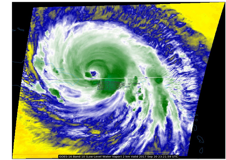
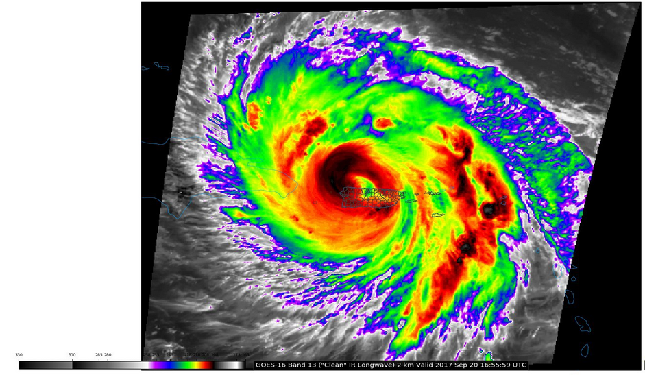
She's transforming! The eye is clearing -
-
The large eye looks to be clearing out. But my focus there was more on the convective complex over PR. We no longer have visible to see the individual training cells which was our next best thing besides radar. The complex is troubling. Oh I know... That has been rolling across there all day. If you look at the WV images, that band has been building and expanding NW -> SE for some time and you can see why the river/stream gauges are choking. You can loop the water vapory images (LL & ML) here - http://weather.cod.edu/satrad/exper/?parms=meso1-10-200-0-100
-
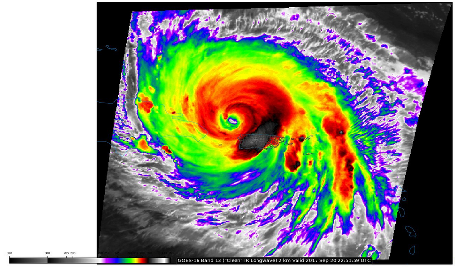
But also seeing the inner eye opening after looking at the loop here - http://weather.cod.edu/satrad/exper/?parms=meso1-13-200-0-100 Recent image -
-
I assumed "flood" for that abbreviation but it does have a link to the term! Instantaneous and Daily Value Status Codes --------------------------------- Code Description --------------------------------- Ssn Parameter monitored seasonally Bkw Flow affected by backwater Ice Ice affected Pr Partial-record site Rat Rating being developed or revised Eqp Equipment malfunction Fld Flood damage Dry Dry Dis Data-collection discontinued -- Parameter not determined Mnt Maintenance in progress ZFl Zero flow *** Temporarily unavailable Thanks for confirming! I think many of the gauges across the island are going through similar failures. We saw that with Harvey for the gauges in and around Houston and how they failed.
-
This is the USGS site link for that gauge - https://waterdata.usgs.gov/nwis/uv?site_no=50043800 The last update was about 2 hours ago (I know different gauges report out at different intervals). The one thing notable is the cumulative rainfall noted at the USGS link (> 17" so far).
-
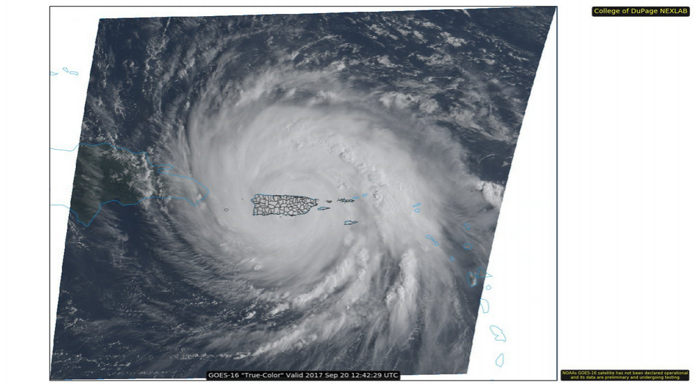
This is what she looked like a couple minutes ago -
-
USGS deployed some sensors along the southern coast to collect data (haven't seen any data uploaded yet) and they have a nice page where you can zoom in and hover over markers to see flow data/conditions at various spots around the island - https://www2.usgs.gov/water/caribbeanflorida/hurricane_maria.html
-
10 am update (she is moving at a pretty good clip) -
-
There was someone streaming from Trujillo Alto (SE of San Juan) and the winds had died down considerably. He claimed that they were probably under the eye (or perhaps they were under some gap).
-
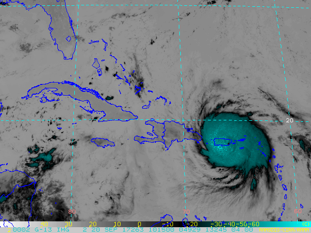
Whole island engulfed by Maria -
-
Updated NHC statement - 000 WTNT65 KNHC 201034 TCUAT5 Hurricane Maria Tropical Cyclone Update NWS National Hurricane Center Miami FL AL152017 635 AM AST Wed Sep 20 2017 ...MARIA MAKES LANDFALL NEAR YABUCOA PUERTO RICO... Geostationary satellite images and surface observations indicate that the center of Hurricane Maria made landfall near Yabucoa, Puerto Rico, around 615 AM AST. A sustained wind 60 mph (96 km/h) with a wind gust to 113 mph (182 km/h) was recently reported at Yabucoa Harbor, Puerto Rico. A National Ocean Service tide gauge at Yabucoa Harbor, Puerto Rico, recently reported a water level of 4.3 ft above Mean Higher High Water (MHHW). SUMMARY OF 635 AM AST...1035 UTC...INFORMATION --------------------------------------------------- LOCATION...18.0N 65.8W ABOUT 20 MI...35 KM WSW OF VIEQUES ABOUT 35 MI...55 KM SE OF SAN JUAN PUERTO RICO MAXIMUM SUSTAINED WINDS...155 MPH...250 KM/H PRESENT MOVEMENT...NW OR 305 DEGREES AT 10 MPH...17 KM/H MINIMUM CENTRAL PRESSURE...917 MB...27.08 INCHES $$ Forecaster Berg
-
Shortwave really shows the IEW contraction -
-
He is in San Juan - He said they were locking the hotel doors so he would have to decide in or out and would end up outside to broadcast when possible -
-
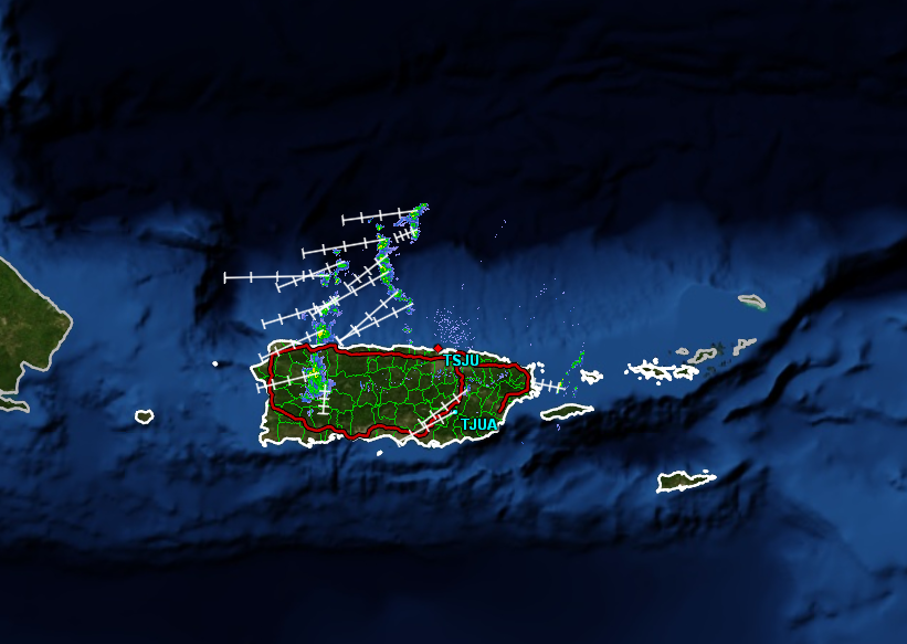
TSJU isn't transmitting either from what I can tell... I think it has been undergoing an ERC and has wobbled but yeah, it seems to have wobbled west and then WNW.
-
Yeah I think it's dead. Last image I got from it -
-
Jim Edds able to get some SJN vid out within the past minute (and that is not even near the eye which should be land-falling now) -
-
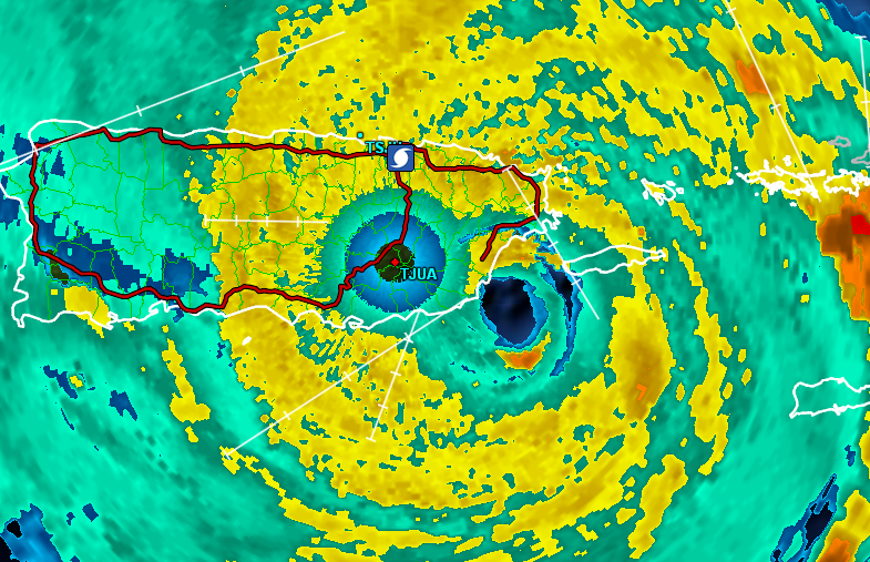
Looks like landfall happening/imminent -
-
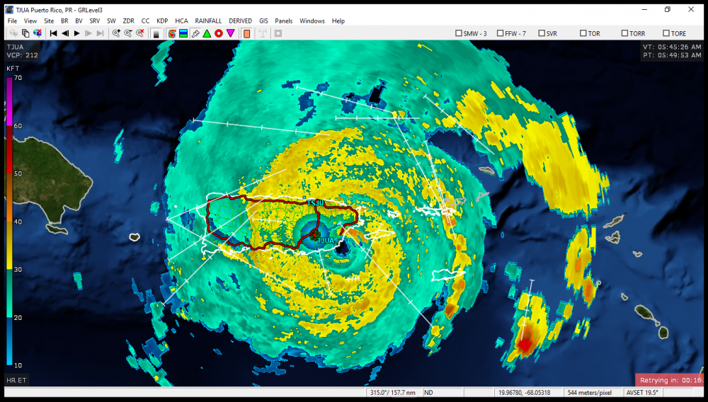
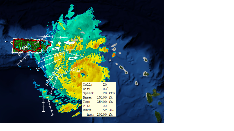
GRLevel3 example of that right around the eye -
-
The 7 pm interim update had it at that - The 8 pm kept it the same - 000 WTNT35 KNHC 192357 TCPAT5 BULLETIN Hurricane Maria Intermediate Advisory Number 15A NWS National Hurricane Center Miami FL AL152017 800 PM AST Tue Sep 19 2017 ...EYE OF CATEGORY 5 HURRICANE MARIA MOVING CLOSER TO ST CROIX IN THE U.S. VIRGIN ISLANDS... ...PREPARATIONS AGAINST LIFE-THREATENING STORM SURGE AND RAINFALL FLOODING AND DESTRUCTIVE WINDS SHOULD BE RUSHED TO COMPLETION... SUMMARY OF 800 PM AST...0000 UTC...INFORMATION ---------------------------------------------- LOCATION...17.0N 64.2W ABOUT 60 MI...100 KM SE OF ST. CROIX ABOUT 160 MI...255 KM SE OF SAN JUAN PUERTO RICO MAXIMUM SUSTAINED WINDS...175 MPH...280 KM/H PRESENT MOVEMENT...WNW OR 300 DEGREES AT 10 MPH...17 KM/H MINIMUM CENTRAL PRESSURE...909 MB...26.84 INCHES
-
I just fired mine up and it is there (v2.6).
-
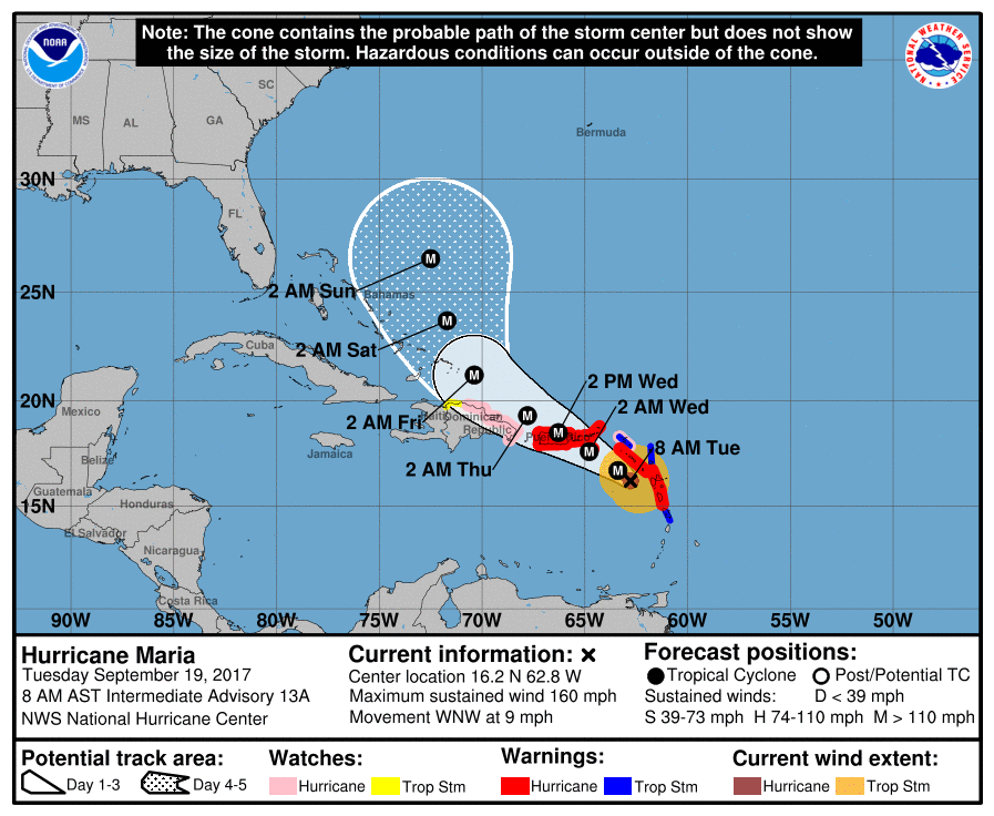
ZCZC MIATCPAT5 ALL TTAA00 KNHC DDHHMM BULLETIN Hurricane Maria Intermediate Advisory Number 13A NWS National Hurricane Center Miami FL AL152017 800 AM AST Tue Sep 19 2017 ...POTENTIALLY CATASTROPHIC HURRICANE MARIA HEADED FOR THE VIRGIN ISLANDS AND PUERTO RICO... SUMMARY OF 800 AM AST...1200 UTC...INFORMATION ---------------------------------------------- LOCATION...16.2N 62.8W ABOUT 85 MI...135 KM W OF GUADELOUPE ABOUT 170 MI...275 KM SE OF ST. CROIX MAXIMUM SUSTAINED WINDS...160 MPH...260 KM/H PRESENT MOVEMENT...WNW OR 300 DEGREES AT 9 MPH...15 KM/H MINIMUM CENTRAL PRESSURE...933 MB...27.55 INCHES