Hurricane Agnes
-
Posts
8,976 -
Joined
Content Type
Profiles
Blogs
Forums
American Weather
Media Demo
Store
Gallery
Everything posted by Hurricane Agnes
-
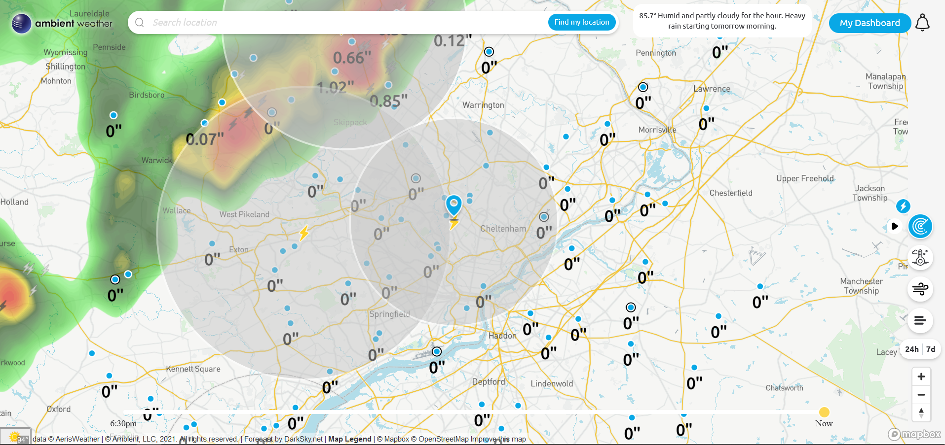
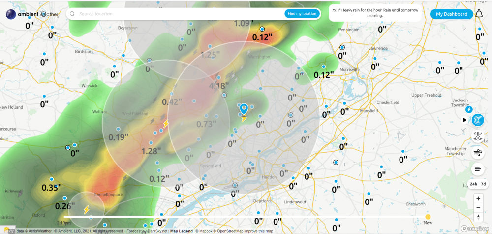
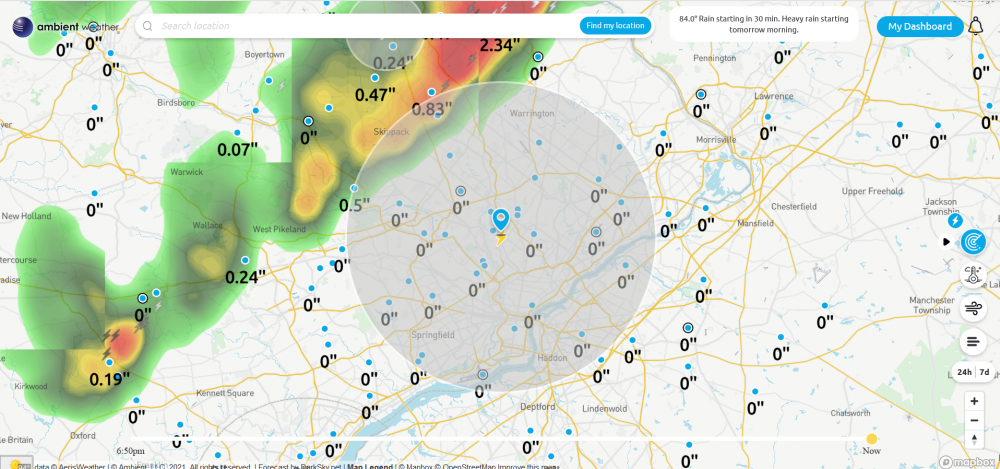
Gully washer with over 2.5"/hr rates. Am up to 0.71" so far for the day at post time.
-
Finally getting under the heavier rain. Currently at over 3/4" an hour and am up to 0.26" for the day so far. Temp down to 73,
-
The leading edge of it is finally here but it hasn't completely come over me yet. Temp is down to 78 with dp 73 and lightning detectors in the area capturing it.
-
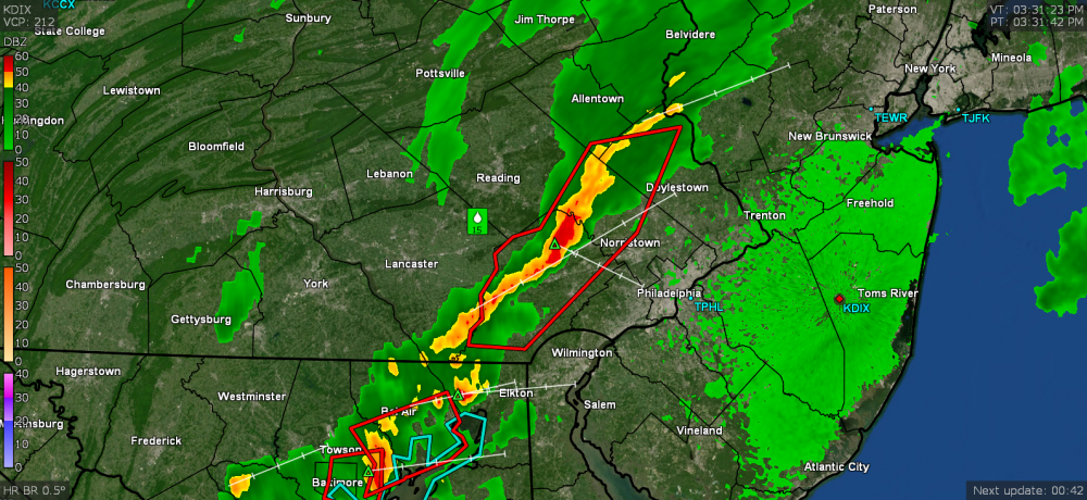
After that first round was done, the sun came out during the gap and shot me back up to 83 before the clouds came in again and knocked the temp back down a bit. Currently overcast 81 with dp 72. Incoming line looks solid and a Warning was issued for parts of the metro area.
-
SPC just lofted Severe Thunderstorm Watches - Current temp here is down to 77 with dp 73, and I have picked up 0.11" rain so far from the initial little round.
-
I finally got a little measurable! 0.05" (so far). Me take. I'm now down to 78 (dp 72) with the rain but hit the 86 at 10:50 am according to my station data. I know there is a FF Watch up so whatever heavier stuff comes later this afternoon and supposedly into tomorrow, will cool the asphalt streets and brick/stone buildings!
-
Was looking at Levi Cowan's last video before what would be Elsa became a TS and he was noting that the sheer was actually lower than normal this early in the season, so that gives it a better chance to stay alive, assuming it doesn't shift and run across the islands, and then that would tear it apart as a weak TS. Hope he can get an updated one up soon! My high this earlier morning was 86 before the cloud cover took over and dropped the temps. Currently 83 with dp 71 and some incoming. Hopefully what looks like a possible 1st round won't fizzle like last night's little attempt.
-
So far my low this morning has been 73 and it's currently 73 with dp "down to" 70. Ended up getting nothing measurable last night. Since May, I have hit 90 and above 11 times (9 of those days in June).
-
Finally getting some thunder and damp sidewalk but nothing measurable yet. Temp is down to 78 with dp 72. Looks like Center City and South Philly have a pop up blob.
-
Looks like the big fizzle. Stuff is showing up over me but except for some initial large splats, nada. Temp is down to 79 with dp 71. I think Bucks County got the bulk...
-
Need something on the dusty leaves!
-
That gust front turned the sky jet black. Hasn't arrived here yet but am watching it incoming. Temp ticked down to 87. Dp has dropped a tiny bit to 72. ETA - gust front coming through now. Temp down to 85 w/dp 71.
-
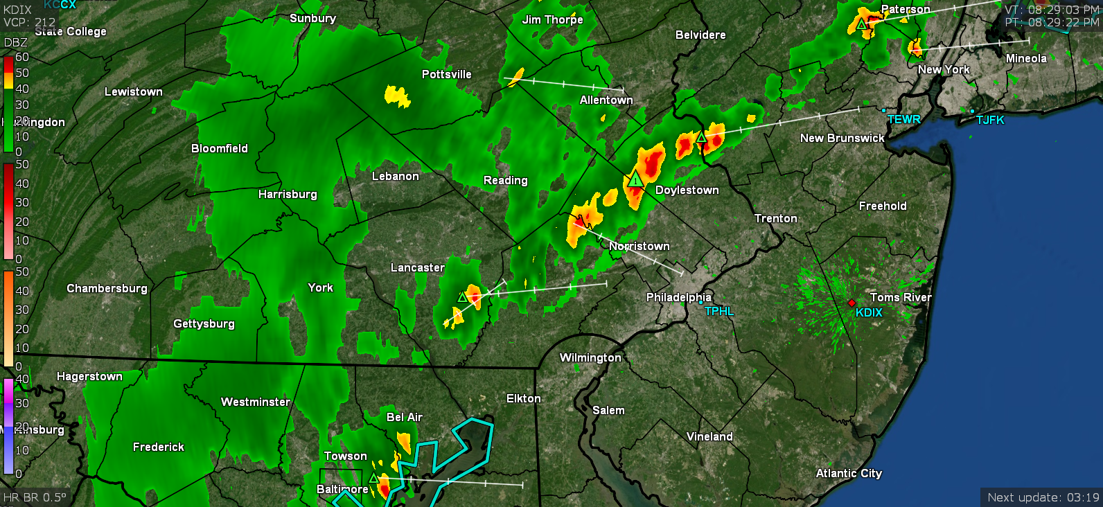
My little lightning detector is picking up the line (snapshot from about 5 minutes ago)...

-
There's an incoming line and some huge towering cumulus that I have been looking at to my west (with a layer of cirrus right above them). Temp is "down to" 88 and the dp is a more manageable 73. lol There is a more active breeze so that is mixing some of it. Hope I can cash in on a little rain tonight ahead of whatever is proggred for tomorrow afternoon.

-
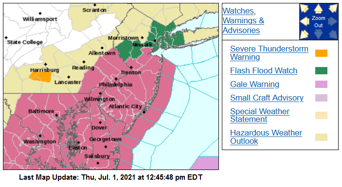
Flash Flood Watch just issued for tomorrow - Temp has been bopping between 95 and 96 here with dps shifting between 73 - 74 and still mostly sunny with some clouds trying to get going. There's some stuff forming way up north and west.

-
Just hit 96 with dp bopping between 75 and 74 whenever a puff of a breeze appears. My station's "Feels like" temp says 106.9... lol). The cumulus have rolled in and will see if that eventually offers any ground shading.
-
I have a nice soft electric blanket with multiple heat settings for a toasty comfortable snooze. Meanwhile I just hit 95 and that dp is still up there at 75.
-
Just briefly hit 93 at 11:55 am with a dp that was supposed to be "lower" today but instead, is bopping between 76 and 77.
-
Had a low of 75 earlier, with a "lower" dp of 71, but am now up to 82 with dp going right back up to 75. I had to get some water on the plants earlier this morning and hope it will hold them until the progged showers Thursday/Friday. Was glad to have had the little ground-wetting pop-ups last Saturday but that couldn't make up for these temps. It's been interesting to note that I've had just over 5 3/4" rain for the month of June (since this is the last day, although will see if anything pops up this afternoon).
-
Hopefully not that McDonald's scorcher type. Looks like 94 was my high today and even the puffy clouds had had enough and disappeared. Currently 90 and yes, the dp has actually dropped to 72. I think what moisture was left in the ground has evaporated, and that plus an active light breeze helped to mix some of the stagnant air (at least in relative terms, dropping the dews from the upper 70s down to the low 70s).
-
I briefly tapped 94 with a dp of 78. That has bubbled up the cumulus big time so the sun is going in and out. Currently at 93 with dp moving between 77 & 78.
-
It didn't steam but then it could be the central air didn't cycle off either so the windows never got a chance. I have hit 91 as a high so far this morning, and am currently bopping between that and 90 with a disgusting 77 dp (refuse to even open the door).
-
Had my low of 74 just before sunrise and am off to the races and currently at 77 with dp 74. This morning there wasn't even an opportunity for stratus to form, so it went right to unimpeded sun at sunrise.
-
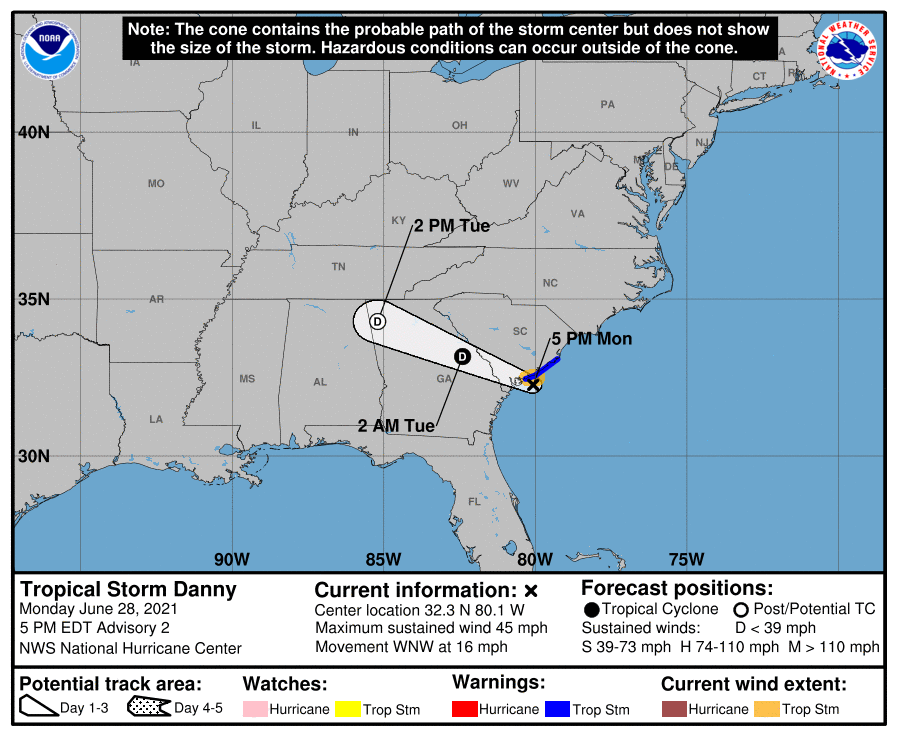
I know there was some earlier speculation in the AFDs but Mt. Holly decided to loft the Excessive Heat Warning for the metro area in conjunction with the Advisory around the outer parts of the metro. Probably due to that dp not really mixing out. And then abracadabra, up pops another east coastal TS! Danny was suddenly born with an outsized role - to go over the coastal goal line as a TS. Currently a hazy, hot, and humid 90 with dp bopping between 74 and 75.
-
So far holding at 93 for a high today and currently bopping between 91 and 92 for a current, but with a dp that genreally hasn't gotten off the 75.