Hurricane Agnes
-
Posts
9,264 -
Joined
Content Type
Profiles
Blogs
Forums
American Weather
Media Demo
Store
Gallery
Everything posted by Hurricane Agnes
-
I still have some slides somewhere of me and my younger sister standing in front of the garage door holding shovels and sporting our new Yogi Bear snow boots surrounded in snow!
-
E PA/NJ/ DE Winter 2021-22 OBS Thread
Hurricane Agnes replied to JTA66's topic in Philadelphia Region
This! We got the leftovers that fizzled coming across here last night but OMG. As an obs, my high may end up being 47 and it's currently partly sunny and 46 with dp 22. -
E PA/NJ/ DE Winter 2021-22 OBS Thread
Hurricane Agnes replied to JTA66's topic in Philadelphia Region
Latest RERs from Mt. Holly for Dec. 11 - So far I bottomed out to 40 this morning and have crept up to 41 with dp 28, which is a far cry from yesterdays 60 dp. Ended up with a total of 0.26" of ran yesterday as a combo of the morning and evening showers. -
E PA/NJ/ DE Winter 2021-22 OBS Thread
Hurricane Agnes replied to JTA66's topic in Philadelphia Region
Getting some strong wind gusts coming through attm so this may be the front. Temp is down 58 and dp is way down to 50 and falling. Still getting some light rain (with 0.26" so far today). -
E PA/NJ/ DE Winter 2021-22 OBS Thread
Hurricane Agnes replied to JTA66's topic in Philadelphia Region
Getting moderate rain, just over 1/4"/hr - 1/3"/hr but nothing extra windy beyond what has been going on the past couple hours. Looks like the line broke up over me. Not picking up any convection either. Have 0.25" total in the bucket so far. Temp is 60 with dp 59.
-
E PA/NJ/ DE Winter 2021-22 OBS Thread
Hurricane Agnes replied to JTA66's topic in Philadelphia Region
STS issued.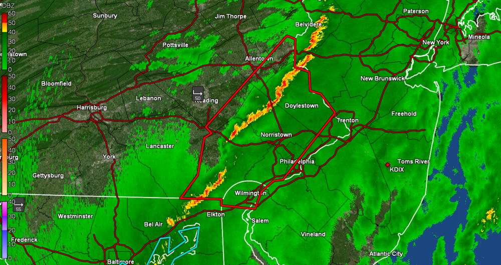
-
E PA/NJ/ DE Winter 2021-22 OBS Thread
Hurricane Agnes replied to JTA66's topic in Philadelphia Region
Looks like the convective line is reforming as it is approaching the area. Am getting some light rain here (had 0.10" earlier this morning from the morning round) and am now up to 0.12" for the event so far. Temp is 62 with dp 59.
-
E PA/NJ/ DE Winter 2021-22 OBS Thread
Hurricane Agnes replied to JTA66's topic in Philadelphia Region
There's a Wind Advisory up for the entire state and I have been watching the line as it moves across and it looks like it has diminished a bit but then it might do its final downsloping as it approaches the area by maybe midnight, and re-fire into a stronger line. SPC DY1 has us still as "marginal" - And I agree that it has been pretty gusty the past couple hours but the temps have held in the mid-60s too. It's currently 64 with dp a juicy 61. -
E PA/NJ/ DE Winter 2021-22 OBS Thread
Hurricane Agnes replied to JTA66's topic in Philadelphia Region
Handful of RERs so far - My high so far today has been 64 and it stayed overcast the entire day, so no sun to heat it up. It's currently 64 and overcast with dp 60. -
E PA/NJ/ DE Winter 2021-22 OBS Thread
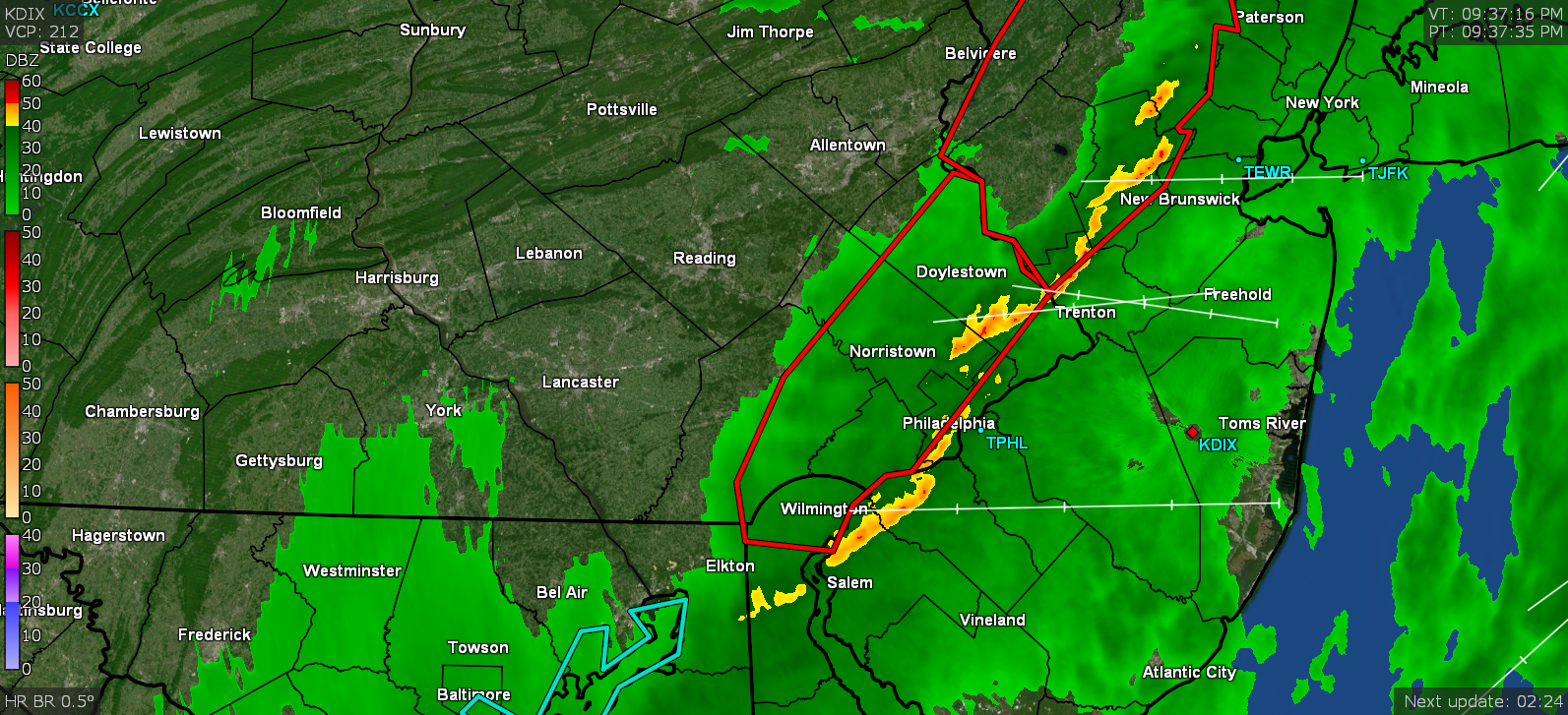
Hurricane Agnes replied to JTA66's topic in Philadelphia Region
Still overcast here but temp is up to 62 with dp 59. You can see the convective line just west of Pittsburgh with some antecedent band...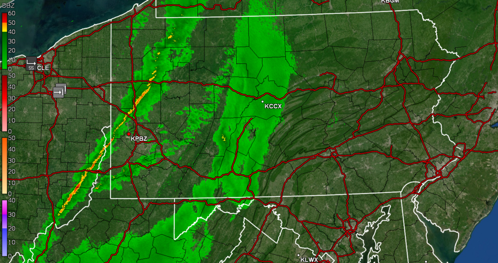
-
E PA/NJ/ DE Winter 2021-22 OBS Thread
Hurricane Agnes replied to JTA66's topic in Philadelphia Region
Got some dense fog here early this morning (vis. ~1/10th of a mile) until now, when it's starting to lift with the temps increasing. Low was 44 around 3 am and temps have been rising since. Currently overcast with stratus and mist and 55, with dp 54. -
E PA/NJ/ DE Winter 2021-22 OBS Thread
Hurricane Agnes replied to JTA66's topic in Philadelphia Region
SPC put the area in a marginal risk for DY2 - -
E PA/NJ/ DE Winter 2021-22 OBS Thread
Hurricane Agnes replied to JTA66's topic in Philadelphia Region
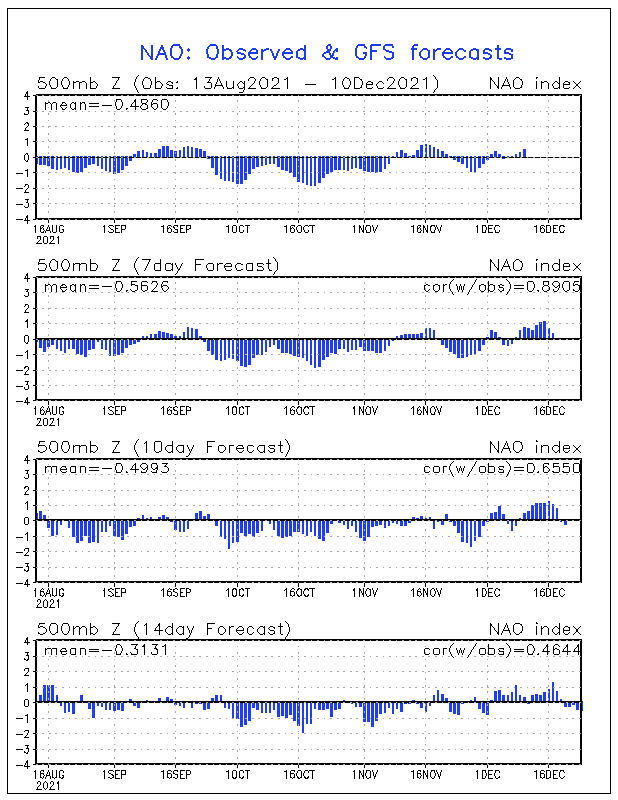
Maybe reflecting that the NAO is progged to go neutral or slightly negative in the long term (10 - 14 days).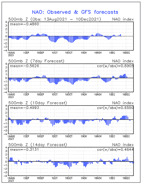
-
E PA/NJ/ DE Winter 2021-22 OBS Thread
Hurricane Agnes replied to JTA66's topic in Philadelphia Region
All kinds of stuff could happen with those squall lines. It will probably depend on how much heating is able to occur before the front arrives. More often than not, I have seen the cool air "bleed in" and stabilize the atmosphere around these parts (MBY at the higher elevations) but when it jumps over the river, all hell can break loose with the down slope. -
E PA/NJ/ DE Winter 2021-22 OBS Thread
Hurricane Agnes replied to JTA66's topic in Philadelphia Region
Interestingly enough, we see this sort of thing more in the spring than the fall but it's basically the same sort of dynamics (although for somewhat opposite reasons for those 2 seasons). I.e., spring has cold ground and warm air influxes and fall has warm ground and cold air influxes. Mother nature dictates that the temp/pressure must come into equilibrium somehow. I did see there was a tornado threat in the TN area. Currently overcast here and 38 with dp continuing to rise and at 32. -
Old Crappy Coatesville Snowfall Records!
Hurricane Agnes replied to LVwxHistorian's topic in Philadelphia Region
He mistakenly mixed you up with Dennis Nedry - But then all the Wayne Knights look alike so.... -
E PA/NJ/ DE Winter 2021-22 OBS Thread
Hurricane Agnes replied to JTA66's topic in Philadelphia Region
Wind Advisory lofted for Philly metro, as well as well north/south and east- Have so far had my low of 32 happen some time after 1 am and have been on the upswing since. Currently 36 with dp on the rise and currently at 30. -
E PA/NJ/ DE Winter 2021-22 OBS Thread
Hurricane Agnes replied to JTA66's topic in Philadelphia Region
Am a bit surprised but probably shouldn't be, that it stayed a bit colder here today than I expected. The low was 29 and high was 39 but we are closing in on the shortest days of the year... Even with the low dews through the day, am expecting the WAA to start coming soon though. Currently 36 with a dry dp 25. Did have a red sunset, so I guess that means something (maybe RedSky smiling at the brief but unexpected white stuff). -
Attention All Philly Subforum Members
Hurricane Agnes replied to Rjay's topic in Philadelphia Region
I thought the above was your "final word" but apparently not. Philadelphia is the 2nd largest city by population on the east coast. Full stop. Enough of the bullshit. -
E PA/NJ/ DE Winter 2021-22 OBS Thread
Hurricane Agnes replied to JTA66's topic in Philadelphia Region
Mt. Holly did a little ditty on December snow here - Coin flips (or probably something to do with ENSO states). -
E PA/NJ/ DE Winter 2021-22 OBS Thread
Hurricane Agnes replied to JTA66's topic in Philadelphia Region
You may have to host it somewhere and link to it or find a way to shrink/compress the size (maybe get it down to a lower resolution or edit it to run for a shorter amount of time). I know the different subscriptions here offer different file sizes permitted for each upload. -
E PA/NJ/ DE Winter 2021-22 OBS Thread
Hurricane Agnes replied to JTA66's topic in Philadelphia Region
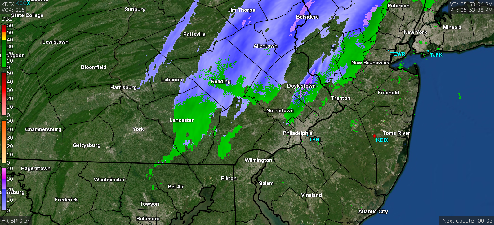
You guys made me get up and check and there be white pancakes coming from the sky! Temp at 37 but dp is up to 30 so the atmosphere has moistened enough to kill the virga.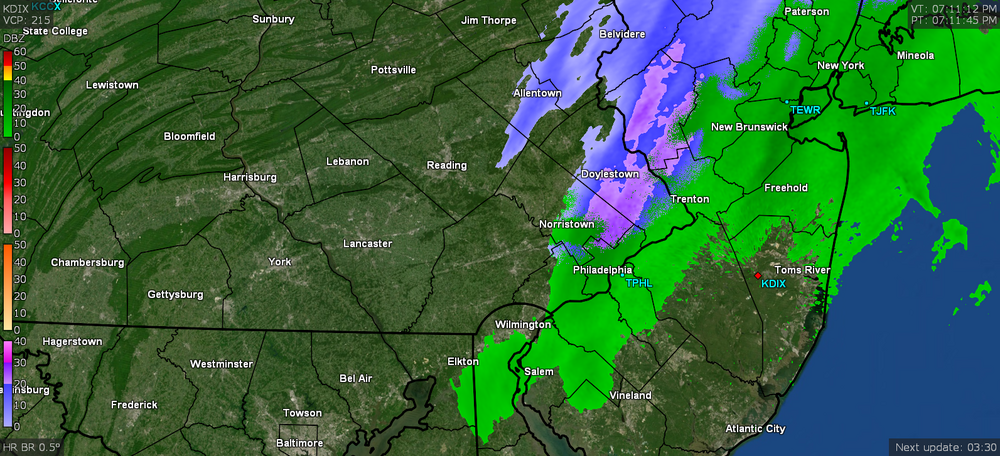
-
E PA/NJ/ DE Winter 2021-22 OBS Thread
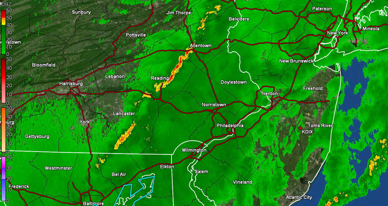
Hurricane Agnes replied to JTA66's topic in Philadelphia Region
Looks like upper Bucks got under something. Grabbed a snapshot of a heavier band not far from you... RedSky should be under some good stuff. It's too warm here (am at 37, although the dp is now up to 29).
-
E PA/NJ/ DE Winter 2021-22 OBS Thread
Hurricane Agnes replied to JTA66's topic in Philadelphia Region
That's not how they do "normal" temperatures. The climatology to determine what is "normal" is done over a period of many years. They may report out an "average" temp for the day as a somewhat meaningless stat, but they generally average the daily highs for each season over some period of years, and then do the same for the lows, and with that in hand, can come up with what might be considered typical ("normal" ). Similarly, USDA had been calculating their hardiness zones by averaging the lowest min winter temperature for each year over a period of from 15 - 30 years for different regions of the country and will then assign hardiness zones based on that to give gardeners some idea for what types of plants (trees, shrubs, etc) can be grown in different areas and have a good chance to survive the lowest temps (the zones designated on a 10 degree scale). -
E PA/NJ/ DE Winter 2021-22 OBS Thread
Hurricane Agnes replied to JTA66's topic in Philadelphia Region
Just a couple weeks too soon.