Volcanic Winter
-
Posts
1,674 -
Joined
-
Last visited
Content Type
Profiles
Blogs
Forums
American Weather
Media Demo
Store
Gallery
Everything posted by Volcanic Winter
-
Spectacular footage of a co-ignimbrite plume at Semeru volcano today, after a relatively large eruptive event: https://www.youtube.com/watch?v=1jNKG4AnzPY Now if we could get one that’s about 50x larger and up another 8-10km into the atmosphere (this topped out at 15km), we may have ourselves a winter yet boys!
-
Isn’t that just a resolution issue though? Because back then, they didn’t have the tools to observe the mechanism behind those patterns the way we do today. And I think there are plenty of examples of seasons that go back and forth, like last winter where January was a stark reversal from December.
-
Life is most definitely too short. While frugality has its place, I think enjoying some basics (like yaknow, heat) with your hard earned money is pretty reasonable. Mine’s on usually around 45. Thermostat usually in the mid 60’s until January ish, but our bedroom usually runs below thermostat temp. We have a nice down blanket in bed and snuggling for warmth is more fun anyway.
-
Your optimism is infectious.
-
Yep, was the same in the NYC thread. Suddenly we’re talking about Boxing Day Bowling Balls and getting high on the supply. Very guilty here. I’m sure you guys will do better than us regardless of how this evolves, but I’m really hoping the favorable progression toward the end of the month holds.
-
How does this compare pattern wise to last Dec? Was brutal, I remember, but don’t remember the individual components aside from the strong -PNA. I do recall last Dec was when I seriously started talking to my wife about moving north, lol. But then Jan was more than good relative to the outlook at the time. I believe flow was very progressive and we never had much blocking, so with the intense block coming up and hopefully less flexed -PNA by default we have more potential? Is that an adequate read?
-
Man, couple years with highest max in the low 40’s and even one that looks like 38? Strictly in climatological terms I was born too late, I should’ve been born before Krakatoa went kaboom. Edit: Just realized that’s only the first week of Dec, originally thought it was the entire month.
-
Perfect, EasternLI! I’m going to hold you personally responsible if this doesn’t pan out. Can I get your name, number, serial number…
-
I’m definitely aware of that, I just find this sort of stark differential fascinating and have a personal love of cold weather in general. My concern is more the apparent permanence of the SE ridge anymore. It’s a voracious apex predator these days.
-
Always appreciate these comparison tables Bluewave. 2010 sticks out to the point where it feels like it may as well have been 100 years ago, climatologically.
-
I mean, don’t crucify me but there was definitely hype building for “the period after the 5th.” So it does look like things have unfortunately evolved less favorably (if the latest guidance pans out) early - mid month but still with the potential intact for later in the month. I’ll take anything positive I can get, I’m a hardcore ride or die snow weenie. But I won’t say I’m not a little sad we may not see a more active and cold month in total. Maybe that was never really in the cards or maybe that’s so unlikely these days it’d be an actual unicorn. But hey, if we get something out of the potential around Xmas, that’s certainly amazing and I’ll be very happy (then). Until then please excuse my emotional rollercoaster .
-
Okay now my hype is starting to retrograde… Quick someone post another 50” weenie map, even if it’s hand drawn.
-
So it looks like Shiveluch is extruding a lava dome (think of it as a swelling bulge of hot but cooling / crusting magma that plugs up the crater), which as they swell are prone to collapse and explosive / pyroclastic events. This is similar to La Soufriere in 2020-2021 that extruded a massive lava dome that ultimately triggered a moderately large sub plinian to plinian eruption. VEI 4, a decent and visually spectacular event no doubt, but too small for climate impacts. Shiveluch just had a partial dome collapse that sent a pyroclastic flow 10KM away from the edifice. Pretty impressive but not directed upward to the stratosphere. I would imagine intermittent sub plinian blasts and dome collapse pyroclastic flows (lateral not skyward) would be the main threat here. But if the dome grows massive or something more destabilizes in the volcano, for sure we could get a bigger event.
-
Shiveluch has had several large eruptions in recent history, but I’m not sure it’s currently at risk of anything massive enough right now to have a major climate impact. I’m going to dive deeper into the unrest that’s prompting the influx of articles about it, because nothing a short while ago was really pointing to it having anything more than a continuation of normal activity levels. I could be wrong but will investigate further. With that said, a low end VEI 5 like St Helens or Bezymianny won’t cut it. You need a particularly gassy El Chichón style VEI 5 which doesn’t encompass every volcano that erupts that large, or more probably a ‘near VEI 6’ (8-9km^3 erupted volume) to Pinatubo level and above. Pinatubo was even relatively small for the strength of its volcanic cooling episode, but it was exceptionally gas laden and deposited something like 20MT of sulfur into the stratosphere (El Chichón was much smaller and released 7MT). Pinatubo also had a boost from another large mid level VEI 5 eruption at Cerro Hudson in 1991. It’s part size of the blast, part composition of the magma and expelled gasses. In general the bigger the event the more likely it is to impact the climate. Hunga Tonga only did about 1/40th the sulphur release of Pinatubo, and it was nearly as large (some publications actually have it as larger, interestingly enough). With respect to HTHH I’m much more interested in how the combined loading of a decent shot of volcanic ash and a large injection of water vapor influence the upper level dynamics. That article speaking about the intense stratospheric cooling observed in the SH after HTHH was very interesting. It showed correlative evidence that such cooling events in the SH (however not from volcanic events in other cases, might be a big point here) correlated to stratospheric warming in the NH and -NAO states. HTHH was a very interesting event and I’m curious to read some retrospective climatological analyses in a few years. It may have a hand in some things going on right now, or maybe not. Back to Kamchatka, you really need something incredibly massive to have a major volcanic winter. Something like the Kurile Lake eruption: https://en.m.wikipedia.org/wiki/Kurile_Lake This was similar to Tambora in 1815 (though likely a bit larger) which caused the major anomaly in 1816. Not to mention, the 1810’s were one of the coldest decades ever, partly influenced by another massive VEI 6+ eruption of unknown origin in 1808/9. And yes, two eruptions of that magnitude only a few short years apart is exceedingly improbable; but the ice cores don’t lie!
-
The sulphur infiltrates the stratosphere and spreads into the stratospheric aerosol veil fairly quickly. I can link you some information on this, will edit this comment. It takes a couple years for it to precipitate out and thus end the effect, but the impact can be IIRC within a few months. It really takes a large eruption though. HTHH was just about the right size but was very gas poor for several reasons (except water vapor which is different of course). Edit: Anyone interested, read these articles and pay attention to the included charts. Explains the process rather well. https://www.volcanocafe.org/ruminarian-v-get-your-coffee-youre-gonna-need-it-repost/
-
Think about where we were last year at this time and what we were facing. It was my first winter with you guys and I remember hours of doom scrolling as Dec rolled on. Considering Boxing Day is my favorite blizzard of my lifetime for many reasons (including because I spent it snowed in with my future wife in our new apartment), this is definitely an exciting feeling. Of course we may not get anything that major, but the fact that we potentially could is exciting enough. If a stratwarm does occur I wonder if that will be tied back to the major stratospheric cooling in the SH from Hunga Tonga, as per that article that circulated a while back. Maybe, maybe not. But I like where we’re at right now.
-
First flurries down in Toms River also! Didn’t last particularly long but it was very nice to be outside and see a few flakes falling - before Thanksgiving even!
-
She’s a comin’! Currently 35 here and has been dropping pretty steadily
-
Give me that cold white powder. My precious.
-
Feel like a kid in a candy store reading this thread right now. Barely two weeks ago I was getting off a plane walking outside of EWR with serious swamp-ass into a torch. Now it’s basically January in November with a serious winter pattern potentially unfolding? Cracking open my first good winter beer tonight. … and I’m ready to look back longingly at this comment when things switch gears again and it’s 60-70 degrees instead.
-
I got down to 28 in my cold little corner near the Pine Barrens. Warmed up to mid 30’s with the clouds overnight. All I’m asking for is a Dec holiday period where I’m not damn near in shorts. I don’t think that’s too much to ask. We’re due an interesting Dec, and this right now is a nice early start.
-
NJ is 2.9 degrees above pre-industrial temps according to what I was looking at earlier. While we don’t live in Maine neither do we live in South Carolina, historically NJ was not a particularly warm state. It’s all relative of course but climate change has significantly altered what we perceive as normal, especially here. Even just reviewing the daily averages for this area will help to reveal how off the mark we’re getting. Average low for my area right now is 34 degrees, and the daily low temperatures seem to be one of the worst impacted by the overall warming. It’s hard to articulate without emotional rambling, but I just find it to be upsetting.
-
This is understandable. I’m only asking for “normal” climo instead of 90% torch 10% slightly cool. Obviously there’s always variance and oscillation back and forth, but the pendulum is clearly getting stuck in one direction vs the other.
-
Don’t hope for a torch in November / Dec, man. It’s fine to prefer the warmer weather, I totally get it. But the direction our climate is heading, it’ll be torching quite enough at all times of the year. Try to enjoy and appreciate seasonal cool to cold for what it is when we can get it, I wouldn’t be making this comment if it were still October. Preferences aside, it’s very clear how much easier it is to torch around here than to go BN so you’ll very likely get your wish at one point or another. Conversely I feel like I’m straight praying every year to see proper snow that sticks and lasts for more than 48 hours.
-
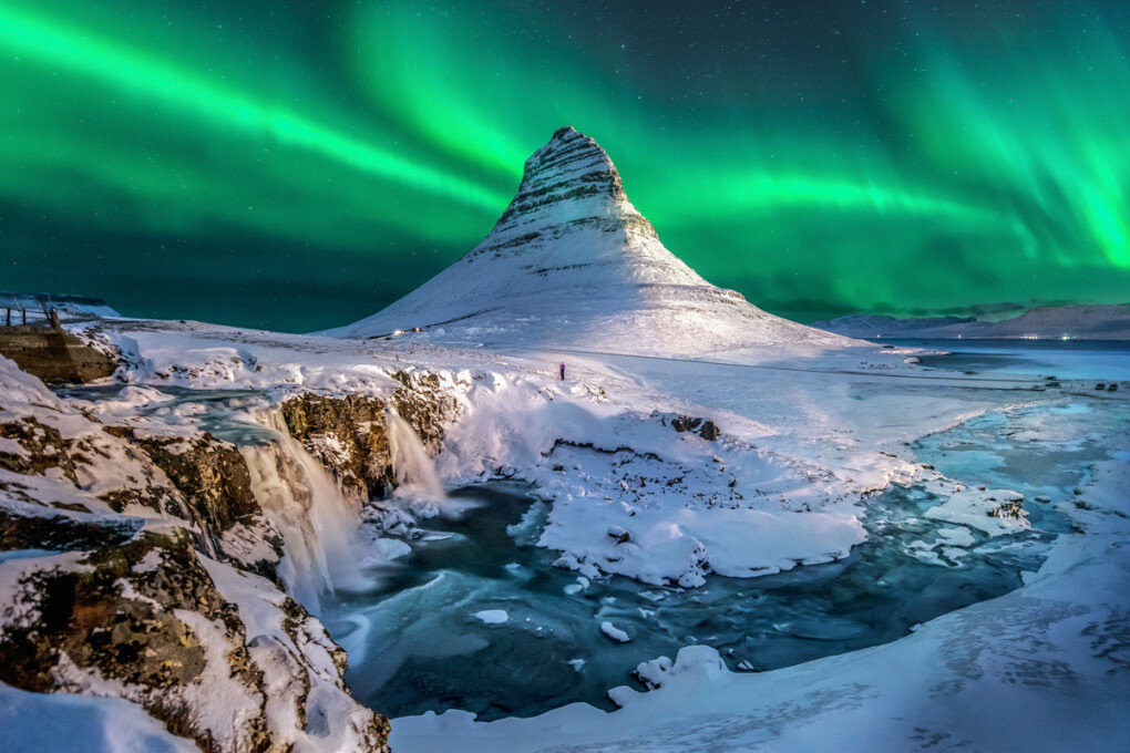
Flying home from my trip to Iceland right now, solid 24-44 degrees the entire trip (went to the northern region for most of it). Literally returning to a November furnace. Walking out of EWR in this type of airmass after acclimating to those temps for two weeks and with all of our stuff? Yeah no thanks. Man I leave for two weeks and you guys torch the place down.


