Volcanic Winter
-
Posts
1,674 -
Joined
-
Last visited
Content Type
Profiles
Blogs
Forums
American Weather
Media Demo
Store
Gallery
Everything posted by Volcanic Winter
-

New England Met Winter 2022-2023 Banter
Volcanic Winter replied to HoarfrostHubb's topic in New England
For my birthday in Feb, I’m trying to plan a predominantly hiking focused trip to New England / NNE. My wife and I are experienced winter hikers though we haven’t done much in the northeast US and am hoping to get out there and see some beautiful sights. I’m interested in locations around Mass, NH, or Vermont (Maine might be just a bit too far for our purposes right now) and I’m interesting in some recommendations for places to go focused on hiking. I gather this time of year the majority of mountain locales are geared toward skiing and snowboarding, which neither of us do anymore (used to Snowboard, unfortunately have had severe back injuries that took that from me). So I’m really unsure of what places would be ideal for hiking at this time of year. I’m totally open to any recommendations of any kind, my only ask is nice and broad; general “outdoors” . We do prefer day hikes to camping and would also love any cool towns to visit to stay, eat, and drink. We’re very well prepared for the cold and have suitable gear / clothing. Greatly appreciate any suggestions! -
This is already a statistically unusual start to winter as Bluewave points out below. I understand what the stats say, but this wasn’t a shutout pattern the way some of the other Decembers were where nobody in the northeast really saw snow (except the mountains I’m sure). The storm tracks missed the coastal plain of here and New England, but there were storms and there was snowfall in addition to BN anomalies for much of the month. That’s quite different to a shutout 50 degree month where snow was metaphysically impossible to begin with. Many of the years with no snow in Dec that went on to precede terrible snow-less winters had a much warmer pattern. Respectfully I’m going to disagree on calling the death knell on this winter. I have of course no way of knowing how things will end up, but let’s wait at least until we’re on the other end of this warm up and see what the pattern flip brings, along with the long range guidance at that time. If things are looking grim, sure.
-
Eh, at least IMBY we had quite a few upper 30’sh 25l days this month, that’s solidly below normal early - mid Dec if not outright cold. Given how warm Dec has been for us lately and how the month looks to be finishing up (give or take 37 at Central Park as per Bluewave back a page), overall that’s really not bad. We just missed the snow, but the month wasn’t a torch or anything. Impressively the torch to start the month was soundly erased.
-
Don’t start me up, I don’t stop once I get derailed into my biggest earthly passion . Yeah, the odds really aren’t that bad. You’ll typically see 2-4 VEI7 or very near 7 level events per millennium, and that number increases a bit more as you go a bit lower into the still incredibly large mid to upper end 6 range. And small to medium 6’s occur nearly every century, with the 20th having three VEI6’s with several more borderline 6’s. You really only need a borderline 6 like Pinatubo to impact the climate, assuming the volcano erupts a gaseous magma as Pinatubo did. And if you have a particularly stinky mid level 5 like El Chichon in the 80’s, you can even see a small negative anomaly from that. Borderline 5’s like St Helens are pretty much universally too small, though they can still be additive if coinciding with a larger event. It’s a little known fact that Pinatubo caused such a significant volcanic winter in part because Cerro Hudson erupted quite large the same year. Large events really aren’t all that rare, at least insofar as we can tell from the last thousand years which has much better resolution than prior. We also saw quite a number of large explosive events in the Aluetians and other poleward volcanoes in the early Holocene from the loss of ice and resulting containment pressure drop. I do believe we’ll see something similar as warming continues, though to a lesser extent than coming out of the LGM, at least initially. Hunga Tonga was spectacular though, erupted at or above borderline VEI6 level within an hour or two. Most large explosive events take days. That is monumental. Don’t forget, any (ahem) “volcanic winter” nowadays will just roll back several decades of warming for a couple years. Even if another Tambora went off tomorrow, the effects wouldn’t be as severe with respect to climate anomalies. It was already much colder then, so Tambora’s gargantuan forcing coupled with a much colder climate base state (not to mention the assist of another large event several years prior).
-
The fact that it was only “17th coldest” says quite a lot with respect to Bluewave’s post and my thoughts. This will be the coldest Xmas that many, myself included, have experienced in their lifetime.
-
Wow, that is so incredible… Seeing temperature data for Dec alone listed this way, makes it overtly clear how we lost Dec as a winter month. Look at the consistency of cold to very cold Decembers going way back! 40 was even an anomaly, now it’s what we should expect at minimum (it feels like, anyway). Again, how is this not monumentally depressing to people? Rhetorical, I know the reasons (including people don’t enjoy the cold), still this is so “in your face” major. One month, yes, but such an absolutely remarkable change from what was geologically a nanosecond ago. I need a Xanax after reading this.
-
And truly, I want to see a DJF with a -4/5 departure to mirror the occasions we torch to the opposite. Just to prove we can do it. C’mon Mother Nature, I dare ya!
-
Is there some relation between very warm summers and very cold winters? I’d assume if so in any measurable capacity it would’ve been more observable prior to the current era of accelerated warming, where just about every summer now is exceptionally warm. But I seem to recall a few years in the 1930’s too during the dust bowl era with some record warm summers and extremely cold winters. I think the 1910’s too, if I’m not mistaken? It’s been a minute since I’ve looked at total years, unsure of the 1910’s would fit this concept too. Side note, both decades featured large volcanic involvement.
-
I feel like I woke up to a second Xmas morning with this massive Bluewave data dump. Thanks man, I always spend a long time going over the temperature data you share and ponder different things / go on diversions looking up further details on specific winters and periods. The total scope and variation of our weather here in this area is fascinating. It is remarkably clear though, how the record low and high minimum max temperatures are clearly from a different era. I just don’t believe the NYC / NJ area will ever see another period with high temps in the low single digits and lows well negative. What would it even take to get there? Sure this current cold surge wasn’t in Jan during peak climo, but it was very clearly a powerful front with significant arctic air behind it. How much stronger could it get to force temps down even further? What else would factor in to produce even colder temps? Seems like we just about maxed out upon what is possible, though that is hardly scientific or anything other than a meaningless point of speculation. What else is remarkably clear; it takes an awful lot to produce BN departures these days, though without this current surge being bookended by pure torches in the beginning and end of the month would’ve probably gone a long way to producing a more significant departure. We’re not even going to finish Dec below normal relative to an earlier 30 year average, I gather. Now Jan will face a similar issue even if the remainder of the month is cold to very cold. Regardless, here’s to hoping we didn’t just experience all of the winter of 2023…in 2022.
-
Snow isn’t really guaranteed anywhere but the mountains. Even the coastal plain of New England is struggling, though of course they fair better than we do overall. It really comes down to the storm tracks as you point out, and everything that influences them.
-
60 is going to feel actually tropical next week after we all adjust to this level of cold. I do appreciate Lady Gaia saying, “I’ll give you a cold Xmas, but you can’t have New Years!”
-
Bottomed out at 7 degrees. Pretty impressive cold.
-
10.6 here now. (TR / Manchester border)
-
Right now we’re on “Empire Strikes Back,” just have to wait for the next installment, “Return of the Weenie.”
-
Looks great! Isn’t there a chance it would simply be virga due to falling through the dry arctic air? I don’t know, just asking. BTW 26 here in western Toms River. Dropped real fast and already feels quite cold with the wind.
-
Yeah on the upper level maps I looked at for the next two weeks it looks like no cold air at all on our side of the globe. Even Canada looks warm. What’s happening exactly to the vortex? Displaced to Asia? This is something I don’t understand as well. Thanks Forky.
-
The block linked up to the WAR and pushed the trough axis / storm track too far west into the Lakes. From my perspective it looks less like a wholesale pattern failure and more like a series of small misfortunes that cost us the storms. I’m most interested in seeing if we can shake the upcoming unfavorable PAC and get the block back in place for a round two at some point in mid to late January. I just can’t let myself believe this is going to be a skunk winter off bad luck in what otherwise was a good Dec (from pattern / temp perspective).
-
So the SST’s have been elevated for years over prior averages, what caused this linking to the WAR to occur now and not at other times? Is it the actual magnitude of the SST’s this year? Is it a poor omen for the future of negative NAO / AO patterns or perhaps more of just an anomalous occurrence with this one? If this were to become a recurrent feature of -NAO regimes going forward I would worry we’re currently entering an era of snow doldrums… Hopefully not.
-
Hopefully we see a resurgence later in the winter, that we capitalize on this time. Such a strong episode of blocking already does suggest a likely recurrence, yes?
-
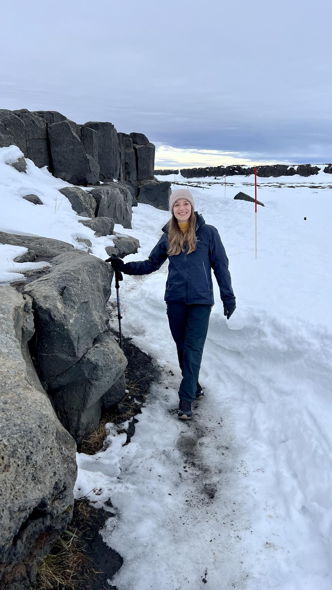
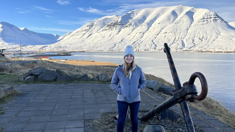
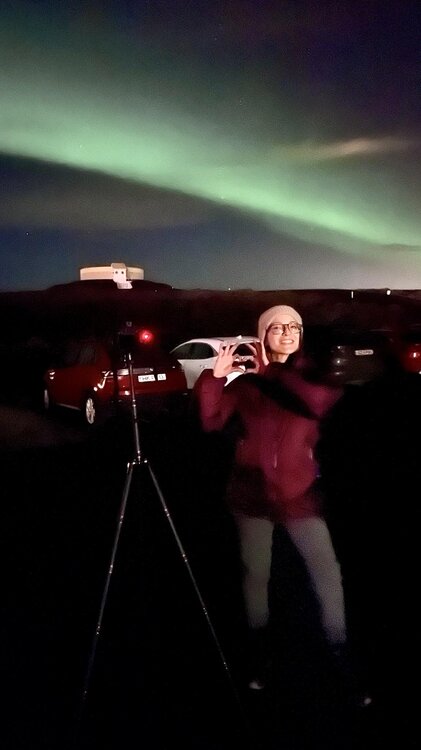
Interesting! Thanks as always for your fascinating insights. And oh I know what’s coming is brutal compared to our usual December cold (when we can get it), but I am truly very adapted to that kind of real cold weather. We just got back from a hiking trip to the north of Iceland last month and we spent days in ~25 degrees with 30-40mph polar winds, which Iceland is famous for. And I’ve been in -10/20 continental cold before; that’s *really* cold stuff. But it’s all about how you dress, and a lot of people aren’t accustomed to dressing properly for real cold conditions. You need layers on top of layers and good down or lofted synthetic insulation (preferably over a good mid weight fleece), along with something that blocks at least the wind when wind chill is a serious factor. Of course good cold weather outdoor gear is expensive and not everyone is able to go that route when we see that kind of cold so infrequently, but at the very least an inexpensive medium weight (at least) down jacket or parka is a good investment (Eddie Bauer surprisingly makes decent stuff at a relatively cheap price point). But if someone was in the market for a high quality insulation piece, Patagonia is great for everything (highly recommend their Better Sweater fleece, super warm), Arc’teryx for synthetic or shells, Rab or Montbell for down, etc. And Jottnar, an upstart British outdoor company, makes excellent stuff as well. I have a moisture resistant down jacket from them with excellent wind resistance. Edit: From our Iceland trip

-
What do you call it when you feel alive and refreshed in the cold and depressed and unhappy in unseasonable warmth? Should probably see a doctor about that . And my wife is the exact diametric opposite of me, so naturally we’re perfect for each other. Though she does enjoy the winter hiking we do, I have to keep her bundled up like a freshly hatched chicken.
-
My good GTX shell down parka is coming out for three days. Hoping it’s not the only time I need it this winter.
-
Nice chilly rain coming down by EWR. Really sets the Christmas mood . Some of the western M/A folks are reporting a nice thump of snow. Some have a couple inches already. Incredibly jelly.
-
Forky I’ll never forget your Jan 6th (I think?) call last year with the highly uncertain system. Lots of back in forth in the thread then you randomly popped in and quipped “enjoy the snow,” and snow it did. Think I got a very respectable 5-6 inches out of that. Bookended by 1/29 getting 16. Was a nice Jan for me.
-
It’s interesting because Dec was well set up minus the lack of snow; all that separated us from decent snowfall was trough placement being too far west. Likely without the insane NA SST’s we’d be celebrating an epic Dec and ready to write off the warm start to Jan, no? Just seems like Dec was more of a near miss considering all factors, but I certainly understand if the medium range prognostication is unfavorable. Really trying my best to retain some positivity. We’re due for some favorable luck to break our way for a change.