

TheClimateChanger
-
Posts
1,881 -
Joined
-
Last visited
Content Type
Profiles
Blogs
Forums
American Weather
Media Demo
Store
Gallery
Posts posted by TheClimateChanger
-
-
34 minutes ago, TimB said:
Year to date precip is currently in 2nd place behind 2018, which of course was the record year (but a large amount of that precip from 1/1 through early April fell as snow).
Very impressive. 4th warmest and 2nd wettest YTD in the threaded record, and winter season snowfall currently sitting at 6th least on record.
-
-
-
16 minutes ago, Itstrainingtime said:
You probably shouldn't think so much. Just enjoy the BN temps today.
")
Below normal? I wish. Not so here.
-
As we round out the first quarter of 2024, I thought it might be a good time for a review of temperatures. Through the first quarter of 2024, it's been quite toasty in central Pennsylvania.
Williamsport: Third warmest start to the year [of 130 years], behind 2012 & 2023.
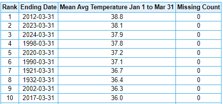
Harrisburg / Middletown: Sixth warmest start to the year [of 136 years], behind 2020, 2023, 1998, 2012 & 1990.
-
 1
1
-
-
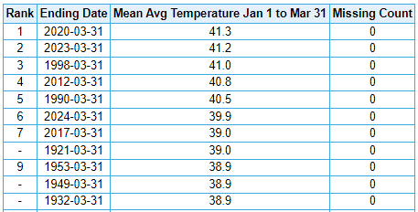
Not to change the subject from the potential severe weather, but a quick climate glance for the first quarter of 2024 [through 3/31].
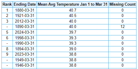
The average mean temperature for the first 1/4 of the year has been 39.7F, placing it in 5th place in the threaded record. Note, however, that 1890 [0.3F warmer] has 12 missing days, so it very well might be lower than this year if not for the missing data. Second warmest start to the year at the airport behind 2012. Last year had the 8th warmest first three months, now dropped back to 9th place in the threaded record.
-
Up to a sultry T/Td of 69/64 at Washington County Airport, as of the top of the hour. Could see 70s this afternoon.
-
2 hours ago, JetsPens87 said:
2 things here...
First is an absolute LOL at him still refusing to give up on BN temps
Second is...where is that for and how is March 2012 not first?
Also, not sure about "edged" out 2016. His favorite data source had this March a full 0.3C ahead of 2016: nsstc.uah.edu/data/msu/v6.0/tlt/uahncdc_lt_6.0.txt
-
1 hour ago, TimB said:
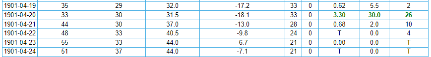
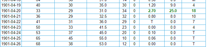
This is now the wettest April day ever observed at Pittsburgh international, with 1.62” and counting observed since 1am. The official all time record for any April day is 2.34” on 4/14/1922. We’re up to 6th on the all time list.
Wow, pretty crazy. April 1901 still takes the cake though.
2.05 inches of precipitation, and 12.7 inches of snow on April 3, 1901.

Later in the month, 1.53" of rain on the 19th and an additional 2.24" on the 20th.
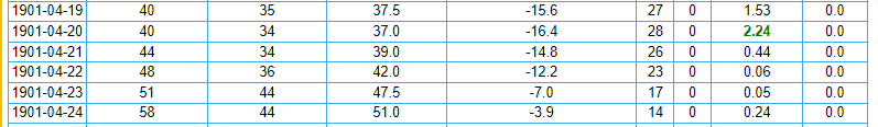
What a heartbreaker that must have been though for southwestern Pennsylvania, as parts of eastern Ohio saw up to 3 1/2 feet of snow. At least, the nearly 13" of snow earlier in the month would have provided some consolation.
Warren, Ohio
Gratiot, Ohio
-
-
Wow. Not sure I've ever seen it this high for our region.

-
-
3 minutes ago, Bubbler86 said:
Did Coyotes Joe's stay open for the 101 temp?
No idea what that is. But that heat was insane either way. It never even reached 99F or above there in the scorching summer of 1988. Altoona set an all-time high of 103F or 104F on that date too.
-
3 hours ago, Bubbler86 said:
Hershey. Sometimes heat closes down some rides.
https://www.abc27.com/hershey/hersheypark-rain-policy-weather/
I can believe it. I was at Cedar Point on July 21, 2011. It was 102F at Toledo Express Airport and 105F at Toledo Executive Airport that day. Absolutely brutal.
The next day reached 101F at DuBois - the first and only time [dating to 1963] that it has exceeded 98F there.
-
-
Let's hope this is wrong.

-
 1
1
-
 1
1
-
 1
1
-
-
Also, on the topic of snowfall. Currently sixth lowest seasonal total [since 1880-1881]. Last year's total was eighth least but may drop to ninth (as shown below) if there is no additional significant snowfall this year.
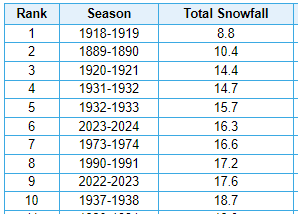
Limiting to snowfall records taken at one of the two airport sites (1935-1936 to present), makes it even worse.
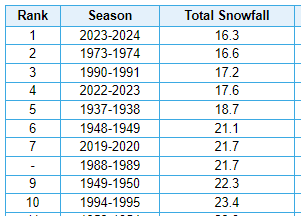
There had only been 3 years with less than 20" at either airport site (1937-1938, 1973-1974, and 1990-1991) and we are currently in danger of a second straight year with less than 20 inches. I blame @Burghblizz. He had noted we haven't had to deal with any 20" or less seasons shortly before the March 2018 storm were a lot of people were complaining about the lack of snowfall in recent winters. Of course, 2017-2018 had a crazy ending with 10.5" from the big storm and another 7.3" over the first few weeks of April. Now we've had two straight [likely], and just barely exceeded that total in 2019-2020.
-
When will be our first below normal month? Any guesses?
-
11 minutes ago, TheClimateChanger said:
Number of days with 1"+ snow cover at MFD [dating to early 1950s]:
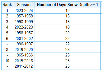
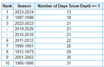
Similar story at CAK:
-
Just now, TheClimateChanger said:
It's high time the NWS amend the description of climate in Mansfield, Ohio. There is not near continuous snow cover from December through March anymore. That would be considered absurd today. There's barely been 20 inches the last two winters combined. And 3 of the top 10 least snowy winters are in the last 5 years.
I really believe Ohio is ground zero for climate change. Feels like it's warming faster in this region than anywhere on the planet.
Number of days with 1"+ snow cover at MFD [dating to early 1950s]:
-
It's high time the NWS amends the description of climate in Mansfield, Ohio. There is not near continuous snow cover from December through March anymore. And daytime temperatures regularly exceed freezing in the winter. That would be considered absurd today. There's barely been 20 inches the last two winters combined. And 3 of the top 10 least snowy winters are in the last 5 years.
I really believe Ohio is ground zero for climate change. Feels like it's warming faster in this region than anywhere on the planet.
-
 1
1
-
-
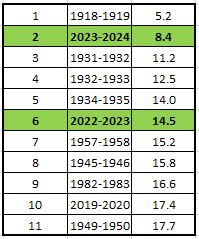
Canton-Akron (CAK)
Official records, since 1948:
Manually expanded dataset back to 1893, including snowfall records from other sites in the threaded record that aren't included in the official record for some reason:
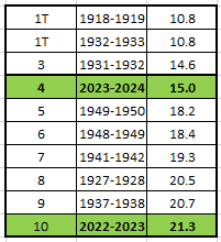
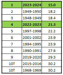
Mansfield, OH (MFD) - extended back to 1892-1893, excluding several years with no or significant missing data
-
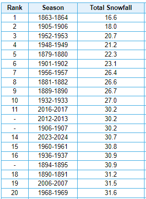
Some other snowfall futility notes. Currently, fourth least on record at Erie, PA. Note these values have been manually corrected by me. xMacis and the NWS CLE site [which uses the xMacis] has a bunch of random missing data mainly from the 1920s-1940s, where snowfall actually was observed.
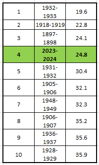
Looking at these values, it will be the first season with less than 40" since 1952-1953, and the first season with less than 30" since 1932-1933 [barring some late season magic]. In recent decades, the low to mid 40-inch range was the absolute minima at Erie Airport.
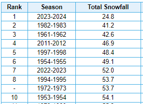
In fact, if we narrow the search to the most recent 71 winters [dating back to 1953-1954] at the airport site, it's UGLY. The least amount of snow observed in the 70 years from 1953-1954 to 2022-2023 was 41.2 inches in 1982-83. Last year's 52.0 inches was sixth least in that stretch. This winter is at 24.8 inches. Wow.
-
Here's Lansing, Michigan snowfall records [earlier years at East Lansing, Michigan], excluding a few years with excessive missing data:
Maybe a bit questionable that the very first year with data ranks as lowest. Looking at the monthly data, that looks mostly a function of the fact that precipitation was 25-50 percent of modern norms for the bulk of the cold season.
Central Pa. Spring 2024
in Upstate New York/Pennsylvania
Posted
Also [through yesterday], this has been the 4th wettest start to the year at Williamsport and 5th at Harrisburg. 2024 is certainly holding its own in the annals of weather history.