

Mount Joy Snowman
-
Posts
4,968 -
Joined
-
Last visited
Content Type
Profiles
Blogs
Forums
American Weather
Media Demo
Store
Gallery
Everything posted by Mount Joy Snowman
-

Central PA Winter 2024/2025
Mount Joy Snowman replied to Voyager's topic in Upstate New York/Pennsylvania
Yeah we were actually outside loading the kids so can confirm it was all snow but as you said, it’s already stopped ha. Feels like things are going to be pretty meager for us down here. -
Central PA Winter 2024/2025
Mount Joy Snowman replied to Voyager's topic in Upstate New York/Pennsylvania
Sitting at 33/18 as very stray minuscule flurries have broken out. Not expecting much down this way but I do think someone like @Voyager may do okay today. -
Central PA Winter 2024/2025
Mount Joy Snowman replied to Voyager's topic in Upstate New York/Pennsylvania
Low of 24. Been out of the loop a bit the last 24 hours but it seems we’re losing our Tuesday storm to those damn southerners again? Needing a north shift inside of 84 hours isn’t the worst spot to be in so I’ll hold out hope for at least a few inches. In the meantime, let’s see if we can snag a little over performer today. I wouldn’t mind seeing some sleet pile up. -
Central PA Winter 2024/2025
Mount Joy Snowman replied to Voyager's topic in Upstate New York/Pennsylvania
Whereas the GFS keeps the bigger totals to the south of us, the CMC presents mixing issues for those areas and keeps their totals more meager, while spitting out like 3-6" for most of our area. -
Central PA Winter 2024/2025
Mount Joy Snowman replied to Voyager's topic in Upstate New York/Pennsylvania
I mean, I actually do like where we sit haha, especially with how some of the other models are depicting things. It may work out, it may not, but I'll take that positioning any day of the week. -
Central PA Winter 2024/2025
Mount Joy Snowman replied to Voyager's topic in Upstate New York/Pennsylvania
I've seen enough, official MJS forecast for storm #1 for the Lancaster area: A couple hour period of snow during the mid to late afternoon hours totals about a half inch, followed by a long duration sleet event of varying intensity that amounts to an additional half inch of IP, and ending as a period of light freezing rain and drizzle that adds .05-.1" of glaze on top of everything. All finished up long before the predawn hours, leaving us with a nice inch plus winter cake that should be dense enough to hang around through the day and give us a white-ish Superbowl Sunday evening. Book it. -
Central PA Winter 2024/2025
Mount Joy Snowman replied to Voyager's topic in Upstate New York/Pennsylvania
The NAM continues to advertise a nice couple hour period of moderate snow Saturday afternoon (more so for us easterners) before changing to sleet Saturday evening. -
Central PA Winter 2024/2025
Mount Joy Snowman replied to Voyager's topic in Upstate New York/Pennsylvania
Low of 34 here, and as I mentioned last night, my total qpf came to .49" off of my .2" IP/ZR. I feel real good about Tuesday and real uneasy beyond that. I actually really like Saturday night too as a fun sneaky little event with more upside than yesterday's affair. To say I'll be locked into today's 12z runs is an understatement ha. I am not in favor of separate threads for each threat and haven't had any issues deciphering which posts are about which threat. Just one man's thoughts. National high of 97 at Rio Grande Village, TX and low of -28 near Poplar, MT for an impressive Lower 48 diurnal range of 125 degrees. Happy Friday, all! NAM is running so dare I say, in my best Kevin James voice........gentlemen, start your engines!!! -
Central PA Winter 2024/2025
Mount Joy Snowman replied to Voyager's topic in Upstate New York/Pennsylvania
My .2” of sleet and ice accretion melted down to .49” liquid. You can all rest easy now. -
Central PA Winter 2024/2025
Mount Joy Snowman replied to Voyager's topic in Upstate New York/Pennsylvania
Yeah probably shouldn't have said shocked, as I’ve always touted the strength of CAD and how it gets under-modeled. Still, thought we’d at least get to upper 30s or 40, especially down my way, and that didn’t even happen. Even when you know its tendencies, CAD can still surprise ha. -
Central PA Winter 2024/2025
Mount Joy Snowman replied to Voyager's topic in Upstate New York/Pennsylvania
I’m still trying to fully figure out our new spot over here on the east end of West Hempfield Township. I’m equidistance from Mount Joy and Lancaster (about 5 miles to each as the crow flies). I also have a wee bit elevation on my side now, as we’re kind of on the northern base of a ridge line. -
Central PA Winter 2024/2025
Mount Joy Snowman replied to Voyager's topic in Upstate New York/Pennsylvania
Lock it the F in! -
Central PA Winter 2024/2025
Mount Joy Snowman replied to Voyager's topic in Upstate New York/Pennsylvania
I am shocked by how much we've been locked in the cold over here. Been stuck around 35 all afternoon. I owe @canderson an apology for guaranteeing a full melt-off ha. -
Central PA Winter 2024/2025
Mount Joy Snowman replied to Voyager's topic in Upstate New York/Pennsylvania
This is pretty bullish for WPC......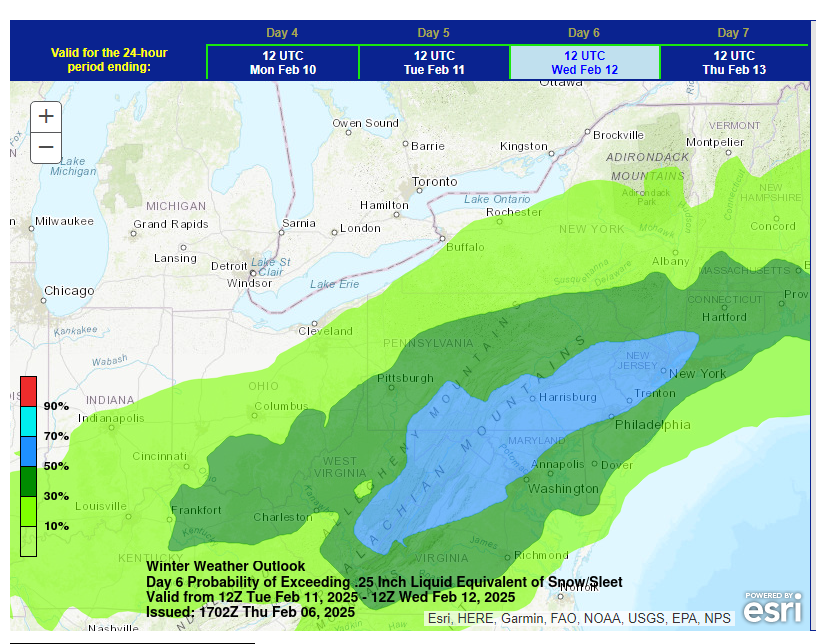
-
Central PA Winter 2024/2025
Mount Joy Snowman replied to Voyager's topic in Upstate New York/Pennsylvania
Ukie on board for Tuesday as well. We may get damn near full agreement on the 12z suite. Paging Euro..... -
Central PA Winter 2024/2025
Mount Joy Snowman replied to Voyager's topic in Upstate New York/Pennsylvania
In terms of just sheer activity, this seven day period from this Saturday through next Saturday should be mega memorable. -
Central PA Winter 2024/2025
Mount Joy Snowman replied to Voyager's topic in Upstate New York/Pennsylvania
Canadian looks like it will answer the bell as well. -
Central PA Winter 2024/2025
Mount Joy Snowman replied to Voyager's topic in Upstate New York/Pennsylvania
Still a LOT to finesse five days out but a great start to 12z. -
Central PA Winter 2024/2025
Mount Joy Snowman replied to Voyager's topic in Upstate New York/Pennsylvania
GFS is an absolute stunner. My pants are tightening by the minute. -
Central PA Winter 2024/2025
Mount Joy Snowman replied to Voyager's topic in Upstate New York/Pennsylvania
Yeah I was worried at first but it played out just fine. Would work well for most everyone. -
Central PA Winter 2024/2025
Mount Joy Snowman replied to Voyager's topic in Upstate New York/Pennsylvania
It will melt just fine. Things already softening up. -
Central PA Winter 2024/2025
Mount Joy Snowman replied to Voyager's topic in Upstate New York/Pennsylvania
Some moderate ZR passing through here now but expect the transition to plain rain imminently as the temp is sitting right at 32 and creeping upwards. -
Central PA Winter 2024/2025
Mount Joy Snowman replied to Voyager's topic in Upstate New York/Pennsylvania
Were any of my southern friends awake during the overnight hours to see if we had a brief period of snow to start things off or was it straight sleet from the get-go? As of now, I'm leaning towards just putting IP/ZR as my precip types in my spreadsheet, with the caveat that some plain rain is yet to come. -
Central PA Winter 2024/2025
Mount Joy Snowman replied to Voyager's topic in Upstate New York/Pennsylvania
Only about a tenth of an inch of combined sleet and ice out there but it's enough to have everything caked. Schools have closed. A bit underwhelming but we have a more potent batch approaching the area, likely as freezing rain. We'll see what that does as the temp hovers at 31. Glad to hear next week's event is still showing up nicely. -
Central PA Winter 2024/2025
Mount Joy Snowman replied to Voyager's topic in Upstate New York/Pennsylvania
I do. I root for maximum winter, in all its forms, at all times. Yes, I'm a psycho haha.


