Mount Joy Snowman
-
Posts
4,958 -
Joined
-
Last visited
Content Type
Profiles
Blogs
Forums
American Weather
Media Demo
Store
Gallery
Everything posted by Mount Joy Snowman
-

Central PA Winter 2024/2025
Mount Joy Snowman replied to Voyager's topic in Upstate New York/Pennsylvania
A big ‘ol Trace of rain yesterday and 34 when I left the house this morning but hit 27 on car therm through the rurals. -
Central PA Winter 2024/2025
Mount Joy Snowman replied to Voyager's topic in Upstate New York/Pennsylvania
Yes, that’s him! Thank you Blizz! I only lurked there, didn’t post. I think he had a Rockville address and lived up on Blue Mountain with decent elevation (~1,000’). Man that’s a trip down memory lane. I’m just glad someone could finally confirm my half-baked recollections ha. -
Central PA Winter 2024/2025
Mount Joy Snowman replied to Voyager's topic in Upstate New York/Pennsylvania
Yes, and I am still looking for someone to confirm the existence of a poster named UndertakersSon (went by UTS) from some far-flung weather board from many moons ago -
Central PA Winter 2024/2025
Mount Joy Snowman replied to Voyager's topic in Upstate New York/Pennsylvania
Some of you may be wondering if we can complete the winter sweep, with Dec Jan and Feb all coming in below normal? With that in mind, I got out the MJS crystal ball and it says, yes indeed we will pull off the trifecta, but not by much. The final average monthly temp for February will come in at 32.6, good for almost a one-degree BN departure and middle of the pack all-time. Book it. Now back to your regularly scheduled programming. -
Central PA Winter 2024/2025
Mount Joy Snowman replied to Voyager's topic in Upstate New York/Pennsylvania
Glad to hear sledding was good. Sounds like a rock-solid base up there. As for tracking, yeah things become even that much more thread-the-needle-ish as we move towards the equinox. We'll need things to line up just right but I see some signs of a possible board pleaser at some point. Wouldn't say the odds are great ha, but they aren't extinguished either. -
Central PA Winter 2024/2025
Mount Joy Snowman replied to Voyager's topic in Upstate New York/Pennsylvania
Low of 26. Pretty nice week ahead. Seems likely we'll have some storm chances of varying type through mid-March. -
Central PA Winter 2024/2025
Mount Joy Snowman replied to Voyager's topic in Upstate New York/Pennsylvania
If true, that’s unfortunate. Got to be able to laugh at oneself. -
Central PA Winter 2024/2025
Mount Joy Snowman replied to Voyager's topic in Upstate New York/Pennsylvania
Low of 18. Solid seasonable weekend on tap. -
Central PA Winter 2024/2025
Mount Joy Snowman replied to Voyager's topic in Upstate New York/Pennsylvania
Forgot to formally mention that I had .1” of snow yesterday off of .01” liquid. Exhilarating stuff, I know. -
Central PA Winter 2024/2025
Mount Joy Snowman replied to Voyager's topic in Upstate New York/Pennsylvania
Low of 22. Decent transition weekend on tap. Happy Friday, all. -
Central PA Winter 2024/2025
Mount Joy Snowman replied to Voyager's topic in Upstate New York/Pennsylvania
It's been a day of constant on and off snow showers. The last hour a couple of heavier bands rolled through, one of which created whiteout conditions. Definitely .1" going in the books, with the potential for more depending on how the rest of the afternoon plays out. This 500 closed low passage has made for a fun little day. -
Central PA Winter 2024/2025
Mount Joy Snowman replied to Voyager's topic in Upstate New York/Pennsylvania
Heck yeah, have fun pal. My buddy's cabin is looking great. You guys are probably even better yet. -
Central PA Winter 2024/2025
Mount Joy Snowman replied to Voyager's topic in Upstate New York/Pennsylvania
It's a flizzard here and I'll say it again, for the 97th time this season, yet another day that looks and feels like winter. -
Central PA Winter 2024/2025
Mount Joy Snowman replied to Voyager's topic in Upstate New York/Pennsylvania
Low of 12. Looks like most of us should see some flakes flying through the air today. Someone could win out to the tune of an inch. Likely westerners. We shall see. -
Central PA Winter 2024/2025
Mount Joy Snowman replied to Voyager's topic in Upstate New York/Pennsylvania
Haha that's amazing! I wonder who it thinks the bikini-clad beer-drinking girl is? We need her to come around more -
Central PA Winter 2024/2025
Mount Joy Snowman replied to Voyager's topic in Upstate New York/Pennsylvania
None! Clearfield is the county seat of Clearfield Co. One of the great things about memorizing county seats is that so many of them have them same name as the county itself haha. -
Central PA Winter 2024/2025
Mount Joy Snowman replied to Voyager's topic in Upstate New York/Pennsylvania
It's so funny you said this. I was just about to post how MY big claim to fame is being able to fill in all 67 PA counties on a blank map haha. The guys at work didn't believe me and printed out a blank PA map for me to complete right on the spot and I scored a 100. It hangs on my desk wall to this day. I used to know all the county seats too. Now, I'd probably miss a few. So yeah, add me to the list of geography freaks ha. We are a screwed-up bunch. -
Central PA Winter 2024/2025
Mount Joy Snowman replied to Voyager's topic in Upstate New York/Pennsylvania
Here's a new one, Antelope Creek, ND came in with the national low of -45. Who doesn't love Antelope Creek. MDT had an impressive -13 degree departure yesterday. -
Central PA Winter 2024/2025
Mount Joy Snowman replied to Voyager's topic in Upstate New York/Pennsylvania
Low of 13. -
Central PA Winter 2024/2025
Mount Joy Snowman replied to Voyager's topic in Upstate New York/Pennsylvania
16 when I left the house, which was the low. Stunning sunrise this morning. -
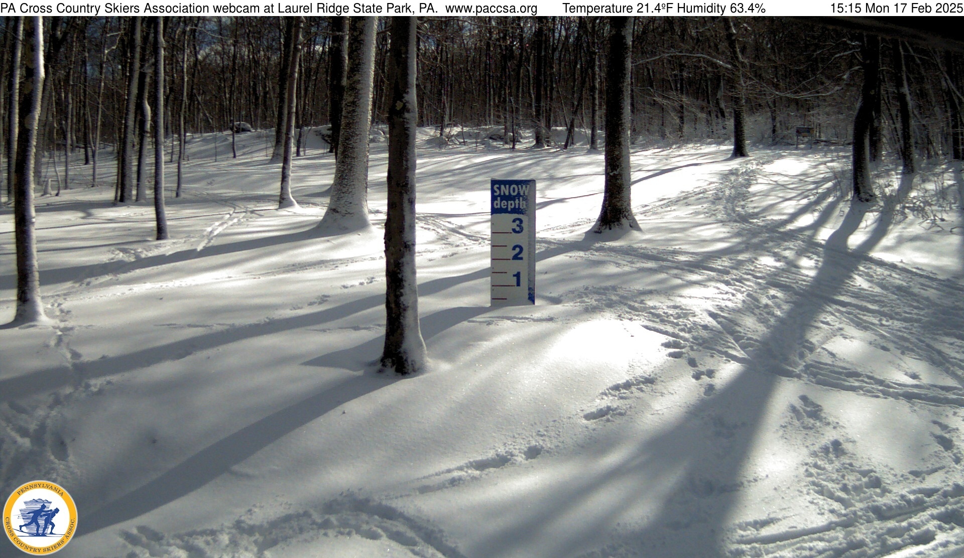
Central PA Winter 2024/2025
Mount Joy Snowman replied to Voyager's topic in Upstate New York/Pennsylvania
Laurels look beautiful…
-
Central PA Winter 2024/2025
Mount Joy Snowman replied to Voyager's topic in Upstate New York/Pennsylvania
Wouldn't that be something haha. But no, he didn't strike me as the type to have a message board account, but ya never know! -
Central PA Winter 2024/2025
Mount Joy Snowman replied to Voyager's topic in Upstate New York/Pennsylvania
WARNING: This will be a long post but given the mood of the board lately, I wanted to tell a little story that I hope you'll find as joyful and rewarding as I did experiencing it. So, our neighborhood has an old guy who walks the neighborhood every day, many times a day, without fail. He's the type of guy who knows everyone's kids, carries treats in his pockets for all the dogs, and gives his little two finger wave to everyone he sees. His name is Carl and it's impossible to not, at the very least, know of him. If there were a vote for neighborhood president Carl would win in a landslide. We are relatively new to the development so I've only ever talked to Carl maybe 5-10 times and never really in-depth. Well, yesterday I was out checking the mail in the cold rain and Carl comes walking by, because of course he does, that's what Carl does, no matter the weather. I shout out to him, "Hey Carl, how about those winds coming?" That simple comment led to Carl coming over and talking to me about the weather for a good 15-20 minutes. Turns out he is a complete weather nut like us. I had no idea. He told me about all the old meteorologists and professors he loved to follow, most of whom I'd never heard of ha. He had also been a big Bastardi guy for decades and was talking about how he just watched some video of him talking about the upcoming storm potential. I quickly realized Carl was the real deal; he was one of us. He went on and on about all the models by name and mentioned the SER, PNA, NAO, MJO, and any other weather acronym you could think of. He knew them all. We bonded over the fact that we both had rain gauges and weather stations and kept detailed records of our precipitation going back decades, his much longer than mine of course. We talked about how our wives thought we were crazy but also how they constantly needed us for weather advice. The more we talked the more his eyes lit up. You could feel his sense of pure joy at having someone else to talk to who loved weather as much as him. It was palpable. We talked and talked and talked. He thought the midweek storm was going to pull back west a bit and I told him I thought it would stay suppressed to our southeast, both of us giving a nod to the fact that in the end we had no clue where it would end up haha. Weather led to other talk. "Oh, you studied Statistics at Penn State? I always had a bit of trouble with that when I was at Wharton." Turns out he was a Penn guy. "Oh, you tutored Stat too? I always had a penchant for teaching others." On and on we went, both of us just standing there in the cold rain and with no intention of the conversation ending. He told me of some neighborhood gossip as only Carl can and then ended by saying something to the effect of, "You know, weather is what it's all about. There's nothing greater, nothing more powerful or unpredictable. It has an effect on everything we do and affects our most important moments. Everything from D-Day to sporting events to weddings and funerals. Most importantly, it humbles us." Finally, he smiled before giving an obligatory nod and saying "alright then" as he waved and walked away. His gate was that of an old man. You know the type, wobbling back'n'forth, probably from one too many injuries over the years or a replaced hip or maybe just too many miles. It was the type of gate that just keeps on going, until one day it doesn't. I hope to see a lot more of Carl in the future, lord knows he'll be around, and around, and around. Moral of the story is this: talk to your neighbors, find yourself a Carl. You'll be better for it. I promise. And who knows, you may just find someone else who enjoys this crazy hobby as much as you do. It hit me yesterday that weather means a lot more than just tracking storms or being angry when we miss out; it's what binds all of us. I'm glad I got to meet the real Carl, and I think he was too. -
Central PA Winter 2024/2025
Mount Joy Snowman replied to Voyager's topic in Upstate New York/Pennsylvania
Low of 27 with .37” of rain and lots of wind. This week is a big letdown for sure but as some others have mentioned it’s hard to call it a total bust when the models started honing in on the correct solution five days out — the very time period at which we are told to start paying real attention. I wish they were better from range too but they’re all we’ve got ha. Who knows, maybe the AI infusion will improve things. Glad to hear some westerners are getting in on the fun. Some of those streamers look great. Onward. -
Central PA Winter 2024/2025
Mount Joy Snowman replied to Voyager's topic in Upstate New York/Pennsylvania
Yep. Monday afternoon has always been my breaking point. Just need to see a little movement back towards us by then. If not, well, we’ll chalk it up as another in a long line of misses 5-7 days out.