

Mount Joy Snowman
-
Posts
4,978 -
Joined
-
Last visited
Content Type
Profiles
Blogs
Forums
American Weather
Media Demo
Store
Gallery
Everything posted by Mount Joy Snowman
-

Central PA Winter 25/26 Discussion and Obs
Mount Joy Snowman replied to MAG5035's topic in Upstate New York/Pennsylvania
The HRRR paints a very solid picture, with a widespread 3-6" across our area by the end of its run at 7pm Sunday just as the coastal is ramping up. Next 12 hours would be fun to view. On to the NAM. -
Central PA Winter 25/26 Discussion and Obs
Mount Joy Snowman replied to MAG5035's topic in Upstate New York/Pennsylvania
0z HRRR with a much better depiction through the early part of its run. -
Central PA Winter 25/26 Discussion and Obs
Mount Joy Snowman replied to MAG5035's topic in Upstate New York/Pennsylvania
It's a totally fair concern. I would add that mixing issues through the first part of the storm have showed up on a number of models. The surface temps are marginal and really don't crash until the coastal gets ramping, so the question becomes how much qpf do we lose on the front end to mix or an inability to efficiently accumulate on surfaces. All valid concerns. Bottom line, as you said, be prepared for anything. Isn't that what makes this all fun anyway? Cheers! -
Central PA Winter 25/26 Discussion and Obs
Mount Joy Snowman replied to MAG5035's topic in Upstate New York/Pennsylvania
Man what a score this would be for the GFS. -
Central PA Winter 25/26 Discussion and Obs
Mount Joy Snowman replied to MAG5035's topic in Upstate New York/Pennsylvania
Yes it got real foggy real quick, even before sundown. I assume a warm air advection fog moving over the cold wet ground and remains of the snowpack? -
Central PA Winter 25/26 Discussion and Obs
Mount Joy Snowman replied to MAG5035's topic in Upstate New York/Pennsylvania
Alright boys, what's the skinny? Grandma came over to watch the kids and the wife and I went out for lunch and some drinks. Even played some backgammon at the bar haha. Anyone partake? I've been teaching my wife. Things still ticking west? I'm going to dial in for 0z. -
Central PA Winter 25/26 Discussion and Obs
Mount Joy Snowman replied to MAG5035's topic in Upstate New York/Pennsylvania
Yeah, AI was a good bit juicer with the qpf. -
Central PA Winter 25/26 Discussion and Obs
Mount Joy Snowman replied to MAG5035's topic in Upstate New York/Pennsylvania
It seems like southcentral Jersey is going to be the place to be for this bad boy. I have a friend who lives in Hammonton, NJ and feel like that could be ground zero. A general 4-6" for our forum would be a nice event with some boom potential for those of us in eastern areas like Lancaster. -
Central PA Winter 25/26 Discussion and Obs
Mount Joy Snowman replied to MAG5035's topic in Upstate New York/Pennsylvania
GFS a bit weaker and a touch southeast with the best banding but still okay for the forum. A compromise solution seems to be emerging. -
Central PA Winter 25/26 Discussion and Obs
Mount Joy Snowman replied to MAG5035's topic in Upstate New York/Pennsylvania
I was going to say a bit more of a hybrid. Certainly not a traditional Miller B in the way that we think of it around these parts but you may be right technically. I'm not entirely clear on the exact criteria for categorizing such things. -
Central PA Winter 25/26 Discussion and Obs
Mount Joy Snowman replied to MAG5035's topic in Upstate New York/Pennsylvania
FWIW, the FV3 at range also spits out a preferred coastal track. -
Central PA Winter 25/26 Discussion and Obs
Mount Joy Snowman replied to MAG5035's topic in Upstate New York/Pennsylvania
BIG changes.....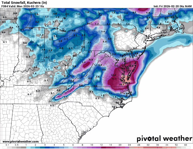
-
Central PA Winter 25/26 Discussion and Obs
Mount Joy Snowman replied to MAG5035's topic in Upstate New York/Pennsylvania
NAM a MUCH better result for the forum. Great start to 12z. -
Central PA Winter 25/26 Discussion and Obs
Mount Joy Snowman replied to MAG5035's topic in Upstate New York/Pennsylvania
Low of 34 with .71” of rain and one hell of a swampy backyard. I’m off today so I plan on being pretty dialed in for the 12z runs. The kids may have something to say about that but that’s the plan ha. -
Central PA Winter 25/26 Discussion and Obs
Mount Joy Snowman replied to MAG5035's topic in Upstate New York/Pennsylvania
Post of the year right here. Shut it all down. Amazing work pal. -
Central PA Winter 25/26 Discussion and Obs
Mount Joy Snowman replied to MAG5035's topic in Upstate New York/Pennsylvania
Yes I saw that. All I know is, like you, I got zero at my house in Farmdale and was stunned by what transpired. -
Central PA Winter 25/26 Discussion and Obs
Mount Joy Snowman replied to MAG5035's topic in Upstate New York/Pennsylvania
Okay, yes that's the timeframe I was thinking of too. I was thinking that event was more isolated than what you described but I guess I am thinking of the area that got a foot, which I believe was a narrow swath right over the heart of Manheim Township, which is where Horst resides. Yeah, I would love to find that article again. The LNP search engine is doing me no favors ha. -
Central PA Winter 25/26 Discussion and Obs
Mount Joy Snowman replied to MAG5035's topic in Upstate New York/Pennsylvania
Are you referring to that overnight event that dumped like a foot in primarily the Lititiz/Manheim Township area? That was crazy but I thought it was considered more of an unexplainable random convective event similar to a stray pop-up thunderstorm. I thought they were having trouble determining the reasoning for the event, almost freakish in nature. I didn't think it was associated with a norlun but I could be mistaken. Perhaps we are talking about different events? There used to be a really good LNP article talking about that exact event but I can't find it despite searching their website to the best of my ability. Do you recall the date or even the year of the one you're talking about? I do recall that photo of Horst with his foot of snow haha. -
Central PA Winter 25/26 Discussion and Obs
Mount Joy Snowman replied to MAG5035's topic in Upstate New York/Pennsylvania
Virtually no support for the ultra-tucked solution we saw on the 12z GFS. -
Central PA Winter 25/26 Discussion and Obs
Mount Joy Snowman replied to MAG5035's topic in Upstate New York/Pennsylvania
I still thought there were some notable improvements on the Euro, albeit slight. I agree that an advisory type event is most likely at this point, perhaps low-end warning. -
Central PA Winter 25/26 Discussion and Obs
Mount Joy Snowman replied to MAG5035's topic in Upstate New York/Pennsylvania
Probably true but in her mind the next man to come along is always Mr. Perfect. -
Central PA Winter 25/26 Discussion and Obs
Mount Joy Snowman replied to MAG5035's topic in Upstate New York/Pennsylvania
Is she on to something or will she be left at the alter?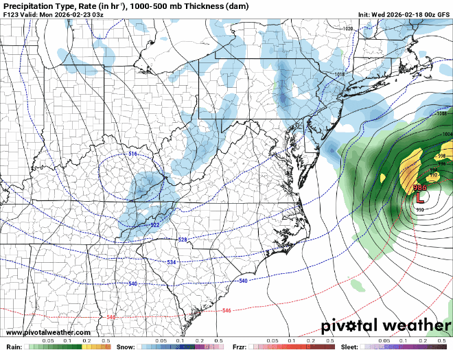
-
Central PA Winter 25/26 Discussion and Obs
Mount Joy Snowman replied to MAG5035's topic in Upstate New York/Pennsylvania
GFS will not relent. Throws out monster and ticks west. -
Central PA Winter 25/26 Discussion and Obs
Mount Joy Snowman replied to MAG5035's topic in Upstate New York/Pennsylvania
Low of 33 and foggy but with no rain yet. The overnight runs were a mixed bag but more bad than good. My fear, and most likely outcome at this point, is that we are too far west to cash in on the best of the coastal and too far east for the best of the upper level trough action. Stuck somewhere in the middle with a showery couple, to perhaps a few, inches. Next 36 hours critical for any hope with the coastal. 12z looms. -
Central PA Winter 25/26 Discussion and Obs
Mount Joy Snowman replied to MAG5035's topic in Upstate New York/Pennsylvania
Yep, and so did the Canadian. Lord knows we are in that period where the models love to seesaw. Fun times ahead.


