Mount Joy Snowman
-
Posts
4,964 -
Joined
-
Last visited
Content Type
Profiles
Blogs
Forums
American Weather
Media Demo
Store
Gallery
Everything posted by Mount Joy Snowman
-

Central PA Spring 2023
Mount Joy Snowman replied to Itstrainingtime's topic in Upstate New York/Pennsylvania
If the 12z HRRR is to be believed, it clears out a bit over the next few hours and through the midday but then starts to build back in late this afternoon through the evening. Then it gradually thins out through Friday and mostly clears up as we head towards the weekend, with some lingering but less dense plumes hanging around in western PA and Ohio. Developing.... -
Central PA Spring 2023
Mount Joy Snowman replied to Itstrainingtime's topic in Upstate New York/Pennsylvania
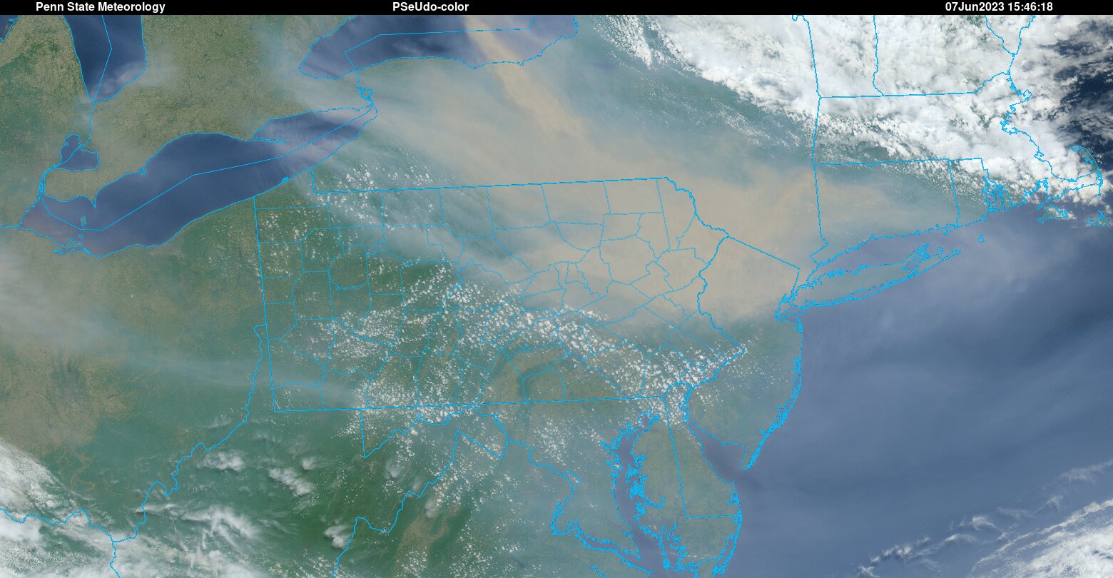
Good morning all, low of 47 here. Man, is the smoke thick out there right now. It looks like it should ease up a bit throughout the midday before building back in this evening, and then slowly thinning out tomorrow and through the weekend. But who really knows, as this stuff seems tough to predict as far as exact location and timing. Outside chance of some rain showers later today but the better chance for our area is late in the day tomorrow. Confidence building for a more soaking rainfall Monday into Tuesday and then hopefully some more opportunities in the extended period. Let's get this smoke the hell out of here! -
Central PA Spring 2023
Mount Joy Snowman replied to Itstrainingtime's topic in Upstate New York/Pennsylvania
Just saw that exact tweet. Surreal. Here it is.... -
Central PA Spring 2023
Mount Joy Snowman replied to Itstrainingtime's topic in Upstate New York/Pennsylvania
Oh it is. It's rotating southeast pretty swiftly. This evening will be "interesting" around here. -
Central PA Spring 2023
Mount Joy Snowman replied to Itstrainingtime's topic in Upstate New York/Pennsylvania
Northeastern PA in the thick of it right now. #ItsComing
-
Central PA Spring 2023
Mount Joy Snowman replied to Itstrainingtime's topic in Upstate New York/Pennsylvania
Crazy. What site are you using for that data? Thanks in advance. -
Central PA Spring 2023
Mount Joy Snowman replied to Itstrainingtime's topic in Upstate New York/Pennsylvania
Fact check: True. However, we are the Alps when compared to the piedmont to our southeast. -
Central PA Spring 2023
Mount Joy Snowman replied to Itstrainingtime's topic in Upstate New York/Pennsylvania
Yep. Using the 'ol Peakbagger website were ya? That's one of my faves. Glad to see you studying those Lancaster County relief maps. We also have some higher terrain across the eastern part of the county near Welsh Mountain, much of the southern hills in Solanco school district, and the infamous Chickies Ridge near me and @Itstrainingtime But as you mentioned, the highest point is up in the Furnace Hills near where Lancaster, Berks, and Lebanon Counties all meet. If you knew how much time I've spent looking at terrain maps over the years you'd have me committed haha. What can I say, we all have our "thing". -
Central PA Spring 2023
Mount Joy Snowman replied to Itstrainingtime's topic in Upstate New York/Pennsylvania
This reminds me of an ex's father who used to always say "Chickies will break that up" about every storm that ever approached, as if Chickie hill is some massive mountain that looms over everything and disrupts all storm patterns haha. -
Central PA Spring 2023
Mount Joy Snowman replied to Itstrainingtime's topic in Upstate New York/Pennsylvania
Low of 51. Very curious to see how bad the smoke gets later this afternoon and evening. This is certainly an anomalous event for us. -
Central PA Spring 2023
Mount Joy Snowman replied to Itstrainingtime's topic in Upstate New York/Pennsylvania
Sheesh take that and run. We got .01” here, maybe. -
Central PA Spring 2023
Mount Joy Snowman replied to Itstrainingtime's topic in Upstate New York/Pennsylvania
A solid little downpour, gusty winds, and a few stout rumbles up here in Harrisburg. Looks like we are getting screwed back at home yet again. -
Central PA Spring 2023
Mount Joy Snowman replied to Itstrainingtime's topic in Upstate New York/Pennsylvania
What a great page topper! -
Central PA Spring 2023
Mount Joy Snowman replied to Itstrainingtime's topic in Upstate New York/Pennsylvania
It looks like most of the Meso's are on board with at least some level of storm activity this afternoon, albeit fairly spotty, with the 3km NAM being the most vigorous. @TheClimateChanger wasn't messing around with his smoke warnings for tomorrow. Check out the latest near-surface plume forecast for tomorrow evening on the 12z HRRR. Not great Bob, not great at all. Keep those windows closed tomorrow night. -
Central PA Spring 2023
Mount Joy Snowman replied to Itstrainingtime's topic in Upstate New York/Pennsylvania
Low of 53 at my house. Man, @canderson wasn't kidding about the damage in Harrisburg from that hail storm this past weekend. On my walk through the capital complex this morning there were tons of limbs and leaves down everywhere. Keeping fingers crossed for someone to get lucky with some storms this afternoon. -
Central PA Spring 2023
Mount Joy Snowman replied to Itstrainingtime's topic in Upstate New York/Pennsylvania
Mornin' weather freaks. I bottomed out at a crisp 48 last night. Also added .03" of liquid gold on Saturday to go with my .01" from Friday. Hey, it's the small victories. Another beautiful week on tap but not much in the way of rain. Rinse and repeat. -
Central PA Spring 2023
Mount Joy Snowman replied to Itstrainingtime's topic in Upstate New York/Pennsylvania
Maybe I missed it but I didn’t realize that Harrisburg actually tied its record high for yesterday at 96. Damn. -
Central PA Spring 2023
Mount Joy Snowman replied to Itstrainingtime's topic in Upstate New York/Pennsylvania
It sure did. I got nothing additional, finished with a total of .01”. If you would have went off of just the pretty radar colors being put out yesterday by the Dover radar you’d have thought I had a half inch plus. Very disappointing. -
Central PA Spring 2023
Mount Joy Snowman replied to Itstrainingtime's topic in Upstate New York/Pennsylvania
I can confirm actual rain fell from the sky in batch one, to the tune of .01”, perhaps .015” ha. First rainfall measurement from the new acurite station! Next batch looks more potent. We shall see. -
Central PA Spring 2023
Mount Joy Snowman replied to Itstrainingtime's topic in Upstate New York/Pennsylvania
Was just looking at that. There is another mini cluster out ahead of that more potent batch that is about to go right over me as well. Will keep yinz posted. -
Central PA Spring 2023
Mount Joy Snowman replied to Itstrainingtime's topic in Upstate New York/Pennsylvania
That cluster of showers went right over me earlier and I can confirm it only laid down a trace. -
Central PA Spring 2023
Mount Joy Snowman replied to Itstrainingtime's topic in Upstate New York/Pennsylvania
Well that prior post clearly did not go through as intended haha. Let’s try this again….. -
Central PA Spring 2023
Mount Joy Snowman replied to Itstrainingtime's topic in Upstate New York/Pennsylvania
<blockquote class="twitter-tweet"><p lang="en" dir="ltr">Not a single SPC storm report during the month of May in the entirety of Pennsylvania! This is the first time no May reports have been submitted in PA to SPC since 2000 when monthly/annual stats have been tabulated by the organization. <a href="https://twitter.com/hashtag/pawx?src=hash&ref_src=twsrc%5Etfw">#pawx</a> <a href="https://t.co/d3c288kKoC">pic.twitter.com/d3c288kKoC</a></p>— PA Climate Office (@PAClimateOffice) <a href="https://twitter.com/PAClimateOffice/status/1664254571034689536?ref_src=twsrc%5Etfw">June 1, 2023</a></blockquote> <script async src="https://platform.twitter.com/widgets.js" charset="utf-8"></script> -
Central PA Spring 2023
Mount Joy Snowman replied to Itstrainingtime's topic in Upstate New York/Pennsylvania
Low of 51. Gorgeous day on tap. My driest month ever at .37" is officially in the books. -
Central PA Spring 2023
Mount Joy Snowman replied to Itstrainingtime's topic in Upstate New York/Pennsylvania
That is shocking but as Bubbler mentioned there has been quite the east/west component to the cool air lately. I saw a lot of places in Chester County yesterday topped out in the low 70s, whereas I hit 83. I did notice there was the normal elevation-dependent nature with the inversion last night, with the top of the ridge being a good ten degrees warmer than some of the low-lying rural spots. Obviously that doesn't factor in with you and I being at similar elevations, but yeah that east/west component must have really been something.