Mount Joy Snowman
-
Posts
4,966 -
Joined
-
Last visited
Content Type
Profiles
Blogs
Forums
American Weather
Media Demo
Store
Gallery
Everything posted by Mount Joy Snowman
-

Central PA Summer 2023
Mount Joy Snowman replied to canderson's topic in Upstate New York/Pennsylvania
The humidity is ungodly today. My DP is 73 and I'm currently surrounded by storms. -
Central PA Summer 2023
Mount Joy Snowman replied to canderson's topic in Upstate New York/Pennsylvania
Haha, if only. I don't play lottery, of any type. What can I say, my stats brain just won't let me ha. -
Central PA Summer 2023
Mount Joy Snowman replied to canderson's topic in Upstate New York/Pennsylvania
Good morning my fine friends of American Weather. If it please the members, I'm going to take a moment to briefly toot my own horn. 10 days ago, I predicted June would end with an average temp of 70.3 at MDT, and well, June ended with an average temp of 70.3. Yes, I know there were only five days left in the month at that point but it still takes some gusto to nail the daily averages to that degree, and yes, a good bit of luck is required as well ha. But congrats to me! And thank you all for indulging in my numbers-based hubris National high/low of 116 at Stovepipe Wells, CA and 29 near Big Piney, WY. Carry on. -
Central PA Summer 2023
Mount Joy Snowman replied to canderson's topic in Upstate New York/Pennsylvania
So who all felt the massive propane explosion at the Rapho Township Municipal building this morning ~6am? It shook my whole house. Can't imagine what it was like for the people who live within a mile radius. Thankfully no injuries as of yet but I could see the smoke plume on the way to the train. Tons of crews reporting from all over. Crazy. -
Central PA Summer 2023
Mount Joy Snowman replied to canderson's topic in Upstate New York/Pennsylvania
I also got suuuuuuuuper high in Talkeetna haha. But mine was from some “hash-ade” I purchased at the local pot shop. Highly recommend. -
Central PA Summer 2023
Mount Joy Snowman replied to canderson's topic in Upstate New York/Pennsylvania
I saw and heard it but virtually nothing fell here. Only added an additional .01” for a total of .39”. You win. -
Central PA Summer 2023
Mount Joy Snowman replied to canderson's topic in Upstate New York/Pennsylvania
Also forgot to mention one of the best rainbows we’ve ever seen. A double rainbow no less. -
Central PA Summer 2023
Mount Joy Snowman replied to canderson's topic in Upstate New York/Pennsylvania
We were down on the river below Wrightsville and it had to have been an inch plus. Just got home and the gauge says .38”. All rain is good rain. -
Central PA Summer 2023
Mount Joy Snowman replied to canderson's topic in Upstate New York/Pennsylvania
.01" total rainfall here. We were on the boat yesterday and were able to outrun any storms hitting us. They looked beautiful in the distance though. It was ungodly muggy out yesterday. Congrats to those who made out. -
Central PA Summer 2023
Mount Joy Snowman replied to canderson's topic in Upstate New York/Pennsylvania
A minuscule little pop-up actually rolled right over me a bit ago to the tune of .01”. On the board! -
Central PA Summer 2023
Mount Joy Snowman replied to canderson's topic in Upstate New York/Pennsylvania
The best part of this is that Phoenix has gone 100 days without rain and is still basically spot on its average for the year -
Central PA Summer 2023
Mount Joy Snowman replied to canderson's topic in Upstate New York/Pennsylvania
Smoke at 12z today/Sat/Sun per the latest HRRR.......progress -
Central PA Summer 2023
Mount Joy Snowman replied to canderson's topic in Upstate New York/Pennsylvania
Low of 62 here. All signals are that the smoke should thin out for the holiday weekend, but as we've seen before the forecasts seem to really struggle with this stuff. -
Central PA Summer 2023
Mount Joy Snowman replied to canderson's topic in Upstate New York/Pennsylvania
Low of 58 here. The cow shit is a blessing compared to this smoke ha, which hopefully should thin out for the holiday weekend. -
Central PA Summer 2023
Mount Joy Snowman replied to canderson's topic in Upstate New York/Pennsylvania
Yeah it stinks. Our son's summer school session has been moved inside today but that's preschoolers. Smoke should thin out tonight through tomorrow. -
Central PA Summer 2023
Mount Joy Snowman replied to canderson's topic in Upstate New York/Pennsylvania
I know he didn’t get that much but doesn't Bubbs live right near that single blue square on the Adams/Franklin line? -
Central PA Summer 2023
Mount Joy Snowman replied to canderson's topic in Upstate New York/Pennsylvania
Regardless of the localized winners and losers, this was an extremely beneficial period for the Mid-Atlantic..... -
Central PA Summer 2023
Mount Joy Snowman replied to canderson's topic in Upstate New York/Pennsylvania
Negative my friend, only a 1.62" difference. The fifth column is the one that matters, which incorporates the multi-day precip reports from the sparsely populated 4th column. I know, it can be tricky without being able to view the actual site. -
Central PA Summer 2023
Mount Joy Snowman replied to canderson's topic in Upstate New York/Pennsylvania
OT but this had me dying. Soooooo true haha.... -
Central PA Summer 2023
Mount Joy Snowman replied to canderson's topic in Upstate New York/Pennsylvania
Highest 7-day totals on Cocorahs...... PA-NH-8 Martins Creek 0.2 E 9.25 9.25 0.0 7 40.78285 -75.1827 PA-DL-22 Lansdowne 0.8 WNW 8.34 8.34 0.0 6 39.943177 -75.28938 PA-PH-2 Rockledge 1.3 SE 7.06 7.06 0.0 7 40.06771 -75.074773 PA-NH-22 Mount Bethel 2.4 SE 7.05 7.05 0.0 7 40.882156 -75.076307 PA-PH-4 Philadelphia 4.7 NE 7.00 7.00 0.0 7 40.058599 -75.07703 PA-DL-23 Lansdowne 0.2 NNW 3.37 3.35 6.72 0.0 4 39.9426102 -75.2761145 PA-NH-18 Tatamy 0.2 WNW 6.68 6.68 0.0 7 40.74192 -75.25893 PA-MT-118 Oreland 0.9 SW 6.17 6.17 0.0 7 40.106 -75.1942 PA-DL-24 Springfield 0.1 NNW 6.16 6.16 0.0 7 39.929503 -75.338472 PA-CH-27 Chadds Ford 3.1 SW 6.03 6.03 0.0 7 39.84457 -75.63856 PA-CH-49 Exton 2.1 SE 6.03 6.03 0.0 7 40.006072 -75.600998 PA-NH-30 Easton 2.4 N 5.69 5.69 0.0 5 40.720131 -75.21305 -
Central PA Summer 2023
Mount Joy Snowman replied to canderson's topic in Upstate New York/Pennsylvania
Added an additional .13" from that decaying line of storms around 9-10pm last night, for a total of .95" yesterday. The afternoon deluge that produced .82" dumped ~.5" in 10 minutes at one point. One station near me recorded .5" in five minutes, about as heavy as it gets around here. My 7-day total stands at 1.94". Looks like a couple of nice days ahead before the humidity and storm chances return for the holiday weekend. National high of 115 at Rio Grande Village, TX; low of 26 at Sierraville, CA. -
Central PA Summer 2023
Mount Joy Snowman replied to canderson's topic in Upstate New York/Pennsylvania
Man, it must have really been dumping over here. I got .82” from what was a fairly narrow line. Wish I would have been here to see it. -
Central PA Summer 2023
Mount Joy Snowman replied to canderson's topic in Upstate New York/Pennsylvania
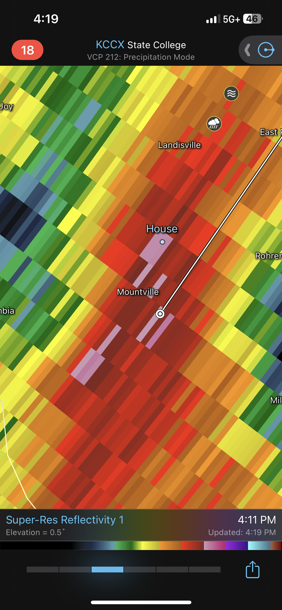
That actually popped right over my house but the wife reports no hail. Just gusty tree tops, heavy rain, and some thunder. Sounds a lot like what I had with last night’s storm.
-
Central PA Summer 2023
Mount Joy Snowman replied to canderson's topic in Upstate New York/Pennsylvania
The accuracy of this post is just......stunning. You sir, are a god damn board legend. -
Central PA Summer 2023
Mount Joy Snowman replied to canderson's topic in Upstate New York/Pennsylvania
Impossible!