TimB
-
Posts
17,229 -
Joined
Content Type
Profiles
Blogs
Forums
American Weather
Media Demo
Store
Gallery
Everything posted by TimB
-

Western PA/Pittsburgh Winter 2021/22 Discussion
TimB replied to meatwad's topic in Upstate New York/Pennsylvania
And we have a few more days of snowpack to enjoy before temps blast back up near 40 on Sunday, Monday and Wednesday. -
Western PA/Pittsburgh Winter 2021/22 Discussion
TimB replied to meatwad's topic in Upstate New York/Pennsylvania
That’s just climo around here. The radar was completely filled in for hours and hours yesterday when it was 33 degrees, now we perfectly catch the hole in the radar when we have a chance at anything good. -
Western PA/Pittsburgh Winter 2021/22 Discussion
TimB replied to meatwad's topic in Upstate New York/Pennsylvania
Is it just me, or do I not really see any more precip behind this band that is set to cross the immediate Pittsburgh area, and precip will wrap up soon? -
Western PA/Pittsburgh Winter 2021/22 Discussion
TimB replied to meatwad's topic in Upstate New York/Pennsylvania
NWS recorded a total of 0.28” of ice accretion just before midnight so the warning seems to have panned out. A bit of ice and sleet and maybe a half inch of snow here. -
Pittsburgh/Western PA Banter & Complaint Thread
TimB replied to blackngoldrules's topic in Upstate New York/Pennsylvania
On 1/19/19. Literally the worst storm bust of our lifetimes*. *Until the MLK storm of 2022. -
Pittsburgh/Western PA Banter & Complaint Thread
TimB replied to blackngoldrules's topic in Upstate New York/Pennsylvania
Dear God, I just skimmed through this whole thread to catch up. Literally nothing changes, it’s @KPITSnowcomplaining about busts and (you can’t make this stuff up!) the same upstate NY guy that was throwing around snow maps in our wx thread today was bragging about how much snow he got on 1/19/19 a couple pages back in this thread. -
Western PA/Pittsburgh Winter 2021/22 Discussion
TimB replied to meatwad's topic in Upstate New York/Pennsylvania
But also yes, throw the blasted GFS out. It suggested we’d be below freezing all day. I’m writing my representative and telling him I don’t want another penny of my taxes going toward the GFS. Update: I did and his response was “what’s the GFS?” (Kidding, but it wouldn’t surprise me.) -
Western PA/Pittsburgh Winter 2021/22 Discussion
TimB replied to meatwad's topic in Upstate New York/Pennsylvania
The version that includes sleet, sure. -
Western PA/Pittsburgh Winter 2021/22 Discussion
TimB replied to meatwad's topic in Upstate New York/Pennsylvania
Still hopeful here. We have to get something before we bounce back close to 40 virtually every day next week, right? Forgot how quick winter begins to unravel as soon as the calendar flips to February in the last 10 years or so. -
Western PA/Pittsburgh Winter 2021/22 Discussion
TimB replied to meatwad's topic in Upstate New York/Pennsylvania
We’d have also dryslotted instead of having 8 straight hours of precip. -
Western PA/Pittsburgh Winter 2021/22 Discussion
TimB replied to meatwad's topic in Upstate New York/Pennsylvania
HRRR is a degree or two too warm initially, but looks like it doesn’t hit 32 in Pittsburgh until midnight. -
Western PA/Pittsburgh Winter 2021/22 Discussion
TimB replied to meatwad's topic in Upstate New York/Pennsylvania
Especially uncropped android screenshots. That might be the most infuriating part. -
Western PA/Pittsburgh Winter 2021/22 Discussion
TimB replied to meatwad's topic in Upstate New York/Pennsylvania
I would imagine a full day of 33 and rain would feel similar to if your team made the Super Bowl 4 years in a row and lost all of them, to put it in perspective. -
Western PA/Pittsburgh Winter 2021/22 Discussion
TimB replied to meatwad's topic in Upstate New York/Pennsylvania
I know what you were pointing out, and I was impressed for all of 13 seconds (see what I did there?). -
Western PA/Pittsburgh Winter 2021/22 Discussion
TimB replied to meatwad's topic in Upstate New York/Pennsylvania
Sensitive? What, am I supposed to be impressed that upstate New York is getting hammered with snow like they do basically every day of every winter? -
Western PA/Pittsburgh Winter 2021/22 Discussion
TimB replied to meatwad's topic in Upstate New York/Pennsylvania
I agree. Upstate New Yorkers who get more snow in an average season than we’ve ever gotten in any season need to stop flexing their totals. Like, we get it. They’re getting a foot or two of snow, like they do several times every winter. At some point it stops being impressive. -
Western PA/Pittsburgh Winter 2021/22 Discussion
TimB replied to meatwad's topic in Upstate New York/Pennsylvania
On the one hand these storms are fun to track and we knew the p-type at this hour would almost certainly be plain rain, but on the other hand it’s agonizing to watch it rain all day wondering if/when we’ll get any return on investment. -
Read a few discussions from PBZ and then complain about anything CTP does.
-
Western PA/Pittsburgh Winter 2021/22 Discussion
TimB replied to meatwad's topic in Upstate New York/Pennsylvania
Operational models are trending much closer to a seasonable look for Feb with intrusions of above normal heights from time to time (and some below). Ensembles haven’t yet come to that conclusion. Simply put, I feel like we have to score a few inches on the back end of this to get us through a period that might not be as productive for us. -
Western PA/Pittsburgh Winter 2021/22 Discussion
TimB replied to meatwad's topic in Upstate New York/Pennsylvania
In these situations, the warmest guidance often wins so I wouldn’t be surprised if the Canadian nails it. -
My wife has a master’s degree and I guarantee you she has no idea what a NWS forecast discussion is or where to find one. Probably also didn’t know prior to seeing me looking at weather models that there was a place where peons like you or I could see the GFS run every 6 hours, or even what the GFS is.
-
Western PA/Pittsburgh Winter 2021/22 Discussion
TimB replied to meatwad's topic in Upstate New York/Pennsylvania
HRRR and the like even have modest warming (a degree or two) before it starts to cool back down. It’s these kinds of storms that make me realize how much I don’t know about weather. -
Western PA/Pittsburgh Winter 2021/22 Discussion
TimB replied to meatwad's topic in Upstate New York/Pennsylvania

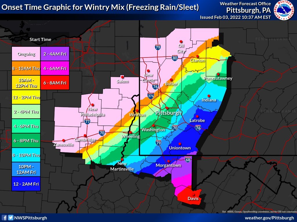
-
Western PA/Pittsburgh Winter 2021/22 Discussion
TimB replied to meatwad's topic in Upstate New York/Pennsylvania
Looks like that wind shift occurred at around 3:00 this morning at PIT and between 4:00 and 5:00 at AGC. -
Western PA/Pittsburgh Winter 2021/22 Discussion
TimB replied to meatwad's topic in Upstate New York/Pennsylvania
Would think that most of those factors work against efficient ice accretion during the day today even in areas that are below 32.