

TimB
-
Posts
17,229 -
Joined
Content Type
Profiles
Blogs
Forums
American Weather
Media Demo
Store
Gallery
Everything posted by TimB
-

Western PA/Pittsburgh Winter 2021/22 Discussion
TimB replied to meatwad's topic in Upstate New York/Pennsylvania
I would say it shifted a good bit south. The 12z run had basically no snow through daybreak Friday, this one has a warning level snow. And the lack of zr, while good, is a massive change. -
Western PA/Pittsburgh Winter 2021/22 Discussion
TimB replied to meatwad's topic in Upstate New York/Pennsylvania
18z HRRR is interesting. Basically goes straight from rain to sleet in Pittsburgh. -
Western PA/Pittsburgh Winter 2021/22 Discussion
TimB replied to meatwad's topic in Upstate New York/Pennsylvania
Good thing the warning starts at 4am so people can panic about their morning commute in a 39 degree rain. -
Western PA/Pittsburgh Winter 2021/22 Discussion
TimB replied to meatwad's topic in Upstate New York/Pennsylvania
Might be the first time I’ve yawned while reading a winter storm warning. -
Western PA/Pittsburgh Winter 2021/22 Discussion
TimB replied to meatwad's topic in Upstate New York/Pennsylvania
If you have to be stuck somewhere, I’d suggest it be anywhere but work. -
Western PA/Pittsburgh Winter 2021/22 Discussion
TimB replied to meatwad's topic in Upstate New York/Pennsylvania
In theory, an advisory gets issued for areas that even see as much as a drop of freezing rain, right? -
Western PA/Pittsburgh Winter 2021/22 Discussion
TimB replied to meatwad's topic in Upstate New York/Pennsylvania
Thing is, the ensembles generally have moved back to a below normal temp look for much of the period, which I think is a good thing. -
Western PA/Pittsburgh Winter 2021/22 Discussion
TimB replied to meatwad's topic in Upstate New York/Pennsylvania
Until 18z, we can pretend. -
Western PA/Pittsburgh Winter 2021/22 Discussion
TimB replied to meatwad's topic in Upstate New York/Pennsylvania
-
Western PA/Pittsburgh Winter 2021/22 Discussion
TimB replied to meatwad's topic in Upstate New York/Pennsylvania
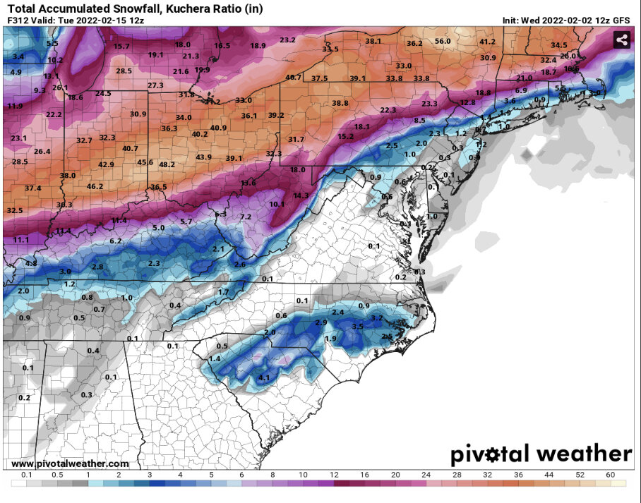
Just for fun at this point, but this is an incredible GFS run. Snowstorm, Arctic outbreak, rinse and repeat. We have 27” piled up through hour 300, parts of SW Ohio are pushing 4 feet. -
Western PA/Pittsburgh Winter 2021/22 Discussion
TimB replied to meatwad's topic in Upstate New York/Pennsylvania
32 line seems to be advancing a little faster on the Canadian. Of course, that means we get pounded with ice. -
Western PA/Pittsburgh Winter 2021/22 Discussion
TimB replied to meatwad's topic in Upstate New York/Pennsylvania
I wouldn’t trust the RAP at this range but it did go from 1.4” of snow on its previous extended run to pushing double digits on this one. -
Western PA/Pittsburgh Winter 2021/22 Discussion
TimB replied to meatwad's topic in Upstate New York/Pennsylvania
Do I? Does anyone? -
Western PA/Pittsburgh Winter 2021/22 Discussion
TimB replied to meatwad's topic in Upstate New York/Pennsylvania
0.76” ice and 5.9” snow plus what looks like a couple inches of sleet. -
Western PA/Pittsburgh Winter 2021/22 Discussion
TimB replied to meatwad's topic in Upstate New York/Pennsylvania
Verbatim, the GFS is probably the worst case scenario from a practical (non-weenie) perspective. Enough ice to knock out the power, a bunch of snow and temperatures plunging well below zero Saturday morning. Brutal. -
Western PA/Pittsburgh Winter 2021/22 Discussion
TimB replied to meatwad's topic in Upstate New York/Pennsylvania
Hey, just because we don’t do snow well doesn’t mean we can’t do literally every other p-type very well. -
Western PA/Pittsburgh Winter 2021/22 Discussion
TimB replied to meatwad's topic in Upstate New York/Pennsylvania
Would imagine this means they’re considering upping ice totals… -
Western PA/Pittsburgh Winter 2021/22 Discussion
TimB replied to meatwad's topic in Upstate New York/Pennsylvania
Oh for sure, warm advection will push the rain line further north than modeled 9 times out of 10, and even if this is that rare exception, I suppose ice totals would be reduced by the fact that some of the event is occurring during the day with temps close to freezing and ground temperatures probably above freezing in many instances. -
Western PA/Pittsburgh Winter 2021/22 Discussion
TimB replied to meatwad's topic in Upstate New York/Pennsylvania
Actually that HRRR run is an unmitigated disaster. Upwards of an inch of zr in a band from the airport through Wexford. -
Western PA/Pittsburgh Winter 2021/22 Discussion
TimB replied to meatwad's topic in Upstate New York/Pennsylvania
HRRR has 33-34 and rain in and around the city through at least 6pm tomorrow, while a steady freezing rain falls all day near the airport. -
Western PA/Pittsburgh Winter 2021/22 Discussion
TimB replied to meatwad's topic in Upstate New York/Pennsylvania
Would guess that the warm air holds on long enough not to snarl the PM commute, but people drive like idiots in rain too. -
Western PA/Pittsburgh Winter 2021/22 Discussion
TimB replied to meatwad's topic in Upstate New York/Pennsylvania
Southeast tier of CLE counties got an advisory, while the rest of their counties got a warning, if that’s any indicator of what product PBZ issues today. -
Western PA/Pittsburgh Winter 2021/22 Discussion
TimB replied to meatwad's topic in Upstate New York/Pennsylvania
Solid swath of 6” across Allegheny County. -
Western PA/Pittsburgh Winter 2021/22 Discussion
TimB replied to meatwad's topic in Upstate New York/Pennsylvania
More zr than 18z total. -
Western PA/Pittsburgh Winter 2021/22 Discussion
TimB replied to meatwad's topic in Upstate New York/Pennsylvania
Of course they will, but pretty sure PBZ leads the nation by a wide margin in watches that get downgraded to advisories.


