TimB
-
Posts
17,206 -
Joined
Content Type
Profiles
Blogs
Forums
American Weather
Media Demo
Store
Gallery
Everything posted by TimB
-

Fall 2022 Pittsburgh/Western PA Discussion
TimB replied to Ahoff's topic in Upstate New York/Pennsylvania
Looks like today’s high of 59 will be the first September day since 2014 that did not get to 60. -
Fall 2022 Pittsburgh/Western PA Discussion
TimB replied to Ahoff's topic in Upstate New York/Pennsylvania
Still have a shot at a slightly below normal September with the upcoming forecast. -
Fall 2022 Pittsburgh/Western PA Discussion
TimB replied to Ahoff's topic in Upstate New York/Pennsylvania
The numbers seem to bear out that even in late September last year it was an up and down pattern. I’m not saying we don’t get a miserable stretch in October, but we only had 3 days last September with highs in the 60s and none were consecutive. -
Fall 2022 Pittsburgh/Western PA Discussion
TimB replied to Ahoff's topic in Upstate New York/Pennsylvania
NWS blames Fiona for locking in our chilly pattern in their forecast discussion. The Euro makes next week look especially chilly with lots of highs in the 50s. GFS allows the Midwest ridge to encroach a little more and keep us cool but not unseasonably. Of course, by the end of the Euro run, the yet to be named storm is in our backyard, so it seems our weather is going to be heavily influenced by what’s going on in the tropics for the foreseeable future. -
Fall 2022 Pittsburgh/Western PA Discussion
TimB replied to Ahoff's topic in Upstate New York/Pennsylvania
Really starting to look like a pretty drastic change mid to late week. This warm stretch doesn’t look unbearable either. -
PA is entirely inside it on one clown range panel of the 12z GFS.
-
Fall 2022 Pittsburgh/Western PA Discussion
TimB replied to Ahoff's topic in Upstate New York/Pennsylvania
Second summer arrives this weekend and sticks around for who knows how long. My bet is on longer rather than shorter. -
Fall 2022 Pittsburgh/Western PA Discussion
TimB replied to Ahoff's topic in Upstate New York/Pennsylvania
As far as I can tell, the fall record for lows of 60 or above is 16 (13 if you only include the KPIT era). We’re at 5 now, and although we could have a few close calls the next few nights, the official NWS forecast does currently have us tacking on at least another week with no 50s so we could get close. -
Fall 2022 Pittsburgh/Western PA Discussion
TimB replied to Ahoff's topic in Upstate New York/Pennsylvania
Speaking of “not egregiously warm” patterns and “mostly warm lows.” When we analyze recent Septembers next year at this time, we’ll see a pattern that wasn’t miserable, but the ground truth is pain. -
Fall 2022 Pittsburgh/Western PA Discussion
TimB replied to Ahoff's topic in Upstate New York/Pennsylvania
Who do I have to sell my soul to for a September that actually feels like fall? -
Pittsburgh/Western PA Summer 2022 Discussion
TimB replied to Ahoff's topic in Upstate New York/Pennsylvania
Seconded. Today’s 6z is comical. -
Pittsburgh/Western PA Summer 2022 Discussion
TimB replied to Ahoff's topic in Upstate New York/Pennsylvania
Anyhow, GFS and EC are now way out of phase during that period mid-next week. GFS looks near-record hot under a massive ridge, EC has a trough in the east and near perfect conditions. -
Pittsburgh/Western PA Summer 2022 Discussion
TimB replied to Ahoff's topic in Upstate New York/Pennsylvania
Think 2017, when our 90s were 6/13, 9/24 and 9/27. -
Pittsburgh/Western PA Summer 2022 Discussion
TimB replied to Ahoff's topic in Upstate New York/Pennsylvania
I wouldn’t rule out a 90 in September, this pattern looks decisively above normal. I know it will take a +12 to +15 departure to get to 90 in the first half of September, but the GFS in particular is putting us at or above 90 at some point in almost every run. -
Leinie’s is one of the few that sold out to the big guys that I still buy. Good beer.
-
Chippewa Falls, eh?
-
Pittsburgh/Western PA Summer 2022 Discussion
TimB replied to Ahoff's topic in Upstate New York/Pennsylvania
So the infamous record low max of 25 on 4/18/1875 might have really been 21 or 22? -
Pittsburgh/Western PA Summer 2022 Discussion
TimB replied to Ahoff's topic in Upstate New York/Pennsylvania
And that’s also a good point. If we’re going to keep the absolute garbage records from the 1800s in the record books, maybe I shouldn’t worry about the sanctity of a record that was likely broken by a bad ASOS sensor four years ago. One other interesting note: PIT recorded a high of 60 on 9/9/18 with the allegedly bad sensor while the high at AGC was 57. The record low max for that date is 58, and a high of 57 or less would have not only been a record low max, but the earliest such high temperature in the season on record. -
Pittsburgh/Western PA Summer 2022 Discussion
TimB replied to Ahoff's topic in Upstate New York/Pennsylvania
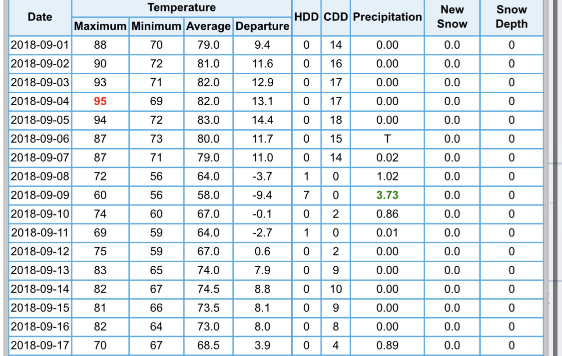
An excellent analysis, thank you. Have you ever analyzed September 2018? I’ve lamented before that I think something is wrong with PIT’s data (which includes a record high on 9/4). PIT: AGC: PIT ran 3.15 degrees above AGC for the first 10 days of the month, then promptly was on par with or slightly below AGC from the 11th on. The part that is particularly suspect to me is the 4-8(!) degree discrepancies on the 8th through the 10th (the duration of the remnants of Gordon), which seems nearly impossible during an area wide steady rain under completely overcast skies.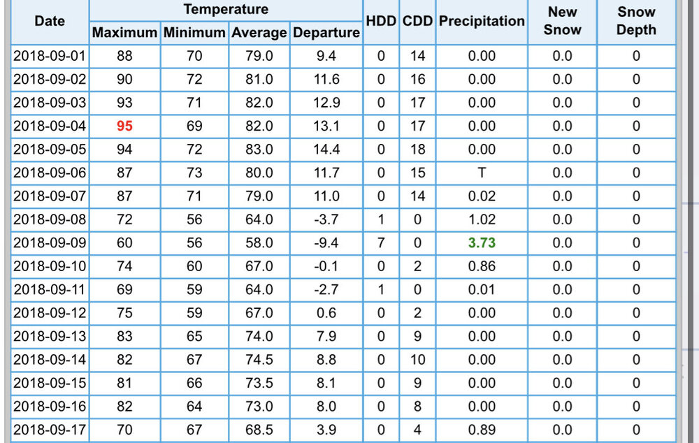
-
Pittsburgh/Western PA Summer 2022 Discussion
TimB replied to Ahoff's topic in Upstate New York/Pennsylvania
But can you draw up a much better late afternoon in late summer than this? A fair amount of sun, a light breeze, falling dew points and temperatures just a hair below normal. Only thing that would make it better is if it were the weekend, and at least the first half of the weekend looks to be a carbon copy of what we have right now. -
Pittsburgh/Western PA Summer 2022 Discussion
TimB replied to Ahoff's topic in Upstate New York/Pennsylvania
What an ugly day. So much cloud cover so far in August. I’m ready for the sunshine starting tomorrow. Have to remind myself it’s already cooler and less humid than it’s been the past several days, but looking out the window it doesn’t look any different. -
Pittsburgh/Western PA Summer 2022 Discussion
TimB replied to Ahoff's topic in Upstate New York/Pennsylvania
I’m ready. Hope we’re not sacrificing fall to get this pattern in mid-August, but we’re in desperate need of some 70s/50s highs and lows. -
Pittsburgh/Western PA Summer 2022 Discussion
TimB replied to Ahoff's topic in Upstate New York/Pennsylvania
It’d be a lot easier to say “something isn’t right” if it weren’t for that pesky 3 at HLG, where the elevation, latitude, and climo are remarkably similar to PIT’s. The location of AGC is a bit more firmly within the UHI area, which would conceivably lead to a few more 90 degree days in what has been an above normal temperature summer. My question (and maybe yours) isn’t whether or not PIT’s data is bad, but whether PIT is representative of the greater Pittsburgh area, and it very well may not be. But to change that now would render the past 70 years of data moot and not able to be compared to data going forward. And 1952-2022 is unfortunately a pretty critical part of the climate record. -
Yep, hopefully this pattern doesn’t persist in a few months.
-
Winter storm warning in parts of northern Alaska. That’s gotta be rare in early August even for there.