

TimB
-
Posts
17,206 -
Joined
Content Type
Profiles
Blogs
Forums
American Weather
Media Demo
Store
Gallery
Everything posted by TimB
-
 Once the 500 anomalies on the GEFS go red over our area next Tuesday, they stay red for the remainder of the run.
 -
Continues to crush our back end snow dreams. You know that’s how it’s going to play out too.
-
Probably. I don’t spend much time thinking about what that model shows for any situation.
-
To the extent that the Ukie matters, it’s now showing 0.2” of snow.
-
GEFS is now almost certain that the front comes through in the morning. The spread at 12z is 11/54, spread at 18z is 2/18. Would like to believe for practical, non weather weenie purposes that it’s probably better if this happens earlier in the day.
-
Important to note, though, that the ensembles 10th/90th percentiles for 18z Friday still show an absolutely massive range. On the CMC ensemble, these numbers are 4 and 57 degrees.
-
12z guidance so far seems to be showing that we’ve crashed into the low teens or single digits by that timeframe.
-
Yeah, looks like the front comes through early enough that at least we don’t get midnighted on Saturday. I’m just concerned that we overperform if we get any sunshine and no snow cover. I didn’t realize the low max for Christmas Eve was so attainable (13). I knew about the 0 on Christmas 1983, but I didn’t realize just how impressive that was. Looks like the next coldest December high in the last 100 years was 7.
-
Am I the only one who isn’t all that impressed with the magnitude of the cold even behind the frontal passage? With the lack of snow cover, NWS is already going high on temps for the holiday weekend. Highs in the upper teens and lows in the upper single digits. Meh. We got cold of that magnitude pretty much every winter up until the last few winters when it became nearly impossible to get a high below 20.
-
The Euro solution has us dry slotting just in time for the potential snow. GFS also has the dry slot feature, but it’s still in a location where we can get some snow.
-
The problem I’m seeing with the back end snow potential is that the Euro, which sniffed out the cutter in the first place long before the GFS did, has started a disturbing trend of virtually no snow on the back end (about 1” on the 0z). For what it’s worth, the UKMET agrees with this garbage. So do the It’s probably prudent to lower our expectations yet again. Edit: with the exception of the GEFS, the ensembles are on board with this solution too. Probably the biggest gut punch since 1/19/19.
-
Pittsburgh/Western PA Banter & Complaint Thread
TimB replied to blackngoldrules's topic in Upstate New York/Pennsylvania
Yeah, I’d like to air a grievance about how we need to have absolutely perfect conditions to get a decent snowstorm around here these days. I feel like it wasn’t always this way. Everything cuts now. Hope our 3 days of cold is fun for everyone and then we get to watch the MJO slog through 4-5-6 for a few weeks. -
Saturday, Sunday and Monday will be cold with an inch of snow on the ground. What, you wanted more from this winter?
-
3” would be acceptable. 1-2 would be a gut punch.
-
We’ll always take the bonus snow, plus decent model trends.
-
Well yeah, prevailing wisdom seems to be that February could be ugly so hoping we can have a solid January.
-
So how long do yinz think the warm spell that’s coming a few days after Christmas is going to last?
-
True. We were in the same boat last Dec. 17 and we made it.
-
I guess at the end of the day, maybe we just need to be happy with the fact that we managed to get two above normal snow seasons out of 3 Niñas in a row.
-
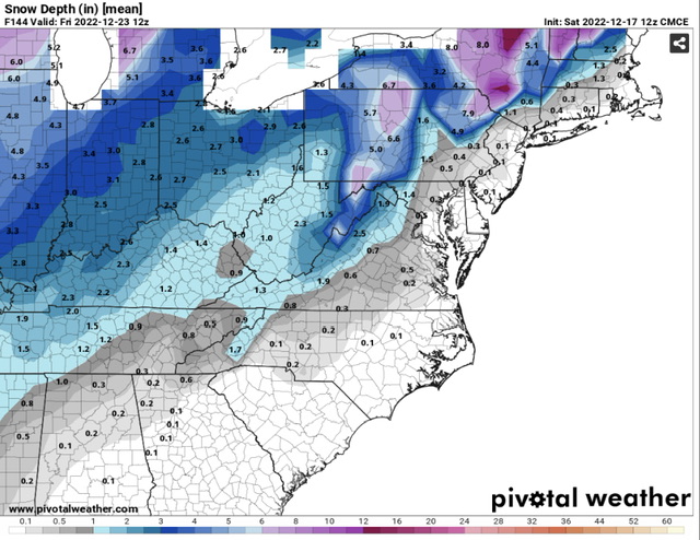
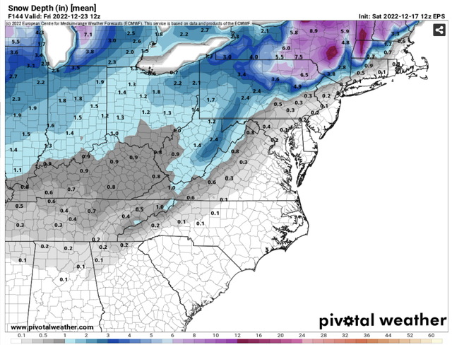
When I look at any of these snow depth maps for 12z Christmas morning all I can see is blades of grass poking through the snow and bare spots in any areas that may have gotten any degree of sun on Saturday or where the wind behind the Arctic front drifted the snow.
-
18z GFS looks like it’s coming in with the most boring depiction of this thing yet.
-
I like the “maybe it’ll shift back east” mentality better than the 1/19/19 “we may have lost the storm but at least we’ll get a couple inches on the back end with the Arctic front” mentality. Not sure the east shift is something we should count on, but getting some snow on the back end that the grass is still poking through is hardly a silver lining. Edit: Euro has barely any precip on the back end after the changeover. Maybe an inch. That’s probably the most likely scenario, not an advisory level amount.
-
GFS becomes the next domino to fall. Absolutely comical.
-
I would assume “it happened once on a GFS run” is more than enough to say it’s possible.
-
Unfortunately, we have to accept that it’ll probably cut further west than that. But it’s fun to look at for the next few hours. Kuchera is up over 30”.


