.jpg.949052775cf13715749e9bd3740a4bd3.jpg)
Bigbald
-
Posts
253 -
Joined
-
Last visited
Content Type
Profiles
Blogs
Forums
American Weather
Media Demo
Store
Gallery
Everything posted by Bigbald
-
What is going on with the gfs to get that low east of the apps? Ive noticed the RGEM tries to do that as well this run, is that a transfer?
-
I put the backseat down and have a car mattress in mine ready to go if the house cools. I expect to lose about 20% of battery a day if I do have to get in it.
-
Great time to own an electric vehicle. On a full charge in cabin mode you could run toasty 75-80 degree cabin for 4-5 days non-stop.
-
When all else fails phone Orlando
-
Gfs comes out one last time to bait us once more
-
Thats exactly where we need it to be!
-
This is a tough one to watch go but it sure looks like a trend to end in significant rain up the valley, not sure anyone east tn will have snow to show by the end.
-
Does Cherokee stay open throughout the storm durations? I know Bristol Hardrock opens but has a hard time staffing.
-
Its only like 80 miles difference where the low starts to turn north between the 12z gfs and 12z euro Ai. That 80 miles from mobile to Florida has huge implications.
-
John (or anyone else with a long memory), what was the weather like in the days that followed 93' bliz and 96' bliz? I was a teenager, it seems like it was pretty cold after 96, and warmed fairly quick after 93.
-
They do a remarkable job of working the roads from jc to beech/sugar. To my friends that dont ski they are shocked we are able to go during, or just after a good snow, and I have to explain they throw alot of resources at it to keep these places open. That being said, I cant imagine making the trip for this one and with the cold that follows. I think I will try and give it 72 hrs after the storm clears. I bet the slopes will be epic.
-
Id have to believe Leconte is 4 or 5 feet, google says it got 5 feet in 93', not sure if thats technically 24 hrs or over the entire system.
-
With the qualifier euro run tenn valley location. Dgex used to show these depictions weekly! I cant see the rest of the run but id love to
-
This has to be an all timer modeled amount within 5 days
-
My interest in the 18z gfs is icon level. The fall from grace of the gfs has been remarkable, what has happened?!
-
My goodness, 12z Euro Ai, CMC, GFS have the 2nd system coming into focus next wednesday.
-
I have noticed some mets getting on board for upper east tn, fairly unusual this far out.
-
Its very conspicuous how a few days back that 12z model suite initially snapped onto a broadly speaking agreeable solution after meandering through wild swings of inconsistencies. Seems like alot of our bigger events catch on like that.
-
True that, but at least this isnt 250 hrs out. The first depicted system from 12z is 125-160 hrs out.
-
Its kind of amazing how quick the models snapped onto the 12z solution. Wonder how/why models went from all the variance to locking in like that.
-
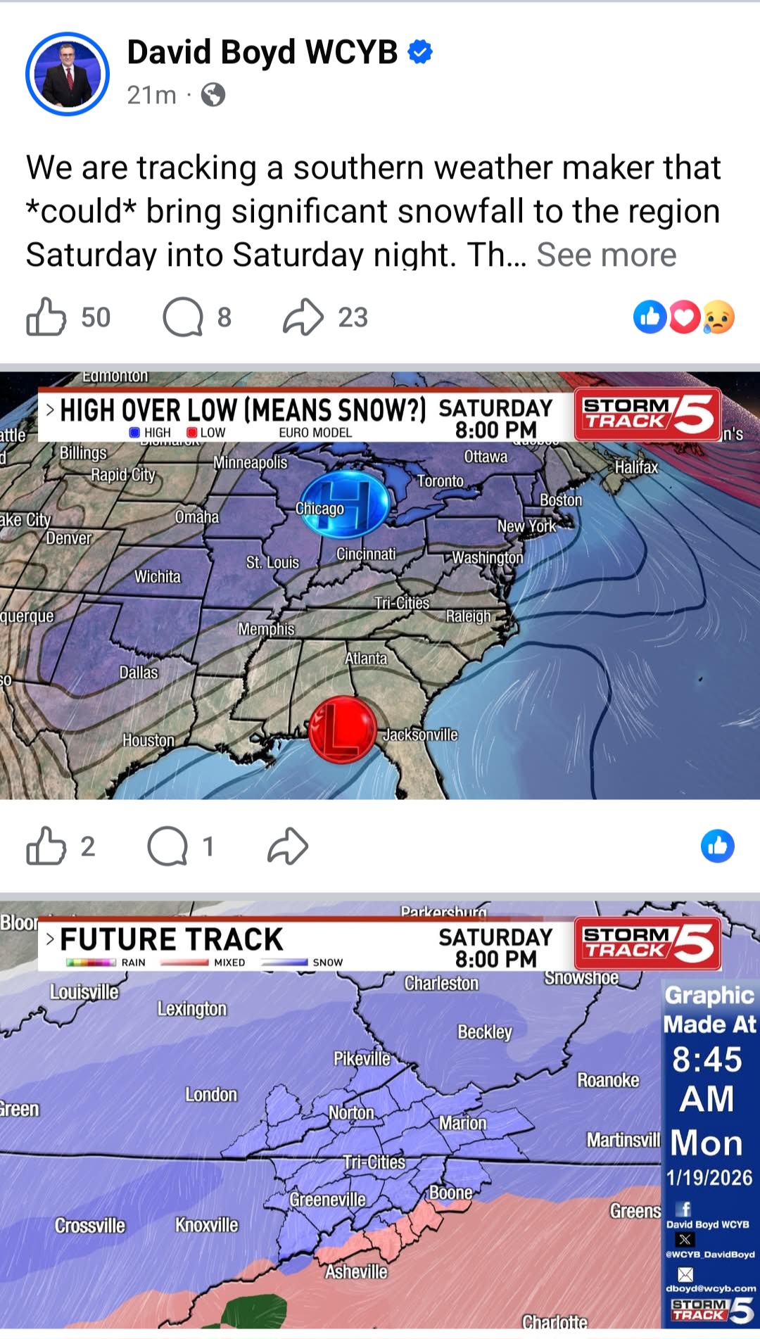
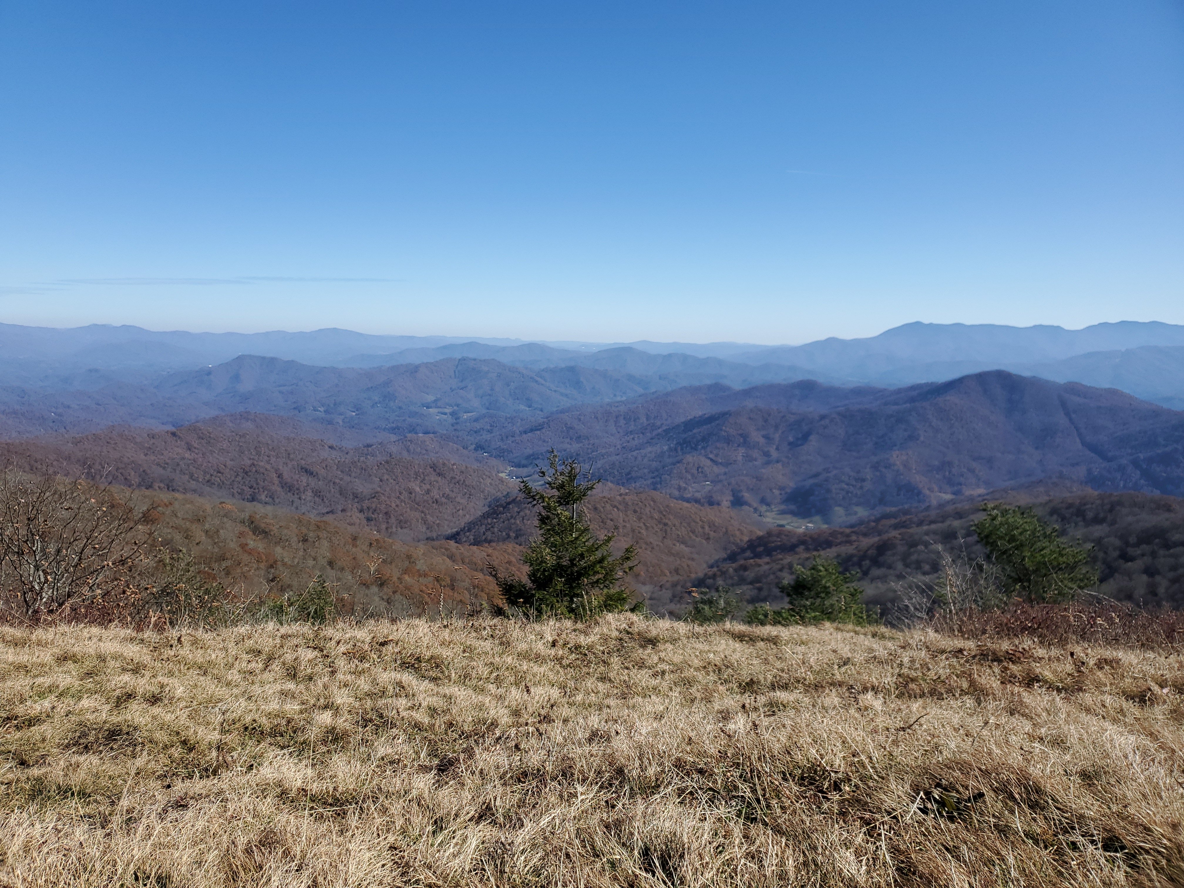
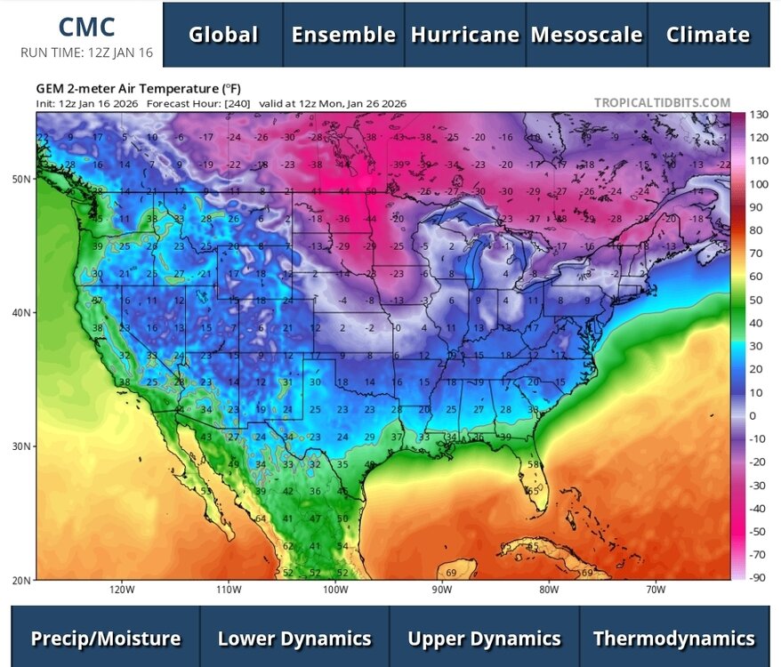
At 240 on CMC that lobe of -35 temps is heading east with a gigantic snow cover in place.
-
RGEM very westerly.
-
It could save us all alot of sleep and heartache ha. I am honestly surprised it hasnt happened sooner for Ai weather when you consider driving a car has big safety consequences for getting it wrong.
-
I have no doubt AI weather modeling will soon figure it out and weather following as we know it will look much different. In 2 years of owning a self driving car I basically had a front row seat watching how fast this stuff transforms. The early versions of the self driving car were damn near scary at times. The newest rendition is like having a perfect chaffeur drive me. That transformation occurred in less than 2 years.
-
It truely is remarkable how often we go from a good looking solution 8-10 days out, to medicore as 6 days approach...to hopefully we can get 1-3 inches 4-5 days.... at 48 hrs maybe we can see some flakes ha. Yet it almost never works in the reverse.
.thumb.jpg.9707d4addca3d84715ae3d888c5c10d6.jpg)