wx_observer
-
Posts
256 -
Joined
-
Last visited
Content Type
Profiles
Blogs
Forums
American Weather
Media Demo
Store
Gallery
Everything posted by wx_observer
-
Just north of it, yes.
-
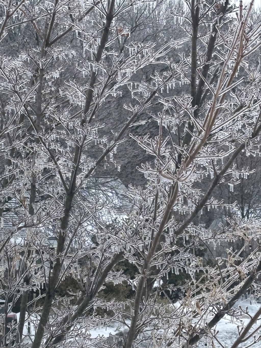
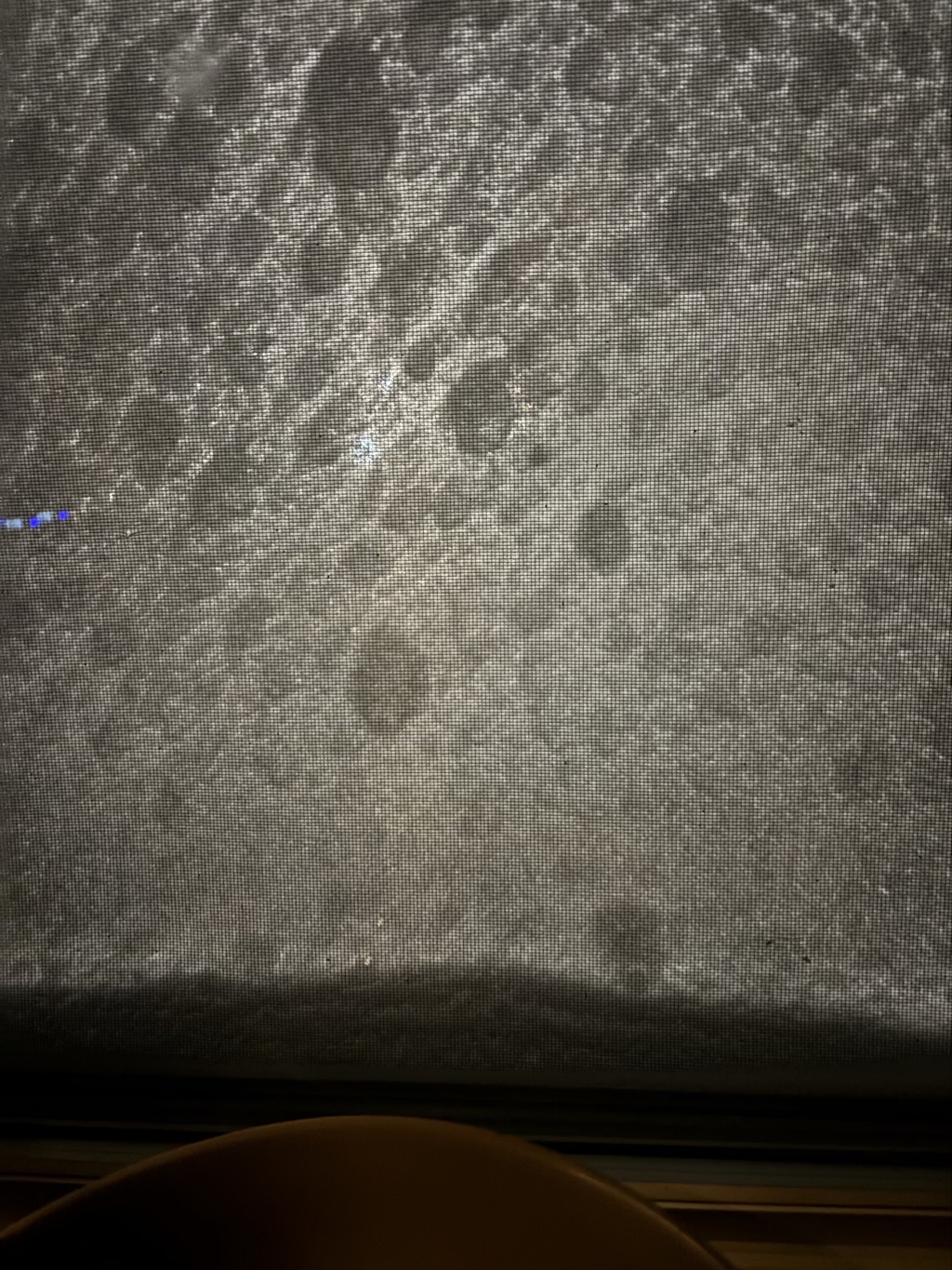
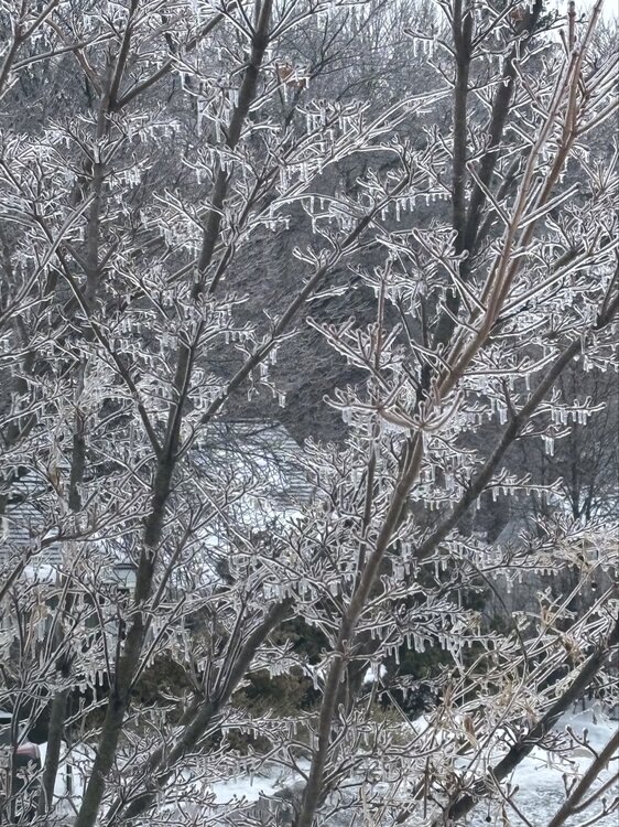
Temps were borderline for ice here. You can tell by the amount of drippy icicles on everything, rather than a thicker radial coating.
-
-
31F and light freezing rain. Must have gotten a batch of heavy freezing rain last night though. All the tree branches have that grey haze of ice on the branches, and my 7 ft holly bush is so heavy with ice that it's drooping halfway over.
-
That's a pretty beefy band of precip just north of the pike west or Worcester. Could have some moderate icing if that all falls in as freezing rain when it gets here.
-
31 F and pure freezing rain here. Ice is starting to accumulate on branches. Hoping we don't stay all ice. 10PM BOX maps have me at 20-30% chance of getting over .5" of ice accumulation.
-
Down to 33F in Central MA...was 44 at midday here
-
Sorry to be a buzzkill, but I'll take a hard pass on that much freezing rain.
-

"Don’t do it" 2026 Blizzard obs, updates and pictures.
wx_observer replied to Ginx snewx's topic in New England
And this was with Cat 1 winds and without fully leafed trees. Not that it can get much worse for the Cape itself...but makes you wonder how further inland might fare in a Cat 2 hurricane when the trees are fully leafed out. -
"Don’t do it" 2026 Blizzard obs, updates and pictures.
wx_observer replied to Ginx snewx's topic in New England
Historic, indeed. https://www.wcvb.com/article/blizzard-prompts-boston-globe-management-to-call-off-printing-paper-for-first-time-in-153-years/70475083 -
"Don’t do it" 2026 Blizzard obs, updates and pictures.
wx_observer replied to Ginx snewx's topic in New England
If he got stuck in the snow hole, we'll never hear the end of it. -
"Don’t do it" 2026 Blizzard obs, updates and pictures.
wx_observer replied to Ginx snewx's topic in New England
I'm right at the edge of the western edge of the death band, and the winds are really howling. Maybe the strongest so far. -
"Don’t do it" 2026 Blizzard obs, updates and pictures.
wx_observer replied to Ginx snewx's topic in New England
At least the state was at least smart enough to pre-position a lot of resources down that way. Hopefully that helps with restoration. -
"Don’t do it" 2026 Blizzard obs, updates and pictures.
wx_observer replied to Ginx snewx's topic in New England
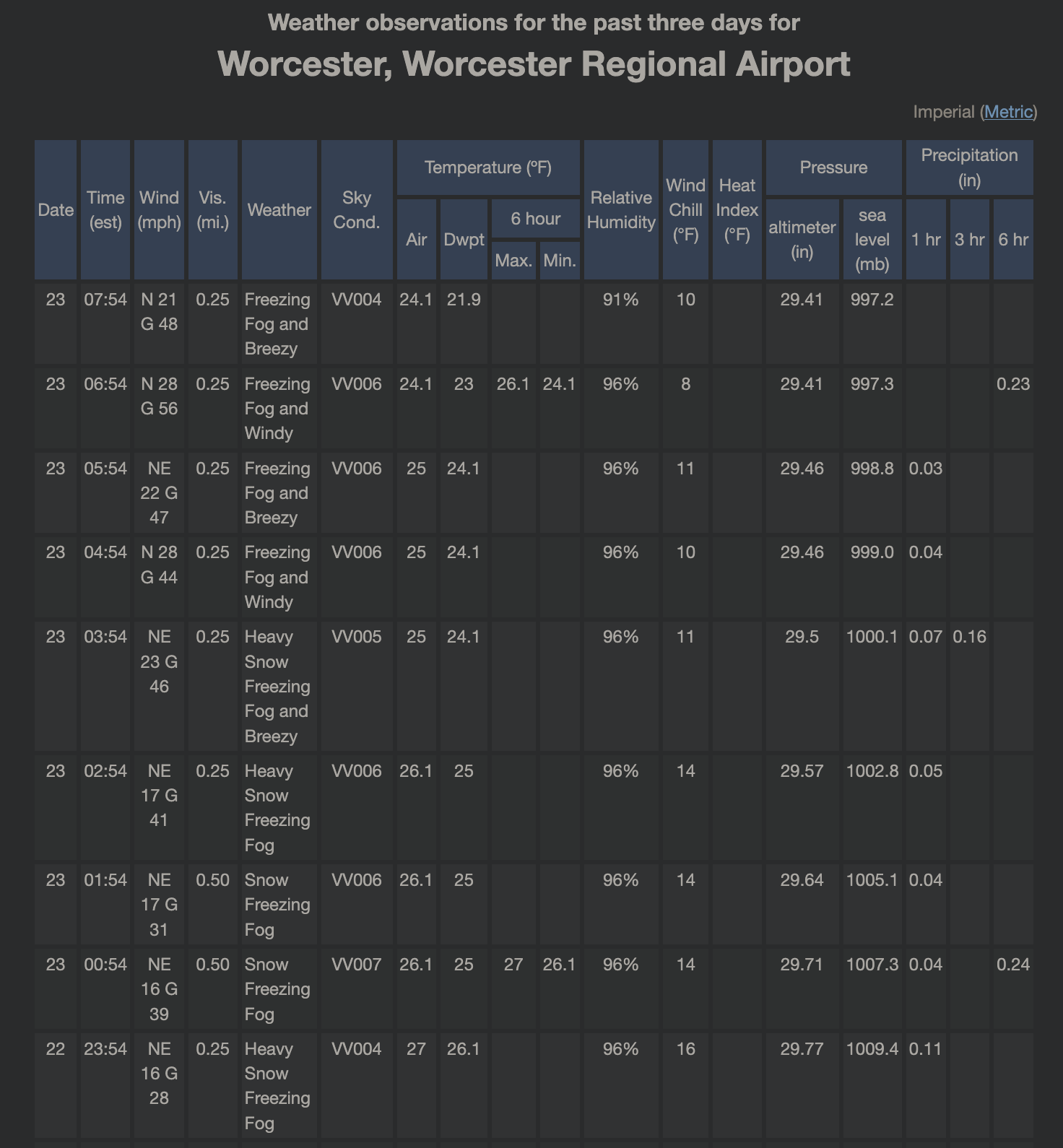
A bit short on the 35 mph sustained winds, but Worcester Airport is reporting visibility of .25 miles for 6 consecutive hours. I'm not far from there, and we've had consistent, moderate snow here. Not sure where the freezing fog is coming from. Maybe snow covered sensors?
-
"Don’t do it" 2026 Blizzard obs, updates and pictures.
wx_observer replied to Ginx snewx's topic in New England
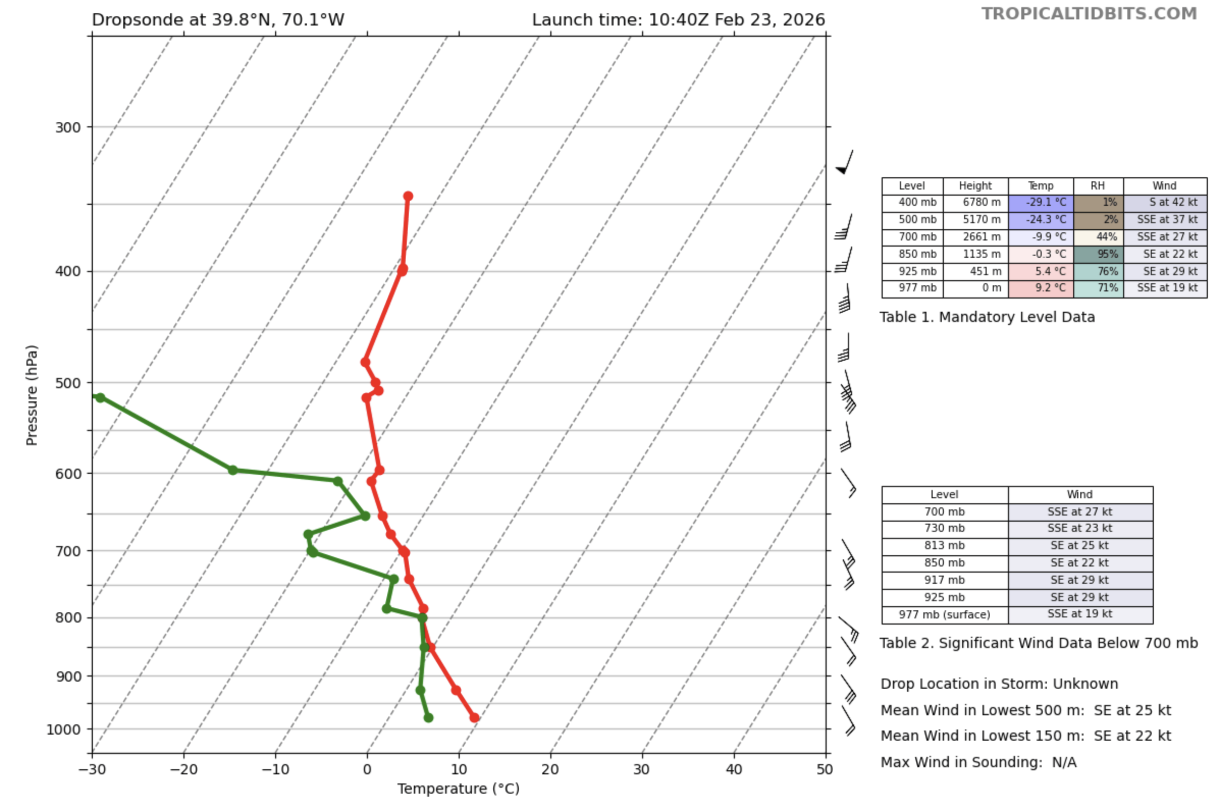
977 MB surface pressure at the dropsonde closest to the storm center. https://www.tropicaltidbits.com/recon/
-
"Don’t do it" 2026 Blizzard obs, updates and pictures.
wx_observer replied to Ginx snewx's topic in New England
Gorgeous on GOES. That center is unbelievable!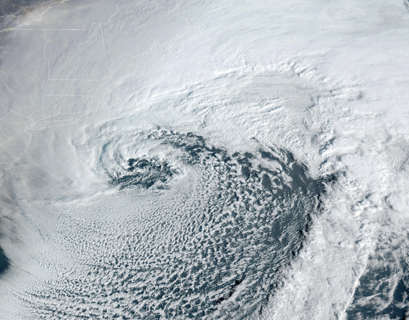
-
"Don’t do it" 2026 Blizzard obs, updates and pictures.
wx_observer replied to Ginx snewx's topic in New England
Any idea how much further N/W the RI death band gets? -
"Don’t do it" 2026 Blizzard obs, updates and pictures.
wx_observer replied to Ginx snewx's topic in New England
I have a traffic light .3 miles from me that isn't visible anymore. Visibility is waaaay down...maybe approaching blizzard conditions here. -
"Don’t do it" 2026 Blizzard obs, updates and pictures.
wx_observer replied to Ginx snewx's topic in New England
Man, I hope the outage tracker website is wrong--it has almost 40% on the cape without power. -
"Don’t do it" 2026 Blizzard obs, updates and pictures.
wx_observer replied to Ginx snewx's topic in New England
I like how this site breaks it down by county. Over 20% of Nantucket without power, according to this. https://poweroutage.us/area/state/massachusetts -
"Don’t do it" 2026 Blizzard obs, updates and pictures.
wx_observer replied to Ginx snewx's topic in New England
Good morning from my south facing window. Central MA. Moderate snow, but just on the edge of the heavier band trying to push north of the turnpike. Winds have been moderate with some stronger gusts. Eyeball's guess is that there's maybe 6" out there so far.
-
"Don’t do it" 2026 Blizzard obs, updates and pictures.
wx_observer replied to Ginx snewx's topic in New England
Wind is really picking up now in central MA. Will be a good test for my neighbor's dubiously constructed / installed flagpole 50 feet from my window. In these stronger gusts, the top of the pole is almost a foot away from where it should be. -
"Don’t do it" 2026 Blizzard obs, updates and pictures.
wx_observer replied to Ginx snewx's topic in New England
Look at that eye starting to form...where is the center compared to what was forecast? -
“Cory’s in NYC! Let’s HECS!” Feb. 22-24 Disco
wx_observer replied to TheSnowman's topic in New England
Marco looks prepped to be honorary goalie for 10 seconds...before being pulled off the ice in favor of an empty net. -
“Cory’s in NYC! Let’s HECS!” Feb. 22-24 Disco
wx_observer replied to TheSnowman's topic in New England
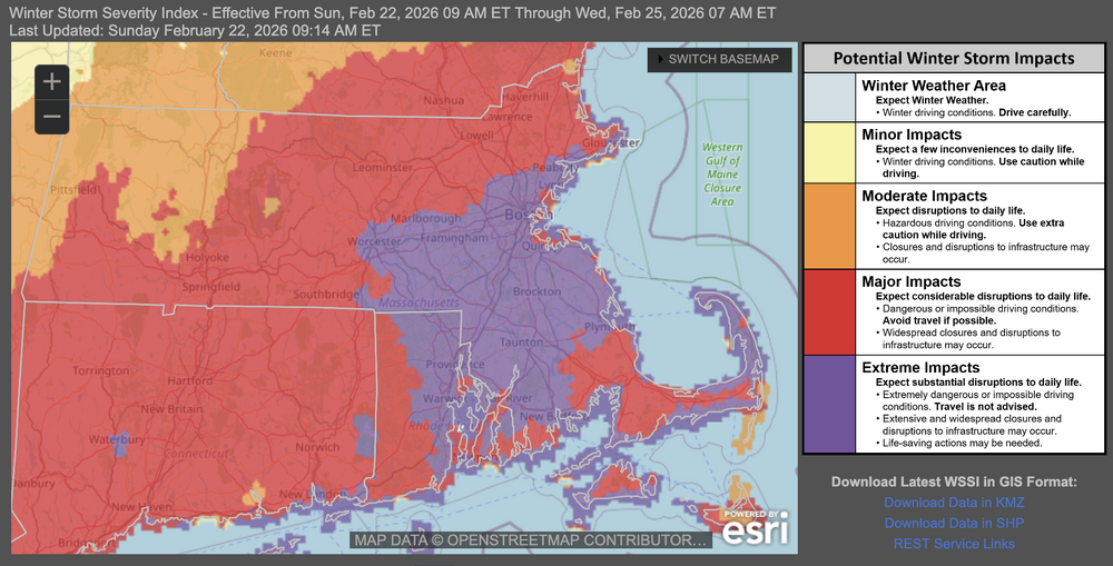
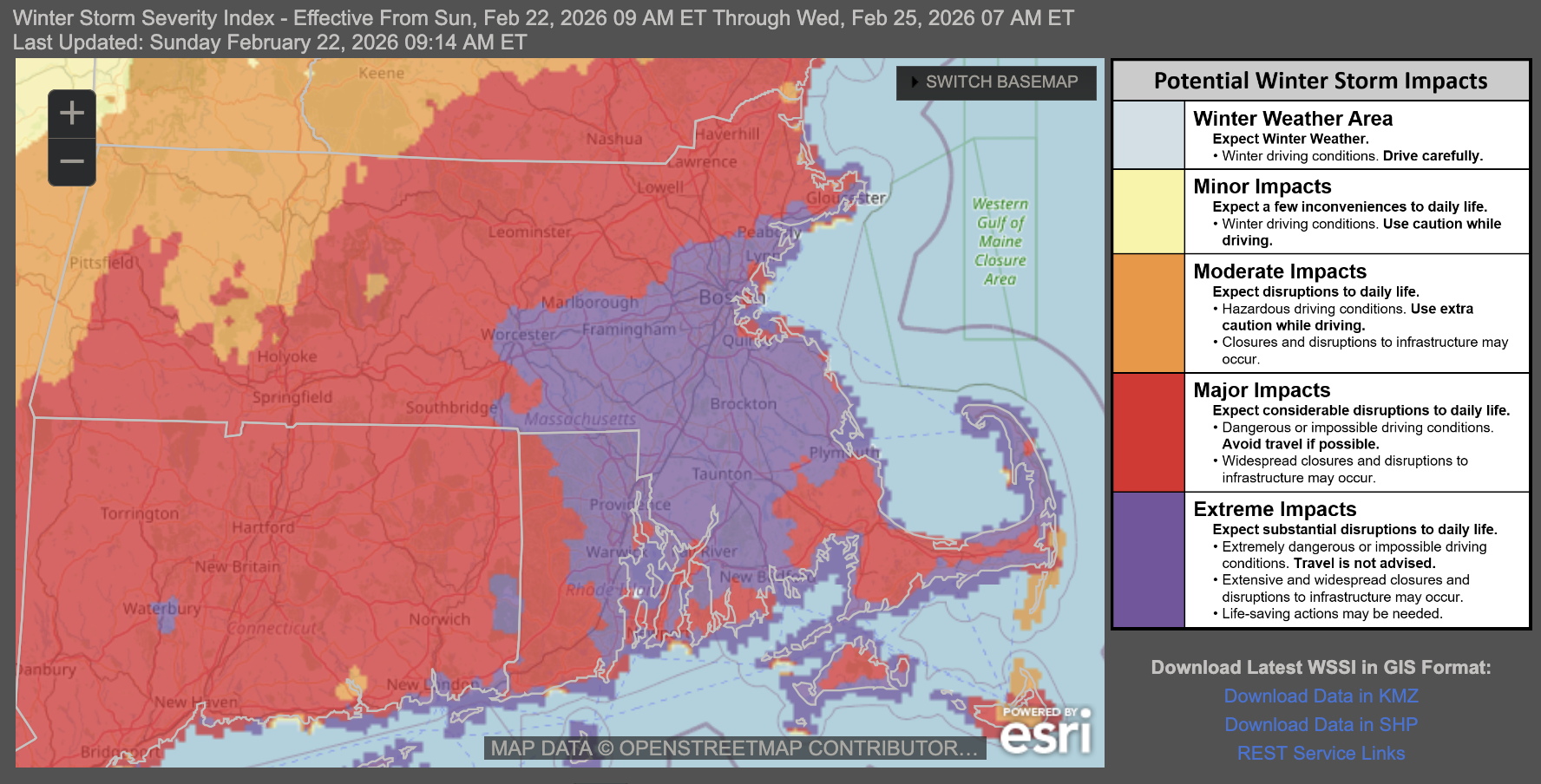
Latest WSSI pushes extreme impacts back to Worcester