

SnowenOutThere
-
Posts
5,616 -
Joined
-
Last visited
Content Type
Profiles
Blogs
Forums
American Weather
Media Demo
Store
Gallery
Everything posted by SnowenOutThere
-
Totals
-
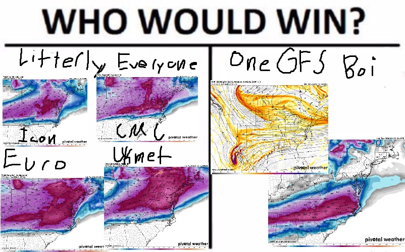
CMC would be a hit from hour 84 extrap.
-
Yk... if you got that NS energy to phase a bit further by digging more west we'd be looking at a HECS for the east coast up to NYC
-
Does anyone have that site that the CMC runs on for 18z?
-
These streams are so close but just refusing to interact so far. It's not squishing our storm too badly though so I don't hate it.
-
Need to see if we can pull off the phase here and get into some truly historic territory
-
GFS managed to clear the main failure scenario of keeping the SW too far back. Now we get to see how it handles the interaction with the open wave and NS which will be key in determining who gets the major snowstorm.
-
Like I said in my yesterday analysis we just need that first phase out west to get the SW moving east and were golden for a major snowstorm somewhere over the east coast. Speaking of which the GFS will be coming back to the fold after its 12z adventures
-
Hey, what college do you go to and what are you studying! I'm a student at UVA planning to major env sci and politics. Good to have another college kid on here.
-
I'm going 4-8 for the low end "floor" (though would feel so much better about that if the GFS locks in!) and 14-18 for the high end ceiling.
-
True but also we extrapolate the NAM even for 2 inch snowstorms. Its more so a "fun" exercise akin to repeatedly administering electronic shocks to yourself.
-
Will start on my Synoptic Analysis Two post after we see how the GFS goes. In other news I meet with my microclimate professor who handed me a 500 page book of "Atmospheric Science an Introductory Survey by John Wallace and Peter Hobbs" to read before I might start doing research (was told to focus on the physics behind the storms as apparently "I learned meteorology from the weather forum" didn't cut it). Additionally, I apparently am being added to a group chat of grad students and professors who've been debating this storm.
-
Anyone know when this will be integrated into the models @high risk @MillvilleWx @WxUSAF
-
Love to see less southern outliers on the ENS 12z 6z You can also see a stronger Tennessee valley handoff signal as well on 12z.
-
I wonder if the rates might be underdone by 10:1 ratios if we get a deep DGZ with moisture. Additionally, it wouldn't surprise me if we get some supper fluffy snow at some points which piles up nice and quick.
-
I was also having a bit of a crash out from some Feb 20th flashbacks with that GFS run. Though with the GEFS still looking that solid we're fine unless the Euro tries to ruin our lives. Just want to see the GFS move back to us at 18z and we'll be all good.
-
-
Man say what you will about the UK but it has been extremely steady on both precip max and distribution since yesterday.
-
GEFS holds a bit more energy back (not surprising) but generally seems fine.
-
Alright, I have now found something to doom on. We can't afford a meet in the middle or even give much ground at all to how the GFS handles the SW if we want an ICON/CMC storm. I think we will know the flavor of the storm by tonight 0z or tomorrow 12z at the latest for what happens out west.
-
We need the first phase to be nearly perfect with next to no southern energy left behind for a HECS. For 6z this looked like a good consensus but now with 12z shifting the other way I agree its time to put those talks on hold till we see which way it goes at 18z and 0z.
-
I was hoping with our 6z consensus we were out of the woods with the first phase handling out west. Agree that we still have to get through at least 0z tonight now... Additionally, the GFS coming to the normal solution before shifting back is worrying to me. Probably means we meet somewhere in the middle which would still be okay for us.
-
Love the CMC look but agree we probably don't want to see anymore south shifts due to the SW being held back
-
CMC will be fine
-
CMC is a step towards the Euro (and I guess technically the GFS but its not even in the same realm). Though I didn't love how amped it was so for now its fine for it to move slightly that way.


