Forecast discussion out of Houston Texas is really something
LONG TERM [Friday Night Through Thursday]...
*** OVERVIEW ***
* Surge of Arctic air arrives on Saturday with temperatures
approaching freezing across most of the area by Sunday night.
* First of two disturbances arrives on Saturday, bringing mostly
rain with higher chances of mixed precip north of I-10.
* Second system arrives late Sunday into early Monday. With
colder temperatures in place, widespread wintry precipitation could
impact most of the area during this time.
* Behind the second system, prolonged stretch of below freezing
and potentially historically low temperatures will last well into
next week. Another round of precipitation may arrive by mid-week.
A highly impactful and potentially historic period of prolonged cold
temperatures with multiple episodes of winter precipitation is
expected to impact SE Texas over the next week. With persistent deep
surface high pressure in place over the central CONUS, arctic air
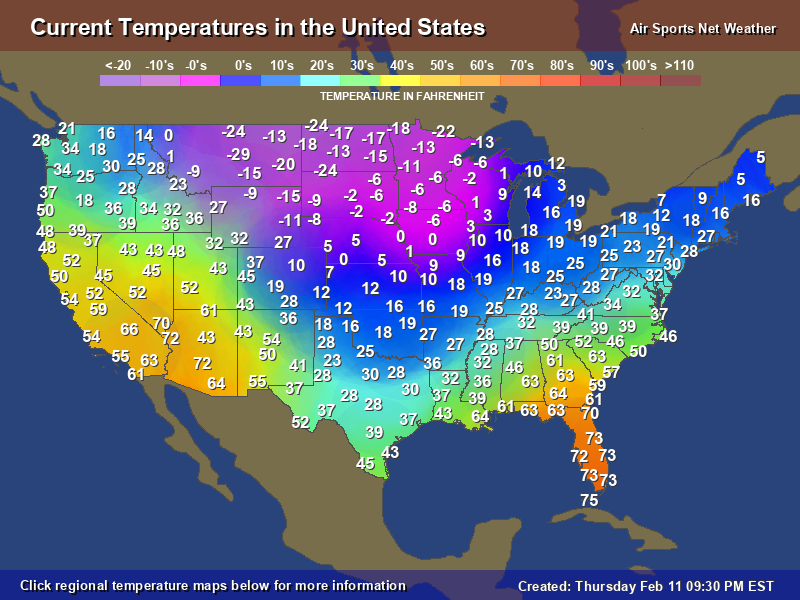
will continue to push into the area as we head into the weekend. By
Saturday, high temperatures are unlikely to break out of the mid-40s
with lows approaching freezing north of the Houston metro. Our first
shot at winter precipitation will arrive on Saturday evening as an
upper shortwave trough pushes through the area. Precipitation type
will be highly dependent on the timing of this feature, though a
period of freezing drizzle/mixed-phase precipitation may occur north
of the Houston metro but elsewhere to the south model soundings
continue to favor a cold rain.
Our main area of focus continues to be the arrival of a second, more
amplified shortwave on late Sunday into early Monday. As this
feature pushes towards SE TX and develops a slight negative tilt,
GFS/EC solutions indicate the formation of an associated coastal low
over the western Gulf of Mexico. PWs will remain in the vicinity of
1-1.25 in as this feature continues to develop, and model soundings
remain well-saturated. With lows on Sunday evening expected to dip
into the 20s to low 30s across the overwhelming majority of the
area, an impactful winter precipitation event is anticipated. While
precipitation type will remain highly dependent on the timing of
this system`s arrival and the exact vertical temperature profiles
present across the area (i.e. the presence and extent of an elevated
warm layer), we are becoming increasingly confident in a widespread
mixed-phase event beginning Sunday night and persisting into Monday.
Global deterministic solutions continue to indicate the possibility
of snow, sleet, and freezing rain impacting portions of the area
during this time. This will make for a particularly hazardous
commute on Monday, particularly for those who travel on elevated
roadways or bridges. Surface streets may become involved as well
given these persistent cold temperatures. Travelers are urged to
pay close attention to the latest forecast as this situation
develops. Over the next few days, timing, amounts, and types of
precipitation will become more refined as higher- resolution
guidance becomes evaluable.
Upon the exit of the second system and subsequent clearing, SE TX
looks to experience its coldest night in many years on Monday
evening. Low temperatures across the Brazos Valley and other
northern zones remain progged to drop into the single digits, while
the Houston metro is expected to reach the low to mid 10s. Along the
barrier islands and coast, temperatures will still remain well below
freezing. Daily records are likely in play for several days at each
of our climate sites. These conditions will be extremely hazardous
to the "4 P`s" - people, pets, plants, and pipes. Consider the
actions you will need to take to ensure the protection of each of
these things. Risk may be further compounded by the possibility of
power outages given the expected winter precipitation earlier in
the day and increased energy demand for the heating of buildings.
Freezing temperatures are expected to last well into the upcoming
week, with lows remaining in the 20s for at least parts of the area
through next Thursday. Another episode of winter precipitation is
possible on Wednesday/early Thursday as a third upper trough pushes
through the area, though the timing of this system and temperature
profile across the area remains highly uncertain across model
solutions.
Now is the perfect time to prepare for this period of hazardous
weather. Be sure to have multiple ways to receive weather
information and continue to monitor the forecast, particularly if
you must travel this weekend and early next week.