StormfanaticInd
-
Posts
2,065 -
Joined
-
Last visited
Content Type
Profiles
Blogs
Forums
American Weather
Media Demo
Store
Gallery
Everything posted by StormfanaticInd
-
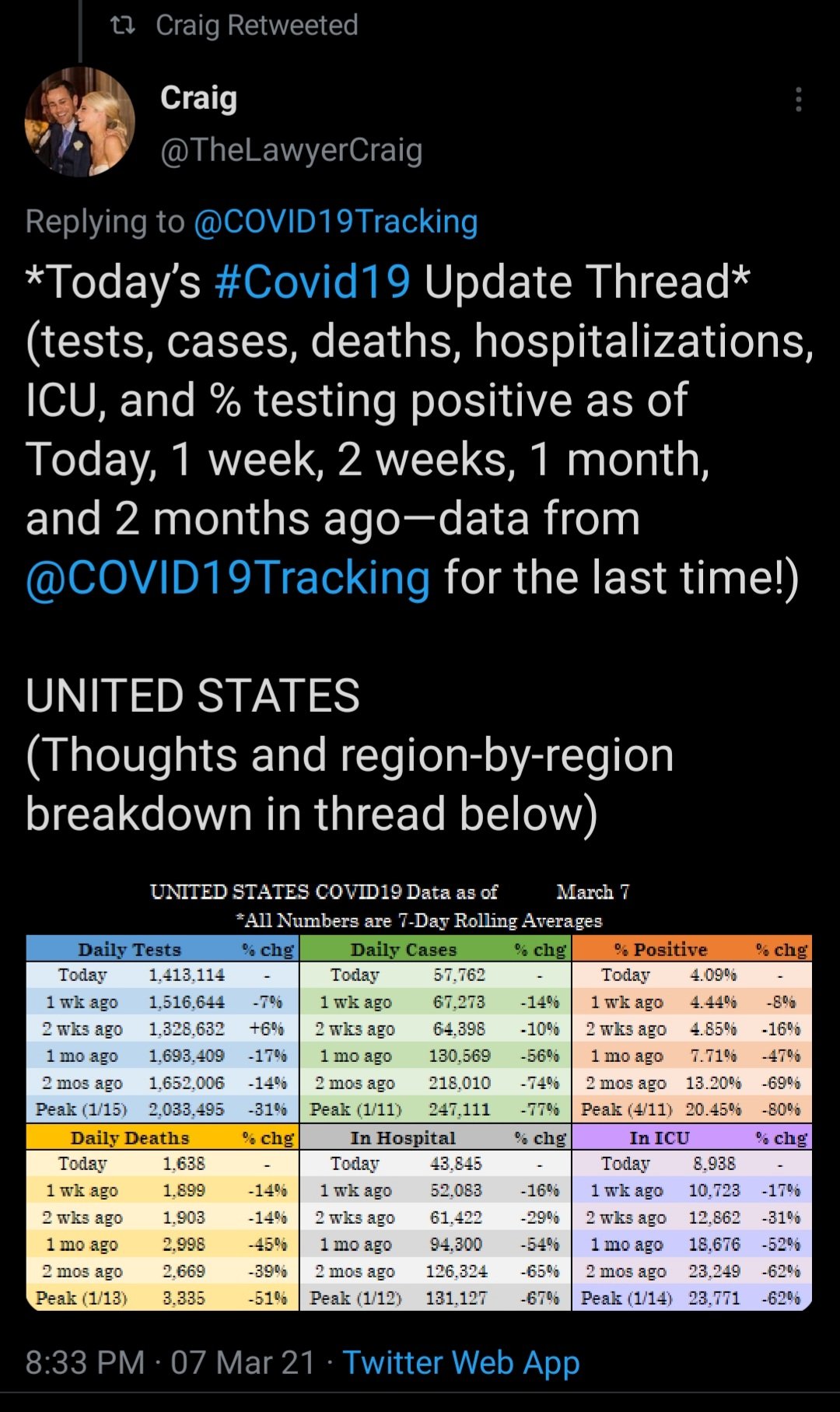
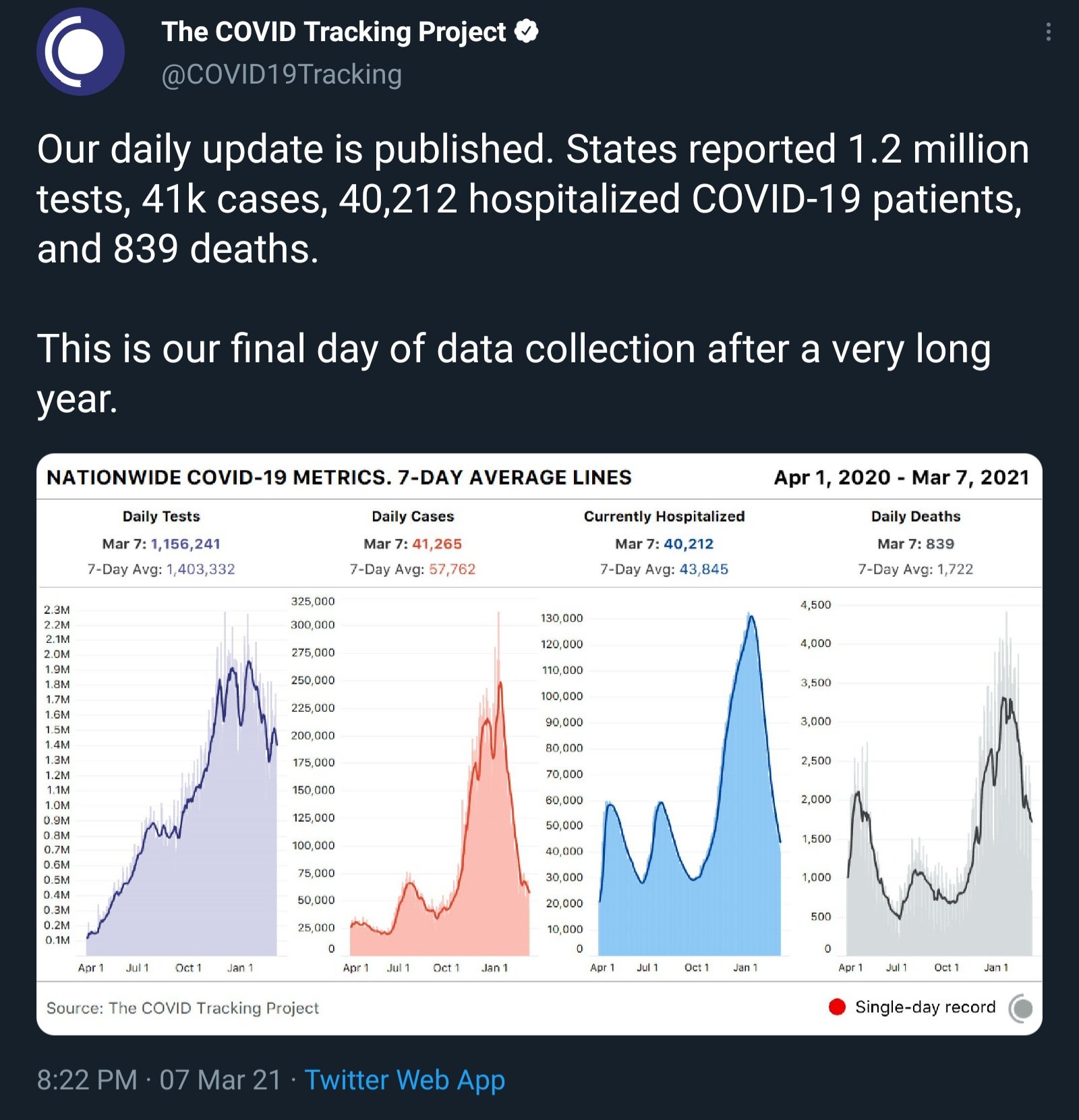
The most important thing to watch is hospitalizations. As long as that keeps declining we are in good shape
-
Only 36k cases today but we need the world to vaccinate
-
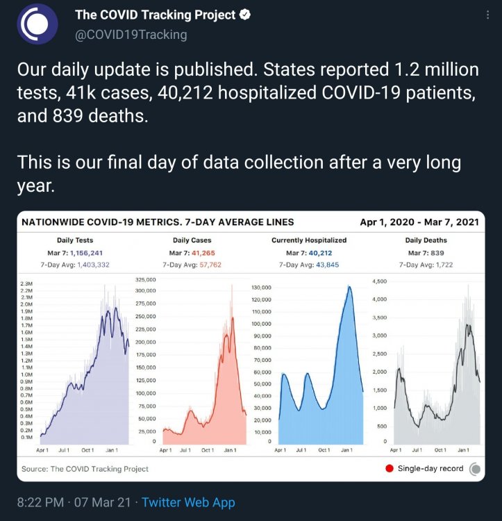
1059 deaths today. Deaths are dropping fast now
-
-
I just can't understand some of these governors
-
-
Spring 2021 Medium/Long Range Discussion
StormfanaticInd replied to madwx's topic in Lakes/Ohio Valley

-
Beware the Ides of March (and into the 16th)
StormfanaticInd replied to Hoosier's topic in Lakes/Ohio Valley
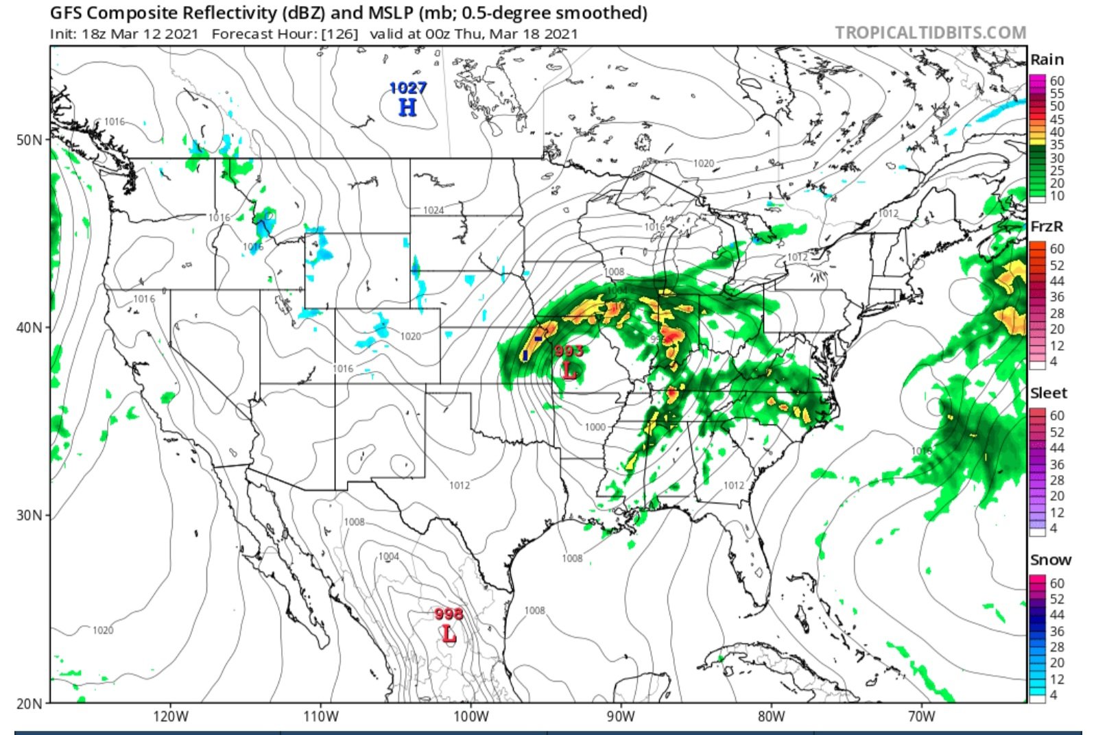
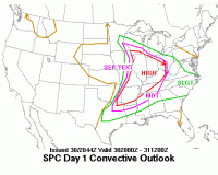
Severe weather looks possible also with this storm -
Hospitalizations now apt 37.5k
-
Pretty good convective shower here in Indy
-
Hospitalizations now at 39,148. 693 lower than yesterday
-
Hospitalizations increased a little bit today but not much
-
-
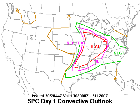
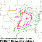
ACUS48 KWNS 080959 SPC AC 080959 Day 4-8 Convective Outlook NWS Storm Prediction Center Norman OK 0359 AM CST Mon Mar 08 2021 Valid 111200Z - 161200Z ...DISCUSSION... ...Thursday/Day 4 to Saturday/Day 6... The medium-range models begin the Day 4 to 8 period in good agreement. Model solutions show southwest mid-level flow from the south-central U.S. to the Northeast. An upper-level low is forecast over southern California. At the surface, a cold front is forecast to advance southeastward across the southern Plains, Ozarks and mid Mississippi Valley. Thunderstorm development will be possible along parts of the front during the afternoon and evening. Although instability is forecast to be weak ahead of the front Thursday afternoon, strong deep-layer shear should be adequate for at least isolated severe storms. The severe threat should extend from northwest Texas northeastward across the Ozarks and into the lower Ohio Valley. Hail and wind damage will be the primary threats. On Friday, the models continue to be in good agreement. The solutions move the upper-level low into the Desert Southwest and have an upper-level ridge in the south-central states. The cold front is forecast to move slowly southward and may stall from the southern Plains eastward into the mid Mississippi Valley during the day on Friday. Model forecasts suggest that thunderstorm development will be possible along and near the front during the afternoon and evening. The greatest potential for severe storms would be from Oklahoma eastward into Arkansas, where low-level moisture, deep layer shear and instability are forecast to be maximized. Although there is some spread among the GEFS members, on Saturday the deterministic solutions remain in relatively good agreement. The upper-level low is forecast to move into the Four Corners region as a mid-level jet moves into the southern Plains. Ahead of the approaching system, strong moisture advection is forecast in the southern Plains where a corridor of 60+ surface dewpoints appears likely by afternoon. Thunderstorms should be ongoing across parts of the southern Plains and Ozarks throughout the day. An increase in thunderstorm coverage may take place in the late afternoon and evening as instability maximizes across the region. Model forecasts show a potential for moderate instability, widespread large-scale ascent and strong deep-layer shear from the southern Plains eastward into the Ozarks. All severe threat hazards will be possible, but the magnitude and spatial extent of the severe threat will depend upon moisture return and the eastward timing of the system. ...Sunday/Day 7 and Monday/Day 8... On Sunday and Monday, the upper-level low is forecast to move eastward across the Great Plains. At the surface, a cold front is forecast to move quickly eastward from the Great Plains into the Ohio and Tennessee Valleys. Severe thunderstorms will be possible along parts of the front both on Sunday and on Monday. At this time, models suggest that the greatest severe threat will be located in eastern parts of the southern Plains and in the Ozarks on Sunday. The severe threat should shift eastward into the Ohio and Tennessee Valleys on Monday. However, uncertainty concerning the timing of the system is substantial at this extended range in the forecast period. ..Broyles.. 03/08/2021
-
Could be some severe weather this week
-
The numbers continue to improve dramatically here in Indiana. We are close to this being over. We will have to keep a wary eye on those variants but so far so good

-
This guy is taking over. He is just as good

-
I tend to follow the covid tracking project. The cdc was corrupted last year imo
-
-
I hear you. Just cheering the fact that it is dropping fast.
-
Average daily deaths now below 2k and dropping fast
-
We could hit 25k hospitalizations by the last week of this month
-
Probably will have to get a yearly shot like the flu shot