Ed, snow and hurricane fan
-
Posts
2,133 -
Joined
-
Last visited
Content Type
Profiles
Blogs
Forums
American Weather
Media Demo
Store
Gallery
Everything posted by Ed, snow and hurricane fan
-
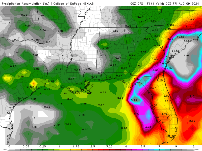
Scrolling, near the 21.57 inch 6 day rainfall I see amounts as high as 30.83 inches. The only good thing if FFS were correct is S. South Carolina, where the heaviest 6 day totals occurs have offshore winds for much of the storm, or the flooding rivers and streams at least won't be flowing into bays with water levels elevated by onshore flow. That is a major disaster if it verifies. EDIT TO ADD: I quoted a post about the Euro w/ a GFS forecast image. It is late and I should go to bed soon.
-
I see the turning down between Cuba and Jamaica near the Caymans. Bit I can also convince myself there is loose turning centered on the S coast of Cuba or just inland. If PTC 4 looks like this tomorrow, I don't think they'll upfrade without either a defined recon center of satellite being very obvious. Watches and warnings already up with PTC advisories.
-

2024 Atlantic Hurricane Season
Ed, snow and hurricane fan replied to Stormchaserchuck1's topic in Tropical Headquarters
PTC 4 appeared in the modeling with some Euro ensembles developing a storm and the number of ensembles developing a TC increased every week. PTC 4 didn't develop as quickly as some of those ensembles suggested, but for MDR development, at least for PTC 4, some Euro ensemble members seeing it, with an increase in members, until other models caught on, is how the potential tropical development was first seen. Cyclone 5, Invest 98L, maybe. Maybe not. -
If I make it into September unsuspended, I may take care of attachment size limits by donating to the board like I had for years. IN the meantime, to avoid putting up a 3 Megabyte gif, can I insert a Giphy link?
-
2024 Atlantic Hurricane Season
Ed, snow and hurricane fan replied to Stormchaserchuck1's topic in Tropical Headquarters
Remember how PTC 4 started out on modelling as just a few Euro ensemble members. I'm not sure if the ensembles are all developing the same wave.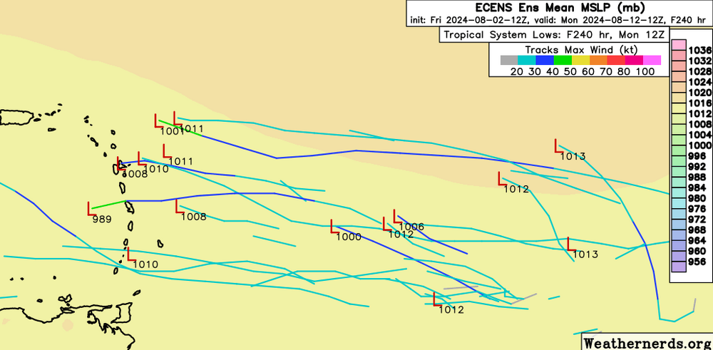
-
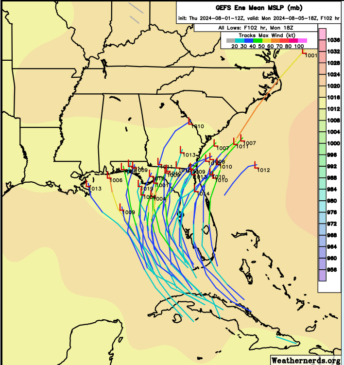
New GFS is Tampa Bay area, which, judging by Charlie and Ian, means down towards Naples or Port Charlotte, and then slowing to a crawl as it passes offshore of the OBX and erodes the beaches before the second half of August through early October.
-
18Z GEFS have fewer stalls on the Gulf Coast, although I see some perturbations that get off the coast SEUSA, then start meandering or even turning back in at 6 days. EDIT TO ADD: Some interesting members at 6 days turning back in from the Atlantic towards the Mid Atlantic.
-
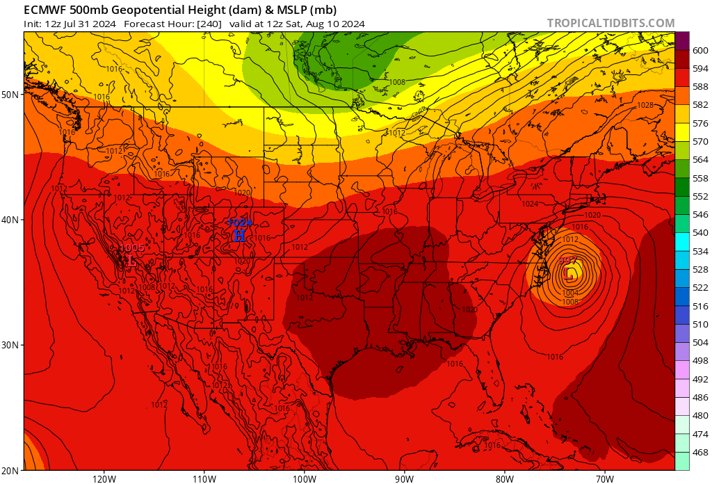
I'm all over the Euro ensemble perturbation that brings a hurricane across the Cape Cod Canal.
-
The Canadian Regional is close to the end of its modeled area, and I recall the 3 km NAM spun some Gulf storm down below 700 mb. The higher resolution non-global models are generally not used. There are high res hurricane models, but they aren't very accurate until a well defined center is formed. Tweets don't embed for me any longer here so I'm pasting the actual Tweet. Andy Hazelton @AndyHazelton · Jun 27 PSA for folks who track the tropics: hurricane models (like HAFS or HWRF) aren't really designed to be used for invests. We do our tuning and evaluation on storms that have already reached TD+. So the biases are probably larger and more unpredictable at this stage.
-
Dr. Andy Hazelton, one of the HAFS team leaders at HRD has a pinned tweet about the HAFS before a center has formed. he says don't trust it. I'll feel better tomorrow evenings (morning in Europe) models tomorrow, and even better Saturday evening/Sunday morning, as aircraft first sample around the storm tomorrow and then locate a center Saturday..
-
That shows the issue with the statistical intensity model. It initializes with a fairly well organized surface low, which doesn't reflect the reality of a low level vorticity in mountainous terrain. Still useful for seeing the likely rate of strengthening once an organized center emerges over water.
-
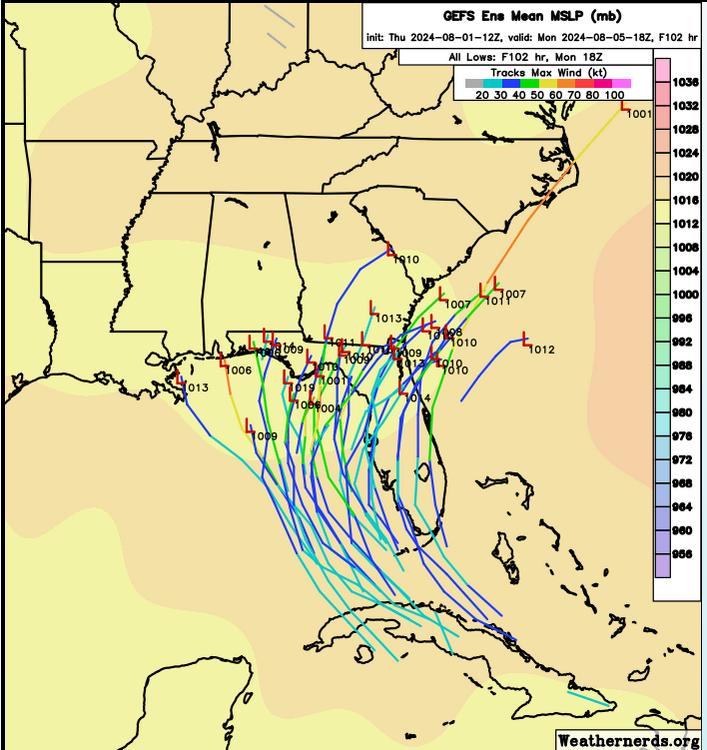
That is pretty useful, it can be used as a pseudo ensemble, and suggests a Florida Big Bend to near OBX track,
-
I used to be a donating member here, which increases file size limits. If I make a whole season w/o a suspension I may donate again.
-
WxMan57 currently buys a system moving N just off W Coast of Florida. He even has expected wind impacts, but notes without an organized center for models to work with, uncertainty in his forecast is higher than he'd like. Eyeball mean of GFS ensembles suggests Florida Big Bend but landfall location seems to be highly dependent on where the center actually forms.
-
Dr. Hazelton on Twitter notes the 'squished spider' model tracks, suggesting uncertain steering. Florida Panhandle or W. Peninsula seems most likely impact point, with a potential second landfall or near miss near OBX and marine effects New England. As noted on other weatherboards, SSTs and OHC in the E. Gulf is higher than normal, so time over water could make a large difference in intensity. I would note GFS ensembles make it clear the main determinant of where 97L goes in the next 5 days is where it forms. As I noted, LLC over mountains of DR, vigorous convection N of G. Antilles, and mid level vorticity SE of low level vorticity, or where it forms is very much in doubt. You could have edited the previous post or delete the prior post. The every 2 minute latest hour from the model stuff tends to clutter the board.
-
If we do PBP for each major model every two minutes as the next frame becomes available, 3 or 4 times a day, this will turn into a 100 page thread by the time of landfall.
-
CIMMS product shows low level vort over the Dominican Republic, where the mountains should keep development in check, and 500 mb vort to the SE of the low level vort, a bit S of the Mona Channel. A new vortmax could form N of the GA, or maybe under the midlevel vort max, but honestly, I think it is too early to call where the center develops. Excluding the extreme outliers of the ensembles, I think anywhere ensembles show a possible landfall is in play.
-
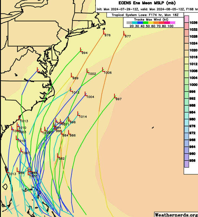
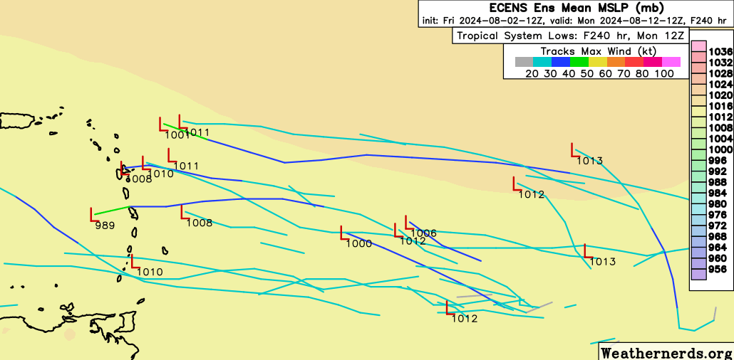
Interesting that both GFS ensembles and Euro ensembles have a fair number of members still near the coast or offshore SEUSA or in the Gulf at 10 days. The models seem to have a lot of stalled or looping members, that increases flooding risk.
-
The part with extreme rainfall somewhere along the Eastern half of the Gulf Coast seems very possible. I suspect many smaller cities right on the Gulf could handle Harvey-esque rain, but Harvey like rain in New Orleans or Tampa could produce Harvey like rains. I think a 3 day stall is a fairly low possibility. GEFS through 6 days are mostly above 1000 mb.
-
-
I'm a little weenie on New England/New York hurricanes, both of my parents remembered 1938 quite well, but a strong tropical storm with the Bermuda-Azores ridge building back in, well, not 1938, that is more likely in September or October, but a Hurricane Belle scenario, which I remembered and which, along with 1978 on Long Island, made me a lifelong Gen X weenie. I try to contain my weenieness in the tropical forum threads.
-
2024 Atlantic Hurricane Season
Ed, snow and hurricane fan replied to Stormchaserchuck1's topic in Tropical Headquarters
Enough 'popcorn' storms, that don't last long but add water vapor to a dry environment, I think this thing will go. I think Euro and ensembles will start shifting W toward other guidance, but I would not rule out an ECUSA threat. Invest tag today? -
I think its a little too early to declare a fish or Canada storm.
-
2024 Atlantic Hurricane Season
Ed, snow and hurricane fan replied to Stormchaserchuck1's topic in Tropical Headquarters
Insurance rates for coastal Texas residents unable to get private wind storm damage insurance going up. At least we're not Florida, only a small portion of the state is vulnerable to tropical storms. https://abc13.com/post/texas-windstorm-insurance-association-states-insurer-homes-businesses/15121810/ EDIT TO ADD SLIGHTLY OFF TOPIC: I have relatives in DFW, they're getting enough hail storms often enough their homeowners rates are increasing -
2024 Atlantic Hurricane Season
Ed, snow and hurricane fan replied to Stormchaserchuck1's topic in Tropical Headquarters
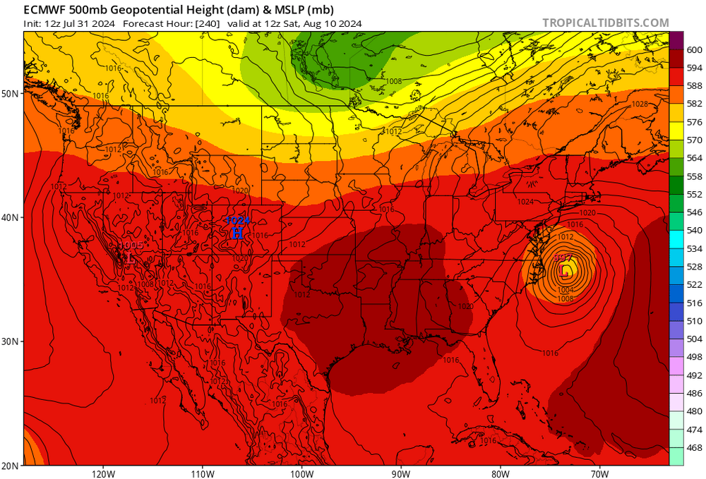
2% chance a 978 mb hurricane hits Nantucket per Euro ensembles. We'd get a lot of New England forum posters to this thread if that verifies.