Ed, snow and hurricane fan
-
Posts
2,133 -
Joined
-
Last visited
Content Type
Profiles
Blogs
Forums
American Weather
Media Demo
Store
Gallery
Everything posted by Ed, snow and hurricane fan
-

2023 Atlantic Hurricane season
Ed, snow and hurricane fan replied to Stormchaserchuck1's topic in Tropical Headquarters
Euro weeklies have a small chance something leaks into the S GOMEX from the Pacific, and an even smaller chance of something forming/leaking into the Caribbean. It seems to be saying season over. Euro enembles seem to support the slight chance of something weak in the S. GOMEX Or I still think there is a very small chance, below a normal October, for a Florida storm. First real cold front of the season in Texas is 2 weeks late, but the season is over here. But temps only in the 70s and undefeated teams playing college football at the State Fair of Texas, the end of another dead Texas season is less depressing to my inner weenie than usual. That, and with the set up we were lucky to get a Deep South Texas late developer. Death ridge could have been no season at all. -
Extra zero in 15000, and my house is only marginal, but the front Thursday looks to be a wet one as well Excessive Rainfall Discussion NWS Weather Prediction Center College Park MD 429 AM EDT Tue Oct 03 2023 Day 1 Valid 12Z Tue Oct 03 2023 - 12Z Wed Oct 04 2023 ...THERE IS A SLIGHT RISK OF EXCESSIVE RAINFALL OVER PORTIONS OF THE TEXAS COAST... ...Texas Coast... Southeasterly flow from the Gulf of Mexico will interact with a coastal trough to produce showers and thunderstorms this afternoon and early evening. Heavy rainfall is possible within the Slight Risk area, between Houston and Corpus Christi this afternoon, when instability will be at its peak (1000-15000J/Kg). There will be plenty of moisture present, despite the lack of dynamic support, with PWATs between 2-2.5" along the Texas coast. HREF neighborhood exceedance probabilities of 2-5" are reasonably high at this time so those were used as a proxy for this day 1 Slight Risk area.
-
TS Philippe & TS Rina
Ed, snow and hurricane fan replied to Windspeed's topic in Tropical Headquarters
I'm all in on a hybrid 977 mb storm NW of Spain in 10 days. -
Autumn is finally coming.

-
2023 Atlantic Hurricane season
Ed, snow and hurricane fan replied to Stormchaserchuck1's topic in Tropical Headquarters
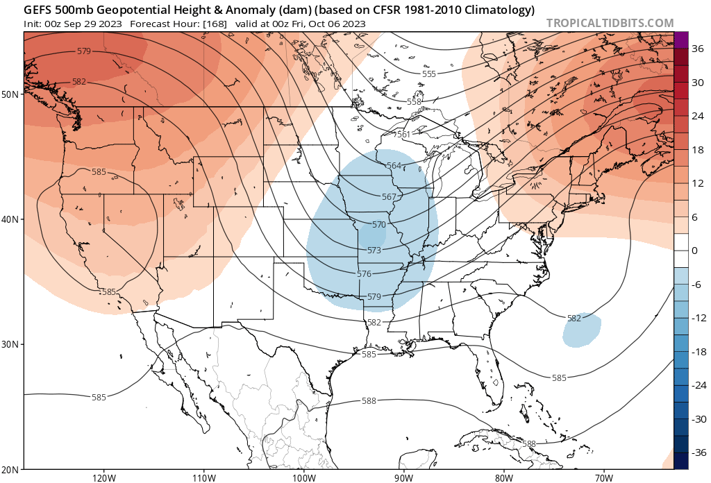
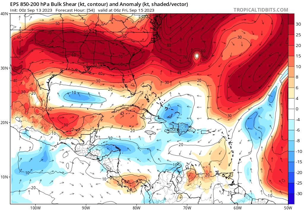
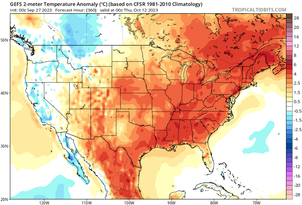
Unless something changes Florida looks safe into mid-October from Caribbean systems. Not only is shear across the Gulf strong per GEFS the entire run, it has a NW component to it. SW shear could at least ventilate a system lifting into the Gulf. SW shear didn't impact Ian negatively very much when it entered the Gulf. But NW shear and dry air should mitigate the risk for a strong Gulf system.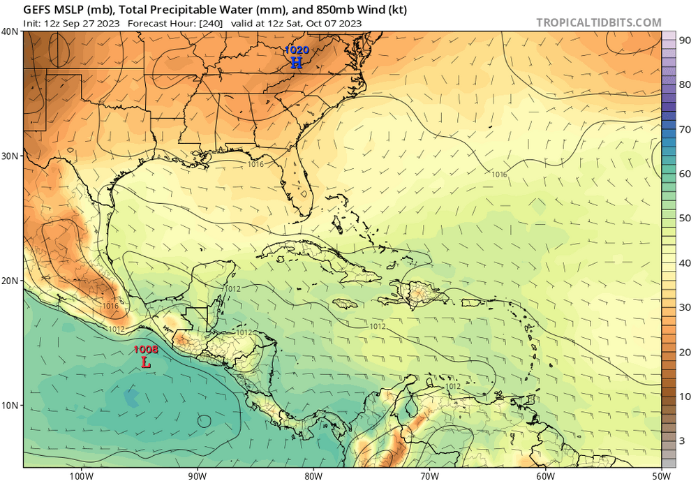
-
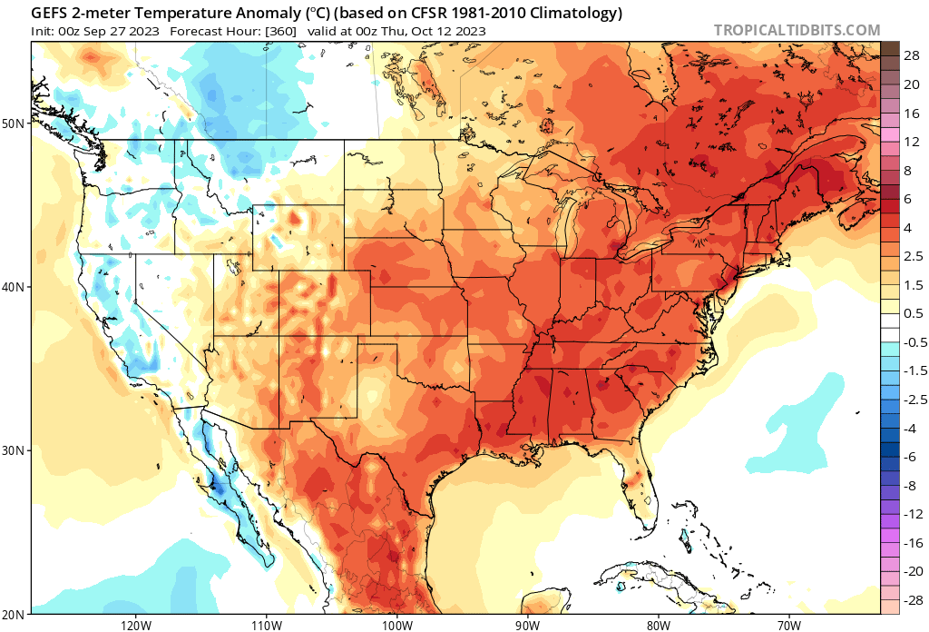
Monday was wind and thunder and power out, Tuesday looked to be dry with big storms to the E, but they made it here around 7 pm. Severe warned, but just a nice rain with a little thunder. Maybe turning the corner on the drought. Warmer than normal doesn't look to change.
-
NASCAR doesn't draw the crowds it used to at TMS, on the Wise/Denton County border. (Part of Fort Worth, even though not in Tarrant County). Still, probably >50.000 people at an outdoor sporting event. I wonder what hail would do to the race cars.
-
2023 Atlantic Hurricane season
Ed, snow and hurricane fan replied to Stormchaserchuck1's topic in Tropical Headquarters
Idalia has a decent shot at retirement. As far as the never ending CV/Atlantic MDR season, 91L, although intensity guidance seems to suggest it may not become a hurricane. SHIPS shear increases to near 30 knots in 3 days. -
Area of storms that on current trend will miss Houston metro to the E. CAPE is sufficient, a bit of backbuilding W wouldn't be surprising. And then whatever comes down this evening/tonight from the North and Central Texas SPC outlooked storms. 7 day GFS ensemble rain total for my house (and on down into STX) is just under half an inch. Hit and miss nature of recent rain suggests fire danger still exists.
-
TS Philippe & TS Rina
Ed, snow and hurricane fan replied to Windspeed's topic in Tropical Headquarters
How many depressions form E of 50W after September 21? -
2023 Atlantic Hurricane season
Ed, snow and hurricane fan replied to Stormchaserchuck1's topic in Tropical Headquarters
A day old, but I was busy. Lower Gulf pressures would rob convergence from the Caribbean, but one good cold front might fix that. I'm a little impressed CV season is still going past the Equinox. -
Does that matter in the bigger picture? Edit to Add Image in Addition to Y Cantor tweet: Its subtropical
-
40% orange.
-
Latest SHIPS has AHI of zero, not at all annular, but I see only outflow channels, not feeder bands. If it could close the eyewall on the E side it would at least look annular.
-
2023 Atlantic Hurricane season
Ed, snow and hurricane fan replied to Stormchaserchuck1's topic in Tropical Headquarters
I'm not sure the usual 'second season' in the Caribbean in October happens this year.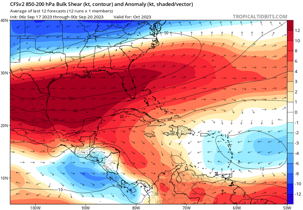
-
WPC QPF and 0Z GFS forecast show heaviest rain just offshore Carolinas to S New England. If this is impactful, I suspect it will be because of fresh water flooding.
-
2023 Atlantic Hurricane season
Ed, snow and hurricane fan replied to Stormchaserchuck1's topic in Tropical Headquarters
I like my isobars a little more circular. Longer term, Euro and ensembles and op GFS suggest a fish from NHC 7 day orange, but enough W members on GFS ensembles to suggest a NE Caribbean/Bermuda threat. Edit to Add: weaker Euro members aren't recurving although the mean at 240 hours looks like OTS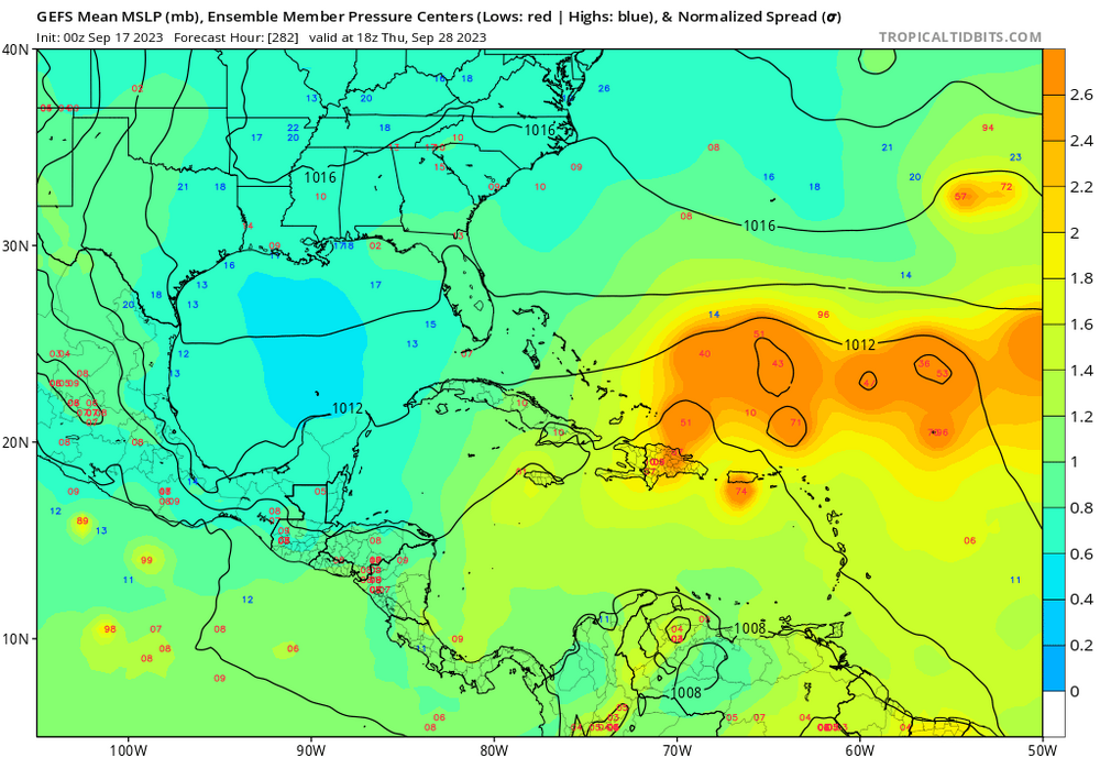
-
Getting the light stratiform rain between cells, better than no rain at all.
-
2023 Atlantic Hurricane season
Ed, snow and hurricane fan replied to Stormchaserchuck1's topic in Tropical Headquarters
30 knot storms on the ensemble aren't as interesting as the persistent (0, 6, 12Z) GFS ensembles suggesting a system that might not develop as quickly as its predecessors and pose a Cape Verde season in overtime threat to the E Caribbean (and SEUSA?) Weenies can ween for days, GFS family have seemed decent in not being too overenthusiastic, except in the SW Caribbean where it has done that since probably AVN/MRF days -
Been skunked two days in a row. Yesterday I saw the lightning and the dark rain curtain, but nothing. The line then filled in completely once past. Trying to will storms to the WNW to move E and not SE. 1.7" PW IMBY as compared to the 2" PW to the W suggests another dry day is possible.
-
2023 Atlantic Hurricane season
Ed, snow and hurricane fan replied to Stormchaserchuck1's topic in Tropical Headquarters
End of month GFS ensembles look interesting Caribbean/maybe ECUSA. Enough of a signal to show up on the means.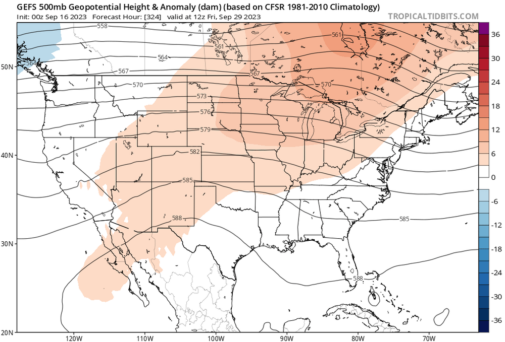
-
Lee banter thread
Ed, snow and hurricane fan replied to Santa Claus's topic in Tropical Headquarters
I feel a bit cheated. One day of RI with incredible recon (and Jova in the Pacific), then the mid-level shear and weakening. But ACE was 105 yesterday, already a near normal season in an El Nino. I thought the CSU numbers were whack, but apparently not. -
2023 Atlantic Hurricane season
Ed, snow and hurricane fan replied to Stormchaserchuck1's topic in Tropical Headquarters
The Gulf and Caribbean are staying quiet at least through the next two weeks per the GFS ensembles. Little to no activity through mid October for the Euro weeklies. Good for Florida. I don't see why the Caribbean would be so quiet, although weeklies suggesting EPAC action which would be suppressive of the Caribbean.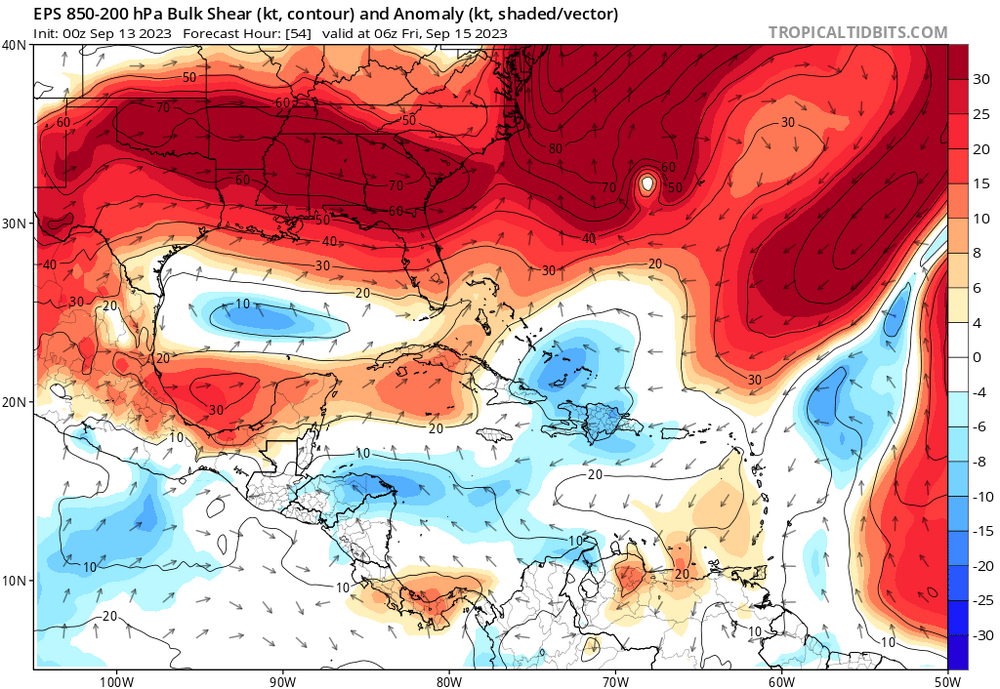
-
Only 96* in Houston and afternoon dew points dropped to 59*. And it should rain.
-
Category Five Hurricane Lee
Ed, snow and hurricane fan replied to WxWatcher007's topic in Tropical Headquarters
The Southern part of that warm area is where I would expect to see the eye with cold tops wrapping around it. The rest of it looks 'wrong' to me somehow. Like something is hindering the storm.