Ed, snow and hurricane fan
-
Posts
2,133 -
Joined
-
Last visited
Content Type
Profiles
Blogs
Forums
American Weather
Media Demo
Store
Gallery
Everything posted by Ed, snow and hurricane fan
-
 Moderate 'popcorn' showers forming along and E of the US 59/I-69 corridor. Looks to maybe get my yard later, probably misses the pine forests most susceptible to fire.
 -
Category Five Hurricane Lee
Ed, snow and hurricane fan replied to WxWatcher007's topic in Tropical Headquarters
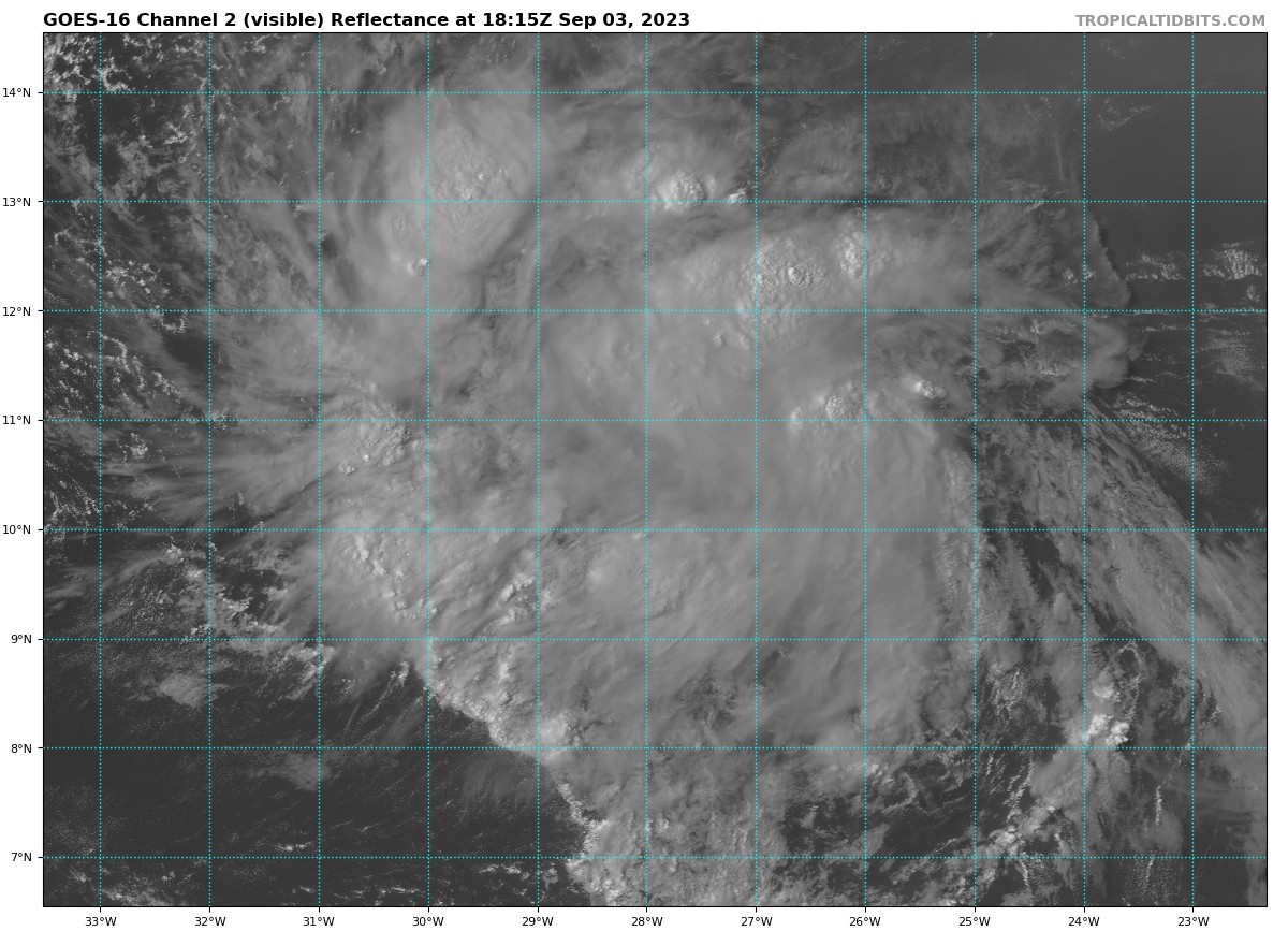
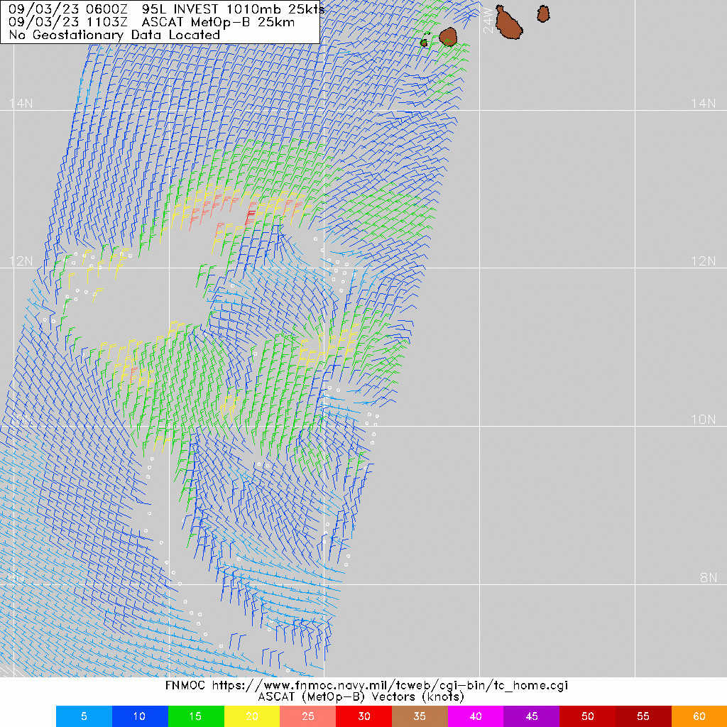
Depends on who you ask. Growing up, I always imagined 1938 happening that year, especially after Belle got me 'nerding' on hurricanes. Hurricane Ike seemed an adventure, except the following year there wasn't a beach house to go to in Galveston the next year. But now, I'm not looking forward to a week without AC and CPAP (I suddenly got kind of old), I doubt most people look forward to damaged homes, dead people, a week or more with no power. I think of 'fish' storms as nice ACE generators, and people on X/Twitter posting cool satellite animations. Speaking of, on visible loops, 95L looks close to closing a low around 11N, 33 or 34W. I am not seeing dry air caused arc clouds like I did yesterday. Outflow restricted to the E, but looking good elsewhere. -
Category Five Hurricane Lee
Ed, snow and hurricane fan replied to WxWatcher007's topic in Tropical Headquarters
6Z GFS ensembles are generally well E of the model. I see a single member with a NY/New England landfall. -
2023 Atlantic Hurricane season
Ed, snow and hurricane fan replied to Stormchaserchuck1's topic in Tropical Headquarters
The UKMET texts used to just have weak, moderate, strong and intense, not sure why they include wind and pressure when they are always low. The ensembles suggest the pattern won't change. I'd think just the changing seasons would make it change. But apparently not..thumb.png.513fe25e57f924990b4196b0528e9852.png)
-
Category Five Hurricane Lee
Ed, snow and hurricane fan replied to WxWatcher007's topic in Tropical Headquarters
Satellite suggests some dry air issues, although GFS analyzed mid level RH shows what should be a nice moisture pouch.
-
Category Five Hurricane Lee
Ed, snow and hurricane fan replied to WxWatcher007's topic in Tropical Headquarters
Welcome back. -
HGX fire weather disco expressing some concern for t-storms drifting into inland SE Texas for lightning strikes and gusty winds, and not much rain. POPs as high as 60% in Houston proper, but I doubt that, somehow. I believe August was 0.01 inches of rain for August at IAH, I know Hobby received a trace, setting a monthly record for no rain. Hi Res NAM would suggest 20% anywhere, HRRR shows a nice storm late tomorrow for Houston, but it also look no better than 20% area wide. https://www.cbsnews.com/texas/news/4000-acre-wildfire-triggers-evacuations-in-walker-county/
-
Category Five Hurricane Lee
Ed, snow and hurricane fan replied to WxWatcher007's topic in Tropical Headquarters
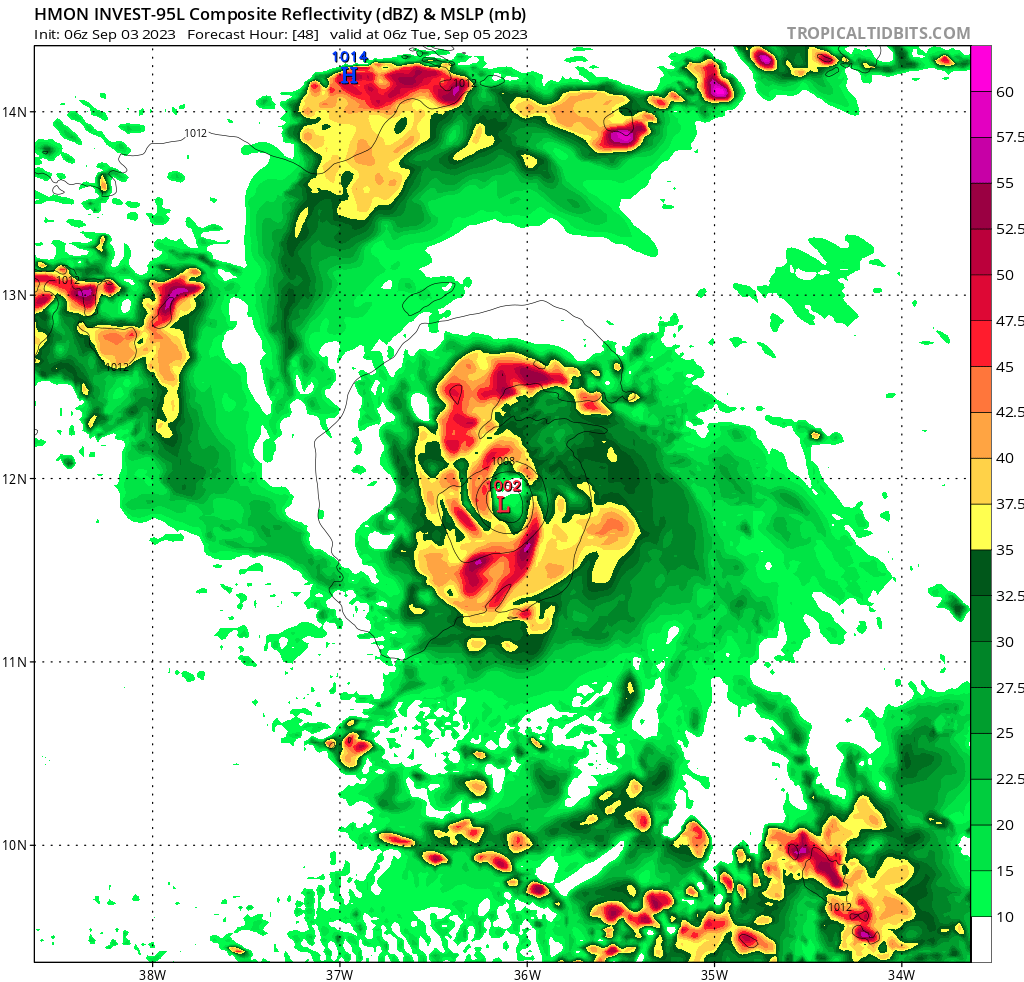
I agree with 'Da Buh's point about declaring fish storms when the modeled recurve is still days away, but I unfollowed him, he posts what seems to be intentionally bad grammar in posts where he posts pictures of cloud blobs that don't ever develop. He seems a low rent Joe Bastardi without the political posts. 95L looks to me to be more than a 40% two day development chance, judging by satellite. Even with the shear from the East. The hurricane models are mixed on developing within 2 days, HAFS A and HWRF are a bit over 2 days out, HMON and HAFS B close off an organized low inside 2 days.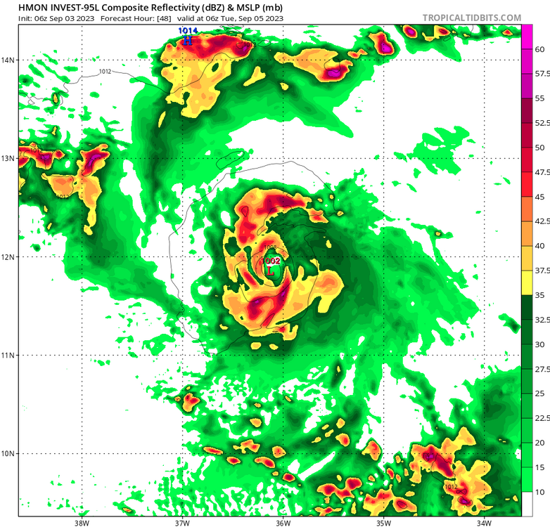
-
Category Five Hurricane Lee
Ed, snow and hurricane fan replied to WxWatcher007's topic in Tropical Headquarters
Still a long way out, but GFS and Euro ensembles look fishier today than yesterday. Still more than a few members are in the NW Caribbean. First visible, impressive looking although I can't see a closed circulation. It is probably getting close.
-
Category Five Hurricane Lee
Ed, snow and hurricane fan replied to WxWatcher007's topic in Tropical Headquarters
The Euro and GFS ensembles (and their ops) aren't that radically different in a week, really, but the difference in huge in impact. GFS looks like an E Caribbean threat, Euro only about 200 miles apart, but suggests Bermuda may the only land that keeps 95L a pure fish. And Bermuda is a small enough target it could be pure fish food. -
Category Five Hurricane Lee
Ed, snow and hurricane fan replied to WxWatcher007's topic in Tropical Headquarters
What is the difference between the A and B? -
Category Five Hurricane Lee
Ed, snow and hurricane fan replied to WxWatcher007's topic in Tropical Headquarters
36-48 hours shear drops significantly and heat content rises, although SSTs are above 28C the entire forecast on the latest SHIPS. Whether the Greater Antilles actually effects 95L, too far out in time and the land interaction may or may not affects intensity. Eyeballing mid-point of the ensembles at 174 hours, ensemble mean looks to be near or over NE Caribbean and into one of the Greater Antilles. At that time, other than 12Z being a little slower to spin up 95L, not a huge swing between 6Z and 12Z ensembles at hour 180. I do wish WxNerds ensemble page adjusted the forecast time when flipping through the runs. -
Category Five Hurricane Lee
Ed, snow and hurricane fan replied to WxWatcher007's topic in Tropical Headquarters
Gert/Idalia could weaken the ridge enough to influence this. Giving it enough latitude crossing the Atlantic making it easier for the trough offshore ECUSA to curve it so it misses the islands. Maybe. Nice original post. -
2023 Atlantic Hurricane season
Ed, snow and hurricane fan replied to Stormchaserchuck1's topic in Tropical Headquarters
GFS is into the Northern Lesser Antilles. I'm not sure what new data comes in that changes models that much in 6 hours. Over a week out, into the Caribbean vs missing the islands to the N is probably noise. It still looks like it will try to miss ECUSA, but its early. -
2023 Atlantic Hurricane season
Ed, snow and hurricane fan replied to Stormchaserchuck1's topic in Tropical Headquarters
I could be wrong, I thought systems that stayed weak were more influenced by shallow steering, following the trades, and would be less likely to curve out to sea when there was weakness to N. OTOH, looking at the Euro ensembles, there is a suggestion of stronger members being further S -
2023 Atlantic Hurricane season
Ed, snow and hurricane fan replied to Stormchaserchuck1's topic in Tropical Headquarters
Models have gotten better in 15 years, but archived 2008 NHC forecast graphics show Ike recurving as ECUSA threat, not a Gulf threat. Based on models out 5 days. This system doesn't look like a Gulf threat, the ridge that produced record heat and drought in Houston doesn't move enough to let anything get anywhere close. Looking at Euro ensembles, ECUSA aren't impossible looking at op 500 mb heights at 240 hours, generally supported in the means.. Euro individual members look fishy. Or fish is likely, but I can see some weenie possibilities. Wildly OT, but storms named Lee and drought - 2011's Lee (landfall in Louisiana, September 4) was dry on the W side, and its winds toppled drought damaged tree limbs onto power lines, starting a fire which destroyed ~1800 businesses and homes in rural Bastrop County, between Austin and Houston. -
2023 Atlantic Hurricane season
Ed, snow and hurricane fan replied to Stormchaserchuck1's topic in Tropical Headquarters
The possibility Idalia might still exist in 10 days making surf for NY/New England is interesting. -
I could be wrong but I *think* recon found N-S elliptical eye 12 km x 8 km. EDIT- I think it is 12 nm x 8 nm.
-
Fading light on the vis loop shows a big explosion over the center.
-
2023 Atlantic Hurricane season
Ed, snow and hurricane fan replied to Stormchaserchuck1's topic in Tropical Headquarters
Like a Vid-AH-li-a onion, it is a Spanish name. All the English ones have been used. Finnish has some good I names. -
107° headed for 110°, but HGX radar showing some little cells popcorning to the N of Houston, and GRK showing more in the pipeline.
-
The 12 km, obviously.
-
Mission 3 is at the top of my TT recons. I see #2 at the bottom now that I looked down the page. It doesn't take much to confuse me. Speaking of, nobody seems to think well of the NAM as a tropical model, but 30 minutes to the 18Z run. Be interesting to compared 12Z and 18Z. More interesting to compare the globals, of course.
-
I was a JB subscriber for Charley, he predicted landfall farther S than TPA area because of angle of approach and land interaction, he was correct, it seemed to happen again with Ian. If this is forecast to almost parallel the Florida coast I wouldn't be surprised if it made landfall further S than the models would have suggested. Edit to add- Euro ensemble paths a bit less oblique than prior mentioned storms, so it may not go S of models.
-
Did NOAA 9 G-IV have a problem, it looks like it turned around looking at TT

.png.fe7c52721376646eacc2186dfdfb87ee.png)