
Brian D
-
Posts
2,743 -
Joined
-
Last visited
Content Type
Profiles
Blogs
Forums
American Weather
Media Demo
Store
Gallery
Everything posted by Brian D
-
March 7 1987: A heat wave across Minnesota brings the earliest 70 degree readings on record to the Twin Cities. The record high for the day was 73, breaking the old record by 13 degrees. Shorts were common and people were turning over dirt in their gardens for planting. 1950: A snow and ice storm hits Minnesota. The heaviest ice was in northwest and west central Minnesota, especially in Norman County near Twin Valley. 52 electrical poles were down in this area with ice up to 1 ½ inches on wires. All communication lines out of Fargo were out with wind gusts estimated up to 60 mph. In order to provide temporary long distance service to and from isolated communities, short wave radio equipment was used to bridge the gaps. In Pipestone, several plate glass windows were blown in. During the snowstorm that followed later in the day, a Northwest Airlines plane crashed into three homes in Minneapolis killing all 13 on the plane and two on the ground. The left wing of the plane struck a flagpole at Ft. Snelling National Cemetery as it circled to land. For Saturday, March 7, 2026 1717 - The Great Snow, a composite of four winter storms to hit the eastern U.S. in nine days, finally came to an end. Snow depths averaged 60 inches following the storm. Up to four feet of snow fell around Boston MA, and snow drifts 25 feet high were reported around Dorchester MA. (David Ludlum) (The Weather Channel) 1932 - A severe coastal storm set barometric pressure records from Virginia to New England. Block Island RI reported a barometric pressure reading of 28.20 inches. (David Ludlum) 1987 - Forty-five cities in the north central and northeastern U.S. reported record high temperatures for the date. Huron SD hit 80 degrees, and Pickstown SD reached 81 degrees. Rochester MN and Rockford IL smashed their previous record for the date by sixteen degrees. (The National Weather Summary) 1988 - High winds along a sharp cold front ushered snow and arctic cold into the Central Rocky Mountain Region and the Northern Plains. Snowfall totals in Utah ranged up to sixteen inches at Brighton. Winds gusted to 66 mph at Rapid City SD. (The National Weather Summary) (Storm Data) 1989 - Blustery northwest winds ushered arctic cold into eastern U.S. Burlington VT reported a record low of 14 degrees below zero. Snow and ice over the Carolinas replaced the 80 degree weather of the previous day. High winds and heavy surf caused five million dollars damage along the North Carolina coast. (The National Weather Summary) (Storm Data) 1990 - A major ice storm left much of Iowa under a thick coat of ice. It was the worst ice storm in at least twenty-five years for Iowa, perhaps the worst of the century. Up to two inches of ice coated much of western and central Iowa, with three inches reported in Crawford County and Carroll County. As much as five inches of ice was reported on some electrical lines. The ice downed 78 towers in a 17-mile stretch of a high voltage feeder near Boone costing three electric utilities fifteen million dollars. Damage to trees was incredible, and clean-up costs alone ran into the millions. Total damage from the storm was more than fifty million dollars. (Storm Data) March 8 2004: A vigorous Alberta Clipper brings an intense snow burst across the Twin Cities from 9:30 am to noon. 2.5 inches fell, with most of it accumulating in an hour at the State Climatology Office on the University of Minnesota St. Paul Campus. Numerous crashes were reported across the metro area with I-94 closed at Highway 280 and also at White Bear Avenue. In a rare scene, television programming was interrupted to report on the snow situation. By early afternoon most of the snow had moved into Wisconsin and road conditions rapidly improved. 1892: A blizzard hits Minnesota, with 70 mph winds recorded at Easton. Duluth was hit especially hard with 60 mph winds causing large drifts. Residents were able to walk out of their second story windows. 1717 - On Fishers Island in Long Island Sound, 1200 sheep were discovered to have been buried under a snow drift for four weeks. When finally uncovered, one hundred sheep were still alive. (The Weather Channel) 1909 - The town of Brinkley AR was struck by a tornado which killed 49 persons and caused 600,000 dollars damage. The tornado, which was two-thirds of a mile in width, destroyed 860 buildings. Entire families were killed as houses were completely swept away by the tornado. Tornadoes killed 64 persons and injured 671 others in Dallas and Monroe counties during the Arkansas tornado outbreak. (David Ludlum) 1984 - A freak thunder snowstorm produced high winds, vivid lightning, and up to seven inches of snow in the northern suburbs of Washington D.C. (Sandra and TI Richard Sanders - 1987) 1987 - Thirty-two cities in the eastern U.S. reported new record high temperatures for the date, including Madison WI with a reading of 71 degrees. Afternoon highs of 68 degrees at Houghton Lake MI and 72 degrees at Flint MI smashed their previous records for the date by fourteen degrees. (The National Weather Summary) 1988 - A cold front brought wintry weather to the north central U.S. Snowfall totals in northwestern Minnesota ranged up to eight inches at Roseau and Hallock. Winds in South Dakota gusted to 61 mph at Brookings. (The National Weather Summary) (Storm Data) 1989 - While arctic cold gripped the northeastern U.S., unseasonably warm weather prevailed across the southwestern states. Albany NY reported a record low of 2 degrees below zero. Tucson AZ reported a record high of 90 degrees. (The National Weather Summary) 1990 - Late afternoon thunderstorms produced severe weather in east central Iowa and west central Illinois. Thunderstorms spawned a tornado south of Augusta IL which traveled 42 miles to Marbleton. Golf ball size hail was reported at Peoria IL and near Vermont IL. (The National Weather Summary) (Storm Data) 2004 - The California coast warms up. San Francisco broke a 112-year record by reaching 82 degrees. Los Angeles soared to 93 degrees. 2005 - A line of strong to severe thunderstorms affected the eastern portions of North and South Carolina, with wind damage and a few tornadoes reported. Winds gusted over 70 MPH with some of the stronger storms.
-
Lost my net last Friday aftrn. Outage in my area with Frontier. Finally came back during the overnight last night. Picked up 1.2" of snow last night as well.
-
Was able to get a measure of ice at 1/16" with the trees having a little more. Ugly stuff but picturesque. Lost power for a little more than a 1/2 hr, too, just a bit ago.
-
Freezing fog/mist since yesterday. Trees coated pretty good with surfaces having a thin coat. Temps are to rise into the upper 30's today, but we'll see. Hopefully that will be the case before any rain falls. Power blinking for a short time early this morning.
-
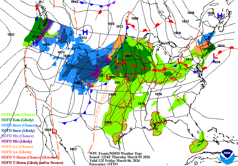
March 6 1836: Unusual cold for March lasts for 12 days at Ft. Snelling. During this time, 7 nights were in the double-digits below zero. For Friday, March 6, 2026 1872 - A cold wave hit the East coast sending the mercury plunging to 8 degrees below zero at Boston. It was the most severe March cold wave in modern history. (David Ludlum) 1900 - A chinook wind blowing down the slopes of the Rockies through Havre MT raised the temperature 31 degrees in just three minutes. (The Weather Channel) 1954 - Florida received its greatest modern-day snowfall of record, with 4.0 inches at the Milton Experimental Station. Pensacola FL equalled their 24-hour record with 2.1 inches of snow. (The Weather Channel) 1987 - Twenty-eight cities in the north central U.S. reported record high temperatures for the date. Pickstown SD was the hot spot in the nation with a reading of 83 degrees. The high of 71 at Saint Cloud MN smashed their previous record by 21 degrees. (The National Weather Summary) 1988 - Wintry weather developed in the Rockies and the Plateau Region as arctic air swept in from the northwest. Blizzard conditions in southeast Idaho claimed the lives of two teenagers. Thunderstorms developed in Utah and Idaho. (The National Weather Summary) (Storm Data) 1989 - A winter storm in the south central U.S. left parts of Missouri and Arkansas buried under more than a foot of snow. Heavier snowfall totals in Missouri included 14 inches at Springfield and 16 inches at Lebanon. Totals in Benton County AR ranged up to 14 inches. (The National Weather Summary) (Storm Data) 1990 - Colorado's strongest winter storm of the season moved northeastward across the state producing 50 inches of snow at Echo Lake, 46.5 inches on Buckhorn Mountain, and 46 inches near the top of Coal Canyon. Snow fell at the rate of several inches per hour during the height of the storm, while winds gusted above 50 mph. Several hundred rush hour commuters, including the state governor, were stranded in blizzard conditions along Highway 36 between Denver and Boulder. Drifts up to twelve feet high had to be cleared southeast of Boulder. (The National Weather Summary) (Storm Data)
-
Decent call. Timing off tho. A little aggressive bringing HP into the sub, but storm potential is unfolding.

-
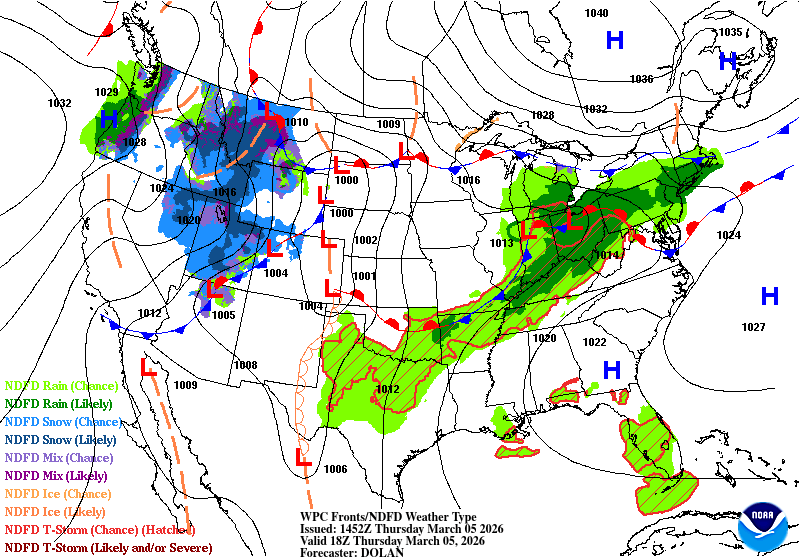
March 5 1966: A powerful blizzard finally ends in the Upper Midwest. Some wind gusts from the storm topped 100 mph. For Thursday, March 5, 2026 1960 - Eastern Massachusetts greatest March snowstorm of record began to abate. The storm produced record 24 hour snowfall totals of 27.2 inches at Blue Hill Observatory, 17.7 inches at Worcester, and 16.6 inches at Boston. Winds gusted to 70 mph. (3rd-5th) (The Weather Channel) 1962 - A tremendous storm raged along the Atlantic coast. The great Atlantic storm caused more than 200 million dollars property damage from Florida to New England. Winds along the Middle Atlantic Coast reached 70 mph raising forty foot waves, and as much as 33 inches of snow blanketed the mountains of Virginia. The Virginia shoreline was rearranged by historic tidal flooding caused by the combination of the long stretch of strong onshore winds and the Spring Tides. (David Ludlum) 1987 - A storm in the western U.S. produced heavy rain and high winds in California. Up to six inches of rain soaked the San Francisco Bay area in 24 hours, and winds gusted to 100 mph at the Wheeler Ridge Pumping Plant near the Tehachapi Mountains. (The National Weather Summary) (Storm Data) 1988 - While snow blanketed eastern Kansas and northern Oklahoma, eight cities in North Dakota reported new record high temperatures for the date. The afternoon high of 61 degrees at Bismarck ND was 27 degrees warmer than that at Chanute KS. (The National Weather Summary) (Storm Data) 1989 - Thunderstorms produced severe weather in the southeastern U.S. A strong (F-2) tornado killed one person and injured six others in Heard County GA. A strong (F-3) tornado injured 23 persons and caused more than five million dollars damage around Grantville GA. (The National Weather Summary) (Storm Data) 1990 - Thunderstorms over eastern Colorado, developing ahead of a major storm system, produced up to three inches of small hail around Colorado Springs in the late morning and early afternoon. Strong thunderstorms swept through southeastern sections of the Denver area during the evening hours. These strong thunderstorms also produced up to three inches of small hail, along with wind gusts to 50 mph, and as much as 2.4 inches of rain. (The National Weather Summary) (Storm Data)
-
Freezing fog last night. Looks like 0.01-0.02" of ice on the the trees. Chance of frz rn tomorrow.
-
Ice has rebounded with the colder wx this past weekend. Doesn't take long this time of year, with water temps near freezing, to make ice.
-
March 4 1935: An extremely damaging ice storm hits Duluth. At the time it was called 'The worst ice storm in Duluth’s history'. The storm began with freezing rain and wet snow falling at the Duluth Weather Bureau at 7th Ave West and 8th Street at 10pm on March 3rd. The temperature was 26 degrees. By the morning of the 4th, the snow stopped but the freezing rain continued. The lights started going out in Duluth by 6pm on the 4th due to power lines breaking. By the morning of the 5th, Duluth was virtually isolated from the outside world except for shortwave radio. A local ham radio operator sent the Duluth National Weather Service reports: Four streetcars had to be abandoned in the storm, three of them in the western part of the city. A heavy salt mixture and pickaxes were used to try to free the stuck streetcars. A one-mile stretch of telephone poles along Thompson’s Hill was broken off as if they were toothpicks due to the ice. For Wednesday, March 4, 2026 1909 - Though fair weather was forecast, President Taft was inaugurated amidst a furious storm. About ten inches of wet snow disrupted travel and communications. The storm drew much criticism against the U.S. Weather Bureau. (David Ludlum) 1953 - Snow was reported on the island of Oahu in Hawaii. (The Weather Channel) 1966 - A severe blizzard raged across Minnesota and North Dakota. The blizzard lasted four days producing up to 35 inches of snow, and wind gusting to 100 mph produced snow drifts 30 to 40 feet high. Bismarck ND reported zero visibility for 11 hours. Traffic was paralyzed for three days. (2nd-5th) (The Weather Channel) 1987 - Rain and high winds prevailed in the northwestern U.S. A wind gust to 69 mph at Klamath Falls OR was their highest in 25 years, and winds at the Ashland Ranger Station in the Siskiyou Mountains of northern California reached 85 mph. (The National Weather Summary) (Storm Data) 1988 - Snow and freezing rain made travel hazardous in Ohio and Indiana. A six car pile-up resulted near Columbus OH, with seven injuries reported. Up to two inches of ice glazed central Indiana. Up to ten inches of snow blanketed northern Ohio. (The National Weather Summary) (Storm Data) 1989 - Thunderstorms produced severe weather in the Lower Mississippi Valley. A strong (F-3) tornado injured five persons near Brownsville MS, and killed seven cows and two hogs in one pasture. Thunderstorm winds gusted to 90 mph at Canton MS. (The National Weather Summary) (Storm Data) 1990 - A Pacific cold front working its way across the western U.S. produced heavy snow over parts of Idaho, Nevada and Utah. Up to eleven inches of snow blanketed the valleys of northwest Utah, while 12 to 25 inches fell across the mountains of northern Utah. Up to six inches of snow blanketed the valleys of east central Nevada, while more than a foot of snow was reported in the high elevations. In Idaho, 6 to 8 inches of snow was reported around Aberdeen and American Falls. (The National Weather Summary) (Storm Data) 2004 - An F0 tornado 2 miles north of Muldrow breaks a record stretch of days without a reported tornado, 292 days. 2008 - Only two days after reaching 78 degrees, St. Louis receives nearly a foot of snow in seven hours, the biggest snowstorm in 15 years.
-
Big concern for me on Friday is potential for Frz Rn. This past weekends bitter wx has allowed the western half of the Lake to become ice covered again. Winds are mellow until Thurs, when an E/NE wind starts to kick up. With icy waters, and warmer air aloft, the shore could see a decent icing, depending on precip amounts. Temps will be borderline.
-
March 3 1977: A snowstorm results in over 400 school closings in Minnesota and Wisconsin. For Tuesday, March 3, 2026 1966 - A tornado hit Jackson, MS, killing 54 persons. (David Ludlum) 1980 - A coastal storm produced 25 inches of snow at Elizabeth City, NC, and 30 inches at Cape Hatteras NC. At Miami FL the mercury dipped to 32 degrees. (Sandra and TI Richard Sanders - 1987) 1983 - The last of a series of storms to strike the California coast finally came to an end. Waves fifteen to twenty feet high pounded the coast for two days, and in a four day period up to 18 inches of rain drenched the Los Angeles and Santa Barbara area. On the morning of the first, thunderstorms spawned two tornadoes which moved through the Los Angeles area. (Storm Data) 1987 - A storm brought heavy rain and gale force winds to Washington and Oregon. Quillayute WA received 2.67 inches of rain in 24 hours, and winds gusted to 60 mph at Astoria OR. (The National Weather Summary) (Storm Data) 1988 - A small but intense low pressure system roared across west central Mississippi at 90 mph early in the morning. A tornado in southern Mississippi picked up an automobile, carried it 150 feet, and tossed it through the brick wall of an unoccupied retirement home. (The National Weather Summary) (Storm Data) 1989 - Wintry weather prevailed from the southern Rockies to the Upper Great Lakes. Neguanee MI received 19 inches of snow, and up to 24 inches of snow blanketed Colorado. Blizzard conditions were reported in Minnesota. (The National Weather Summary) (Storm Data) 1990 - An upper level weather disturbance produced snow in the Colorado Rockies, with eight inches reported at Winter Park, and a storm moving off the Pacific Ocean began to spread rain and snow across the western U.S. March continued to start off like a lamb elsewhere around the country. (The National Weather Summary) (Storm Data) 2003 - It was a day of temperature extremes. Miami reached a high temperature of 90 degrees, the earliest observed 90 degree temperature since March 5, 1964. Meanwhile Marquette, MI, dropped to 30 degrees below zero, the lowest temperature ever recorded in the city in March.
-
March 2 1913: A record low of 24 degrees below zero is set at the St. Cloud Regional Airport. For Monday, March 2, 2026 1846 - A great storm hit Virginia and the Carolinas. The storm caused half a million dollars damage, and in North Carolina drowned fifty families and a thousand cattle on Notts Island. (David Ludlum) 1927 - Raleigh, NC, was buried under 17.8 inches of snow in 24 hours, a record for that location. Nashville NC received 31 inches of snow. The average snow depth in the state of Carolina was fourteen inches. (The Weather Channel) 1975 - The governor's Tornado in Atlanta did considerable damage to the governor's mansion and surrounding areas resulting in three deaths and 56.5 million dollars damage. (The Weather Channel) 1985 - A massive winter storm struck the Northern Plains Region. The storm produced up to 33 inches of snow in northeastern South Dakota, at Summit and at Milbank, and also produced high winds which whipped the heavy snow into drifts twenty feet high. (Storm Data) 1987 - A storm in the northeastern U.S. produced heavy snow in Maine, with 16 inches reported at West Grand Lake and Guilford. (The National Weather Summary) (Storm Data) 1988 - Thunderstorms produced severe weather in the south central U.S. A tornado at Baton Rouge LA injured two persons, and another tornado caused five million dollars damage at the airport in Lafayette LA. (The National Weather Summary) (Storm Data) 1989 - Snow and high winds plagued the western U.S. Up to 16 inches of snow was reported south of Seattle WA, and more than two feet of snow blanketed the Sierra Nevada Range of California. Winds gusted to 89 mph at Hidden Peak UT, and reached 92 mph at Peavine CA. (The National Weather Summary) (Storm Data) 1990 - Mild weather continued across the northern tier of states. Highs of 52 degrees at Saint Johnsbury VT, 63 degrees at Olympia WA, and 64 degrees at Seattle WA were records for the date. (The National Weather Summary)
-
10's (some sd's) this morning. Pleasant wx with seasonably warm to warm conditions on tap. -Rn to -sn late week possible. Loving the longer days, and DST starts next weekend.
-
March 1 1966: The Blizzard of '66 hits Minnesota and lasts 4 days. Aitkin received 23 inches of snow. The snow depth at International Falls reached a record 37 inches by the end of the storm. For Sunday, March 1, 2026 1910 - The deadliest avalanche of record in the U.S. thundered down the mountains near Wellington Station WA sweeping three huge locomotive train engines and some passenger cars, snowbound on the grade leading to Stevens Pass, over the side and into a canyon, and burying them under tons of snow. The avalanche claimed the lives of more than 100 people. The station house at Wellington was also swept away. (The Weather Channel) 1914 - High winds and heavy snow crippled New Jersey and New York State. Two feet of snow were reported at Ashbury Park, and at New York City the barometric pressure dropped to a record 28.38 inches. The storm caused complete disruption of electric power in New Jersey. (David Ludlum) 1980 - Norfolk, VA, received 13.7 inches of snow to push their season total to a record 41.9 inches exceeding their previous record by more than four inches. (David Ludlum) 1980 - An unusually large Florida tornado, 500 yards in width at times, killed one person and caused six million dollars damage near Fort Lauderdale. (The Weather Channel) 1983 - A ferocious storm battered the Pacific coast. The storm produced heavy rain and gale force winds resulting in flooding and beach erosion, and in the mountains produced up to seven feet of snow in five days. (The Weather Channel) 1987 - A storm crossing the Great Lakes Region produced heavy snow and gale force winds from Wisconsin to northern New England, with eight inches of snow reported at Ironwood MI. (The National Weather Summary) 1988 - Thunderstorms produced large hail and damaging winds in north central Texas. Baseball size hail was reported at Lake Kickapoo. Hail fell continuously for thirty minutes in the Iowa Park area of Wichita Falls. (The National Weather Summary) (Storm Data) 1989 - March came in like a lion, with snow and high winds, in the northwestern U.S. Winds gusted to 86 mph in the Rosario Strait of western Washington State. (The National Weather Summary) (Storm Data) 1990 - A series of low pressure systems moving out of the Gulf of Alaska spread high winds and heavy snow across western Alaska. Winds in the Anchorage area gusted to 69 mph at Glen Alps, and Talkeetna was buried under three feet of snow in two days. Valdez received 21.4 inches of snow, raising their total for the winter season to 482.4 inches. (The National Weather Summary) (Storm Data) 2006 - Dallas/Forth Worth Airport breaks a 107-year-old North Texas temperature record after reaching 93 degrees. Mineral Wells reached 97, Wichita Falls 96 and Fort Worth Meacham Airport 90. 2011 - Snowfall across Idaho broke numerous accumulation records. Pierce received 15 inches, Powell 14.5 inches, Potlatch 12 inches and Kellogg and Plummer 7 inches. The same storm created high winds across the Pacific Northwest. A weather station at 10,000 feet on Mount Rainier measures a wind gust of 137 MPH with a sustained 1-minute wind reading of 112 MPH.
-
Significant cold a.m. across NE MN with -sd's near the shore to -20's inland with -31 at Seagull Lake up on the border.
-
-sd's (some -10's) around the area this morning. Cold day in the teens with another cold one to start March tomorrow.
-
February 28 1981: Ice is out on Lake Minnetonka. Boats are enjoying the early thaw. For Saturday, February 28, 2026 1900 - A massive storm spread record snows from Kansas to New York State. Snowfall totals ranged up to 17.5 inches at Springfield IL and 43 inches at Rochester NY, with up to 60 inches in the Adirondack Mountains of New York State. (David Ludlum) 1952 - An intense storm brought coastal sections of southeastern Massachusetts to a halt, stranding 3000 motorists on Lower Cape, and leaving ten thousand homes on the Cape without electricity. Winds gusting to 72 mph created mountainous snowdrifts of the 18 inches of snow which buried Nantucket and Hyannis. A barometric pressure reading of 29.02 inches was reported at the center of the storm. (The Weather Channel) 1987 - A powerful storm produced severe thunderstorms in Louisiana and Mississippi early in the day. About mid morning a monstrous tornado touched down near Moselle MS and grew to a width of two miles as it passed near Laurel MS. The tornado traveled a distance of 40 miles killing six persons, injuring 350 others, and causing 28.5 million dollars damage. The tornado swept homes right off their foundations, and tossed eighteen wheel trucks about like toys. Strong straight line winds associated with the powerful storm system gusted to 70 mph at Jonesboro AR and Carbondale IL. (The National Weather Summary) (Storm Data) 1988 - Thunderstorms in California produced severe weather during the early morning hours. Strong thunderstorm winds, gusting to 74 mph, downed trees in the Sacramento area. Unseasonably mild weather prevailed in the northwestern U.S. The afternoon high of 71 degrees at Portland OR was a February record. (The National Weather Summary) (Storm Data) 1989 - Thunderstorms in the southeast corner of the nation produced winds gusts to 58 mph at Fort Lauderdale FL, and a total of seven inches of rain. Heavy snow whitened parts of the Northern Plateau and the Northern Rockies, with ten inches reported at Marion MT. (The National Weather Summary) (Storm Data) 1990 - Showers and thunderstorms over the Southern Plains Region capped a record wet February for parts of Oklahoma. Totals for the month ranged up to 9.11 inches at McCurtain, with 4.63 inches reported at Oklahoma City. Snow and sleet fell across northern Oklahoma, with four inches reported at Freedom and Jefferson. Snow also spread across southern Kansas into Missouri and Arkansas, with six inches of snow reported at Harrison AR. In Alaska, February temperatures at Nome averaged 21 degrees below normal, ranging from -38 degrees to 29 degrees during the month. (The National Weather Summary) (Storm Data) 2012 - The first confirmed February tornado in Nebraska state history struck Lincoln and Logan Counties shortly after 4PM. The EF-0 tornado was on the ground intermittently for up to six minutes and traveled 3 miles before dissipating in southwest Logan County. The path of the tornado was over open rangeland and cropland where limited damage occurred. Patches of snow were still on the ground at the time. (NWS North Platte)
-
Typical April for me
-
No Chance hole curse is a bitch. Hopefully some good storms help you out. You need it.
-
Roger that, but a robust snowpack will greatly help up my way, as the snow melts into the ground slower with less runoff, unless hvy rns hit. A better help for the abnormally dry conditions here, and wells don't go dry, or at least not too low. You end up with more sediments then.
-
Front making its way thru with temps on a steady decline this aftrn with winds 20-30 G 40+. Looks like temps maxed around the low 50's along the shore with mid-upper 40's inland midday.
-

Winter 2025-26 Medium/Long Range Discussion
Brian D replied to michsnowfreak's topic in Lakes/Ohio Valley
Yeah, for me it's more like mid-Nov thru mid-March give or take a week or 2. -
Just thought I'd put this up. Hunga Tonga's massive seawater injection has been hangin tough in the stratosphere. Latest looks like that may be coming to an end this year, tho. We'll see how it progresses.
-
The next couple weeks could be interesting up my way. Most of which comes in the 2nd week of March.
