Brian D
-
Posts
3,110 -
Joined
-
Last visited
Content Type
Profiles
Blogs
Forums
American Weather
Media Demo
Store
Gallery
Everything posted by Brian D
-
DLH May avg temp 49.8 (-2.2), and precip 1.27" (-2.10"). Did a little better with precip up the shore here in TH with 1.86" (-1.44") with an avg temp 46.3 (-2.1).
-
Decent chance for rain coming later this week. Lets hope for a better month in that regard.
-
May 31 1934: Extreme heat impacts the Twin Cities, with highs of 107 in St. Paul and 106 in Minneapolis. Rush City reached 110. Numerous cases of heat ailments affect people and livestock. 1932: A heat wave hits southern Minnesota, with highs of 108 at Campbell, Fairmont, Faribault, and New Ulm. ^Note: Very odd wx for the time^ For Sunday, May 31, 2026 1889 - The Johnstown disaster occurred, the worst flood tragedy in U.S. history. Heavy rains collapsed the South Fork Dam sending a thirty foot wall of water rushing down the already flooded Conemaugh Valley. The wall of water, traveling as fast as twenty-two feet per second, swept away all structures, objects and people. 2100 persons perished in the flood. (David Ludlum) 1941 - Thunderstorms deluged Burlington KS with 12.59 inches of rain to establish a 24 hour rainfall record for the state. (The Weather Channel) 1985 - Severe thunderstorms spawned forty-one tornadoes across the Lower Great Lakes Region and southeastern Ontario which killed 74 persons. (Storm Data) 1987 - Thunderstorms in New England produced wind gusts up to 90 mph at Worcester, MA, and Northboro, MA, and hail an inch and a half in diameter at Williston, VT. Unseasonably hot weather prevailed in the northeastern U.S. The afternoon high of 94 degrees at Portland, ME, was a record for the month of May. (Storm Data) (The National Weather Summary) 1988 - Hot and humid weather prevailed in the eastern U.S. Thirteen cities reported record high temperatures for the date. Cape Hatteras, NC, reported their first ninety degree day in May in 115 years of records. "Dust buster" thunderstorms in northwest Texas drenched Amarillo with more than three inches of rain. (The National Weather Summary) 1989 - Thunderstorms produced severe weather and torrential rains in northern Indiana, northern Ohio and southern Lower Michigan. Saint John IND was drenched with four inches of rain in two hours, and Woodland MI was deluged with two inches in twenty minutes. Pittsburgh PA reported a record 6.55 inches of rain for the month of May, with measurable rain reported on twenty-five days during the month. (The National Weather Summary) 1990 - Afternoon and evening thunderstorms developing along a warm front produced severe weather from northwest Texas to southeastern Louisiana. The thunderstorms spawned sixteen tornadoes, including thirteen in northwest Texas. One tornado hit the town of Spearman, TX, causing more than a million dollars damage, and seven other tornadoes were reported within twenty-five miles of Spearman. Thunderstorms over northwest Texas also produced baseball size hail at Monahans, and wind gusts to 80 mph at Paducah. (The National Weather Summary) (Storm Data)
-
That reminds me, my grandfather started his in a grow room as well in the basement of their home. It was a room off to the side of the boiler room, so it stayed warm in there. Florescent lights hanging low over the flats. My grandparents were living in E Duluth (Lester Park) at that time (70's). They had a large lawn, so plenty of room to have a big garden. Mid 30's-40's across NE MN this morning. Near critical fire wx today with very low humidity inland. Makes for a larger spread in the diurnal range.
-
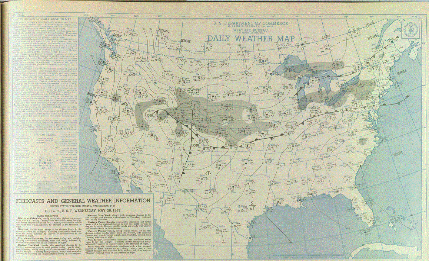
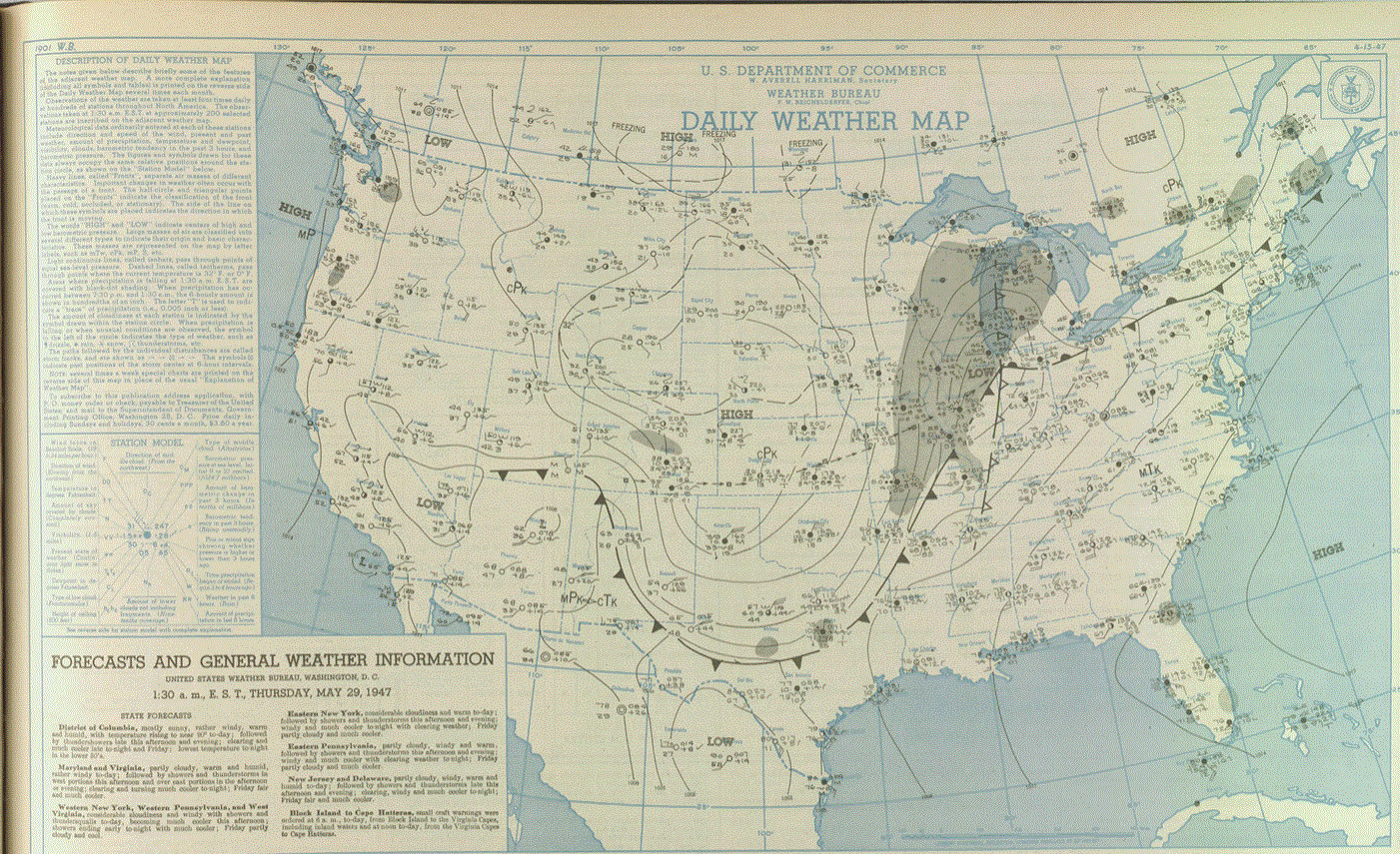
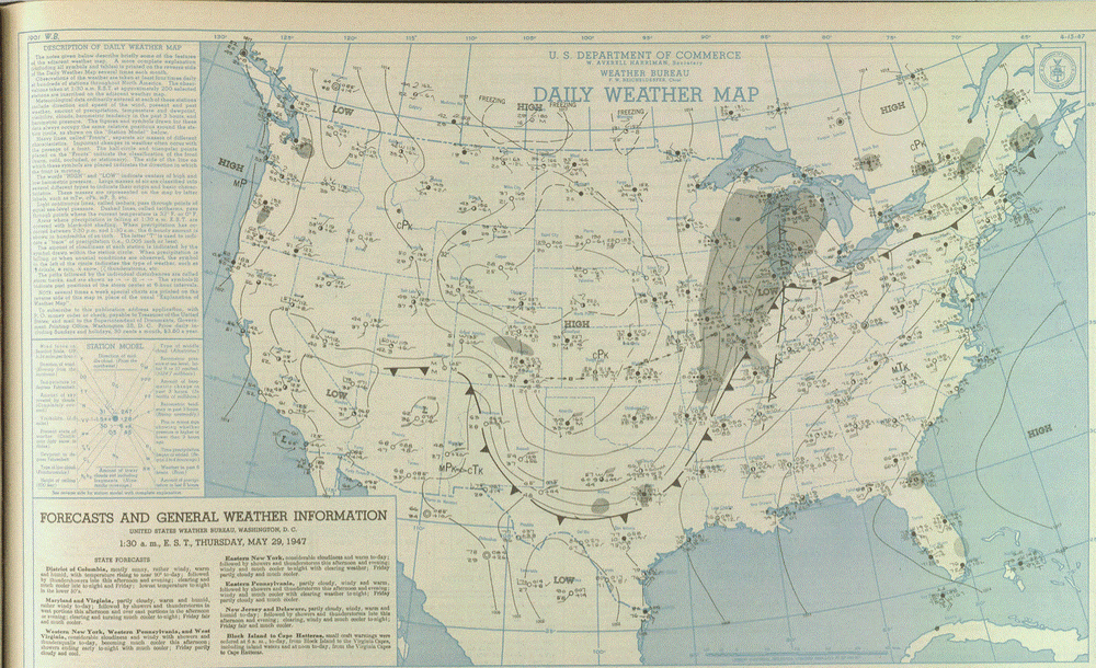
Here's the maps from May 28-29, 1947. CO low moved E along a boundary as HP from CAN pushed S into the Plains.
-
Really don't worry about frost in town now. Getting a couple flats of annuals delivered Monday. Plants won't do well until we get warmer nights in town. Then they take off. Inland areas still under a frost risk, tho. Many avid gardeners will use starter greenhouses, then plant sometime in early June. In the end, frost is always a risk up our way at any time during the summer away from the Lake. Just the way it is at higher lats.
-
Stiff Lake breeze today. Highs around 60 here in town expected. After the heat yesterday, this will feel chilly.
-
May 30 1998: A devastating line of storms hits east central Minnesota. 100 mph winds rip through Scott and Dakota County. Over 500 homes are damaged in Washington County. 15,000 trees are lost in the Twin Cities metro area, and 500,000 people lose power in Minneapolis. 1985: A tornado hits Lakefield, and the Twin Cities report 67 mph winds. For Saturday, May 30, 2026 1879 - A major outbreak of severe weather occurred in Kansas and western Missouri. In Kansas, tornadoes killed eighteen persons at Delphos, and thirty persons at Irving. Two tornadoes struck the town of Irving within a few minutes time virtually wiping the small Kansas community off the map. The second tornado was perhaps two miles wide, and exhibited multiple vortices. (David Ludlum) (The Weather Channel) 1948 - A railroad bed acting as a dam gave way during a flood along the Columbia River destroying the town of Vanport, OR. The nearly 19,000 residents escaped with little more than the clothes on their backs. (David Ludlum) 1948 - Twenty carloads of glass were needed in Denver, CO, to replace that destroyed by a severe hailstorm. (The Weather Channel) 1987 - Unseasonably warm weather prevailed across the eastern U.S. Eighteen cities, from Virginia to Ohio and Michigan, reported record high temperatures for the date. Afternoon highs of 97 degrees at Baltimore, MD, and Washington, DC, and 98 degrees at Newark, NJ, were records for the date. (The National Weather Summary) 1988 - Memorial Day heralded heavy snow in some of the mountains and higher passes of Wyoming, closing roads in Yellowstone Park. McDonald Pass, MT, was blanketed with eight inches of snow, while the temperature at Miles City, MT, soared to 94 degrees. A "supercell" thunderstorm in west Texas produced baseball size hail in Bailey and Lamb counties, and up to five inches of rain in less than an hour. (The National Weather Summary) (Storm Data) 1989 - Thunderstorms produced severe weather from the Upper Mississippi Valley to the Upper Ohio Valley during the day. A powerful (F-4) tornado injured three persons and caused a million dollars damage at New Providence, IA. Baseball size hail was reported at Blue Earth, MN. (The National Weather Summary) (Storm Data) 1990 - Thunderstorms developing along a warm front spawned fourteen tornadoes in northeastern Texas during the late afternoon and evening hours. The thunderstorms also produced baseball size hail near Marshall, wind gusts to 77 mph at Commerce, and up to five inches of rain. Thunderstorms over southwestern Kansas produced up to six inches of rain. (The National Weather Summary) (Storm Data)
-
Mid 80's here in town today. She was a warm one. Lake breeze kicked in around 6pm, and temps dropped like rock to the 50's in 20 mins. Felt good 2 gson's, 2 gnephew's, and 1 gneice graduated from THHS tonight. Grad parties start next weekend
-
May 29 1949: An intense downpour dumps over 7 inches of rain at Thief River Falls. 1947: Extremely late season snow falls in southern Minnesota, northern Iowa, and southern Wisconsin. Worthington, MN picks up an inch, while some places in southern Wisconsin receive up to 6 inches. For Friday, May 29, 2026 1951 - A massive hailstorm, from Wallace to Kearney County in Kansas, caused six million dollars damage to crops. (David Ludlum) 1953 - A tornado, 600 yards wide at times, killed two persons on its 20 mile path from southwest of Fort Rice ND into Emmons County. Nearly every building in Fort Rice was damaged. The Catholic church was leveled, with some pews jammed four feet into the ground. (The Weather Channel) 1987 - Thunderstorms in West Texas produced softball size hail at Lamesa, and hail up to twelve inches deep east of Dimmitt. Thunderstorms also spawned seven tornadoes in West Texas, including one which injured three persons at Wolfforth. Thunderstorms deluged the Texas Hill Country with up to eleven inches of rain. Severe flooding along the Medino, Hondo, Seco, Sabinal and Frio rivers caused more than fifty million dollars damage. (Storm Data) (The National Weather Summary) 1988 - A powerful cold front brought snow and high winds to parts of the western U.S. Austin, NV, was blanketed with ten inches of snow, and winds gusted to 75 mph at the Mojave Airport in California. Strong southerly winds and unseasonably warm weather prevailed in the north central U.S. Glasgow, MT, equaled their record for the month of May with a high of 102 degrees. (Storm Data) (The National Weather Summary) 1989 - Wintry weather gripped parts of the northwestern U.S. for the second day in a row. Great Falls, MT, was blanketed with 12 inches of snow, which pushed their total for the winter season to a record 117.4 inches. Six inches of snow whitened the Cascade Mountains of Oregon. (The National Weather Summary) (Storm Data) 1990 - Afternoon and evening thunderstorms produced severe weather from north central Colorado to the northern half of Texas. Severe thunderstorms spawned four tornadoes, and there were seventy reports of large hail or damaging winds. Midday thunderstorms produced wind gusts to 90 mph at Hobart, OK, and produced up to three and a half inches of rain in eastern Colorado in four hours. (The National Weather Summary) (Storm Data)
-
Yah know, warmer is suppose to be pretty normal now, right? So when it does get cooler, especially widespread, isn't that an oddity now? And are not oddities much more interesting? You would think the folks would be more impressed by those oddities than the normal stuff. What an odd bunch. I like wx, I enjoy it all! (Well almost all. Too hot/cold is bothersome).
-
That's a large field. I'd plant wild flowers/shrubs too, and keep part lawn. Women love manicured lawns with beautiful gardens in the mix. As a landscaper for a few years, they really love to go wild with plants at cabins. Did a lot of work at sites like that. But in town, it's a little different. That's my experience.
-
May 28 1965: Late season snow falls across much of Minnesota with Duluth and Caribou reporting an inch. For Thursday, May 28, 2026 1877 - A "terrific" two day long sandstorm (sand) blasted Yuma, AZ. (28th-29th) (The Weather Channel) 1942 - The latest snowstorm of record for the state of Iowa left ten inches at LeMars, eight inches at Cherokee, and 7.5 inches at Waukon. Afternoon highs were in the lower 30s in parts of northwestern Iowa. (The Weather Channel) 1947 - A storm produced heavy snow across Wisconsin, with ten inches reported at Gay Mills. The snow damaged fruit and other trees, and downed power lines. The storm was followed by the coldest weather of the month for much of the High Plains Region and Missouri Valley. Williston ND reported a low of 21 degrees the morning of the 28th, and the next morning Cheyenne WY reported a morning low of 16 above zero. (David Ludlum) 1987 - Thunderstorms produced torrential rains in Oklahoma and northern Texas. Lake Altus, OK, was deluged with nine inches of rain. Up to eight inches drenched northern Texas, and baseball size hail was reported north of Seminole and at Knickerbocker. Ten to 13 inch rains soaked central Oklahoma the last five days of May resulting in an estimated 65 million dollars damage, and forcing several thousand persons to evacuate their homes, many by boat or helicopter. (The National Weather Summary) (Storm Data) 1988 - A sharp cold front began to usher cold, wet and windy weather into the western U.S. Thunderstorms in the Great Plains Region produced wind gusts to 80 mph near Brookings, SD. (Storm Data) (The National Weather Summary) 1989 - Unseasonably hot weather continued in Florida. Five cities reported record high temperatures for the date. The record high of 98 degrees at Lakeland, FL, was their fifth in a row. Thunderstorms produced severe weather in Florida late in the day, with golf ball size hail reported at Kissimmee. (The National Weather Summary) (Storm Data) 1990 - Two to five inches of rain over southeastern Ohio on the 28th and 29th capped an exceptionally wet month of May, and triggered widespread flooding. Flooding which resulted claimed three lives, and caused millions of dollars damage. Numerous roads in southeast Ohio were flooded and impassable, and many other roads were blocked by landslides. (Storm Data)
-
Upper 30's-low 40's around NE MN. Hog Creek up in Cook County hit 33. BTW, don't know about the rest of you, but starting to add idiots to my penalty box. If I need to see what is being said, I can just briefly open the door, then shut it again. We are here to enjoy the wx active or not.
-
Stiff Lake wind today keeping temps upper 50's to low 60's. 70's/low 80's well inland.
-
May 27 1930: The Great Empire Builder Tornado occurs. A direct hit derails a famous train in Norman County. For Wednesday, May 27, 2026 1896 - A massive tornado struck Saint Louis, MO, killing 306 persons and causing thirteen million dollars damage. The tornado path was short, but cut across a densely populated area. It touched down six miles west of Eads Bridge in Saint Louis and widened to a mile as it crossed into East Saint Louis. The tornado was the most destructive of record in the U.S. up until that time. It pierced a five-eighths inch thick iron sheet with a two by four inch pine plank. A brilliant display of lightning accompanied the storm. (David Ludlum) (The Weather Channel) (Note: 2x4 thru 5/8" thick steel...DAAAMN! Watch on YT https://www.youtube.com/watch?v=PYFrvte1g_w ) 1987 - Severe thunderstorms in West Texas produced baseball size hail at Crane, hail up to three and a half inches in diameter at Post, and grapefruit size hail south of Midland. Five days of flooding commenced in Oklahoma. Thunderstorms produced 7 to 9 inches of rain in central Oklahoma. Oklahoma City reported 4.33 inches of rain in six hours. Up to six inches of rain caused flooding in north central Texas. (The National Weather Summary) (Storm Data) 1988 - Sunny and warm weather prevailed across much of the nation to kick off the Memorial Day weekend. Afternoon thunderstorms in southern Florida caused the mercury at Miami to dip to a record low reading of 69 degrees. (The National Weather Summary) (Storm Data) 1989 - Unseasonably hot weather prevailed in the southeastern U.S. Ten cities reported record high temperatures for the date as readings soared into the 90s. Lakeland, FL, reported a record high of 99 degrees, and Biloxi, MS, reported a temperature of 90 degrees along with a relative humidity of 75 percent. (The National Weather Summary) 1990 - Thunderstorms produced severe weather from north central Texas to the Central Gulf Coast Region. Severe thunderstorms spawned four tornadoes, and there were eighty-one reports of large hail or damaging winds. Late afternoon thunderstorms over southeast Louisiana produced high winds which injured twenty-seven persons at an outdoor music concert in Baton Rouge, and high winds which gusted to 78 mph at the Lake Ponchartrain Causeway. (Storm Data) (The National Weather Summary) An article on the derailed train. An F3 tornado collided with the Empire Builder passenger train, the pride of the Great Northern Railway. The train had just left Fargo, heading east on a hot afternoon. The engineer and several passengers saw a small funnel cloud to the southwest. The funnel bobbed up and down; then the top of a haystack blew apart. Seconds later, the train shook and the windows blew out in several cars. A farmer watching nearby saw the train lift from the tracks, settle back down, then lift again. He said, "it went flying out into the air and landed on its side. It caused such a huge cloud of dust that I couldn't see any of the train ... but soon the engine came pulling out of the cloud." Only the 136-ton locomotive and a 94-ton tender remained on the track. Automobiles soon crowded the roadway – spectators that made the evacuation of the injured difficult. But a rescue train soon transported the 117 passengers back to Fargo. 57 of them were injured. A man from Washington state was killed, and a Mrs. Troll of Minot was reported in serious condition, but was expected to recover. The storm went on for 50 miles through Clay and Norman counties. It was called a "definite barn wrecker." 24 farms in Clay County lost buildings. At the L. D. Fleming farm, the family sought refuge by their machine shed, but the storm lifted the shed over their heads and dropped it a couple hundred feet away. The storm claimed a second fatality when it killed an 18-year-old as he and other members of his family crouched in their farm house basement. He was struck by a concrete block dislodged from the foundation. A third victim, one of the train passengers, died two weeks later from infection. Based on interviews, it was later determined that three tornadoes had merged to form the funnel that struck the train. And coming during the Great Depression, the storm was another blow for those suffering losses. Dakota Datebook by Christina Campbell
-
Well, I looked at my modelling method, and it looks like the first half of June will be plagued by CAN HP. In fact, off n on all summer we will be dealing with this scenario. Remember how chilly it got in late Aug of last year? Well I'm expecting the same thing this year with another strong Fall shot after Labor Day. But no worries, there will be some nice, and very warm, stormy conditions in the mix.
-
Hot day inland with mid 80's yesterday with upper 50's-low 60's near shore. Stms up N produced a good one with a strong hail sig around the Finland/Isabella area down over the Lake. Looks to be about the same today with temps, although a little warmer imby this morning. Was out catching rays this morning while temps hover around 70. Lake breeze not as chilly at my place as it was yesterday. Looks like scattered stms just S of me today.
-
May 26 1929: A tornado rakes Freeborn County and causes 10,000 dollars of damage to farms. For Tuesday, May 26, 2026 1771 - A famous Virginia flood occurred as heavy rains in the mountains brought all rivers in the state to record high levels. (Sandra and TI Richard Sanders - 1987) 1917 - A tornado touched down near Louisiana MO about noon and remained on the ground for a distance of 293 miles, finally lifting seven hours and twenty minutes later in eastern Jennings County, IN. The twister cut a swath of destruction two and a half miles wide through Mattoon, IL. There were 101 persons killed in the tornado, including 53 at Mattoon, and 38 at Charleston IL. Damage from the storm totaled 2.5 million dollars. (David Ludlum) 1984 - Thunderstorms during the late evening and early morning hours produced 6 to 13 inches of rain at Tulsa OK in six hours (8.63 inches at the airport). Flooding claimed fourteen lives and caused 90 million dollars property damage. 4600 cars, 743 houses, and 387 apartments were destroyed or severely damage in the flood. (Storm Data) (The Weather Channel) 1987 - Thunderstorms in southwest Iowa spawned five tornadoes and produced up to ten inches of rain. Seven inches of rain at Red Oak forced evacuation of nearly 100 persons from the town. Record flooding took place in southwest Iowa the last twelve days of May as up to 17 inches of rain drenched the area. Total damage to crops and property was estimated at 16 million dollars. (The National Weather Summary) (Storm Data) 1988 - There was "frost on the roses" in the Upper Ohio Valley and the Central Appalachian Mountain Region. Thirteen cities reported record low temperatures for the date, including Youngstown OH with a reading of 30 degrees. Evening thunderstorms in North Dakota produced wind gusts to 75 mph at Jamestown. (Storm Data) (The National Weather Summary) 1989 - Thunderstorms in produced large hail in eastern Oklahoma during the pre-dawn hours, and again during the evening and night. Hail two inches in diameter was reported near Prague, and thunderstorm winds gusted to 70 mph near Kenefic. (Storm Data) (The National Weather Summary) 1990 - Thunderstorms produced severe weather from eastern Colorado to western Arkansas and northeastern Texas. Severe thunderstorms spawned three tornadoes, and there were eighty-eight reports of large hail or damaging winds. Evening thunderstorms over central Oklahoma spawned strong tornadoes east of Hinton and east of Binger, produced hail three inches in diameter at Minco, and produced wind gusts to 85 mph at Blanchard. (Storm Data) (The National Weather Summary)
-
Cool Lake breeze kicking in keeping temps subdued along the shore. Typical shore wx when temps are rising inland.
-
May 25 2008: An EF-3 tornado strikes Hugo, MN. 1 fatality and 9 injuries are reported. For Monday, May 25, 2026 1917 - A tornado ripped through southeast Kansas, traveling 65 mph. The average speed was a record for any tornado. (The Weather Channel) 1955 - Two tornadoes struck the town of Blackwell, OK, within a few minutes time during the late evening. The tornadoes killed 18 persons and injured more than 500 others. Early the next morning a tornado virtually obliterated the small community of Udall KS killing 80 persons and injuring 270 persons. More than half the persons in the community were killed or injured by the tornado. (David Ludlum) (The Weather Channel) 1987 - Thunderstorms spawned fifteen tornadoes in West Texas. One thunderstorm spawned a powerful tornado near Gruver, TX, along with golf ball size hail and 75 mph winds. A man on a boat on Lake Bistineau in northwest Louisiana was struck and killed by lightning, while the other three persons in the boat were unharmed. The man reportedly stood up in the boat and asked to be struck by lightning. (The National Weather Summary) (Storm Data) (Note: Stupid is as stupid does. Ask and you shall receive. Wow!) 1988 - Unseasonably cool weather prevailed in the Upper Midwest. Marquette, MI, reported a record low of 26 degrees. Thunderstorms in the north central U.S. produced wind gusts to 62 mph at Idaho Falls, ID, and produced 4 inches of rain in less than four hours in northern Buffalo County. (The National Weather Summary) (Storm Data) 1989 - Thunderstorms developing ahead of a strong cold front produced severe weather from Oklahoma to Ohio through the day and night. Thunderstorms spawned nine tornadoes, and there were 155 reports of large hail and damaging winds. Hail three and a half inches in diameter was reported at Dittmer, MO, and thunderstorm winds gusting to 90 MPH caused twenty million dollars damage at Rockville IN. (The National Weather Summary) (Storm Data) 1990 - Evening thunderstorms spawned four tornadoes in Kansas and Missouri, and there were three dozen reports of large hail or damaging winds. Thunderstorms produced hail two inches in diameter at Cole Camp, and wind gusts to 72 mph at Rosebud. Heavy thunderstorm rains produced flash flooding in central Missouri. Flood waters swept through Washington State Park southwest of Saint Louis, and nearly one hundred persons had to be rescued from water as much as twenty feet deep. The flood waters swept away a number of vehicles, some were carried as much as four miles away. (The National Weather Summary) (Storm Data)
-
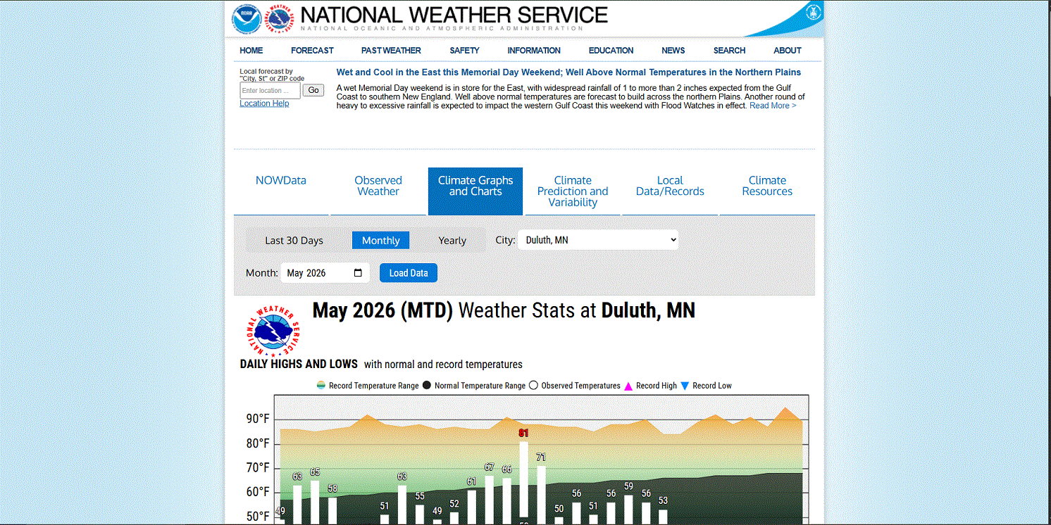
Found a new page under the "Climate and Past Weather" section (link is on the main forecast area page). You have access to data from various stns within the forecast zone. Very cool, and convenient. Worth checking out if you haven't seen it yet.

-
Scattered shwrs/stm moving through the area this morning.
-
May 24 1925: After seeing a high of 99 degrees two days earlier, the Twin Cities picks up a tenth (.10) of an inch of snow. 1908: Tornadoes hit the counties of Martin and Blue Earth. For Sunday, May 24, 2026 1894 - Six inches of snow blanketed Kentucky. Just four days earlier as much as ten inches of snow had fallen across Kentucky, Tennessee and Virginia. Six days earlier a violent storm had wrecked nine ships on Lake Michigan. (David Ludlum) 1930 - A tornado touched down near the town of Pratt, KS, and traveled at the incredibly slow speed of just 5 mph. (The Weather Channel) 1940 - Hail fell near Ada OK to a depth of six to eight inches, and rainfall runoff left drifts of hail up to five feet high. (The Weather Channel) 1987 - Severe thunderstorms in southwest Texas spawned a couple of tornadoes near Silverton, and produced golf ball size hail east of the town of Happy. Thunderstorms also produced large hail and damaging winds in Louisiana and Texas. (Storm Data) (The National Weather Summary) 1988 - Thunderstorms produced severe weather in the southeastern U.S. Thunderstorm winds gusted to 88 mph at Columbia, NC. Baseball size hail was reported near Tifton GA. (The National Weather Summary) (Storm Data) 1989 - Thunderstorms developing ahead of a cold front produced severe weather across the Upper Midwest through the day and night. Thunderstorms spawned 30 tornadoes, and there were 158 reports of large hail and damaging winds. A strong (F-3) tornado caused five million dollars damage at Corning, IA, and a powerful (F-4) tornado caused five million dollars damage at Traer, IA. Thunderstorm winds gusting to 88 mph killed one person and injured five others at Stephensville, WI. (The National Weather Summary) (Storm Data) 1990 - Severe thunderstorms spawned two dozen tornadoes from Montana to Oklahoma. Four tornadoes carved a 109-mile path across central Kansas. The third of the four tornadoes blew 88 cars of an 125-car train off the track, stacking them three to four cars high in some cases, and the fourth tornado caused 3.9 million dollars damage. The third tornado injured six persons who were trying to escape in vehicles. A woman was "sucked out" of a truck and said that at one time she was "airborne, trying to run but my feet wouldn't touch the ground". She also saw a live deer "flying through the air". (The National Weather Summary) (Storm Data)
-
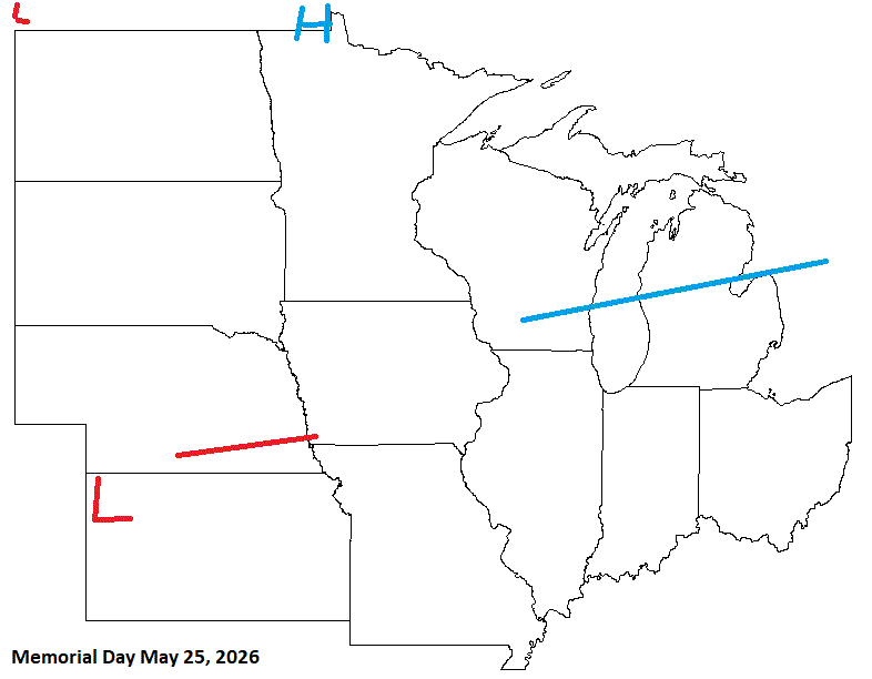
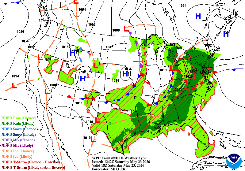
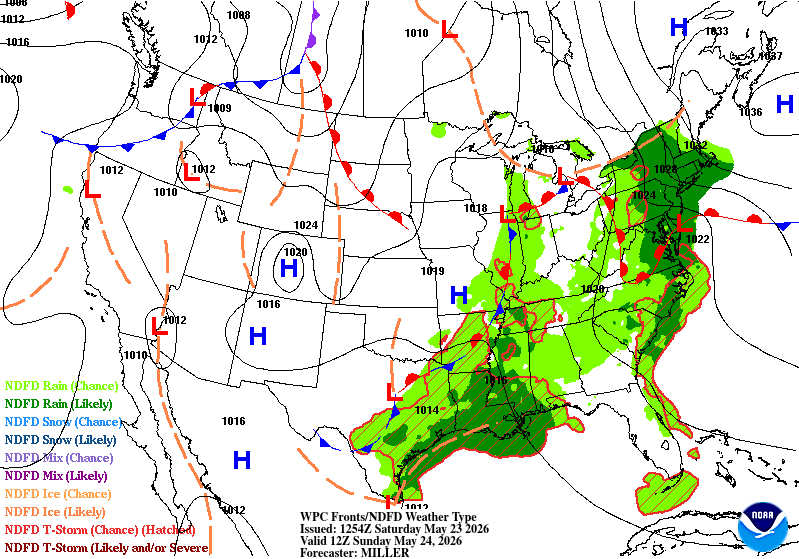
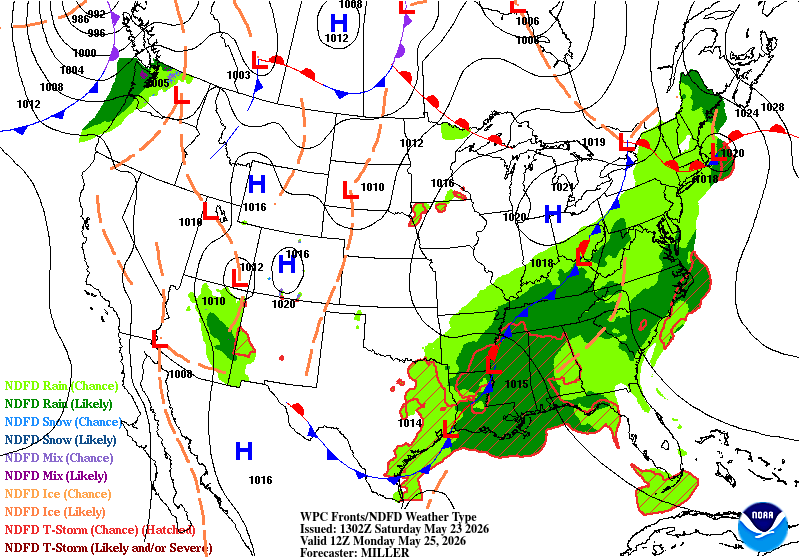
Did ok with this forecast. A little off in the above map for Monday, but thought that might be the case as main front is through the sub by then. Conditions improve from W to E over the weekend. Enjoy your weekend EV1!