
WhirlingWx
-
Posts
404 -
Joined
-
Last visited
Content Type
Profiles
Blogs
Forums
American Weather
Media Demo
Store
Gallery
Everything posted by WhirlingWx
-
Severe T-storm watch for DFW up until midnight. Hodographs look really nice but there's little to no instability here, so overall I think it's a limited threat, but could still see some instances of damaging wind. I have to imagine that the theoretical "boom" scenario of today would play out perhaps in a similar way to the Arlington, TX tornado late last year. Maybe get a spin-up that takes advantage of that helicity/shear, but I still find it unlikely overall, and CAPE might be lower today than it was even on that day. Maybe further southwest of us in central TX has higher tornado potential.
-
I'm pretty sure that Wednesday, probability-wise, did verify a high risk in Alabama, now that more late reports have been added in. Can't really say the same for Mississippi though. Plus, did I agree with the addition of the 45% hatched? Not really, and the event did not verify the aggressive wording of "potentially violent" tornadoes either (again, a good thing). I do agree that we still have a lot to figure out in severe wx forecasting. However, I do want to point out that there was an EF2 tornado in SE Mississippi that crossed into SW Alabama, near or in the southern end of the high risk area, that was on the ground for more than 35 miles and for more than 45 minutes, per a survey by NWS Mobile. There was also an EF1 that tracked over 20 miles in Hale and Tuscaloosa counties in Alabama. IMO, those count as long-tracked. Again, was the outlook perfect? No, but we've seen "busts" that are more egregious than Wednesday ever could be. Like Thursday. (FWIW, pretty sure we did get around 5-10 tornadoes after 12z on Thursday, but they were all weak and outside the highest risk area, which had no severe weather reports). Of course, any time you get hit close to home, it won't feel like a bust for you. All of this discussion is from an objective meteorological perspective, and I think we all agree that people are dealing with losses after this event, which is always tragic. At the same time, it is still pretty miraculous to have had no fatalities.
-
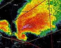
Can't get tweets to show directly on here for some reason, but these images show pretty significant damage in Chilton county, AL. Oakhurst_WX on Twitter: "Very severe tornado damage in Chilton County from the earlier damaging tornado, from Roger Bean on Facebook #alwx (https://t.co/uG9yznDwZP) https://t.co/zwN3SHfB3L" / Twitter
-
TDS in NW Birmingham suburbs again
-
PDS re-issued for that cell
-
Andy Hazelton on Twitter: "@MikeFischerWx Seems like models may have slightly underdone the low-level shear. Not ideal considering how stacked this case already is." / Twitter Birmingham VWP...
-
Okay, okay... it looks like we're all saying pretty much the same thing now, so let's move on to actually discussing what's about to go down today. Thanks y'all As posted above, incoming PDS watch for MS/AL. Also, WF is still currently over far N/NE MS, and cutting through or just NE of the Birmingham metro, based on SPC mesoanalysis as of 16z. Warm air advection is probably going to keep pushing it a bit farther north and northeast, but just how much remains to be seen, as the wedge might be holding on slightly longer than expected. Thoughts? Just saw the post from @yoda as I was typing this. Wow...
-
I think the key is that people say *since* 2011. They don't say that it's "like 2011" or "worse than 2011" so I'm more than willing to accept the statement as something other than pure hype. Once again, it can't be overstated how absurd that day in April really was. But 200-300 m2/s2 of 0-1 km SRH, especially with lots of streamwise vorticity, is more than sufficient for strong tornadoes. While I doubt this will be a case of nearly every cell producing an intense-violent tornado simultaneously, like it seemed to be the case on 4/27, I can imagine that at least a few will be more than capable of producing intense tornadoes, even simultaneously, across the open warm-sector. EDIT: ninja'd and with far less words lol
-
 womp womp With the Day 2 moderate I'm starting to wonder if we end up with back-to-back high risks. Do I expect one? Not really, but with the moderate put up this early, if models continue to trend scarier, there's plenty of opportunities for a high risk to be added for Thursday as well. Yikes. I doubt anybody would have been bold/serious enough to predict back-to-back high risks here
 -
Consider me throwing my hat in the ring for tomorrow as well. I guess it's not a bold prediction based on how strongly worded the D2 outlook was just now. 1250 tornadoes, first high risk tomorrow (March 17), and I'll just throw out another date of April 15 for a second high risk (and last of the year).
-
Severe Weather Threat 3-16-21 through 3-18-21
WhirlingWx replied to cheese007's topic in Central/Western States
That's a really strongly worded outlook. -
With a couple of landspout reports in NW KS/SW NE today, makes for a nice 3-day event. Pretty sure we exceed 15 tornadoes/landspouts for this 3-day period, and yesterday might have exceeded 10 tornadoes.
-
EDIT: NWS Dodge City on Twitter: "We understand there is some concern over a potential brief tornado that occurred earlier near Ensign. We saw the couplet, we saw the drop in CC, but these storms were elevated (not ingesting air from the surface), so it is unlikely a tornado occurred." / Twitter A more appropriate response in this thread, but still...
-
Made a hard left so I thought the entire circulation would be occluding, but then it's just wrapped up a ton south of Howardwick
-
Circulation right over Clarendon, TX
-
Silverton is in danger. Town got leveled back in 1957
-
Wow...
-
New tornado watch has 80/60 probs for tornadoes
-
New MCD out for eastern TX panhandle
-
So if today verifies then does that make the 2021 Plains season already better than 2020?* *verifies away from populated areas
-
Stays enhanced, but keeps the mention of a possible upgrade to MDT later on. Biggest question to them apparently is just how much low-level destabilization occurs.
-
I'm probably beating a dead horse here, but chaser convergence could be pretty brutal tomorrow. Just hoping that everyone keeps their head on a swivel.
-
James Burch got really close to it 3-12-2021 Shallowater, TX Tornado DESTROYS Structure - Close Range DEBRIS!!! - YouTube
-
Chasers confirmed it, warning came out just now. Abernathy, TX is the only real town in the polygon it seems.
-
40/20 TOR probs on the first watch issued today, for parts of NM and TX

