WhirlingWx
-
Posts
404 -
Joined
-
Last visited
Content Type
Profiles
Blogs
Forums
American Weather
Media Demo
Store
Gallery
Everything posted by WhirlingWx
-
Might actually overperform on temps today... Sun is out and limited clouds over my house
-
What does it show?
-
From the FWD AFD .LONG TERM... /NEW/ /Saturday evening onward/ Key Messages: (1) A historic winter storm is poised to impact North and Central Texas, with impacts beginning as early as Saturday morning, continuing through Monday. (2) Extremely cold temperatures, rivaling the December 1989 Arctic Outbreak, are forecast on Sunday and into Monday, with prolonged much below normal temperatures expected to continue through next week. (3) Major impacts resulting in severe stress to the region`s infrastructure (particularly power, water, and highways) are likely. Regional travel will be crippled for days. (4) Additional frozen precipitation will be possible toward the middle of next week, though confidence is low in the details at this time.
-
I don't like the nagging thought in my mind that we could still get missed DESPITE literally being in a warning now. For the record, I would call this a huge disappointment if I don't get at least an inch on the ground. I would still be a little disappointed if it was less than two inches, because technically that wouldn't verify the forecast. Anything >2" I will gladly cash out with. Still a waiting game I guess
-
I've seen a QPF drop off on some models for DFW... not necessarily a complete hole, just a lesser area (as in, say 0.2 or 0.3 rather than 0.4 and higher in the surrounding areas). Makes me pessimistic tbh. We got missed to the west and north, then to the south east, but not at the same time
-
Seeing the latest example of the D.C. snow hole makes me nervous
-
Apparently, there's light lake effect snow falling near Tarrant/Dallas county line?
-
Models that I've seen this morning aren't really discouraging imo. I did notice that FWD changed from stating 3-7" and is pushing 2-6" instead, but I think as things stand right now, we should be able to get to that point. They have some cool graphics, and this link shows some features that I didn't know existed, maybe y'all have seen it but here it is: Winter Weather Probabilities
-
I'm just going to hope that it's more like "trending back to reality" than a "trending north and going to miss us" thing. However, considering the clown kuchera maps still showing 3 feet of snow in parts of Oklahoma, we're probably not back in "reality" territory for the models yet My classes are cancelled, and I wanted to go back to sleep upon realizing? Why can't I? Stupid weather model stress...
-
I might end up having to move down to the Austin area, but I know that as soon as that happens, the pattern will flip. You're welcome. Enjoy beating the February 11-12, 2010 snowstorm while I sit and suffer in 80 degree February temperatures or something.
-
Honestly, we could be seeing those massive weather-related pileups in San Antonio, and maybe even Houston in the coming days. It's crazy to have such a wide scope of freezing temps and ice down here.
-
Also just noticed that the latest long-term AFD mentions "more snow chances" for the middle of next week. Been seeing talks in the MO/KS/AR/OK discussion about that system, but granted it's probably too far away for me to want to discuss, because there is too much that can change between now and then (or between now and the Sun/Mon system, as a matter of fact). Some models do shown us getting a second round in that timeframe though as far as I know.
-
I really hope we do get slammed (by snow). Granted I just woke up to the news of the massive pileup nearby and I'm not happy about that at all. I just hope people can stay safe, regardless of what else happens with the weather here.
-
Segment from FWD's new long-term AFD: The freezer door will then be propped open on Sunday as mid level ridging amplifies over the Northwest U.S. and our polar low over Southern Canada pivots eastward allowing a chunk of arctic air to spread southward through the Plains. A 1050 mb high will surge southward behind a strong cold front but ahead of a compact shortwave ejecting out of the southwest U.S. This will set the stage for some exceptionally cold air to spread into North Texas over the latter half of the weekend into early next week. We`re becoming increasingly concerned for a prolonged cold spell with actual air temperatures falling into the single digits to near 0 across parts of the region by Monday. While the GFS is currently the coldest guidance, other global guidance and ensemble members indicate 850 mb temps falling into the -12 to -17 degree range which would be in the coldest 10% of temperatures in our observed sounding data. In addition, a pool of moisture will reside across much of East Texas and should quickly surge northwestward into the region as strong forcing overspreads North Texas late Sunday into Monday. With column temperatures as cold as currently forecast, widespread moderate to heavy snow would be expected to develop as the shortwave spreads across the Southern Plains. The current forecast will reflect these trends with all snow by late Sunday night and continuing into Monday. While it`s a little early to pin down exact accumulations, as of now, it appears that widespread snowfall amounts of 2 to 4 inches will be possible over a large area of the region. Column temperatures would be cold enough to support higher snowfall ratios than we typically see which could result in significantly heaftier snow totals. North winds 15 to 25 mph could also result in significant reductions to visibility during the snow. This will be a fast moving system, but definitely has the potential for significant impacts to travel and infrastructure across the region. Extremely cold weather will continue into the middle of next week. It should be stressed that this bout of extreme cold may have significant impact to infrastructure over the latter part of the weekend into early next week. Exposed pipes are likely to burst in the prolonged cold. Preparations should be made now to protect exposed pipes or other infrastructure sensitive to the cold. Plans should be made for pets and people. While significant snow is forecast for Monday, the extreme cold and wind will make travel dangerous and snow clearing operations much more difficult. The snowpack is likely to linger and become compacted further complicating the clearing efforts. Dunn
-
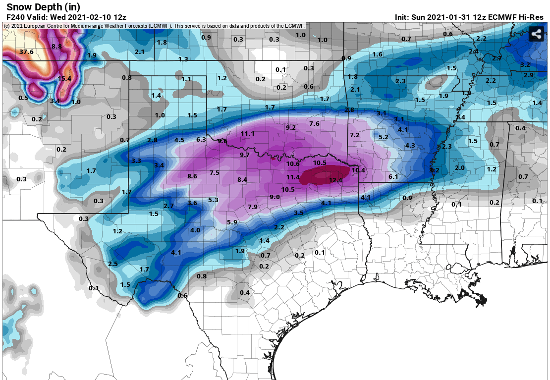
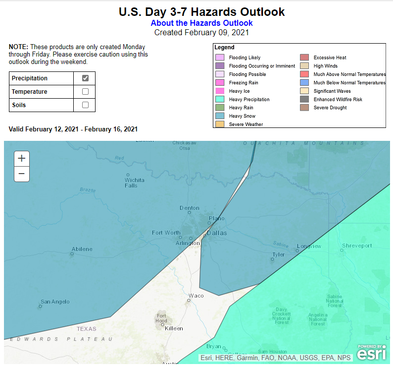
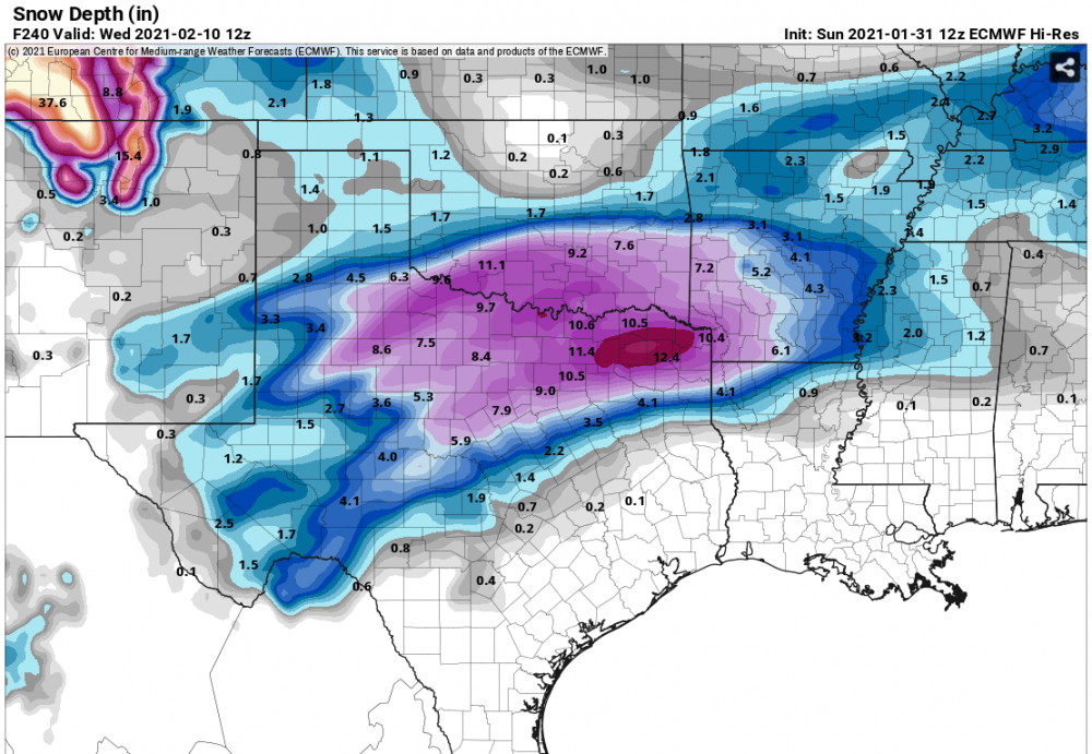
I'm going to assume you can broadly brush these heavy snow areas together on the WPC's new Day 3-7 outlook? I don't see any reason for them to be implying a Dallas county sliver of a snow hole Obviously still several days away so they will likely shift those areas more. 18z GFS still bringing >6" of snow for the metroplex. I'm trying very hard to restrain myself from jumping onto the hype train here.
-
NWS FWD updated and expanded the Winter Weather Advisory to include parts of central Texas, and goes until 3 PM tomorrow. 1230 PM CST Wed Feb 10 2021 ...WINTER WEATHER ADVISORY IN EFFECT UNTIL 3 PM CST THURSDAY... * WHAT...Freezing rain. Additional ice accumulations of up to one quarter of an inch. * WHERE...Portions of North-Central, Central, and Northeast Texas. * WHEN...Until 3 PM CST Thursday. * IMPACTS...Very slippery sidewalks, roads, and bridges are possible. The hazardous conditions could impact Thursday morning's commute, and poor conditions may persist into the afternoon.
-
-
Could definitely get another Winter Weather advisory over the next couple of days for ice/freezing rain here in the Metroplex (Collin county) before the weekend. Good bet that there are gonna be some more problems on the road (I'm not going anywhere though)
-
A guy can dream...
-
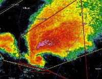
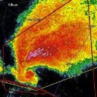
Think there could have been another very brief tornado near Afton, Oklahoma, according to chasers. Still several different tornado-warned storms.
-
I don't know if we're still using this for 2021, but if we are, impressive cold core setup in NE Oklahoma, and parts of SE Kansas. A couple tornadoes have been reported (in mainly rural areas), and a couple of warnings still out for some still-rotating storms in the area.
-
 Quick non-severe storm around 3 PM, and dreary ever since. Gonna have my weather radio at my bedside to wake me up if any severe storms roll through with a squall line overnight.
 -
FWD not going guns blazing on this threat obviously, but they're still pointing out at least the potential for gusty winds/small hail with prefrontal cells, and then an overnight QLCS with a tornado threat depending on interactions with boundaries (i.e. warm front). Still a couple days out, but I guess I'm just getting a little restless with the weather here haha.
-
Yeeeep... I am a little surprised that they dropped the severe risk altogether. Fort Worth's AFD gives me a little hope, but honestly we're just gonna have to wait and see.
-
With our luck, D4 is also gonna be a dreary rainy/misty/cloudy day. In all seriousness, I'm intrigued by the setup. Still some uncertainties, as noted by the SPC in their outlook (cap, degree of surface-based instability, etc.)