WhirlingWx
-
Posts
404 -
Joined
-
Last visited
Content Type
Profiles
Blogs
Forums
American Weather
Media Demo
Store
Gallery
Everything posted by WhirlingWx
-
No longer snowing here. Snowed for like 2 hours but could never properly accumulate on the ground. Edit: transitioned back to very light flurries but nowhere near what it was before.
-
Might actually accumulate on the grass at this rate. Moderate snow still falling but melting on pavement
-
Southern Collin County, and also getting flakes here. It can't accumulate at this rate either but it's better than whatever that weak stuff was (here) last January
-
I'd settle for an inch up here near Murphy, TX. Not sure how feasible it is, still waiting for the atmosphere to moisten up enough over here.
-
It looks like it may already be moving into Tarrant County... so close, yet so far.
-
 Hey guys, I've been trying to follow this closely, but am not very knowledgeable at all in winter weather forecasting/model interpretation (other than staring at snow maps). I appreciate all the insight that y'all are sharing and discussing. I am currently outside any watch/warning/advisory here in Collin County, but I too want in on the action
 -
Storms off the Texas coast have some rotation already, but it also looks like they might be moving almost due north (heading towards or a little east of the Houston metro). Regardless, they have special marine warnings on them for waterspout threats.
-
Watch out until midnight, 40/20 TOR probs
-
How are SSTs and OHC in the W. Caribbean right now? Eta spent a while crawling there.
-
Pretty sure it's got the right front quadrant nailing Puerto Cabezas right now. Unfortunate how it's smashing into the only big population center in the area. Also seen even more videos of flash flooding already.
-
I've seen a few people mention that Gilbert and Wilma were at peak intensity even with an extra outer eyewall(?) By that, do y'all mean like at a similar stage as to where Eta currently is (or earlier, or later in the EWRC)? Not that I anticipate a pressure that low, just relative to the life cycle of this storm.
-
Eta thinking of the wild expectations y'all put out (Not a criticism of y'all who know much more than me, I also thought it'd be sub 910 and still won't throw in the towel on Cat 5)

-
Already some nasty flooding in Nicaragua. Saw a video on twitter of likely dozens of poor cows being washed away
-
https://mobile.twitter.com/WXappraiser/status/1323217109111894017 Destroyed radar dome and obliterated trees in Catanduanes.
-
Easily... Saw Reed say up to 250 mph on Twitter but that's just so difficult to comprehend... Was that him guesstimating or an official figure (again, for gusts)? Edit: Seen a couple other figures of 235 mph gusts, which seems more... realistic, for lack of a better word. Very extreme.
-
Grrr... Me want recon
-
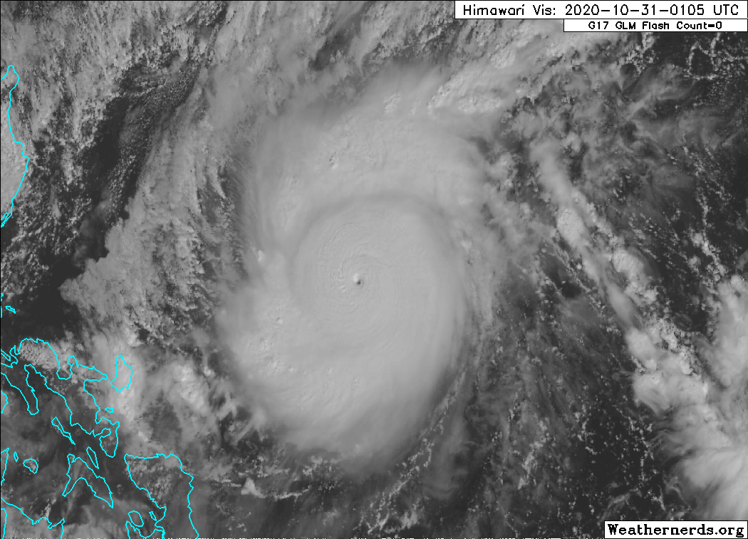
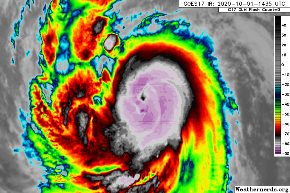
Apparently this thing's gone sub-900? (Not sure if it's official) Looks really neat on satellite.

-
NHC saying it's now reached hurricane strength, 80 mph and 981 mb
-
-
Attention may shift back to the Atlantic soon, but for now, Hurricane Marie has formed in the EPAC. Of note, September went without any hurricanes in this part of the world until now. NHC forecasts it to become a major hurricane w/ a 120 kt peak in around 48-60 hours. Feel free to share any images and discussions below. Hoping for some good satellite images! I'll hand it off to those more knowledgeable now.
-
So when does this one undergo mysterious RI?
-
https://mobile.twitter.com/webberweather/status/1307010641581027328
-
Or we end up with a remnant low tornado outbreak here just because
-
If the Interior NW were to stop our May moderate risk drought the 2nd to last day before the end of the month, it would be fitting for 2020. ...THERE IS AN ENHANCED RISK OF SEVERE THUNDERSTORMS NORTH-CENTRAL OR TO CENTRAL/EASTERN WA... ...SUMMARY... Scattered to numerous severe thunderstorms, offering destructive winds and hail, are most likely between 1 to 10 PM PDT over parts of the interior Pacific Northwest, east of the Cascades. ...Interior Northwest... Primary change is to increase tornado probabilities across parts of central OR. Categorical outlook is largely unchanged. Consideration was given for an upgrade to Moderate Risk in the western portion of the Columbia Basin. Concerns over the spatial extent of the severe wind coverage preclude further upgrading at this time. Thunderstorms will likely intensify after 19Z in a zone of strong deep lift across south-central OR, ahead of an ejecting shortwave trough. Here, robust diabatic heating is underway amid a plume of low to mid 50s surface dew points. This will support a narrow corridor of modest buoyancy with MLCAPE reaching 750-1500 J/kg from central to northeast OR. Greater buoyancy is expected to develop towards 00Z farther downstream in eastern WA to northwest MT where mean-mixing ratios are higher. Surface-based effective-inflow parcels will exist on the west side of the surface front, where low-level winds will be veering with height, hodographs strongly curved, and deep shear relatively maximized. With low-level vorticity also maximized in the frontal zone, multiple supercells are expected. Though the environment generally favors higher-based convection, initial supercells should have the best potential for large hail and a couple tornadoes between about 21-23Z. As the supercells spread rapidly north-northeast, at peak boundary-layer heating over the Columbia Basin, upscale growth into a forward-propagating MCS appears probable. This will increase the potential for severe wind gusts, some of which may be significant, given the favorable combination of steep lapse rates and moderately large buoyancy. Overall setup appears likely to yield a swath of severe wind in the Columbia Basin from north-central OR across parts of central and eastern WA before the MCS moves into British Columbia.
-
https://mobile.twitter.com/pmarshwx/status/1266745452009046019 Appears this may be the only comparable outlook, a very unusual setup nonetheless