
WhirlingWx
-
Posts
404 -
Joined
-
Last visited
Content Type
Profiles
Blogs
Forums
American Weather
Media Demo
Store
Gallery
Everything posted by WhirlingWx
-
Severe Weather for 4/19-4/23
WhirlingWx replied to Tallis Rockwell's topic in Central/Western States
Looks like the watch ended up well south of DFW, so I guess there could be a different one incoming later for here -
Severe Weather for 4/19-4/23
WhirlingWx replied to Tallis Rockwell's topic in Central/Western States
Question: If these storms do form in SE TX, would that limit the moisture/instability that can go up towards DFW and southern OK? -
Severe Weather for 4/19-4/23
WhirlingWx replied to Tallis Rockwell's topic in Central/Western States
Goes right up to the DFW Metro but it's a toss-up if the watch will actually include Dallas county, either way DFW itself would be on the edge of THIS watch -
Severe Weather for 4/19-4/23
WhirlingWx replied to Tallis Rockwell's topic in Central/Western States
I'm observing the models right now and the 14z HRRR shows a cell forming between 1-2 PM and tracking through the northern DFW metro through about 5 PM, within a decent-looking environment. The 12z 3km NAM shows a storm as well through the center of the metro, but more around 4-7 PM. Those two are probably the more ominous of the convection-allowing models, but of course one shouldn't get caught up in the exact placement of the storms. I probably should've looked more at other areas cause on the HRRR at least, storms over SE TX and parts of OK looked interesting as well for a period of time. -
Severe Weather for 4/19-4/23
WhirlingWx replied to Tallis Rockwell's topic in Central/Western States
Yeah with the new outlook that came out, wording sounds like they think storms will form east of us now... Haven't been able to load the graphic nor the outlook text yet though Edit: Just saw the graphics you posted -
Severe Weather for 4/19-4/23
WhirlingWx replied to Tallis Rockwell's topic in Central/Western States
Yeah, if storms initiate right off/near the dryline around the mid-afternoon maybe, we could be in for a wild ride. -
Severe Weather for 4/19-4/23
WhirlingWx replied to Tallis Rockwell's topic in Central/Western States
Tornado warning extended for that same storm. -
Severe Weather for 4/19-4/23
WhirlingWx replied to Tallis Rockwell's topic in Central/Western States
I haven't been looking at models for very long, in fact not at all until recently. A bit of a newbie, haha. If that's part of the thinking here then I see it a lot more clearly. Yup. Seems like there are various scenarios possible as to how it unfolds, with nothing being a given. -
Severe Weather for 4/19-4/23
WhirlingWx replied to Tallis Rockwell's topic in Central/Western States
Definitely, if there are any outflow boundaries, they could set up localized areas of higher risk, but it won't matter if the cap doesn't break. I'm no expert though, and I really don't know what to think about the setup overall. The Weather Channel app is telling me there's about a 90% chance of storms tomorrow, as is also suggested by one future radar website I pulled up. However, the convection-allowing models I looked at on pivotal weather for the most part show little convective activity over here, with a couple exceptions, but nothing particularly concerning (in the DFW area). The ingredients do look to be in place though, so I am just not sure. -
Severe Weather for 4/19-4/23
WhirlingWx replied to Tallis Rockwell's topic in Central/Western States
It caught my attention too, because I do remember the outlooks on April 3, 2012 + Dec. 26, 2015 + Oct. 20, 2019. Stuff like that also came to mind, stuff like May 18, 2019 + some other day in June last year that I can't remember + Jan. 10, 2020 (another time in late-April of 2016, where I believe we even had a PDS Watch in the area). In those cases, the events either busted (in our area) or were just not as severe as forecasted (again, in our area). Of course, mesoscale details on the days of these events had a lot to do with either increasing or decreasing the threat. April 29, 2017 also came to mind where the cap broke over to our east and things went nuts in Van Zandt county especially. -
Either early today in the morning or yesterday I remember seeing that the timing of this system was going to temper the severe threat (moving through overnight without a very destabilized atmosphere). Those runs definitely show the system slowing down and I think in ABC 33/40's most recent Xtreme Weather video James Spann noticed a slower trend as well which meant a higher severe threat. Yikes.
-
Yeah that's what I was wondering, cause that's where I would see it making the most sense. Indeed, so many things to consider and track at the same time.
-
Does it feel like there are discrepancies between the watch outline and the summary? This new watch outline mentions several tornadoes and a couple intense tornadoes likely yet the summary only states "a few tornadoes" (albeit with the risk of stronger tornadoes).
-
For what general area are you looking at those VWP's?
-
Looks like new SPC meso says trends towards supercellular mode are apparent over SE TX and far SW LA Edit: The page didn't refresh for me so I thought nobody had commented on the environment in SE TX. My bad
-
Oh shoot a moderate, SPC isn't loading properly for me yet though so I can't see the graphic and outlook text myself
-
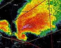
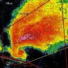
The semi-discrete cells in Southern Mississippi showed us what more this outbreak was capable of. If there had been more of them, this likely would be considered a 'Super Outbreak' with more violent tornadoes, as you said. Fortunately for the people affected, this wasn't the case.
-
Were the two supercells that produced the southern Mississippi tornadoes the only sustained semi-discrete supercells of the entire outbreak? From radar I can't remember seeing any others that produced (maybe I'm missing some), as many of the tornadoes came from the QLCS (and embedded supercells within it). Edit: Actually looking again I guess overnight Saturday into Sunday there were some in Texas, but other than that I can't see any other noticeable ones apart from over southern MS
-
So based off of what we know so far: this event has had the most tornadoes in one continuous tornado outbreak since the 2011 Super Outbreak (>115), has had the most violent tornadoes since Pilger, NE in 2014 (2 EF4's), the most EF3+ tornadoes since the 2011 Super Outbreak as stated above (12), and the most tornadic fatalities since April 27-30, 2014 or March 2-3, 2012 (with between 30 and 37, I'm struggling to get a handle on the exact number). Then again, I used Wikipedia to get exact numbers on tornadoes in outbreaks since 2011. Someone may correct me if I'm mistaken in this.
-
That is quite the company
-
Hi all! I've been following this forum for some time and this thread in particular from the start of it. Just decided to sign up. What I can say is this is likely one of the most severe tornado outbreaks I've followed since I got interested in severe weather. It's really sobering to see the devastation and loss of life that's occurred as a result. Thank you all for posting your thoughts and updates before/during/after this event. Regarding the tornadoes themselves, I don't know if I've seen a more prolific nighttime QLCS in the past several years, and those monster tornadoes in Mississippi were a sight to behold on radar and on the ground.
