
WhirlingWx
-
Posts
404 -
Joined
-
Last visited
Content Type
Profiles
Blogs
Forums
American Weather
Media Demo
Store
Gallery
Everything posted by WhirlingWx
-
A bit outside this subforum I think, but the storm north of Peoria, IL has a look to it, can't see much else at the moment other than large hail showing up. Edit: Ehh I don't know I can't see the velocity and after the next scan makes it look a little less organized on reflectivity? Honestly don't know. Hail core still there for sure. I don't know much about the environment around it either.
-
Yup, same area
-
TOR warning in SE TX, south/southwest of Houston, separate from the main system TORNADO WARNING NATIONAL WEATHER SERVICE HOUSTON/GALVESTON TX 222 PM CDT TUE APR 28 2020 THE NATIONAL WEATHER SERVICE IN LEAGUE CITY HAS ISSUED A * TORNADO WARNING FOR... SOUTHEASTERN FORT BEND COUNTY IN SOUTHEASTERN TEXAS... SOUTHWESTERN BRAZORIA COUNTY IN SOUTHEASTERN TEXAS... * UNTIL 245 PM CDT. * AT 222 PM CDT, A SEVERE THUNDERSTORM CAPABLE OF PRODUCING A TORNADO WAS LOCATED NEAR WEST COLUMBIA, MOVING SOUTHEAST AT 20 MPH. HAZARD...TORNADO AND QUARTER SIZE HAIL. SOURCE...RADAR INDICATED ROTATION.
-
First noteworthy MD of the event Mesoscale Discussion 0484 NWS Storm Prediction Center Norman OK 0155 PM CDT Tue Apr 28 2020 Areas affected...southeast Kansas...eastern Oklahoma...southwest Missouri...northwest Arkansas Concerning...Severe potential...Watch likely Valid 281855Z - 282130Z Probability of Watch Issuance...95 percent SUMMARY...Storms will develop by 21Z along and ahead of a cold front, and quickly become severe. Damaging hail, wind, and a few tornadoes are all possible. DISCUSSION...A surface trough extends from western OK northeastward across IA, with a low over northwest OK at 19Z. Meanwhile, a stronger cold front was surging across central KS, and across the Panhandles. Strong instability has developed near the surface trough, beneath very steep lapse rates aloft. Early and midday soundings show 700-500 mb lapse rates to around 9 C/km, beneath modest northwest flow aloft. Meanwhile, southery surface winds are maintaining mid 60s F dewpoints south of the cold front, resulting in strong instability. Storms are likely to develop along and ahead of the surging front over KS, and become severe as they encounter the stronger instability. Large hail is likely initially, transitioning to damaging winds. Initial cellular activity may produce a brief tornado. As the storms move southward across eastern OK, access to greater low-level SRH may yield a few tornadoes, perhaps with cells in the line or brief QLCS. Farther west, steep low-level lapse rates exist over western OK and northwest TX, and this may help to eventually break the cap as the wind shift moves south toward I-40 later today. While a capping inversion does exist, the western fringe of the frontal storms will likely be severe, producing damaging hail and wind. ..Jewell/Thompson.. 04/28/2020
-
Was so disoriented when my weather radio woke me up that I thought it was Tuesday night/Wednesday morning already
-
The current models show wind shear looking like it will be displaced away from most(?) of that threat area until late in the night, so for now that looks like it'll keep the tornado threat from reaching the levels that we've seen in the past couple of weeks.
-
Severe Weather for 4/19-4/23
WhirlingWx replied to Tallis Rockwell's topic in Central/Western States
Yep, Paris has a little under 25 minutes at this current rate, hopefully the storm weakens by then. -
Severe Weather for 4/19-4/23
WhirlingWx replied to Tallis Rockwell's topic in Central/Western States
New confirmed TOG in Bryan County, OK -
Since the heart of Darien is north of the name on the map, hopefully the most populated areas are spared Edit: Looks like it's turning a tad north now...? I'm not sure anymore
-
Severe Weather for 4/19-4/23
WhirlingWx replied to Tallis Rockwell's topic in Central/Western States
There are new cells developing in SW LA, are those a concern wrt a continued tornado threat? -
Severe Weather for 4/19-4/23
WhirlingWx replied to Tallis Rockwell's topic in Central/Western States
Aaaaand the new TOR watch goes into those same southern MS counties... The NWS Storm Prediction Center has issued a * Tornado Watch for portions of Eastern Louisiana Southern Mississippi * Effective this Wednesday night and Thursday morning from 945 PM until 500 AM CDT. * Primary threats include... A few tornadoes likely with a couple intense tornadoes possible Scattered damaging winds likely with isolated significant gusts to 75 mph possible Scattered large hail and isolated very large hail events to 2 inches in diameter possible SUMMARY...A long-tracked supercell with a history of tornadoes will continue east from central Louisiana, while additional supercells upstream will likely grow upscale into a broadening cluster overnight. -
Severe Weather for 4/19-4/23
WhirlingWx replied to Tallis Rockwell's topic in Central/Western States
NWS Lake Charles is live streaming apparently... https://www.pscp.tv/w/1gqxvEVYEreJB Still no idea what they were doing 10-15 minutes ago though... -
Severe Weather for 4/19-4/23
WhirlingWx replied to Tallis Rockwell's topic in Central/Western States
PDS Warning now per SVS -
Severe Weather for 4/19-4/23
WhirlingWx replied to Tallis Rockwell's topic in Central/Western States
-
Severe Weather for 4/19-4/23
WhirlingWx replied to Tallis Rockwell's topic in Central/Western States
Short video but wow, this person is really close, no real condensation funnel but the damage is there occurring just down the street. -
Severe Weather for 4/19-4/23
WhirlingWx replied to Tallis Rockwell's topic in Central/Western States
Including an RV park... -
Severe Weather for 4/19-4/23
WhirlingWx replied to Tallis Rockwell's topic in Central/Western States
Really hoping this did indeed cycle over Jasper. Looks like more deaths in Oklahoma too -
Severe Weather for 4/19-4/23
WhirlingWx replied to Tallis Rockwell's topic in Central/Western States
Forgot about the MD oops, yeah I remember it now. -
Severe Weather for 4/19-4/23
WhirlingWx replied to Tallis Rockwell's topic in Central/Western States
Someone stated in the thread for 4/23 that the monster cell in SE TX and the one near the Red River could be/are already long-tracking cells, seems about right. -
Severe Weather for 4/19-4/23
WhirlingWx replied to Tallis Rockwell's topic in Central/Western States
The motion shown in the videos was certainly indicative of a powerful tornado; do you have specific examples of damage photos/videos that are evident of that sort of rating? I haven't found too much on that yet -
Severe Weather for 4/19-4/23
WhirlingWx replied to Tallis Rockwell's topic in Central/Western States
Sidenote: I noticed this as well, MD out for the area as well -
Severe Weather for 4/19-4/23
WhirlingWx replied to Tallis Rockwell's topic in Central/Western States
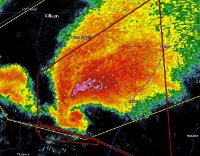
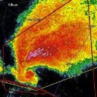
Not good... The SE TX storm looks textbook btw, sorry I know that it's not the focus though -
Severe Weather for 4/19-4/23
WhirlingWx replied to Tallis Rockwell's topic in Central/Western States
Multi-vortex TOG according to KOCO livestream. Near Bromide Northern two supercells in OK seem to be running into each other. -
Severe Weather for 4/19-4/23
WhirlingWx replied to Tallis Rockwell's topic in Central/Western States
Really? Oh no- -
Severe Weather for 4/19-4/23
WhirlingWx replied to Tallis Rockwell's topic in Central/Western States
I don't think anyone has mentioned the TOR Watch for SE TX and Louisiana, it has 70/50 TOR probs, and there is one cell there looking pretty intense with continued TOR warnings
