
WhirlingWx
-
Posts
404 -
Joined
-
Last visited
Content Type
Profiles
Blogs
Forums
American Weather
Media Demo
Store
Gallery
Everything posted by WhirlingWx
-
Over 470k people in the extended warning now...
-
Could be recycling at a bad time because by the time it ingests all that other convection it'll be far closer to the B'ham metro
-
Yup, first of the day now... wonder how long it'll go...
-
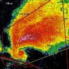
went full BWER EDIT: ninja'd and by radar image ^
-
Could be why the TOR risk was kept at 30%, just from a confidence standpoint. Again, *the SPC risk has no impact on the event itself*
-
okay welp I imagine we're going 45% in a couple minutes EDIT: or not
-
Gensini is just going ALL in, and I mean ALL in... I don't really know but he's definitely respected so I think it's pretty noteworthy. Though I don't seriously think SPC issues a 60% sig unless we're in the midst of Super Outbreak v3 in about 3 hours (which again, is unlikely *to be clear*). I would probably just shift the high risk a little S/SE honestly and keep the TOR risk at 30%... but I'm an amateur at best, so again, I really don't know. Anyone else can chime in on their thoughts on it (some have already).
-
I think something to keep in mind, is that the volatile environment that's expected to occur was forecasted to materialize with *full* cloud cover from pretty much every model I saw. The fact that there are still clouds at this time doesn't mean the threat is any lower than it was before. Of course, maybe at this time tomorrow we'll be talking about something that ended up limiting the threat (which I honestly hope happens). Also, as pointed out just above, the highest threat appears to be slightly north/west of Central Alabama anyways (which, again, doesn't mean the area is out of the woods right now). Even while mentioning that, there is always the possibility that the threat gets shifted a little south than what's currently forecasted.
-
what's it doing?
-
inb4 60% sig /s
-
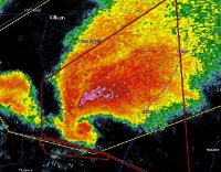
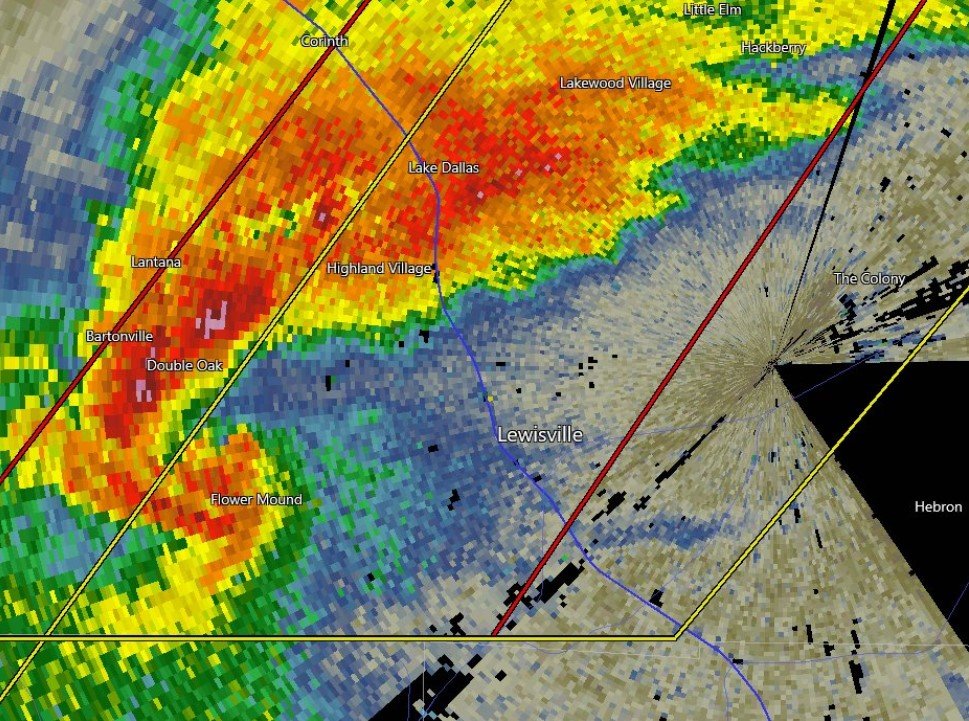
Yep, you called it. Surprised it doesn't include Denton county, where there is literally a tornadic supercell-? Goes until 4 AM... not a fan.
-
just gonna drop in this cropped radar images I got off of twitter cause they're better quality than anything I could have
-
Yeah lol. I just checked back in to twitter and immediately was greeted by radar images of the TOR-warned supercell in Denton county, holy moly at that structure though.
-
Yeah, I figured cause nothing here seemed right. Will delete that post because that sounding is absolutely useless lol
-
Hopefully should pass to the southeast, but Kaufman county might need to watch it closely down the line4 EDIT: Hmmmm.. not fully sure that it misses Dallas county entirely now... but we'll see.
-
Max Olson got the tornado earlier (my links are embedding and I don't know how to fix this setting if someone could pls help lmk lol) Max Olson on Twitter: "#Tornado east of Hamilton, TX about 5 minutes ago, has since lifted. @NWSFortWorth https://t.co/EQnTEvqhXV" / Twitter
-
Tornado warning for Van Zandt county... north of Canton
-
I doubt it would get extended unless we have some ongoing tornadic storms that actually look like they'll travel north of the outlined area.
-
Haven't been able to pull up the watch info but probably has relatively low TOR probs given that the wording was "a couple tornadoes possible"
-
Tornado watch just issued up to the line of counties south of Dallas/Tarrant, but the watch does include Kaufman county as well
-
18z HRRR is a bloodbath EDIT: this is not to say that I expect it to verify. The failure mode of crowded warm sector has been greatly discussed, and is still a very valid concern, and something that we won't know for sure until tomorrow. That isn't to say that the HRRR should totally be tossed.. but yeah
-
Well, just looking at those 4 dates mentioned, all of them DID have an EF3 or higher. 4/14/12 had 5 EF3s and 1 EF4 (yes, I know "violent" was being used in a different context for that D2 outlook, but I'm including it anyways). 4/24/10 had 3 EF3s and 2 EF4s, as did 3/01/07. 4/07/06 had 2 EF3s. My source is Wikipedia lol but it's not bad for information on tornado outbreaks. Also, about this, I believe you are correct about "intense" referring to EF3+ tornadoes. As for the hatched area thing, you are also correct, in that the hatched area represents a 10% or greater chance of an EF2-EF5 tornado. Anything EF2+ would verify their outlook from a probability standpoint. Usually, what differentiates their use of "strong" vs. "intense" vs. "violent" when it comes to their actual technical discussion is based on what the forecaster views the potential severity/ceiling of the event as. A setup that could conditionally produce sigtors will look different from a setup that screams more specifically higher-end tornado potential, but the probabilistic graphics don't communicate that, so you might see a different choice of words in the discussion to indicate that thinking from a human forecaster's perspective. Mesoscale accidents can happen that could produce an EF4+ on a "lower-end" (kind of an oxymoron) significant tornado day, but in general, you could probably tell a setup that could produce a couple EF2s from one that could produce several EF3-EF4+ tornadoes. All of this has little to do with tomorrow from an actual meteorological analysis, but I hope this answers your questions
-
I just realized I haven't looked outside all day so I didn't realize it was actually clear out kind of thought it was another wimpy WAA source of instability lol Looking at models, I feel like the highest threat could be *just* south/southeast of you and I, but with where the warm front sets up I will also be watching regardless. Also seems like DFW's largest recent hailstorms have been in March, so... there's that.
-
So, about the 3km NAM...
-
 Do you wanna change this to the 25th? I'm assuming that when you made that prediction, you were looking at the event from the (then) long-range models at that time...


