

Modfan2
-
Posts
3,465 -
Joined
-
Last visited
Content Type
Profiles
Blogs
Forums
American Weather
Media Demo
Store
Gallery
Everything posted by Modfan2
-
I am in town the 12th-20th, so might be able to make something
-
I was going to say, radar was more impressive earlier this am than now.
-
Another good place for a Summer GTG
-
Near record lows here are in S FL this am which is laughable. Last 3 days have been fantastic in the 85-88 range with a nice east wind…..Not so much Orlando and points north.
-
Not even night time lows down here; enjoy that!
-
Speak for yourself, I’m at Universal Studios and it’s like 95 with a DP of 77.
-
Glad we don’t live there Lol!
-
Got plenty down here in S FL if you want some!
-
My Buddy out golfing at Heritage CC in Charlton had to taunt me sending this; to golf down here in the summer you have to get out early.

-
I remember a derecho that hit the Maryland area (maybe 2011/12 ish?) that did a ton of damage; had to drive portable generators down to aid recovery.
-
Looks like a nice drink for many!
-
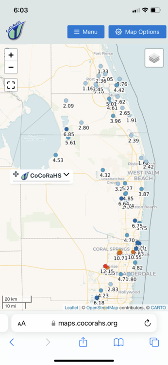
 Not nearly as much up here in Martin County; you guys have had a wet last 30 days or so, not so much up here.
 -
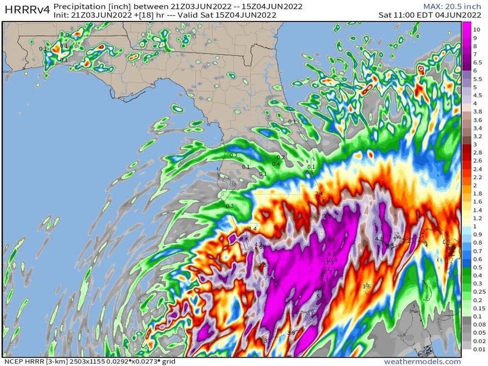
Stein breaker down here; hopefully heaviest should be south of me but HRRR saying another 7” to go!
-
Looking at the radar it appears precip appears to fall apart Lake Okeechobee north?
-
That’s why I asked earlier if maybe this forming/Tracking a little further south
-
Is it possible that the shear is stronger pushing it a little further south?
-
The precip north of West Palm has lightened as it comes north
-
I’m a Masshole too lol! Rain will be the biggest problem down here; although it has been fairly dry over the last month where I am areas south of Palm Beach of had 6-12”.
-
Areas east of 84 under 2” or the last month
-
Areas of S FL, south of West Palm have been pretty wet over the last 30 days so this additional rain will not help. The are some small pockets further north.
-
Sure that’s not just the sea breeze?
-
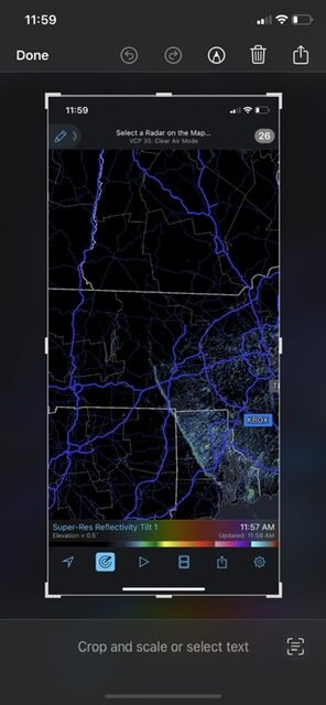
I mean you could see the front pushing into Windham County and then it’s like it fell apart. I tried the OKX radar and it doesn’t see it at all??
-
Is the front washing out in Eastern CT?
-
Can see the outflow from the BD front on radar
-
Where?


