

NorthHillsWx
-
Posts
7,369 -
Joined
-
Last visited
Content Type
Profiles
Blogs
Forums
American Weather
Media Demo
Store
Gallery
Everything posted by NorthHillsWx
-
Storm gusted out before it got here but we’re getting the goods in the rainfall department finally
-
I have to correct my total from Chantal. That was my weekly total including last weeks rain. We received just 0.52” from Chantal here. I was at the beach during the storm and didn’t know I was looking at weekly. Our monthly total is 1.11”
-
To my post above, one thing I believe may have happened here was the circulation was much more mature and deeper than forecasters had expected. A storm that had been forecast to degenerate into a trough in the Carolina’s largely kept its surface circulation intact into the mid Atlantic. This led to a much stronger southerly and easterly flow which enhanced moisture transport and efficiency longer than expected so the “core” was able to sustain itself longer than expected. I think when you see weak storms hit land a lot of times they kind of vanish inland and just their moisture is left but when they become more vertically stacked and mature it takes them longer to wind down and you can see a core of heavy rain sustain itself longer. That’s my 0.02 as to why Chantal was so much worse than forecast this weekend
-
This was a huge forecasting miss in the rainfall department. The watches hoisted explicitly stated 1-3” with isolated totals to 5”. We ended up seeing widespread 4-7” totals with isolated amounts to nearly 1 foot! At least the areas were correctly identified from a watch standpoint but there is a huge difference between a watch for 1-3” of rain and isolated flash flooding and what happened including historic river flooding. This needs to be reexamined as to why forecasts were so grossly off for rainfall totals. Tropical systems are generally “easy” to forecast in this department as the are organized and have many runs of computer models analyzing ongoing convection so you don’t usually misses of this caliber with an organized tropical system
-
We finished with 1.11” from Chantal
-
Obviously hurricanes Florence and Michael had catastrophic flood events for parts of central NC but that was mostly east of the areas impacted by Chantal. I think these areas you’d have to go back to 1996 Hurricane Fran to find anything close to this. You keep seeing the record crests from that storm mentioned in NWS flood forecasts as it was the benchmark for these areas in terms of river flooding which makes this all the more impressive
-
With the events in Texas this flood event is definitely being overshadowed but this is a devastating flood for parts of NC with several rivers nearing and even exceeding all time record crests
-
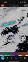
Some places west of Raleigh have seen nearly 1 foot of rain! Forecast was for amounts of 1-4” with isolated totals of 6”. Per RadarScope I’m seeing widespread 5+” totals with several areas more than double that.
-
About the same here in Raleigh but I’ll take it over the nearly 1 foot near chapel hill. Also the biggest rainfall event here in more than 3 weeks so we’ll definitely take it
-
In Morehead city we just had a nasty squall move through with likely some 40 mph gusts. Wind is generally 20-25. Looks like ocean isle to Myrtle beach got a decent little blow from this storm overnight
-
Several buoys just east of Charleston are now measuring gusts around 40 kts on the west side of the circulation. With strongest winds on east side it may be a little stronger than 35 kts already
-
The system looks much more organized this morning with the COC more easily found on first visible images this morning. Overnight convection mainly east of the center has continued and there are some new bursts just east of it as I speak. With shear decreasing and an improved look this morning I would expect steady strengthening until landfall. Probably a 50-55kt ceiling. NHC notes the possibility of center reformation under the bursting convection and the storm has consistently been moving east of track so I wouldn’t be surprised if areas further north than current watch area, maybe up to cape lookout, end up seeing some of the worst weather from this lopsided storm
-
Satellite imagery is a bit deceiving as the MLC is well east of surface circulation and surface center is diffuse. Will be interesting what NHC goes with at 5, but it’s not far off from a name. IMO this very likely gets named and areas east of landfall have a nasty weekend
-
It’s a bit of a radar hole but we nickel and dimed our way to 0.32” which is enough to water the yard for the first time in almost 2 weeks Picked up 0.27” more from a couple evening storms. 0.59” on the day
-
-
Despite 80-90% rain chances last night we’re sitting at 0.00” storm total here for the front
-
Monthly stats: Highest temp: 100.8 Days above 100: 3 Rainfall: 1.83” Finished last 10 days of month without rain (except 0.02 over 2 days)
-
10 days since our last rain and still just 1.83” for the month looks likely to be our total
-
Missed thunderstorm roulette again but what a beautiful outflow-cooled evening
-
Awesome afternoon. Played putt putt with the kids and didn’t die like expected
-
It’s been a wet month for the state my house has been about the only rain hole there has been. Honestly we haven’t had a heavy rain this month. Thankfully first couple weeks provided consistent rains
-
Hit 100 for 3rd time in 5 days… 100.2 today and managed to miss thunderstorm roulette again. Our 1.83” monthly total looking extremely weak compared to everyone else
-
98.4, HI 105. Considerably hotter than yesterday here
-
Topped out at 95 but good news was HI was mostly 100 or less as humidity was way down from last few days
-
It’s really not that bad out here today. Currently 91 with a HI of 99. Sadly, that feels fine after the last few days


