pen_artist
-
Posts
80 -
Joined
-
Last visited
Content Type
Profiles
Blogs
Forums
American Weather
Media Demo
Store
Gallery
Everything posted by pen_artist
-
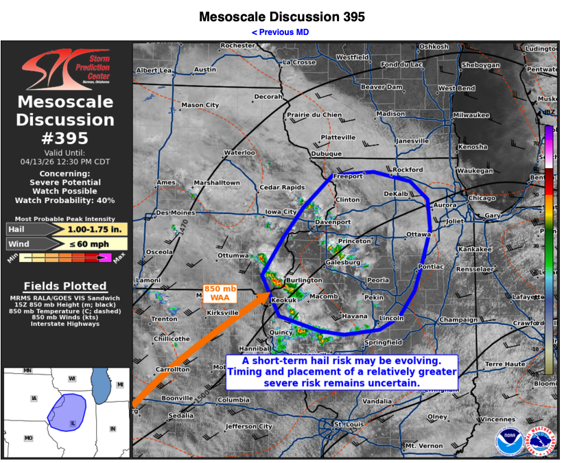
Bit of an appetizer ahead of likely busy next few days Mesoscale Discussion 0395 NWS Storm Prediction Center Norman OK 1103 AM CDT Mon Apr 13 2026 Areas affected...portions of extreme eastern Iowa into western...central...and northern Illinois Concerning...Severe potential...Watch possible Valid 131603Z - 131730Z Probability of Watch Issuance...40 percent SUMMARY...Some hail (possibly over 1 inch in diameter) may occur with gradually intensifying storms over the next few hours. It is unclear if these storms will pose the greatest severe risk this afternoon, or if the greater risk will occur with later storms. DISCUSSION...850 mb troughing is underway across the Plains states into the Midwest, with 15Z mesoanalysis showing the northeasterly terminus of a LLJ currently positioned along the IA/IL/MO border. Here, an 850 mb Td gradient exists, with modest WAA likely supporting the gradual intensification of elevated convection within this regime. The 12Z ILX observed sounding and 15Z mesoanalysis depicts 700-500 mb lapse rates in the 8-8.5 C/km range, contributing to MUCAPE approaching 2000 J/kg. These storms are encroaching on a region of stronger 500 mb southwesterly flow, driven by a departing upper trough over the eastern U.S., which is resulting in 30-40 kt of effective bulk shear ahead of the storms. If storms continue to intensify, it is plausible that at a hail threat may materialize over the next few hours, with some stones potentially exceeding 1 inch in diameter. Short-range high resolution ensemble guidance is providing mixed signals regarding the evolution of this convection. Some deterministic CAMS show that the ongoing storms eventually consolidate and develop into stronger supercell structures in northern IL by afternoon. Other guidance members depict the ongoing storms oscillating in intensity, while stronger storms develop later. As such, there is an appreciable degree of uncertainty as to the evolution of the longer term severe threat with these WAA storms. All this being said, convective trends will continue to be monitored for the need of a WW issuance. ..Squitieri/Guyer.. 04/13/2026 ...Please see www.spc.noaa.gov for graphic product... ATTN...WFO...LOT...ILX...LSX...DVN... LAT...LON 40829153 41349115 41809076 42269021 42318942 42178872 41918839 41478835 41028850 40608866 40238895 40058932 39988999 40039043 40249121 40829153 MOST PROBABLE PEAK WIND GUST...UP TO 60 MPH MOST PROBABLE PEAK HAIL SIZE...1.00-1.75 IN
-
Illinois and warm fronts this year
-
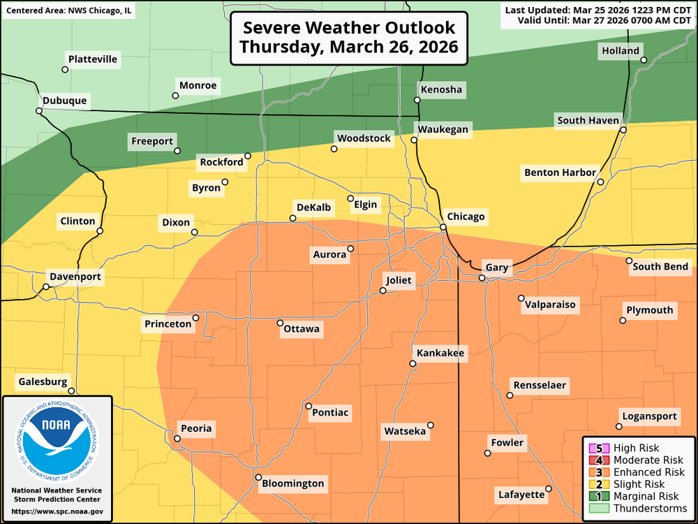
And obviously still conditional but SPC covering the possibility of more robust severe tomorrow. Definitely all dependent on morning convection
-
White Sox have cancelled their home opener in anticipation of tomorrows svr threat and rain
-
Definitely can't complain about the weekly opportunities we have had for severe the last few weeks. To me, it is feeling more active than last year around this time. But I will admit I haven't actually gone back and verified. Speaking specifically for NIL.
-
Stoked for you!
-
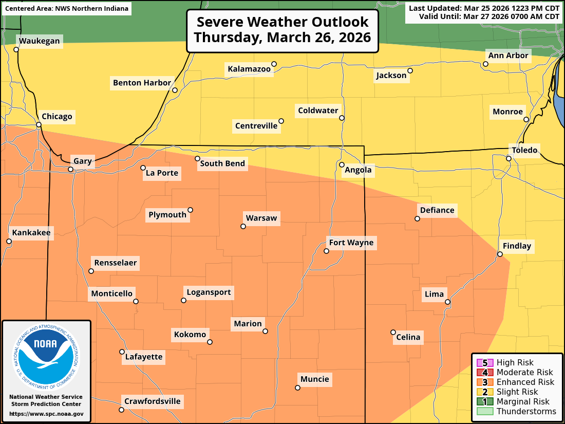
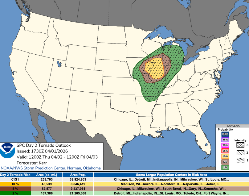
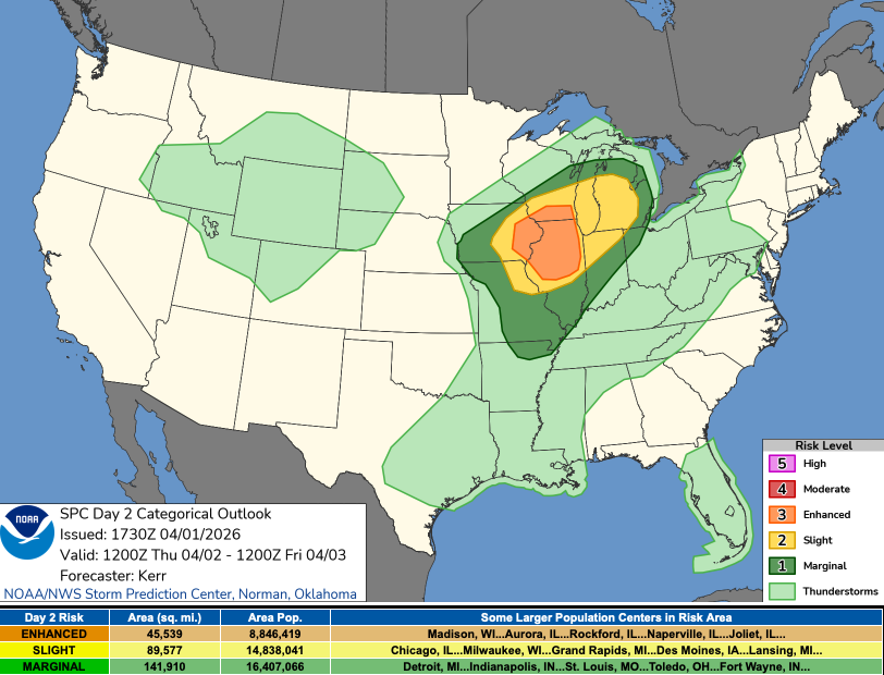
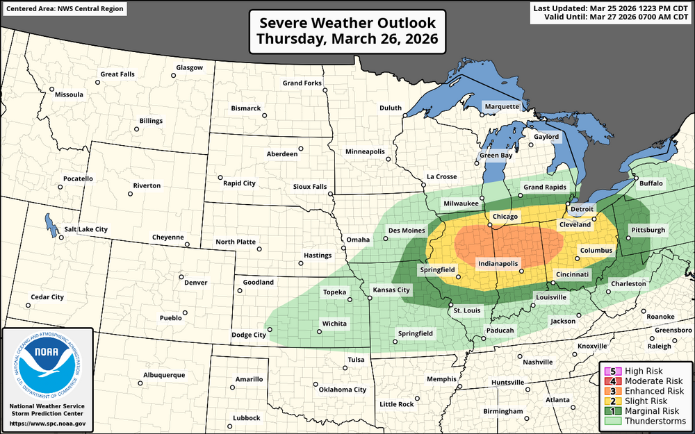
Enhanced risk introduced. For LOT CWA essentially the Eisenhower and south. Figured it might be worth a thread.

-
Good breakdown by Trey on the Kankakee supercell
-
Man, would've been a lot of damage reports if things were leafed out. Glad that isn't the case
-
Thread here:
-
How much further north will the warm front nudge? Still about 36-48 hours to see but looking like our first crack at some true severe for Central and N IL. Also storm initiation a slight question with the latest 00z models, specifically NAM3km.
-
Insane radar presentation with that MI cell. Definitely something on the ground. Getting shades of the tornado supercells in Portage back in May '24. Edit: Confirmed, pretty large cc drop.
-
Manifesting warmth and active weather for all this month ahead
-

1/24-1/25 Major Winter Storm - S. IL, IN, and OH
pen_artist replied to A-L-E-K's topic in Lakes/Ohio Valley
Bringing this back to the front of the thread. Clutch local event for some who originally didn't look like they'd get more than a dusting! -
1/24-1/25 Major Winter Storm - S. IL, IN, and OH
pen_artist replied to A-L-E-K's topic in Lakes/Ohio Valley
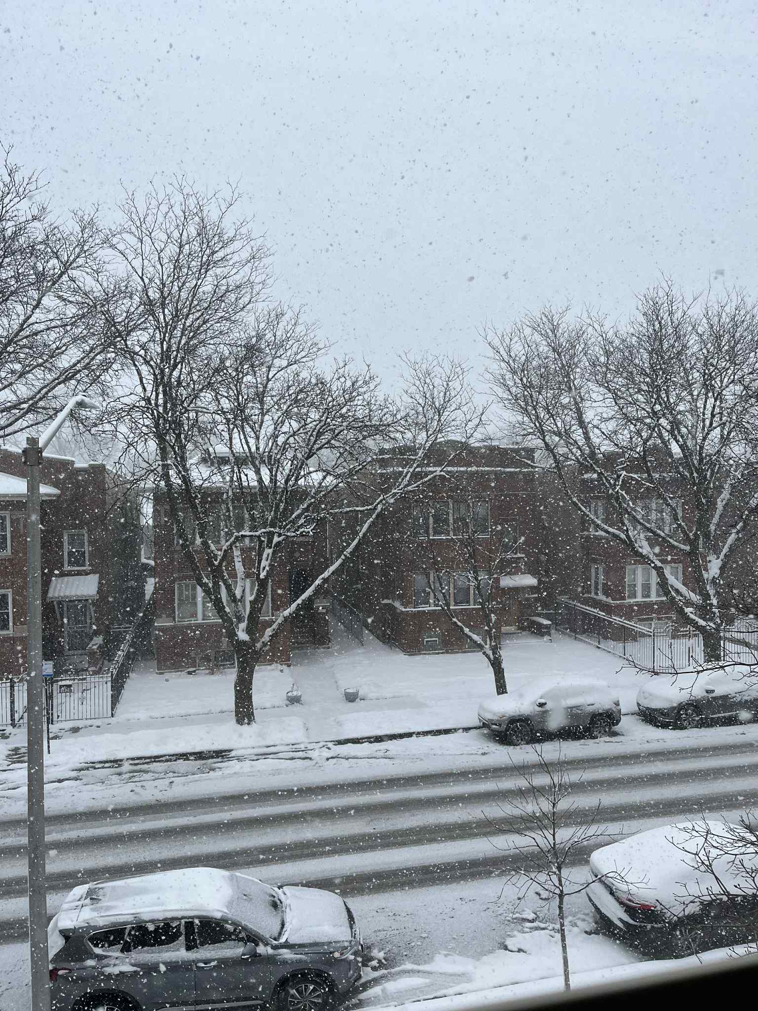
Dumping out here on Austin blvd in Oak Park. Currently sitting close to 5" if not a little more.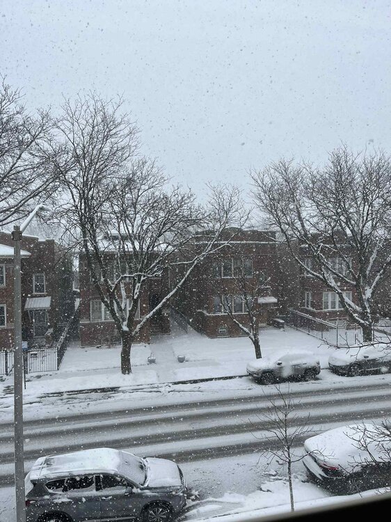
-
1/24-1/25 Major Winter Storm - S. IL, IN, and OH
pen_artist replied to A-L-E-K's topic in Lakes/Ohio Valley
About 7.5 miles away directly west of the lake in northern Oak Park. Like where I sit to hopefully get a couple inches out of this. -
11/8-11/10 First Snow and Lake Effect Event
pen_artist replied to Geoboy645's topic in Lakes/Ohio Valley
Same as a few other posters, moved further east to border of Oak Park and Austin this weekend. Liking my odds of getting in on some 6+ snowfall to welcome me into the new space :) -
2025 Short Range Severe Weather Discussion
pen_artist replied to Chicago Storm's topic in Lakes/Ohio Valley
Got a TOR warning now just west of Elgin -
2025 Short Range Severe Weather Discussion
pen_artist replied to Chicago Storm's topic in Lakes/Ohio Valley
Will see what happens, got activity blowing up west now near I-39 -
2025 Short Range Severe Weather Discussion
pen_artist replied to Chicago Storm's topic in Lakes/Ohio Valley
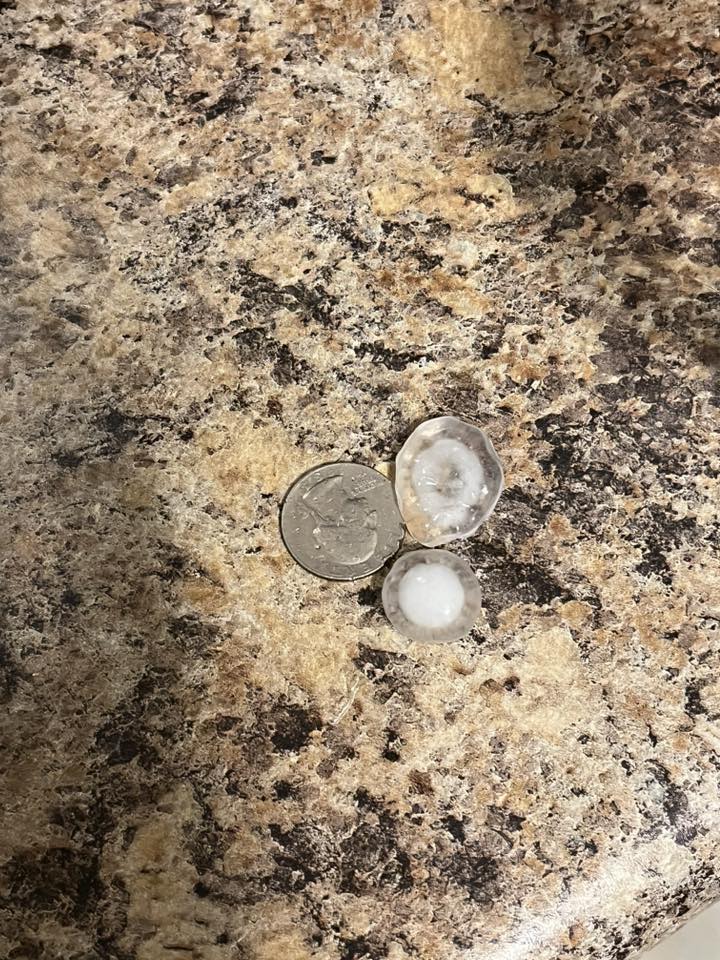
Got some quarter hail and strong winds, not sure of what the wind damage looks like though in Downers Grove/Woodridge area.
-
2025 Short Range Severe Weather Discussion
pen_artist replied to Chicago Storm's topic in Lakes/Ohio Valley
Lots of branches down here in the Woodridge/DG area. Agreed with above, best storm of year so far -
Solid wind bag here in Downers Grove
-
2025 Short Range Severe Weather Discussion
pen_artist replied to Chicago Storm's topic in Lakes/Ohio Valley
Things starting off with a bang I guess. Got a few TOR warnings and a PDS warning in Wisconsin. -
2025 Short Range Severe Weather Discussion
pen_artist replied to Chicago Storm's topic in Lakes/Ohio Valley
Sneaky ENH risk issued on this latest update. Still looks like activity dies some as it gets to NE IL though.
-
18z HRRR doesn't look as bad for Chicagoland showing some stronger convection firing off around noon and racing NE.