pen_artist
-
Posts
109 -
Joined
-
Last visited
Content Type
Profiles
Blogs
Forums
American Weather
Media Demo
Store
Gallery
Everything posted by pen_artist
-
Brining me back to 2014-16 summer times. Love it
-
Lots of discussion concerning ring of fire pattern setting up with this heatwave coming through. Honestly feeling like we'll get missed north this time around
-
Still a lot of summer left. Hoping you snag a great, closer chase
-
Likely strong tornado ongoing in IA heading toward southwest/west wisconsin
-
Does anyone have any good examples of when the warm front has advanced far north in just a few hours i.e. low central IL to far N IL? It feels like more often than not models will suggest this can happen but often it just stalls or barely retreats north.
-
Little under 48 hours out looks like a thread the needle event for areas of DuPage and Cook near the city. Will be incredibly fast storm motion
-
I want to believee
-
TORE now. Unbelievable.
-
So clearly defined. Haven't seen a clear, detached debris ball like that in a while. Nothing much else impeding it either in the near term outside of the two small cells to its southeast
-
Lots of chasers reporting VERY strong winds leading to quick recovery. Will see how much that affects Chicagoland area but do think we recover some compared to previous crapvection days
-
-
Assuming I am reading my UTC times correctly, this was pretty spot on with winds so far.
-
Might some convergence on the line as it approaches Elburn, IL area
-
Are you referring to Thursday? Because I am seeing/wondering same. The convection isn't quite as large/robust at the very end of run but a bit more discrete than earlier models
-
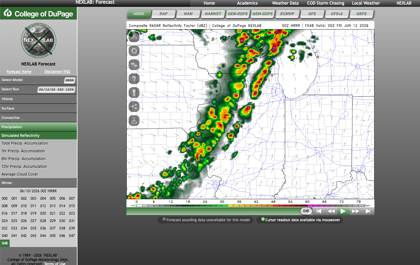
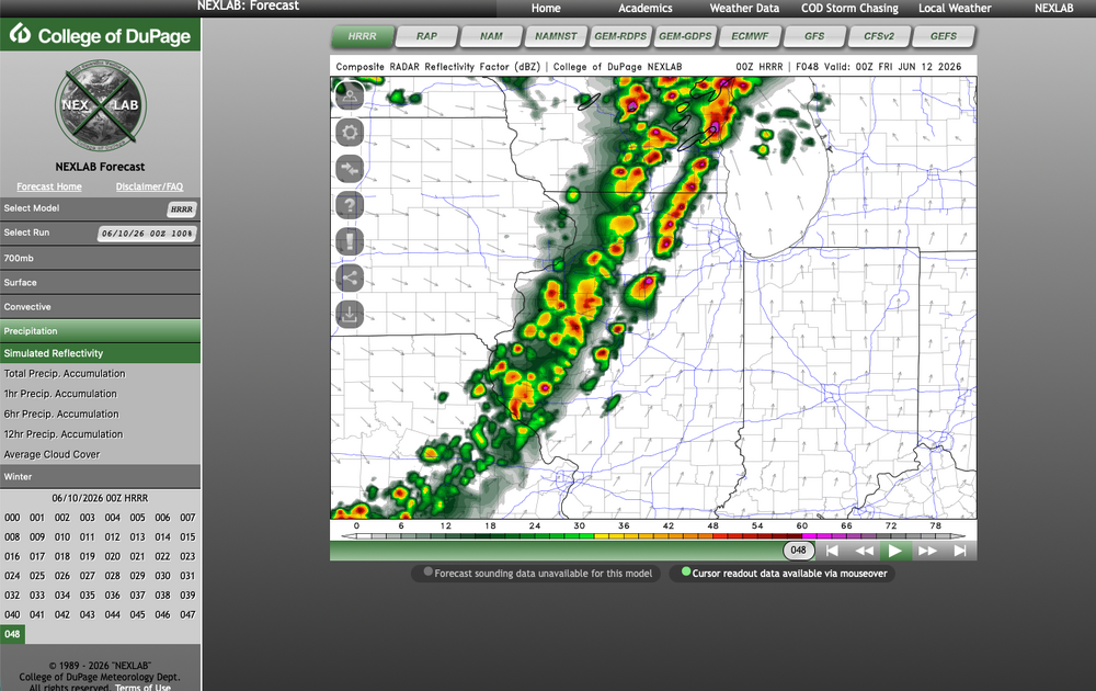
The end of the 18z HRRR also showing a well recovered powder keg of an atmosphere early afternoon Thursday. Can't imagine what 00z runs will show if trends continue
-
Are we back? Looking like a more active week ahead for a lot of us Hazardous Weather Outlook National Weather Service Chicago/Romeoville IL 430 AM CDT Mon Jun 8 2026 ILZ003>006-008-010>013-019>021-023-032-033-039-103>108-INZ001-002- 010-011-019-090930- Winnebago-Boone-McHenry-Lake IL-Ogle-Lee-De Kalb-Kane-DuPage- La Salle-Kendall-Grundy-Kankakee-Livingston-Iroquois-Ford- Northern Cook-Central Cook-Southern Cook-Northern Will- Southern Will-Eastern Will-Lake IN-Porter-Newton-Jasper-Benton- 430 AM CDT Mon Jun 8 2026 /530 AM EDT Mon Jun 8 2026/ This Hazardous Weather Outlook is for portions of north central Illinois...northeast Illinois and northwest Indiana. .DAY ONE...Today and Tonight. Weather hazards expected... Elevated Thunderstorm Risk. Elevated Flooding Risk. DISCUSSION... Several periods of showers and thunderstorms are expected today. The strongest will produce torrential rainfall rates, which may lead to localized flash flooding. In addition, a funnel cloud cannot be ruled out. .DAYS TWO THROUGH SEVEN...Tuesday through Sunday. Tuesday night through Thursday... Limited to Elevated Flooding Risk at times. Limited to Elevated Severe Thunderstorm Risk at times. DISCUSSION... Several periods of severe thunderstorms may occur in the general region Tuesday night through Thursday. Locally, the greatest threat for severe weather will be on Thursday. .SPOTTER INFORMATION STATEMENT... Spotter activation will not be necessary through tonight. GENERAL STORM MOTION OF THE DAY: Moving toward the north at around 20 mph.
-
If you play your cards right you might catch a few quality boomers today!
-
Got a good three week trip this May so somewhat glad for this lull while I am away
-

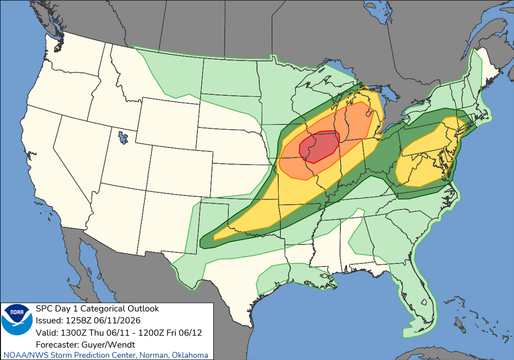
Potential Sever Weather Outbreak 4/27/2026
pen_artist replied to pen_artist's topic in Lakes/Ohio Valley
I feel like if there is really any chance at svr in NIL it would be late evening. 10 and 11z (haven't look back more) hint at at least thunderstoms with some rotation moving through the 9 PM -12 AM timeframe. -
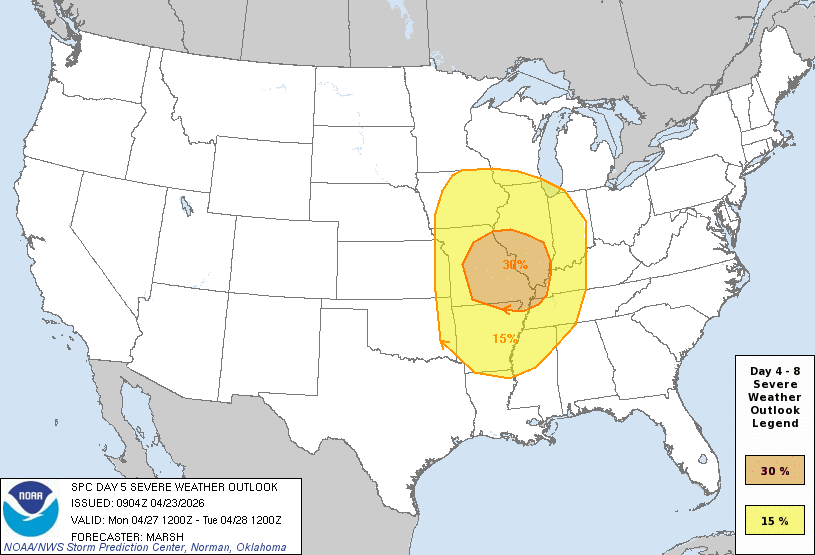
Large D4 30% contour for much of IL and parts of WI, IN, IA, MO, AR, TN and KY. Mention of strong tornadoes but not as strong of wording as I'd expect. Regardless, shaping up to be another all hazards possible event especially if things can remain more supercellular. ...DISCUSSION... Latest medium-range model output suggests that a significant short wave perturbation emerging from the Southwest will pivot northeast of the middle/lower Missouri Valley, into the upper Great Lakes region, Monday through Monday night. It appears that the warm sector of an associated sub-1000 mb surface cyclone will become characterized by at least moderately large CAPE, ahead of the dryline/cold front overspreading much of the middle Mississippi Valley during the afternoon into evening. In the presence of strong deep-layer shear, organized severe thunderstorm activity appears probable. It remains a bit unclear the extent to which sustained supercell development will be maintained, as opposed to convection quickly growing upscale into one or more clusters/lines, but there appears at least some potential for a few strong tornadoes, in addition to large hail and potentially widespread strong to severe wind gusts.
-
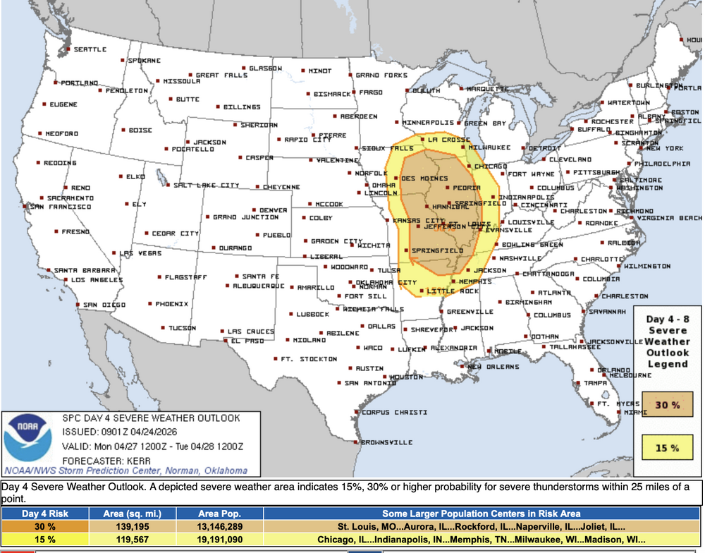
Very large warm sector with much of the western sub highlighted in the 15% for Day 5, Monday 4/27
-
90 mph warned winds headed toward Davenport
-
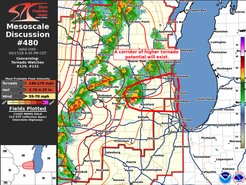
MD on that Rockford cell Mesoscale Discussion 0480 NWS Storm Prediction Center Norman OK 0442 PM CDT Fri Apr 17 2026 Areas affected...Southern Wisconsin and far northern Illinois Concerning...Tornado Watch 129...131... Valid 172142Z - 172345Z The severe weather threat for Tornado Watch 129, 131 continues. SUMMARY...Leading supercells across northern Illinois and southern Wisconsin will likely pose a tornado (possibly significant) and very large hail threat as they move downstream over the next 1-2 hours. DISCUSSION...A pair of leading supercells continues to precede a broken line of storms along the IL/WI border. Regional radar imagery continues to indicate that these cells are rather intense with a three-body scatter spike, a bounded weak echo region, and a recent 3-inch hail report noted with the southern storm. An improving downstream convective environment is noted in recent observations and analyses (0-1 km SRH values remain between 200-250 m2/s2 per the KMKX VWP, and STP values have recently increased to 2-3 per recent mesoanalysis). Additionally, the southern storm will also likely propagate along a subtle surface theta-e gradient draped across northern IL to southern WI. Given these trends and the presence of a well-established updraft/mesocyclone with the southern cell, the potential for very large hail (likely in excess of 2 inches) and strong tornadoes will likely persist for the next couple of hours downstream into southeast WI and far northern IL. ..Moore.. 04/17/2026 ...Please see www.spc.noaa.gov for graphic product... ATTN...WFO...LOT...MKX...DVN... LAT...LON 42138771 42158906 42268948 42378957 42608965 42798955 42968903 43188791 43108770 42848764 42588767 42138771 MOST PROBABLE PEAK TORNADO INTENSITY...140-170 MPH MOST PROBABLE PEAK WIND GUST...55-70 MPH MOST PROBABLE PEAK HAIL SIZE...2.75-4.25 IN
-
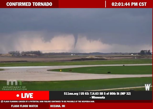
Pretty scenic live cam of the Rochester MN tornado
-
@andyhb What are your thoughts on QLCS tor threat in Chicago area?